Passport
I. Category — High-altitude 2. Tian-Shan, Tengri-Tag ridge 3. Khan-Tengri Peak 103 South-West edge (V. Sviridenko, 82) 4. 6B cat. diff. (2nd ascent) 5. Height difference 2725 m, length 4920 m.
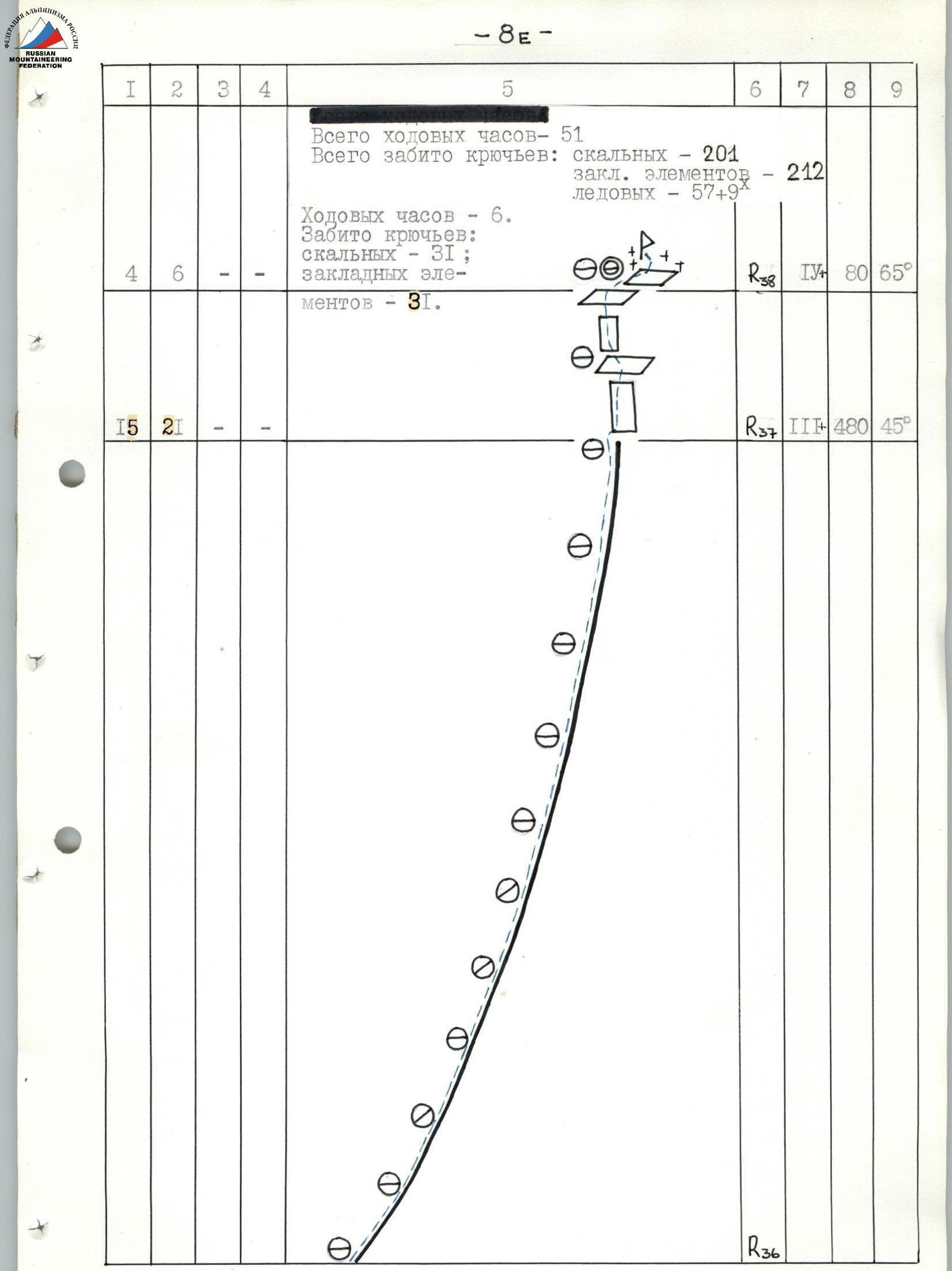
- Length of 6A–6B cat. diff. sections 480 m.
Average steepness of the main part of the route — 62°. 6. Hooks left on the route (not extracted) — none.
Previously driven hooks used and not extracted — 3 piton hooks. 7. Team's travel hours: 51 hours and days — 11. 8. Overnights: 1, 2, 11th — rocky platform for 4 people,
3rd and 5th — two platforms for 2 people, carved on a snow-ice slope. 4, 6–10th — platform for 4 people, carved on a snow-ice slope. 9. Leader: Rybchenko Vladimir Dmitrievich — Master of Sports of the USSR
Participants:
- Gerasimov Alexander Anatolyevich — Candidate Master of Sports
- Melnikov Vladislav Ivanovich — Candidate Master of Sports
- Staroselsky Evgeny Alexandrovich — Candidate Master of Sports
- Coach: Grigorenko-Prigoda Yuri Ivanovich — Master of Sports of the USSR.
- Entry to the route: August 3, 1990.
Summit August 13, 1990.
Return August 15, 1990.
12. Organization — Ukrainian Alpine Federation, Kharkov Regional Alpine and Rock Climbing Club

Photo 1. General view.
- Date: August 5, 1988.
- Time: 16:00
- Equipment: " Industar "
- Focal length: f = 58 mm
- Shooting height: hshooting = 4300 m
- Shooting point: #2
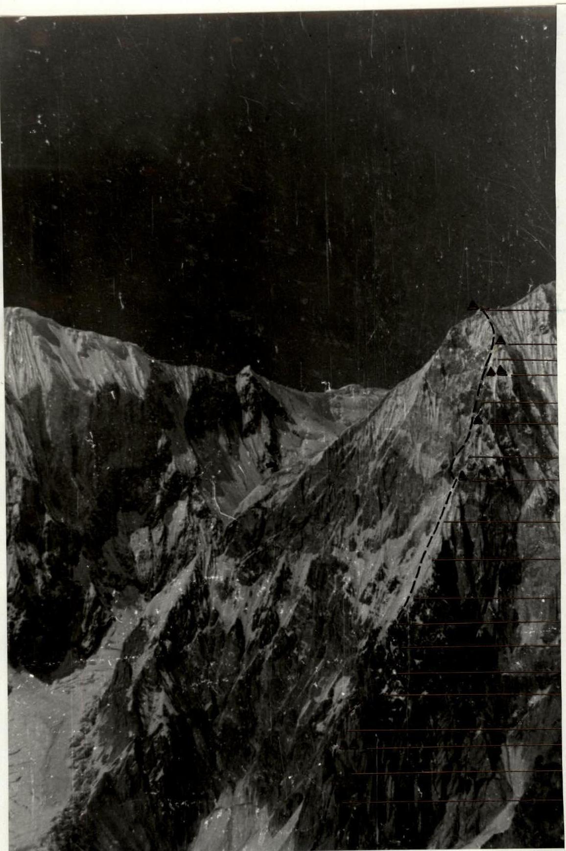
Photo 2. Photograph of the wall profile on the right.
- Date: August 1, 1990.
- Time: 16:30
- Equipment: " Industar "
- Focal length: f = 58 mm
- Shooting height: hshooting ≥ 5800 m
The photograph was taken from a helicopter. It is not possible to obtain a snapshot of the left wall profile due to the objective danger of possible shooting points.
Tactical actions of the team
The tactics of the route were largely determined by the sharp deterioration of the weather from August 4 to 13 and the associated change in the state of the route (see photo 7, sheet 16/4). The snowfall on August 3–4, repeated on August 6–8, caused snowing and icing of the rock sections of the main part of the route "triangle" (R0–R32), increased the avalanche danger of snow-ice slopes. Strong southeast wind, snowfall, and lack of visibility on August 11–13 made movement difficult in the upper part of the route "sickle" (R33–R37). Changes were made to the initial tactical plan aimed at improving safety, and technical techniques and means of passing the route were adjusted. As a result of these changes, unplanned overnight stays were organized:
1st (August 3) — stopped moving due to the onset of snowfall and poor visibility; 2nd (August 4) — forced day off due to continuous snowfall and lack of visibility; 4th (August 6) — stopped moving due to the objective danger of passing the ice-filled chimney (R16–R17) (intensive melting causes water to flow, ice fragments fall); 7th (August 9) — forced day off due to snowfall and lack of visibility; 10th (August 12) — stopped moving due to the onset of a thunderstorm.
Nevertheless, the team managed to maintain the high pace of movement planned before the exit — the route was completed in 51 travel hours.
The team's movement (1st rope team — Rybchenko — Melnikov, 2nd — Gerasimov — Staroselsky) was carried out with:
- interaction between rope teams,
- change of the leading rope team and the leader within the rope teams.
On sections of grade 3 difficulty, the rope teams moved autonomously.
For belaying, the entire set of equipment taken on the route was used.
On rocky sections, placement elements were widely used, including self-expanding types such as "friends".
On snowy sections, the following were used:
- avalanche shovels
- ice axes with cable loops
On the "triangle", the leader's belay was carried out with a double rope.
The mode of movement was mainly determined by:
- weather conditions
- considerations of the safety of passing the route
One of the features of the main part of the route is the lack of convenient places for overnight stays, which was also taken into account when determining the mode of movement. To organize a safe and restful bivouac, especially considering bad weather, it took a lot of time. Most overnight stays were located on cut snow-ice ridges and were quite comfortable.
Throughout the route, daily hot meals were organized twice a day, and individual high-calorie daily rations and vitamins were distributed to team members (see the table of food and fuel, sheet 7A), which helped maintain the team's high performance.
Overcoming the most difficult sections of the route was ensured by:
- the necessary level of sports qualification of the team members, allowing the use of various technical and tactical techniques;
- a wide range of equipment.
The lower rocky bastion (R0–R5) and "black rocks" (R16–R25) were passed by free climbing. Artificial points of support were used only when passing through the ice-filled chimney (R16–R17). Due to heavy snowing on rocky sections, movement along the entire route, except for the section (R0–R5) passed before the snowfall, was carried out in crampons.
Visual observation of the team was carried out by a group of observers located on the "4250" moraine directly below the start of the route. After the team passed the "black rocks" R25, observation was carried out from the base camp through a spyglass. For radio communication with the observation group, "YETSU" radio stations were used.
Throughout the ascent, a rescue team consisting of climbers with the right to exit on a route of 6B category difficulty, with high-altitude climbing experience, and having climbed Khan-Tengri Peak in the 1990 season, was located in the base camp.
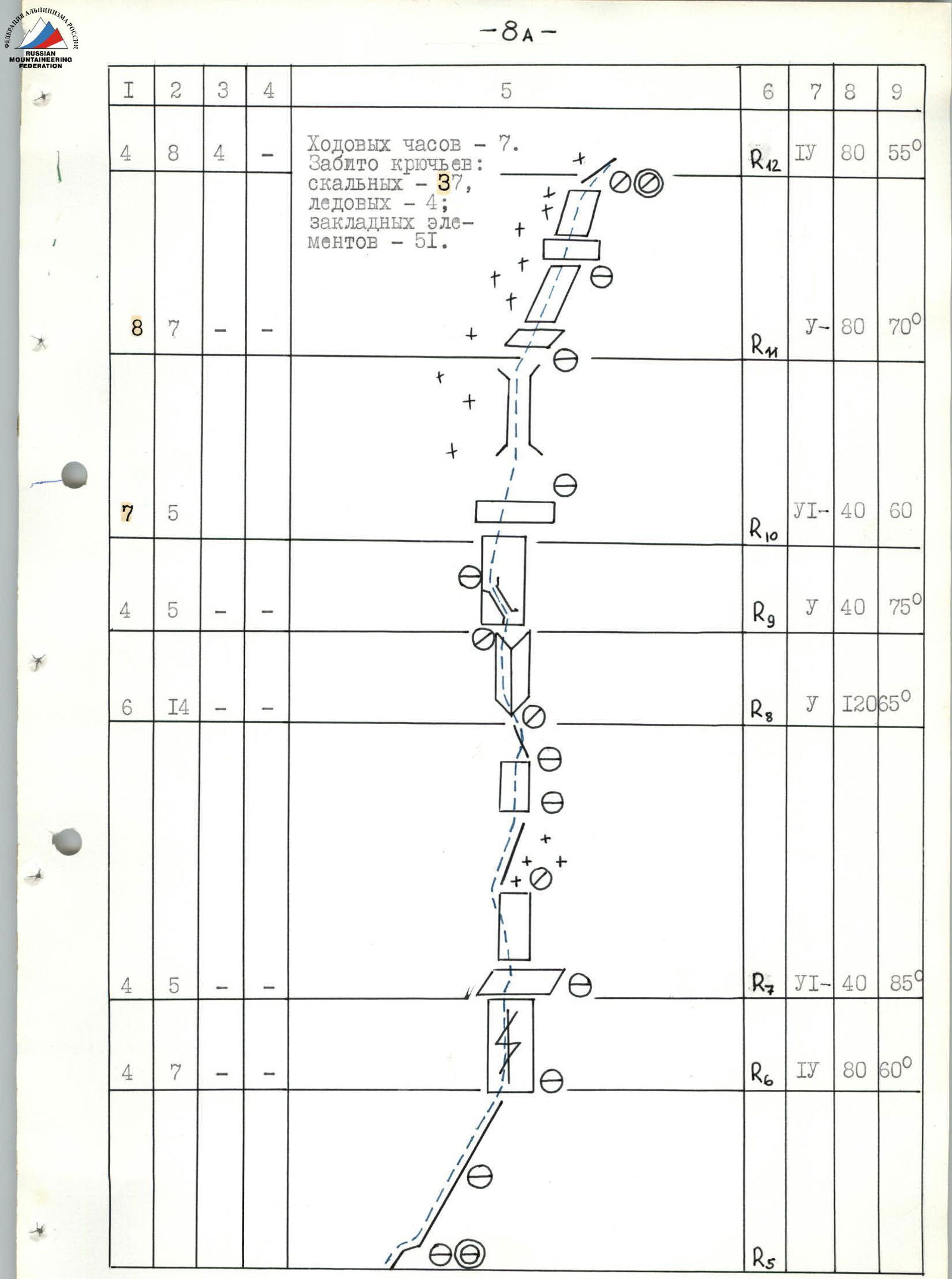
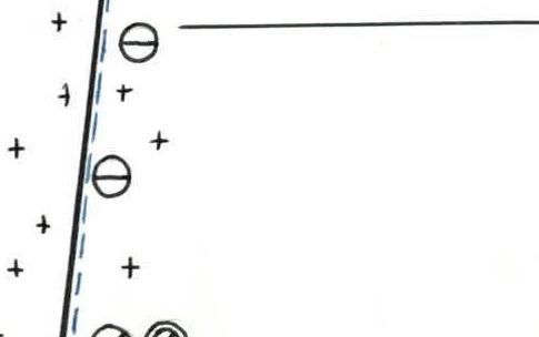
Route diagram in UIAA symbols (M 1:2000)
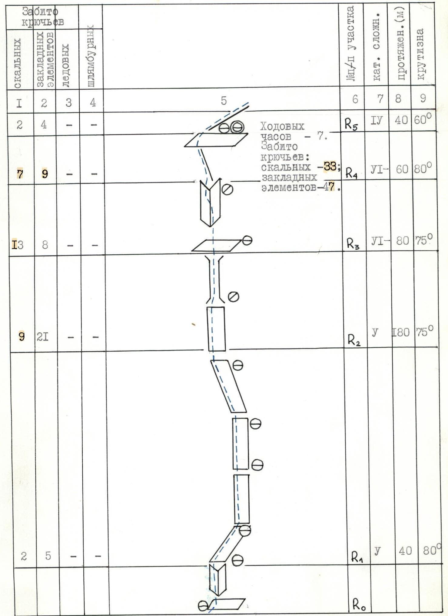
8A
| Driven rock hooks | Driven placement hooks | Driven ice hooks | Driven piton hooks | 5 | 6 | 7 | 8 | 9 |
|---|---|---|---|---|---|---|---|---|
| — | — | 11 | — | 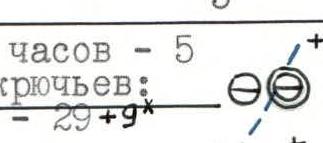 | ||||
 | ||||||||
| — | — | 10 | — |  | ||||
 | ||||||||
| — | — | 5 | — |  | ||||
 | ||||||||
| — | — | 3 | — | 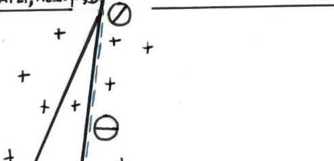 | ||||
 | ||||||||
 | ||||||||
| I | 2 | 3 | 4 | 5 | 6 | 7 | 8 | 9 |
| 2 | 4 | 4 | — | Travel hours — 7. Driven hooks: rock — 33; placement — 47. | R5 | 4 | 40 m | 60° |
| 7 | 9 | — | — | R4 | 1 | 60 m | 80° | |
| 13 | 8 | — | — | R3 | 1 | 80 m | 75° | |
| 9 | 21 | — | — | R2 | 5 | 180 m | 75° | |
| 2 | 5 | — | — | R1 | 5 | 40 m | 80° | |
| 4 | 8 | 4 | — | Travel hours — 7. Driven hooks: rock — 37, ice — 4; placement — 51. | R12 | 4 | 80 m | 55° |
| 8 | 7 | — | — | R11 | 5 | 80 m | 70° | |
| 7 | 5 | — | — | R10 | 6 | 40 m | 60° | |
| 4 | 5 | — | — | R9 | 5 | 40 m | 75° | |
| 6 | 14 | — | — | R8 | 5 | 120 m | 65° | |
| 4 | 5 | — | — | R7 | 1 | 40 m | 85° | |
| 4 | 7 | — | — | R6 | 4 | 80 m | 60° | |
| — | — | 11 | — | Travel hours — 5. Driven hooks: ice — 29+9*. | R16 | 5 | 150 m | 65° |
| — | — | 10 | — | R15 | 4 | 150 m | 55° | |
| — | — | 5 | — | Belay through 4 avalanche shovels, ice axe. | R14 | 4 | 120 m | 50° |
| — | — | 3 | 5* | R13 | 4 | 80 m | 45° | |
| 7 | 6 | 2 | — | Travel hours — 6. Driven hooks: rock — 24, ice — 2, placement — 24. | R25 | 5 | 100 m | 70° |
| 8 | 9 | — | — | R24 | 1 | 70 m | 80° | |
| 4 | 4 | — | — | R23 | 4 | 40 m | 60° | |
| 5 | 5 | — | — | R22 | 6 | 30 m | 80° | |
| 5 | 15 | — | 1 | Travel hours — 5. Driven hooks: rock — 33, ice — 1, placement — 37. | R21 | 5 | 100 m | 70° |
| 5 | 9 | — | — | R20 | 6 | 50 m | 80° | |
| 1 | 4 | — | — | R19 | 4 | 30 m | 65° | |
| 14 | 5 | — | — | R18 | 5 | 70 m | 75° | |
| 7 | 2 | 2 | — | R17 | A2, 6 | 30 m | 90° | |
| 12 | 4 | — | — |  | R34 | 3 | 160 m | 45° |
| 2 | 2 | — | — |  | ||||
 | ||||||||
 | ||||||||
 | ||||||||
 | ||||||||
 | ||||||||
 | ||||||||
 | ||||||||
 | ||||||||
 | ||||||||
 | ||||||||
 | ||||||||
 | ||||||||
 | ||||||||
 | ||||||||
 | ||||||||
 | ||||||||
 | ||||||||
 | ||||||||
 | ||||||||
 | ||||||||
 | ||||||||
 | ||||||||
 | ||||||||
 | ||||||||
 | ||||||||
 | ||||||||
 | ||||||||
 | ||||||||
 | ||||||||
 | ||||||||
 | ||||||||
| 1 | 2 | 3 | 4 | 5 | 6 | 7 | 8 | 9 |
| 12 | 4 | — | — | R36 | 3 | 160 m | 45° | |
| 3 | 2 | — | — | R35 | 3 | 60 m | 40° | |
| 15 | 9 | — | — | R34 | 3 | 300 m | 45° | |
| 4 | 6 | — | — | Travel hours — 6. Driven hooks: rock — 31; placement — 31. | R38 | 4 | 80 m | 65° |
| 15 | 21 | — | — | R37 | 3 | 480 m | 45° |
8E
Description of the route by sections
The sharp deterioration of the weather and the associated changes in the state of the route led to a change in the initial tactical plan, some differences in the choice of direction of movement, technical and tactical techniques, methods and techniques of organizing insurance, and, accordingly, to a difference from previously known descriptions.
A characteristic feature of the relief of the lower rocky bastion (R0–R8) is the strong destruction and fragility of the marble rocks with a fairly high steepness (72°). Along with the typical lack of cracks for rocks of this type, this creates difficulties in organizing anchor points. The correct choice of direction of movement by the leader is crucial to avoid dropping stones on partners.
In the upper part of the bastion (R7–R8), the rocks are stronger, there are steep monolithic walls, alternating with dissected snowy and rocky ridges.
When organizing insurance, the following were most often used:
- thin rock hooks
- placement elements such as "stoppers" (№1–4)
- placement elements such as "friends" (№2–3)
The overnight stay was organized on a rocky platform R5. There are not many convenient places for a bivouac — R3 (there is water) and R5.
Above the rocky bastion is a section (R8–R12), where diverse rocky relief alternates with snowy and snow-ice ridges and walls. On snowy rocks, there are sections covered with rime ice (R9–R10).
Organizing insurance did not cause particular problems, the most frequently used were:
- thin rock hooks,
- channel hooks,
- placement elements such as "stoppers" (№2–4).
A place for overnight stay was carved on a snow-ice slope under the cover of rocky walls; there are no convenient places for overnight stays.
The snow-ice "knife" (R12–R16) begins with a steep snow-ice slope, which leads to a sharp ice ridge. In the upper part, the ridge is divided into a system of ice ridges separated by couloirs.
The nature and condition of the snow-ice sections changed from:
- deep loose snow in the lower part to the exit to the ridge
- porous firn ice on the ridge
Insurance was carried out on ice screws; avalanche shovels and ice axes with cable loops were also used in the lower part.
A place for overnight stay was carved on the ice ridge at the end of the "knife"; there are no convenient places for a bivouac.
The upper rocky bastion "black rocks" (R16–R25) is characterized by high steepness (71°), heavy snowing and icing of rocks, and a variety of rocky and snow-ice relief.
The structure of the rocks, composed of schists and granites, and the presence of numerous ice sections allowed for the organization of reliable insurance. Mainly used for insurance were:
- thin rock hooks,
- channel hooks,
- placement elements such as "stoppers" (№1–5),
- placement elements such as "hex" (№4–5).
A place for overnight stay was carved on an ice ridge under the cover of a rocky cornice; there are no convenient places for a bivouac.
Above the "black rocks" is a section (R25–R29), where rocky walls alternate with a system of snow-ice couloirs. The feature of this section was the objective danger of movement through the couloirs caused by abundant snowfall, heavy snowing and icing of rocky sections, and unfavorable weather conditions. All this made movement and insurance organization difficult.
A place for overnight stays was carved on a snow-ice ridge; there are no convenient places for a bivouac.
The snow-ice ridge (R29–R32), leading to the top of the "triangle", is characterized by the presence of peculiar snow-ice formations — "mushrooms", making it difficult to orient on the route, as well as a porous ice structure.
The correct choice of direction of movement is crucial, allowing the use of relief features for insurance organization.
Movement was mainly carried out through a system of snow-ice ridges, bypassing the "mushrooms".
For insurance organization, the following were used:
- ice screws
- avalanche shovels
- ice axes with cable loops.
A place for overnight stay was carved on a snow-ice ridge; there are no convenient places for a bivouac until the exit to the top of the "triangle".
The upper part of the route from the top of the "triangle" to the summit of Khan-Tengri Peak is a:
- relatively simple snow-ice slope (R32–R33)
- extended rocky edge, ending with the summit tower — "marble edge" (R33–R38)
Despite a significant decrease in steepness and technical difficulty in this section of the route, overcoming it faces specific challenges due to:
- the high-altitude nature of the ascent (cold, strong wind),
- relief features (weak dissection of the "marble edge").
In this regard, the correct distribution of forces on the route is especially important, allowing for the necessary reserve to be maintained. It is worth noting that the team managed to solve this task and, in addition to their own program on the descent, ensured the conduct of rescue operations (transportation of two climbers from the K. Kondo-Japan group) from the summit to the "4200 m" moraine.
For insurance organization on the "marble edge", the most frequently used were:
- thin rock hooks
- placement elements such as "stoppers" (№1–3).
Places for overnight stays were carved on snow-ice slopes, directly on the "marble edge" and up to the exit to the summit tower; there are no convenient places for overnight stays.
The tactical schemes used in organizing movement allowed for an even distribution of forces among team members and took into account individual training features. The work was carried out in rope teams:
- 1st — Rybchenko — Melnikov
- 2nd — Gerasimov — Staroselsky
The rope teams worked alternately at the front, the leader was changed within the rope teams, and interaction between the rope teams was organized.
To ensure the reliability of passing the route and maintaining a high pace of movement, the leader worked with a lightened backpack, on the section (R0–R5) — in rock shoes. Due to changes in the state of the route as a result of snowfall on August 3–4:
- the leader moved in