Passport
I. Category of mountaineering ascent. 2. Tian-Shan, Tengri-Tag ridge. 3. Peak Khan-Tengri 103 SSW edge (V. Sviridenko, 82). 4. 6B category of difficulty. 5. Height difference 2590 m, length 3820 m.
Length of sections 5–6 category of difficulty — 840 m. Length of sections 6 category of difficulty — 380 m. Average steepness of the main part of the route — 58°.
- Number of anchors used:
- rock anchors — 116
- protection equipment — 120
- ice screws — 101
- Team's total climbing hours — 53 h, days — 5.
- Overnights:
- 1st — in a tent on a cut ice ridge;
- 2nd, 3rd — in a tent on a snow overhang;
- 4th — in a tent under a "tooth" in a snow-ice cirque.
- Team leader: Pogorelov Alexander Grigorievich — Master of Sports of International Class.
Team members:
- Moiseev Alexander Anatolyevich — Candidate Master of Sports
- Zaporozhsky Mikhail Yuryevich — Candidate Master of Sports
- Koshelenko Yuri Vladimirovich — Candidate Master of Sports.
-
Senior coach — Pogorelov Alexander Grigorievich. Coach — Shandulin Vladimir Ivanovich. II. Route start — August 7, 1992. Summit — August 11, 1992. Return — August 12, 1992.
-
Organizing body — Rostov-on-Don Department of Physical Culture and Sports and Rostov Regional Federation of Mountaineering and Rock Climbing.
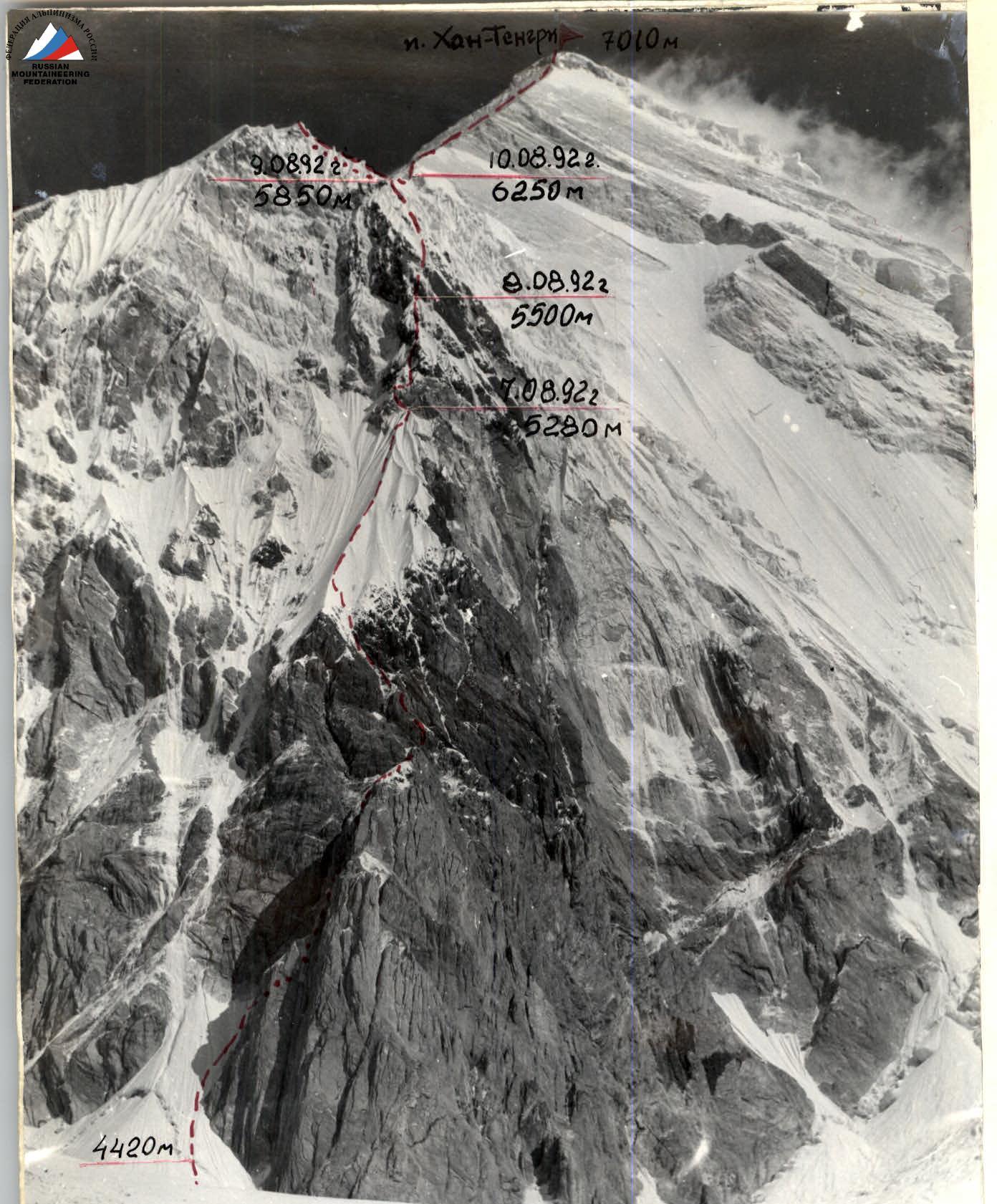 Photo 1. General photo of Khan-Tengri peak. August 4, 1992, 14:00. "Smena-8M" camera. Shooting height — 4500 m. Point of shooting I. Distance to the object — 3000 m. Route of the Rostov-on-Don Department of Physical Culture and Sports team.
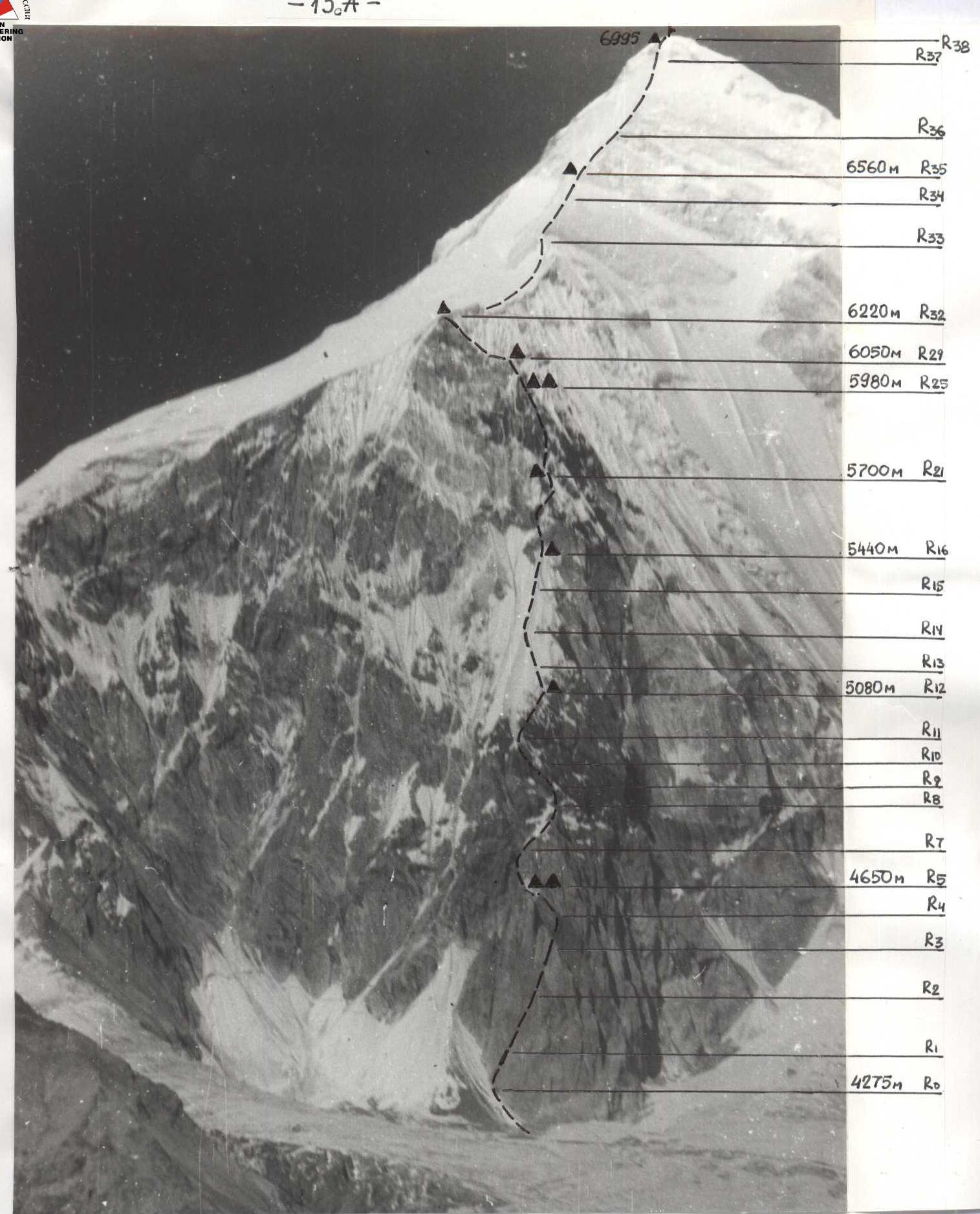 Photo 5. Technical photo of the route (August 1, 1990, 16:30, "Industar" f=58 mm, h shooting 5800 m). Photo taken from a helicopter.
 5280 m
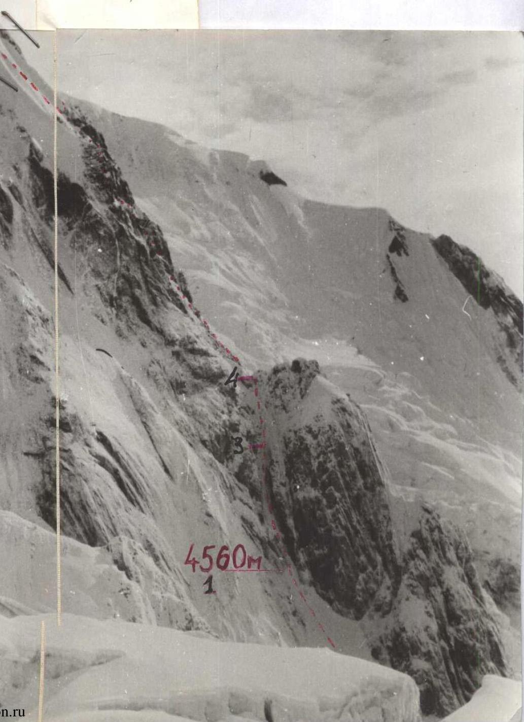
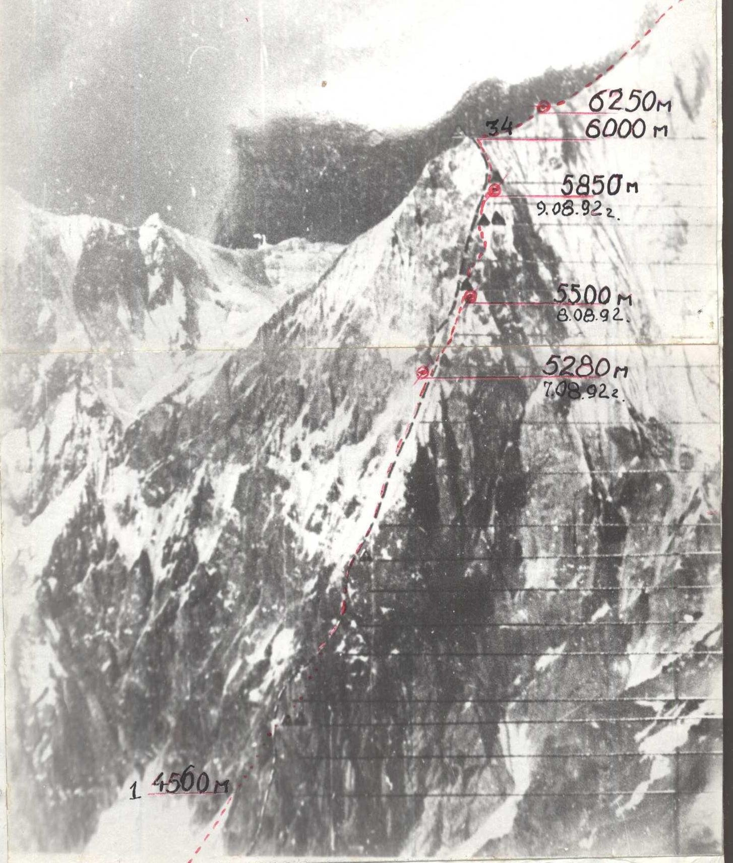 Photo №2. ROUTE PROFILE FROM THE RIGHT. Based on the ascent by the Kharkov team in 1990.
- route of the Rostov team
- overnight stops.
Tactical actions of the team
Overall, the ascent was carried out according to the tactical plan. The planned number of overnight stops on the route was four, and the number of climbing days was five, which was realized by the team during the ascent. However, the state of the route (the ascent took place after a period of bad weather) introduced some adjustments to the speed of passing certain sections.
On the first day of the ascent, August 7, good weather and our physical and technical preparedness allowed us to reach the site of the 1st planned overnight stop by 14:00. Therefore, we decided to continue moving, pass the "knife," and set up a bivouac at the site of the second planned overnight stop. Thus, we completed part of the work planned for the second day.
Based on the large amount of work done on the first day and the fact that the team had fully expended its reserve time, we decided to start work the next day at 10:00, somewhat later than the time specified in the tactical plan, in order to restore our strength.
The large amount of snow on the route, which continued to fall during the ascent, required a lot of effort not only for passage but also for setting up a bivouac at the end of the working day. Based on this, we decided to start our working day at 9:00, also with the aim of more fully restoring our strength.
We had two descent options at our disposal: along the ascent route and along the classic route to the saddle between the peaks of Chapayev and Khan-Tengri.
Considering that we had caves on the saddle, which we had dug for an overnight stay during an acclimatization exit, we left the tent at the "tooth" and took with us:
- warm clothing
- mats
- hot tea in thermoses in case we had to descend towards the saddle.
Due to strong winds on the "marble" ridge, the ascent to the summit became possible only at 20:00, and we decided to descend towards the saddle.
The next day, a team of two climbed to the bivouac site at the "tooth" and retrieved the tent with the remaining equipment.
The organization of the work of the rope teams was based on the principle of optimal distribution of the team's strength.
The work of the leaders was distributed as follows:
- Pogorelov — sections R1–R3, R12–R14, R23–R27
- Zaporozhsky — sections R3–R12, R27–R28
- Koshelenko — sections R14–R18, R28–R29
- Moiseev — sections R18–R23, R29–R34
Sections R0–R1, R34–R40 were worked on autonomously by the rope teams.
The main problem when passing the route was the "empty" (porous) snow, both on the ridge and on the rocks. This required special techniques. A shovel was specially taken for traversing the ridges and for belaying on them.
The first climber worked on a UIAA 12 mm rope, and his belay was carried out through an improved "bug" by Kozhevnik. The belay point was organized from three elements, balanced by a load-sharing loop. The movement of the other participants was carried out along the fixed ropes with belay.
During the ascent, constant radio communication was maintained with observers and the rescue team.
List of products
| Product name | Quantity in grams taken | Note |
|---|---|---|
| Spaghetti | 1000 g | |
| Freeze-dried potatoes | 1000 g | |
| Smoked sausage | 1000 g | |
| Lard | 1000 g | |
| Hard cheese | 1000 g | |
| Processed cheese | 400 g | |
| Butter | 300 g | |
| Wheat crackers | 2000 g | |
| Dried milk | 200 g | |
| Cookies | 1000 g | |
| Bread | 500 g | |
| Freeze-dried soups | 200 g | |
| Bouillon cubes | 100 g | |
| Salt, tomato paste | 600 g | |
| Caramel candies | 800 g | |
| Chocolate candies | 400 g | |
| Chocolate | 300 g | |
| Raisins, dried apricots | 1200 g | |
| Honey | 300 g | |
| Canned fish | 700 g | |
| Dried fish | 600 g | |
| Tea | No | 100 g |
| Vitamins, rehydration salts, ascorbic acid | 300 g | |
| Fresh apples | 1000 g | |
| Total | 16000 g |
Based on the calculation: 500 g × 4 people × 6 days = 12 kg. Emergency supply: 500 g × 4 people × 2 days = 4 kg.
Description of the route in UIAA symbols
| Section № | Protection equipment | Rock anchors | Ice screws | Length, m | Steepness, ° | Category of difficulty |
|---|---|---|---|---|---|---|
| R0–R1 | — | — | — | 200 | 45 | 3 |
| R1–R2 | — | — | 17 | 80 | 75 | 6 |
| R2–R3 | — | — | 5 | 40 | 65 | 4 |
| R3–R4 | — | — | 3 | 40 | 50 | 4 |
| R4–R5 | — | — | — | 30 | 30 | 2 |
| R5–R6 | — | 5 | — | 50 | 70 | 3 |
| R6–R7 | — | — | — | 15 | 50 | 3 |
| R7–R8 | — | 6 | — | 30 | 75 | 5 |
| R8–R9 | — | 2 | 8 | 50 | 60 | 3 |
| R9–R10 | — | 6 | 3 | 100 | 45 | 3 |
| R10–R11 | — | 7 | — | 200 | 45 | 3 |
| R11–R12 | — | 12 | — | 150 | 50 | 4 |
| R12–R13 | — | 6 | — | 40 | 60 | 5 |
| R13–R14 | — | 4 | — | 20 | 75 | 6 |
| R14–R15 | 6 | 1 | — | 30 | 80 | 6 |
| R15–R16 | 2 | 3 | 2 | 40 | 70 | 5 |
| R16–R17 | — | 3 | 3 | 50 | 55 | 4 |
| R17–R18 | — | 6 | 4 | 40 | 75 | 6 |
| R18–R19 | — | 3 | 8 | 40 | 65 | 5 |
| R19–R20 | — | — | 2 | 10 | 70 | 5 |
| R20–R21 | — | 4 | — | 20 | 80 | 6 |
| R21–R22 | — | — | — | 10 | 60 | 6 |
| R22–R23 | — | 2 | 2 | 10 | 20 | 3 |
| R23–R24 | 4 | 1 | — | 40 | 70 | 5 |
| R24–R25 | 7 | 6 | 1 | 50 | 75 | 6 |
| R25–R26 | 1 | 2 | 2 | 30 | 70 | 5 |
| R26–R27 | — | — | 18 | 120 | 65–70 | 5 |
| R27–R28 | 1 | 4 | — | 20 | 70 | 6 |
| R28–R29 | — | 7 | — | 30 | 65 | 5 |
| R29–R30 | 1 | 6 | 1 | 30 | 80 | 6 |
| R30–R31 | 2 | 4 | 6 | 5 | 20 | 3 |
| R31–R32 | — | 4 | — | 120 | 60 | 6 |
| R32–R33 | — | — | — | 20 | 60 | 3 |
| R33–R34 | — | 1 | 7 | 40 | 60 | 5 |
| R34–R35 | — | — | — | 500 | 30 | 2 |
| R35–R36 | — | 1 | 11 | 100 | 40 | 2 |
| R36–R37 | 12 | 38 | — | 450 | 45 | 3–4 |
| R37–R38 | 49 | 21 | — | 700 | 50 | 3 |
| R38–R39 | — | 4 | — | 40 | 50 | 3 |
| R39–R40 | — | — | — | 30 | 40 | 2 |
| R40–R41 | — | — | — | 100 | 20 | 1 |
Summary by days:
- August 7, 1992. Climbing hours 12.5. Approach to the route — 1420 m.
- August 8, 1992. Climbing hours 10.
- August 9, 1992. Climbing hours 9.
- August 10, 1992. Climbing hours 10.5.
- August 11, 1992. Climbing hours 11. Length — 1420 m.
R0–R1 — wide snow couloir. R1–R3 — wide chimney filled with wet, porous ice. Belay through ice screws. To pass and organize belay, it is necessary to clear the upper layer. Belay points are hanging. R3–R4 — the chimney turns into a wide couloir. Belay through ice screws. R4–R5 — simple snow-covered ridge. R5–R6 — destroyed wall that leads to a small rock ridge. Belay through protection and outcrops. R6–R7 — snow-covered rock ridge. R7–R8 — wide destroyed internal corner. Protection of medium and large size. R8–R9 — "blurred" ridge leading to a snow slope. R9–R10 — steep snow slope. Snow is porous. Belay through anchors on emerging rock islands. Presence of crevices is limited. R10–R12 — snow "knife" with increasing steepness. Deep, very loose snow (up to 1 meter). Initially, steps had to be trampled by hand, then by knee, and finally by foot. Belay through ice screws, for which it was necessary to dig holes to the ice. Movement in autonomous rope teams. R12–R13 — steep snow "knife." Initially, we passed along the left side, as there was less snow there, then moved to the right side. Passing along the "blade of the knife" is almost impossible due to steep, deep, porous snow that does not hold. R13–R14 — exit to the shoulder of the "knife." Firn with ice, in the upper part there is no overhanging snow cornice. Passage with two ice axes, driving them into the snow with the pick. Belay through ice screws and ice axes. A bivouac was organized on the shoulder, for which we dug a platform in the snow. This took 2 hours. R14–R15 — wide internal corner leading under a cornice. Steep rock walls are covered with "hats" of snow. Complex, tense climbing. Constantly had to think about how to pass the next segment. To the right of the cornice — climbing along a shelf "shapito." Belay through protection. Piton anchors may be needed. R15–R16 — steep wall with porous snow, under which at a depth of 0.5–1 m — fragments of ice, for which the belay point was organized. Tense climbing, problems with belay. From the belay point — a traverse to the right, initially pendulum, then climbing. R16–R17 — couloir. Belay through rock anchors and protection. R17–R18 — wall leading to a steep ridge. Destroyed, snow-covered rocks in the upper part. Problem with belay. R18–R19 — heavily snow-covered steep ridge. Passage along the left part, along the border of rocks and snow. To organize a belay point, it was necessary to clear the snow. Belay mainly through anchors. R19–R20 — steep snow-ice couloir leading again to the ridge. The ridge is completely covered with deep, porous ("empty") snow. R20–R21 — due to the impossibility of passing along the ridge — a traverse to the right, onto a steep, sheer rock wall of large blocks. Further up the rocks. In the upper part, they are covered with snow. R21–R22 — traverse to the left onto a steep, sharp snow-covered ridge, which ends with a large snow "mushroom." Passing directly along the snow ridge is impossible. We had to use a variant of passage in a spiral, breaking through the snow. A bivouac was organized on top of the snow cushion, for which a platform was dug. R22–R23 — small snow shoulder in the ridge. R23–R24 — snow-covered rock wall. Climbing in crampons, as on the entire route. Belay through anchors, protection. R24–R25 — rock wall covered with wet ice. Belay through protection, rock anchors, and in the upper part — ice screws. Continuous climbing using an ice axe and ice hammer.
- Along the snow-covered slabs to the right upwards 10 m. Not reaching the overhang — a pendulum to the right to the beginning of a steep snow couloir. Anchor belay.
- Steep ice-snow couloir. Passage with two ice axes. Belay through ice screws.
- Wall completely covered with snow. To pass, it was necessary to clear the way up to 1 m wide. Complex climbing with a problem in organizing belay. Anchor belay.
- Traverse to the left from the wall into a couloir, then again through a small ridge into the next steep couloir with deep snow and along it under a wall covered with wet ice. Anchor belay into rock walls protruding from under the snow.
- Sheer, steep rock wall covered with porous wet ice. Complex, tense climbing using solid wet ice for passage; porous ice had to be cleared. Anchor belay (rock) and ice screws. The wall ends with an exit to a snow ridge, at the beginning of which a bivouac was organized on a prepared snow "hat."
- Long snow ridge with cornices on both sides. Although the average steepness is about 60°, the slopes on both sides are steeply sloping. Still, deep, porous ("empty") snow. There is no solid ice underneath; it is impossible to organize belay through ice screws. The only option for organizing a belay point is through deeply driven ice axes with a shovel. To pass, it was necessary to literally break through vertical trenches. The danger of a fall is present at every step.
- Relatively wide ridge with section R30–R31, abutting a large steep snow-covered rock ascent. From its base, a pendulum traverse to the right part of the ridge.
- Steep ice couloir, with a small layer of snow, leading to the top of a large triangle. Belay through ice screws.
- Simple ridge, on the left side — a snow slope.
- Steep snow slope. In the middle of the section, on the border of the slope and ridge — a rock ascent "tooth." A bivouac was organized here in a cirque.
R36–R37 The first rock "sickle" of the marble edge. These are fairly smooth slabs with limited belay possibilities (crevices are limited and shallow). Strong winds make progress complex and problematic. Work of rope teams is autonomous, along the left part of the "sickle."
R37–R38 The second rock "sickle." Steepness increases to 50–55°, but the ascent is more pronounced than the first. Movement along the left part of the edge. Belay through anchors and protection.
R38–R39 Blurred rock wall. Belay through anchors and outcrops.
R39–R40 Steep snow ascent leading to the summit plateau.
R40–R41 Gentle snow-firn slope, summit plateau.
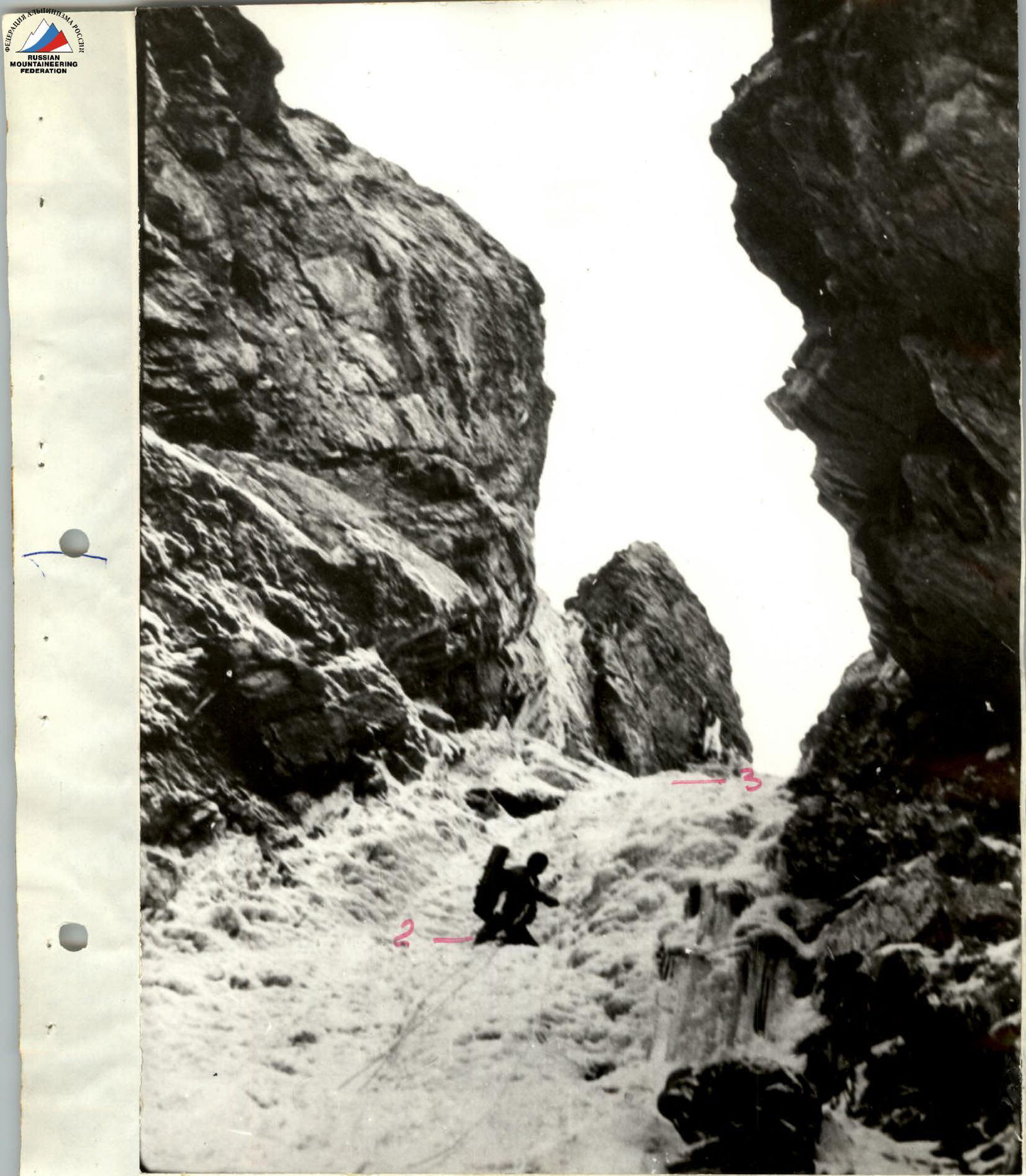 Photo 8. Section R2–R3. August 7, 1992, 9:00. "Smena-8M" camera. Height of shooting point — 4600 m. № of shooting point 1.
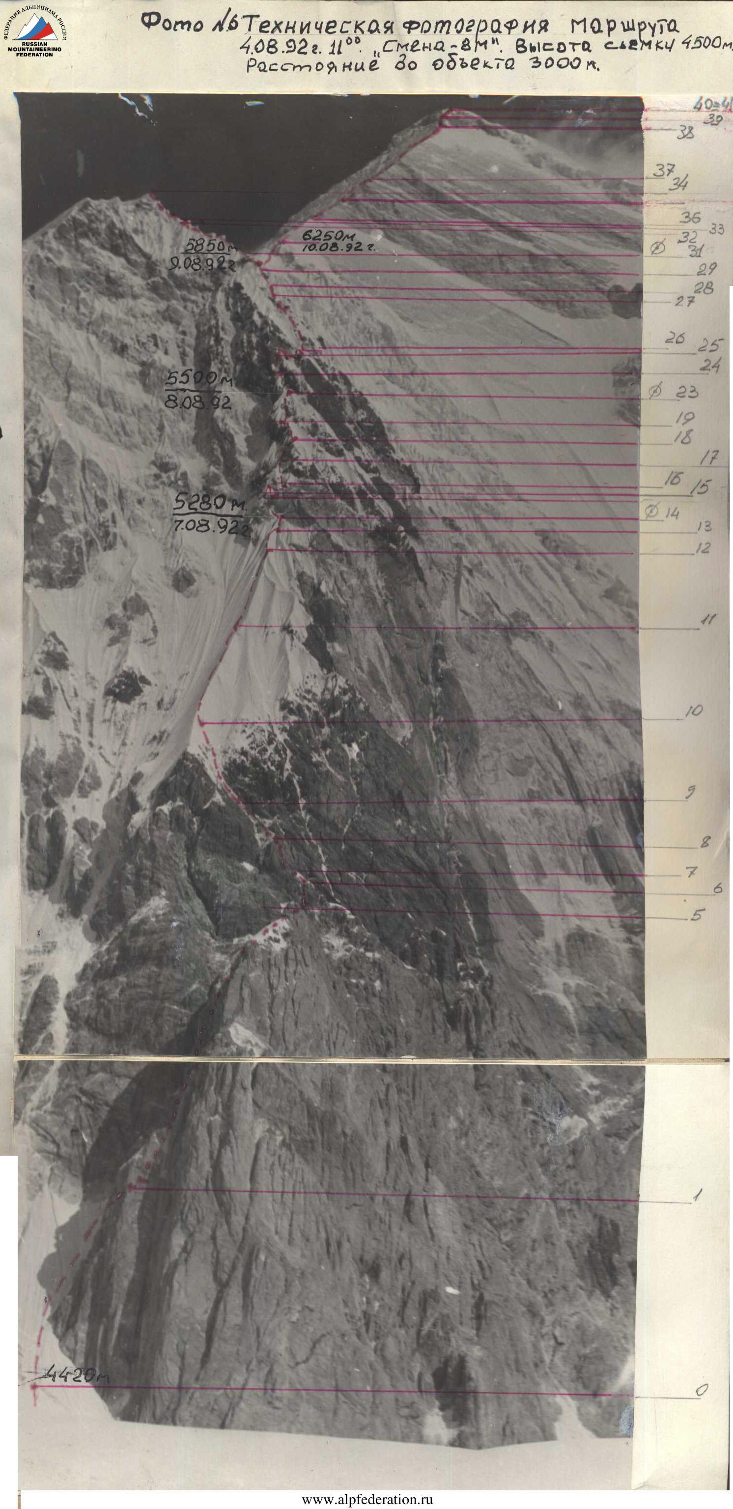
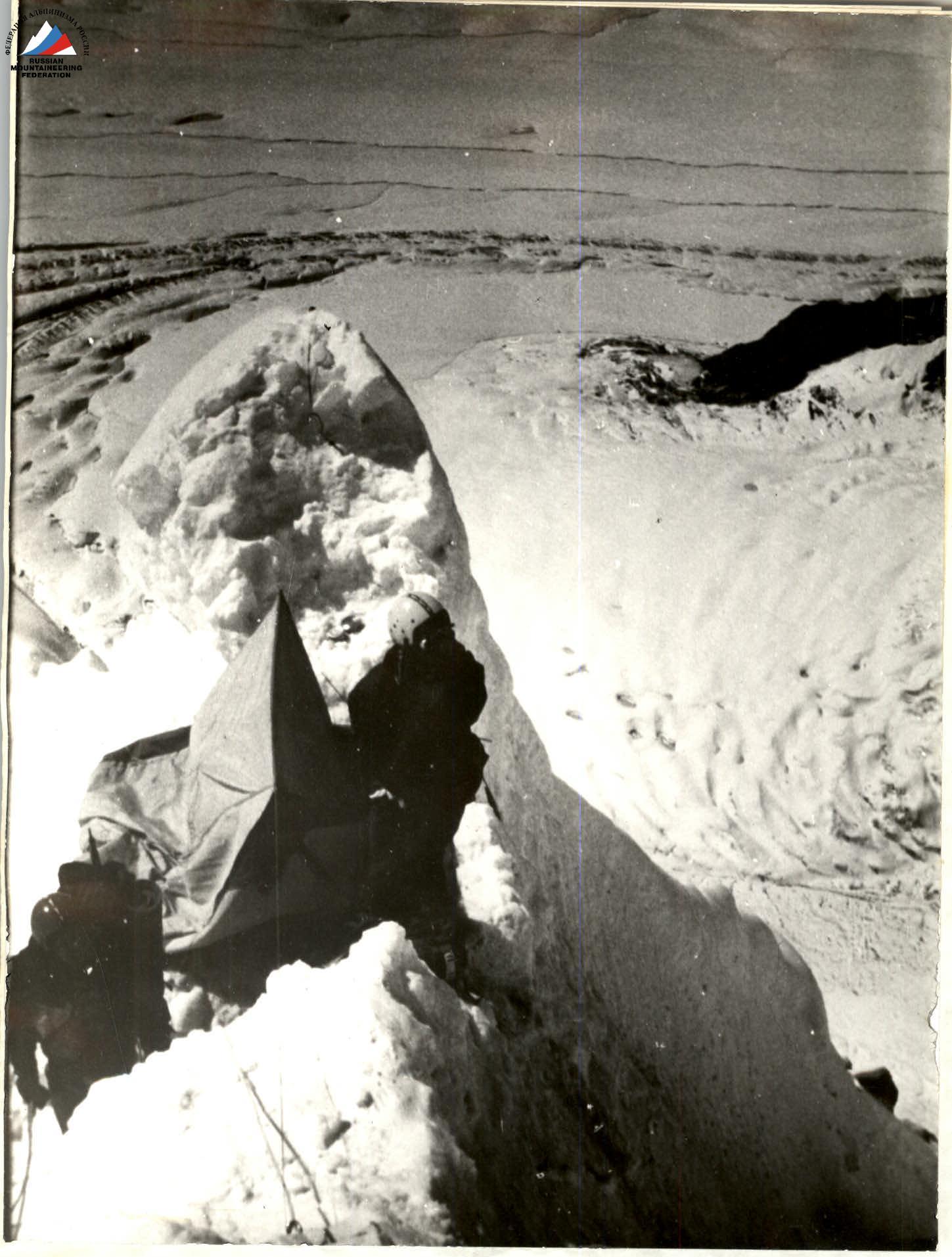 Photo 9. Overnight stop №I. August 8, 1992, 10:00. "Smena-8M" camera. Height of shooting point — 5280 m. № of shooting point 2.
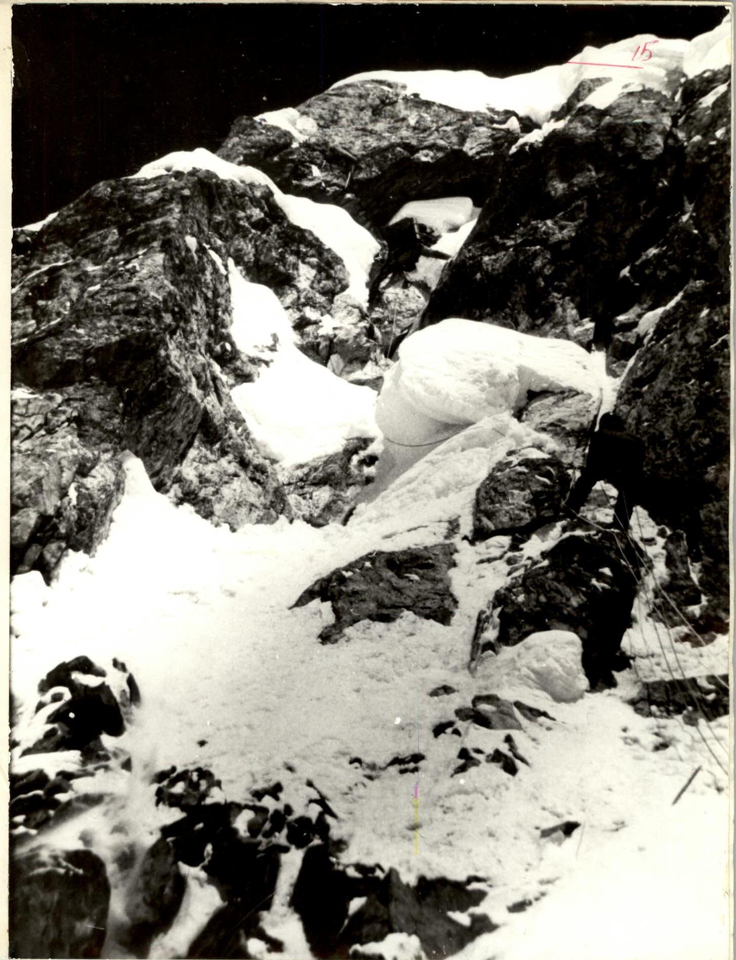 Photo 10. Section R14–R15. August 8, 1992, 10:00. "Smena-8M" camera. Height of shooting point — 5280 m. № of shooting point 3.
 Photo 11. Section R16–R17. August 8, 1992. "Smena-8M" camera. Height of shooting point — 5350 m. № of shooting point 4.
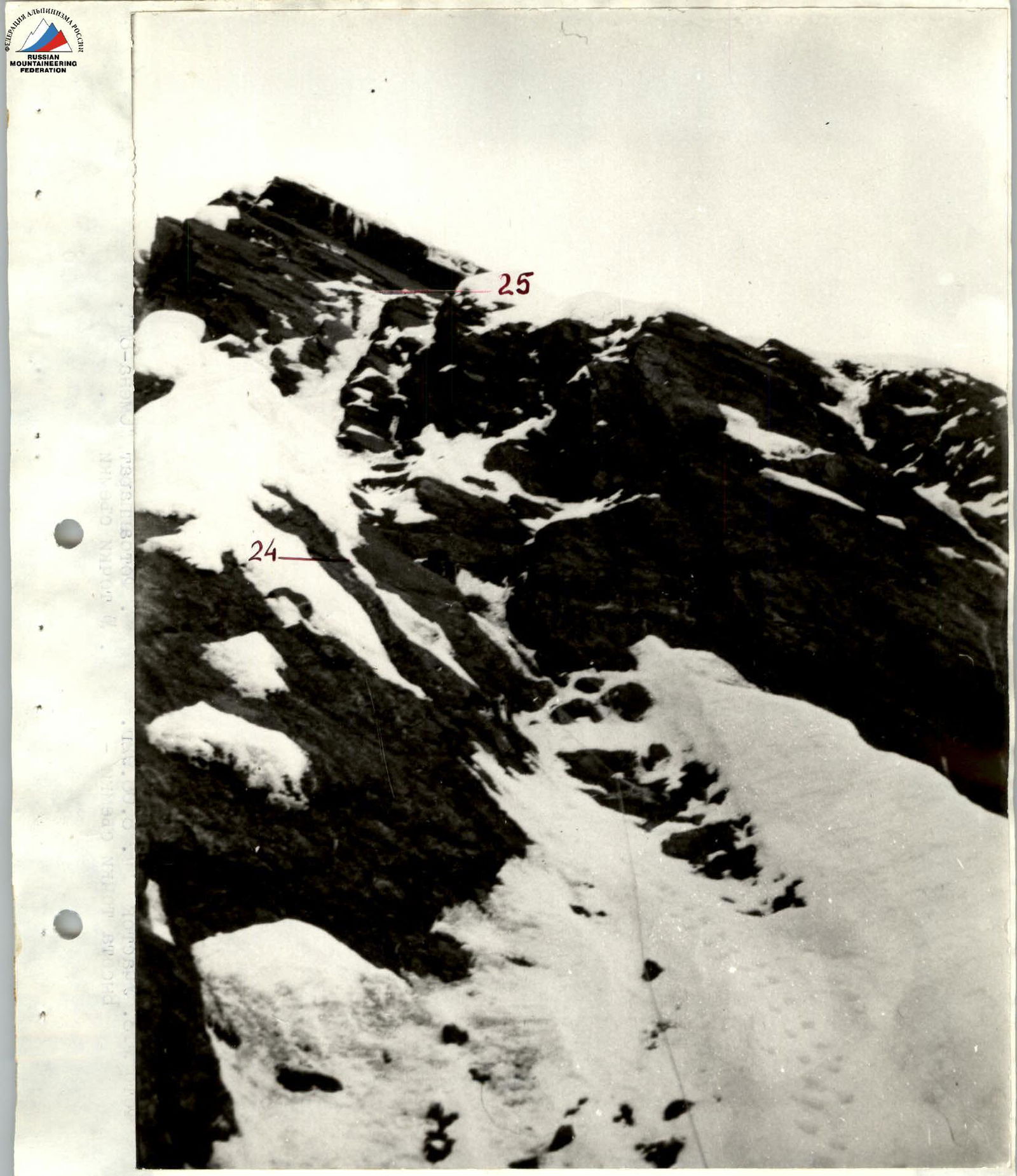 Photo 12. Section R23–R25. August 8, 1992. "Smena-8M" camera. Height of shooting point — 5500 m. № of shooting point 5.
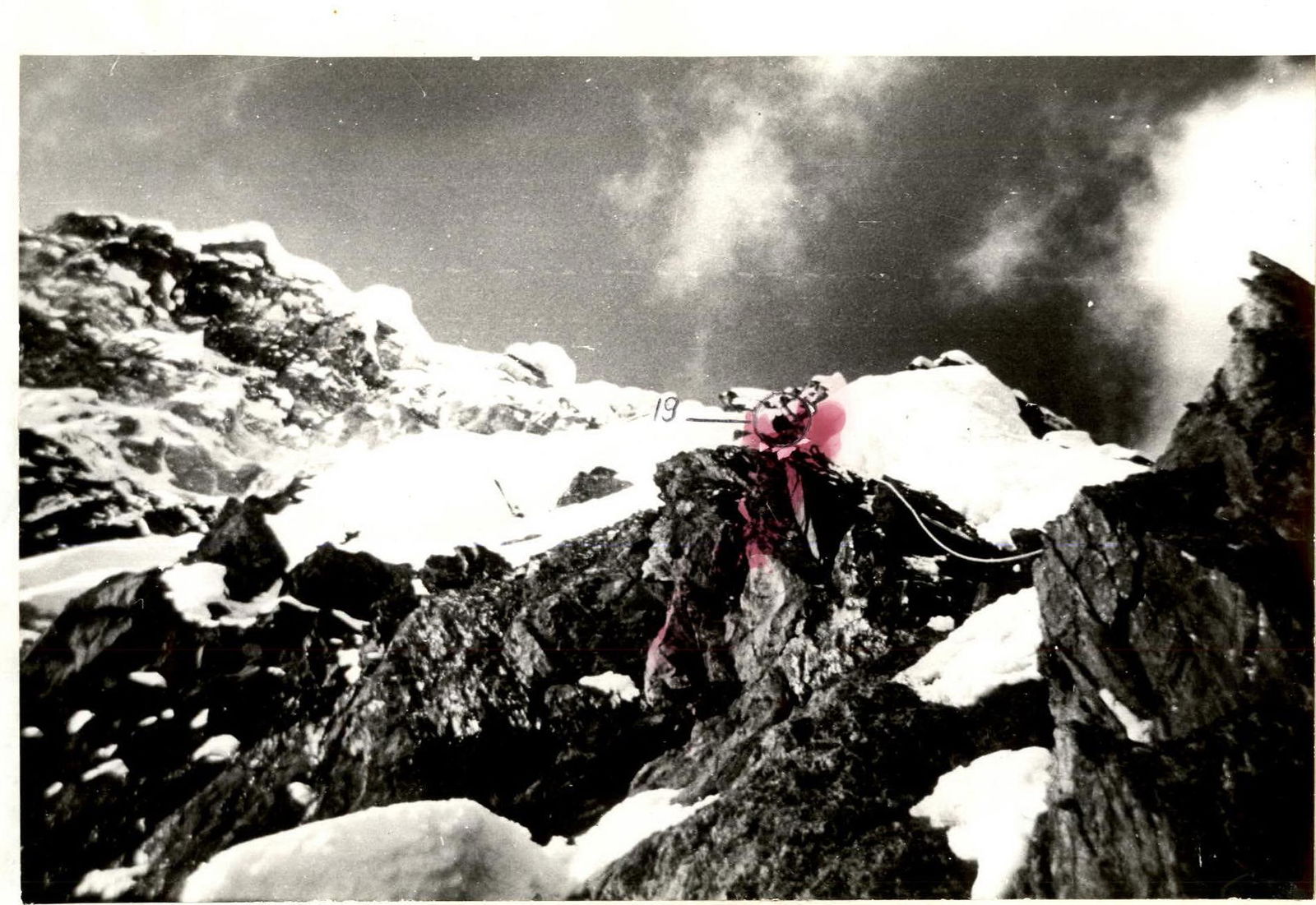 Photo 13. Section R18–R19. August 8, 1992. "Smena-8M" camera. № of shooting point 6.