Ascent Passport
- Ascent area — Central Tien Shan, Tengri Tag ridge, South Inylchek glacier, number according to the 1999 classification table —.
- Peak name: Khan Tengri (6995 m), route name: via NW edge from Chapayev peak shoulder (I. Grebenshchikov).
- Complexity category: 5A category.
- Route type — combined
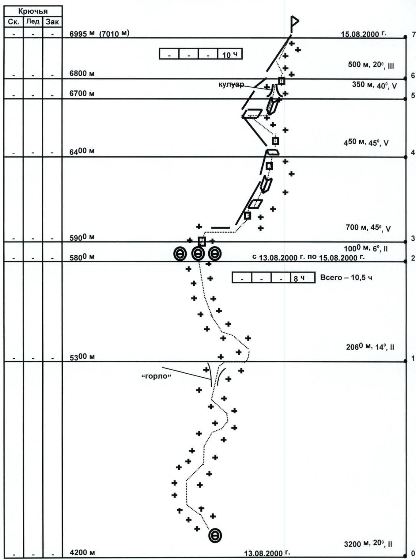
- Route elevation gain: 2800 m (by altimeter); route length — 8260 m; sections of 5th category — 1500 m; 6th category —. Average steepness: main part of the route 43° entire route 20°
- Pitons used on the route: rock — none, ice — none, chocks — none, snow stakes — none
- Total climbing hours — 30.5 h, days — 4
- Number of bivouacs and their characteristics: total 3 bivouacs, all in a cave at 5800 m
- Group leader: Petrov Andrey Evgenyevich, Candidate Master of Sports. Group member: Odokhovsky Vyacheslav Veniaminovich, 1st sports category. Group observers: Zueva T.A. — Candidate Master of Sports, Master of Sports. Komarov S.A. — 1st sports category.
- Group coach: Khokhlov Yuri Vladimirovich, Master of Sports Departure to the route at 3:30, August 13, 2000. Summit at 16:00, August 15, 2000. Return to base camp at 11:30, August 16, 2000.
- Organization — Moscow Federation of Mountaineering and Rock Climbing
Sheet 3, p. 5
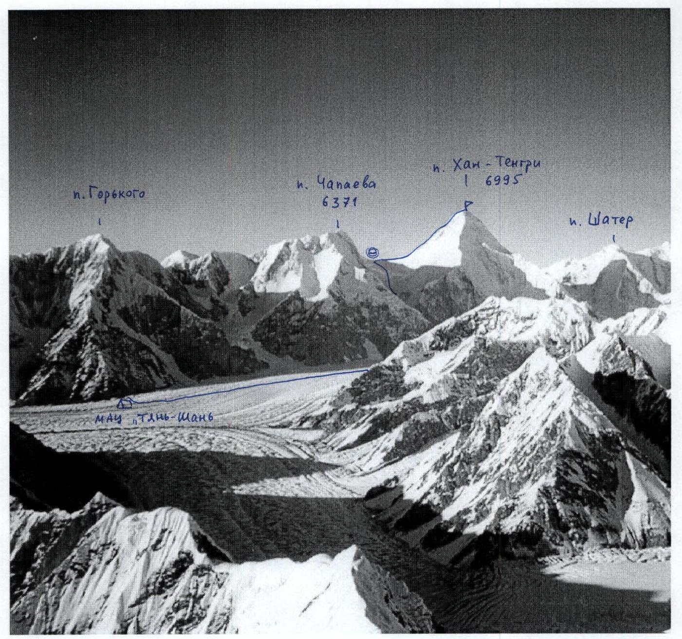
Photopanorama of the ascent area. Photo by V. Odokhovsky from the ridge of Peak Pobeda, 6200 m, August 16, 1999.
UIAA ROUTE DIAGRAM
Khan Tengri, 6995 m
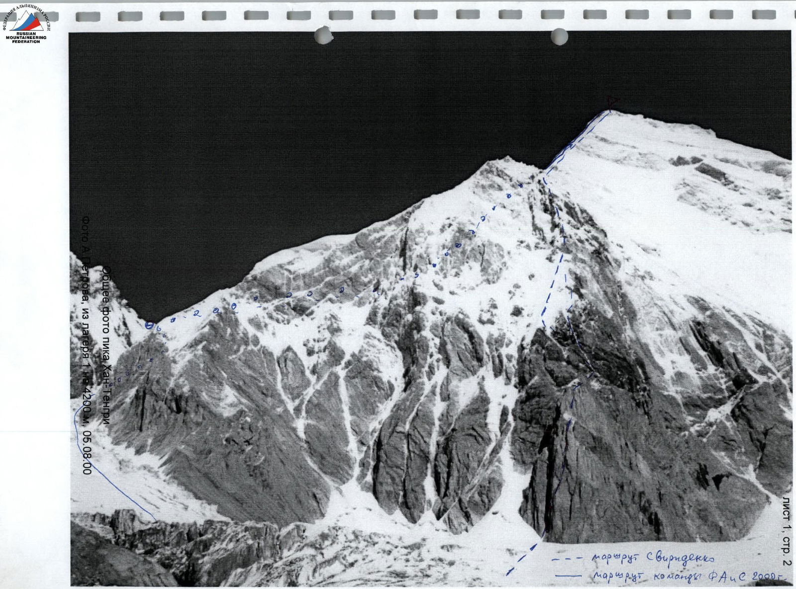
Technical photograph of the route. Photo by A. Petrov from camp 3 (cave at 5800 m), August 7, 2000.
Preparation for the Ascent
The group members in the same composition made an ascent to Peak Pobeda in 1999 and considered traversing this massif as one of the options for 2000. The participants were part of the reserve team of the Moscow Federation of Mountaineering and Rock Climbing for the Everest ascent in spring 2000, but the main work did not allow them to participate in such a long expedition. Nevertheless, they conducted a sufficient amount of training work; both participated in ski marathons "Lyzhnya Rossii", "Moscow Lyzhnya", and two stages of the Erokhin race; in addition, A. Petrov completed the marathons: March Longa (70 km, Italy), Bitsevsky, Engadin (Switzerland), and Prazdnik Severa (Murmansk). They studied materials and received consultations on the routes in the area from participants of first ascents. V. Odokhovsky received consultations and photographs on the traverse of Peak SAVO — Pobeda Zapadnaya (Vazha Pshavela) from V. Zasetsky — this is the route of V. Glukhov (1972), which was not repeated. The group arrived at the base camp on the South Inylchek glacier — the International Mountaineering Center (IMC) "Tien Shan", head N.N. Shchetnikov, on August 2, 2000. The group made two reconnaissance exits:
- to the camp at 4200 m;
- towards the Diky and Proletarsky Tourist glaciers.
For acclimatization, they made an ascent to Khan Tengri, as the most convenient object in the area for gaining altitude, although it is dangerous due to the Semenovsky glacier. After overnight stays in the 4200 camp, 5200 camp, they reached the col at 5800 m, set up a cave. After the overnight stay, they felt normal, the weather was good, so they made an ascent up the Khan Tengri ridge. During the exit, they participated in the search for a group member from Minsk who had fallen the day before during the descent. This was done at the request of the members of this group, but they were unable to indicate on which side of the ridge he had fallen. Later it became known that it was the leader of the Minsk group, Nikolai Konopelko, and his body was found the day before by participants of other gatherings on the slope, at an altitude of about 6100 m. By 12:00, they managed to climb to an altitude of 6500 m, above the site with memorial plaques at 6400. On this site lay:
- a camouflage jacket
- a green ski hat which obviously belonged to the deceased. The group descended and spent the night in the cave. Early in the morning of August 9, the group descended to the base camp. At night, in the absence of wind, snowfall began, which continued for a day. About one meter of snow fell. Groups from the 4200 m camp took more than ten hours to reach the base camp (instead of 2 hours). Unlike previous years, this snow did not melt until the end of the expedition, and snowfalls continued. The avalanche danger in the area increased overall. In these conditions, the exit to the traverse of Pobeda along the planned route became objectively dangerous both at the approach stage (23–25 km from IMC "Tien Shan") and during the ascent. It was decided:
- to attempt to ascend Khan Tengri, the condition of which was known to the participants.
- to improve altitude training before the traverse (if the snow situation changes during this time).
- to fulfill the backup option of passing the route within the framework of the application for the Russian Championship.
The participants had experience of ascending Khan Tengri in 1995 (Odokhovsky — to the summit, Petrov — to 6400 m). Consultations were received from:
- N.N. Shchetnikov,
- S.F. Klovanich,
- A.A. Gerasimov.
Of course, the beautiful pyramid of Khan Tengri is always the best incentive for an ascent.
Tactical Ascent Plan
The group's actions on the route were determined by the tactical ascent plan. When drawing up the plan, the following were taken into account:
- poor weather conditions in the area,
- the state of the route in the current season,
- changes in its condition immediately before the ascent,
- the condition of the walls above the Semenovsky glacier in the corridor called the "mousetrap",
- the physical condition and acclimatization of the ascent participants.
Overall, the tactical plan consisted of the following:
First day — from the base camp, ascend to the col between Chapayev peak and Khan Tengri peak at an altitude of 5800 m. According to the tactical plan, the largest altitude gain is made on this day, which is about 1800 m. It was planned to divide it into two parts:
- a night exit and approach to the 4200 camp by dawn.
- ascent to 10:30 to the 5200 camp, where lunch and rest, and then in the second half of the day, ascent to the 5800 col for an overnight stay in the cave prepared during acclimatization.
The physical preparation of the participants, the even distribution of the load for gaining altitude during the day, and the acclimatization carried out ensured the possibility of performing such work without overload.
The second day according to the tactical plan — ascent to Khan Tengri peak via the northwest ridge and descent to the cave on the col. According to the tactical plan, this day should be the most intense in terms of physical load. Prolonged work required the use of the full daylight and good weather. In case of worsening weather, it is necessary to provide for the possibility of overnight stay on one of the sites on the ridge, which we saw during the acclimatization exit. It was decided to:
- throw a tent onto a site at an altitude of 6400 m.
Possible scenarios for the development of events:
- With good health and good weather — ascent to the summit and descent to the cave.
- With poor health or worsening weather (weather often deteriorates in this area in the second half of the day) — descent to an altitude of 6400 m for an overnight stay on the route.
Route features:
- The rock part of the NW ridge is "littered" with old ropes of previous climbers (a kind of markers).
- All this made it possible to conclude that descent along the ridge is possible even in poor weather conditions.
The third day according to the tactical plan — descent from the col to the base camp according to the group's health and weather conditions. The need to descend early in the morning was taken into account in order to pass the Semenovsky glacier at a safe time. Thus, the tactical plan assumed the fastest possible passage of the route under normal weather conditions, which was fully ensured by the preparation of the participants. Taking into account the poor weather conditions in the area in general, and in the current year in particular, two reserve days are planned. For this, a supply of food and gas was provided. It is possible to wait out bad weather at the camps at an altitude of 4200 m, 5200 m, in the cave at 5800 m, as well as on the ridge on sites at an altitude of:
- 6000 m
- 6200 m (Petrov had already waited out bad weather here for 2 days in 1995)
- 6400 m
- 6550 m.
Ascent Description
Day 1. August 13, 2000
Departure from the base camp on the moraine under Peak Gorky at 3:20. The South Inylchek glacier was traversed in the dark along a trail in deep snow, beaten after the snowfalls of the previous days. In the middle part, where it is necessary to cross more than 20 crevasses on the bend of the glacier, the trail winds strongly between snow bridges. In the upper part, when approaching the moraine, the rivers are also covered with snowfalls. Since the South Inylchek glacier was closed, movement was carried out in rope teams along the center, but closer to the right (orographic) part, where the path was already fairly well known. At 5:50, when it got light, the group reached camp 1 at an altitude of 4200 m in the upper part of the South Inylchek glacier moraine, which begins under the slopes of Chapayev peak and ends under the tongue of the Semenovsky glacier. After a snack with hot tea from flasks on the belt, the group began to ascend the slope of the Semenovsky glacier at 6:00. After the snowfall, many crevasses were closed, but the bridges remained. A group of tourists from Moscow was ascending ahead of us, as well as a group from Minsk, who were going to search for the body of the deceased. The upper part of the wall of Chapayev peak with a hanging glacier was in clouds and was not heated by the rising sun. We caught up with both groups at the end of the ascent and together entered the narrow part of the passage between the walls of Chapayev on the left and the slopes of Khan Tengri on the right — the throat of the Semenovsky glacier, the beginning of the "mousetrap". At 8:45, when we were exiting the throat, an ice fall occurred from the hanging glacier of Chapayev peak. At such a time, ice falls had not been noted before by either participants or consultants. While the blocks were falling along the wall, the participants quickly moved up and away from the expected fall. Then they turned their faces away from the flow, dropping the loops of their poles and backpacks and making a ring with their hands in front of their faces to create a "bag" for breathing in case of being covered with snow. According to estimates, the movement of the main ice flow should have passed below the location of the group. That's how it happened, but the shock wave and snow whirlwind covered the upper part of the chain of people, and the flow of ice debris — the lower part. One of the tourists was covered with snow. We helped to dig him out and provide first aid. He had severe skin abrasions on his head. The bleeding was stopped. The participant was able to move independently, and the tourists decided to go down. Our help was not required. We assessed the situation and decided to go up. There were no more ice falls, the weather was deteriorating, and at 10:00, when we reached the slope under camp 2, it started snowing, and a blizzard began. From 10:30 to 13:00, we waited out the bad weather in a tent in camp 2. At 13:00, the blizzard subsided somewhat, the weather improved, and we went up. We ascended the slope of the snowy valley and reached the col at 16:30, settling in "our" cave. The ascent was safe, but the blizzard continued, visibility was limited, the trail was almost completely covered, so we had to make a trail, and therefore we ascended for 3 hours 30 minutes, although during acclimatization we managed in three hours.
Day 2. August 14, 2000
The whole day was bad weather. We spent the day in the cave at an altitude of 5800 m — quite comfortably. Snow and wind were covering the entrance, so we had to dig it out. By evening, the weather improved, the snowfall stopped. It was decided to go out for the ascent in the morning.
Day 3. August 15, 2000
The ascent was early, in the dark. Departure at 5:30. During the ascent, on sections R2–R5, the weather was good, although it was windy and frosty. At 6400 m, a group from Slovenia decided to go down due to the risk of frostbite on their feet. The rocks were heavily snowed, which complicated the movement. By noon, we were at 6500 m, the lower part was covered with clouds coming from the direction of Pobeda. The sun came out in the couloir, there was no wind here, but it got hot, and we had to undress. On the ridge above the couloir, there was a strong wind. The ascent to the dome went through deep snow. Movement was in a rope team simultaneously, with insurance through an ice axe. At the summit at 16:00. Strong wind, no notes in the trig point or around it. Clouds were below us. Descent was with insurance through ledges and ice axe. We used our own rope as insurance and sometimes used fixed ropes for descent. At the end of the descent along the rocks, when exiting onto the col, we were caught in clouds, and a blizzard. There were no tracks, it was getting dark, and we had to use headlamps. However, here the movement was already horizontal, which did not present technical difficulties. At 20:00, we were in the cave.
Day 4. August 16, 2000
The whole night the wind was blowing, and there was a blizzard. By morning, the snowfall had stopped, but the wind was blowing snow along the slope. We started descending at 6:00. The blizzard was such that it managed to cover the tracks of the leader. By the time we reached camp 2, the blizzard had stopped, and the wind had died down here. By 9, we were already below the throat. The walls were silent. At 9:30, we were on the glacier, where the sun was shining, and we undressed. A group of Moscow tourists was still here. The injured person was moving, although with difficulty. In 2 hours, we were at the base camp. In the evening, it snowed again. Then the weather improved, and on August 18–19, we made exits in the direction of Peak Pobeda and down the South Inylchek glacier. The condition of the slopes and snow cover on the glacier showed that the exit to the main route was practically not feasible. The approaches (23–25 km) required trail-breaking, and the slopes were avalanche-prone. On August 20, we took a helicopter at 10:00 and flew to Inylchek settlement.

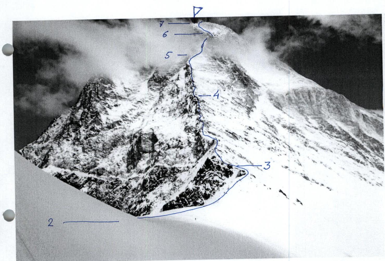
Pre-summit tower of Khan Tengri. Sections R4–R6. Photo by A. Petrov, August 15, 2000, from an altitude of 6500 m