I. Ice and snow class
- Central Tien Shan, Tengri Tag ridge
- Sovetskoi Kirgizii Peak (5660 m) via the center of the North-East face, ice and snow route
- Proposed — 6A category of difficulty, first ascent
- Elevation gain: 1310 m, length — 1560 m
Length of 5–6 category of difficulty sections — 1260 m. Average steepness of the main part of the route — 61° (4350–5605), including 6 category of difficulty sections at 65° (5157–5193, 5330–5357); 80° (5054–5098, 5357–5401)
- Pitons hammered in:
| Rock pitons | Nuts | Ice screws | Boulder bolts |
|---|---|---|---|
| 13 | 9 | 270× | 0 |
× — excluding ice screws used by two teams during parallel movement
- Team's total climbing hours: 15, days — 1
- Overnights: 1st–2nd on the ridge after the summit
- Leader: Tumyalis Vladimir Vitalius, Master of Sports Team members:
- Kozhemyako Nikolai Grigorievich, Master of Sports
- Plotnikov Ivan Alexandrovich, Candidate for Master of Sports
- Stalkovsky Vladimir Viktorovich, Candidate for Master of Sports
- Tenenev Valentin Alekseevich, Master of Sports
- Shakleev Vladimir Ivanovich, Candidate for Master of Sports
-
Coach: Shevchenko Nikolai Alexandrovich, Master of Sports
-
Start of the route: July 30, 1989
Summit: July 30, 1989. Return: August 1, 1989
12. Organization — RSFSR State Committee for Sports
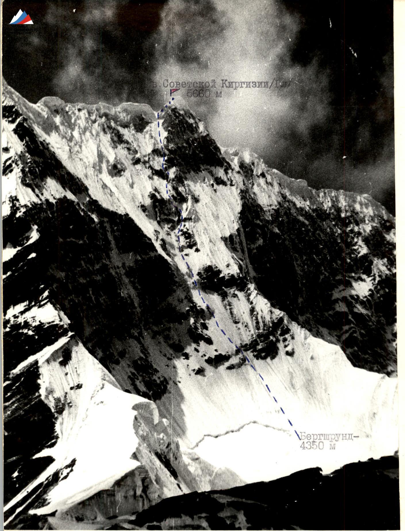
PHOTO #1. General photo of Sovetskoi Kirgizii Peak (main, 5660 m). Taken from the observers' camp on July 28, 1989 at 13:00. HELIOS-44-2 lens, 2/58. Distance 1.5 km, altitude 4130 m.
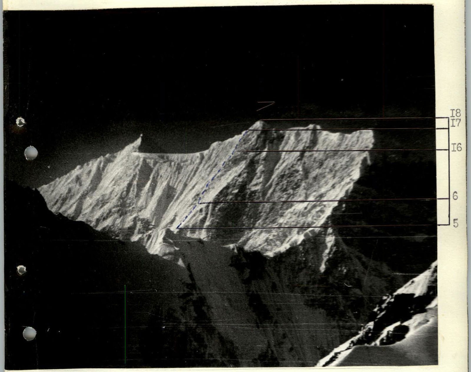
PHOTO #2. Right profile of the face. Taken from a helicopter on August 3, 1989 at 10:30. HELIOS-44-2 lens, 2/58. Distance 5 km, altitude 4500 m.
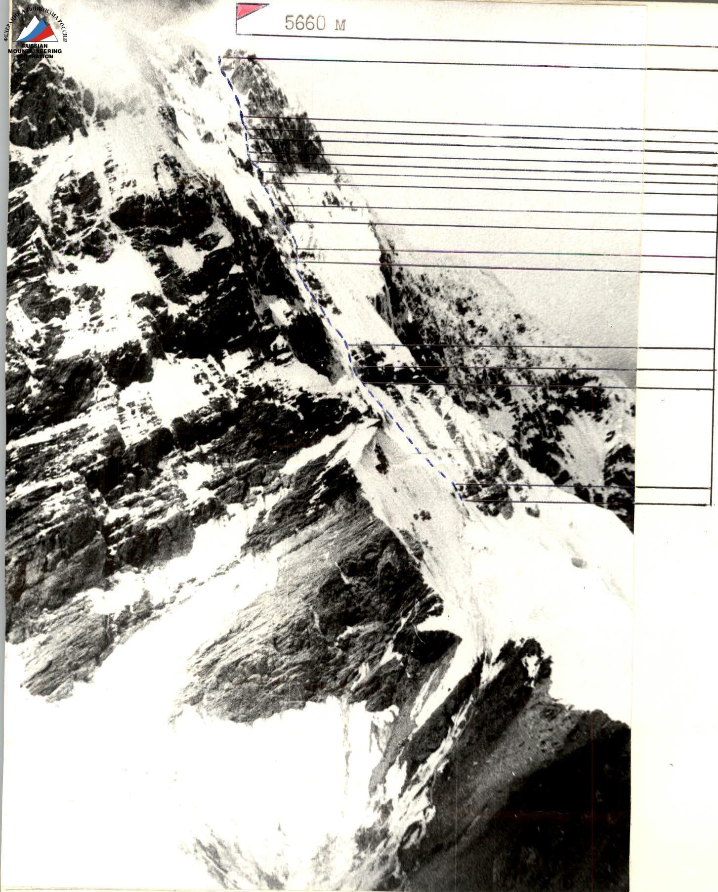
PHOTO #3. Left profile of the face. Taken from Sukhodolsky Glacier on July 30, 1989 at 13:00. HELIOS-44-2 lens, 2/58. Distance 1 km, point #2, altitude 4000 m. The North-East face of Sovetskoi Kirgizii Peak attracted climbers as early as 1974, but at that time it did not fit into any category. The ice and snow class rules of that year allowed this face to be submitted as a climbing objective in October 1988.
Preliminary observation and photography of the face were conducted by a group of four people dropped off by helicopter on July 11. Based on the reconnaissance results, two routes were chosen: the main option to the left peak of the face, and an alternate one — to the right. After being dropped off under the route and observing the face, the team settled on the right option as the most logical and safe. The route is almost entirely ice and fully meets the requirements of the ice and snow class.
The tactical plan was developed taking into account the specifics of the area, unstable weather conditions, especially in the second half of the day. A consultation was obtained from A. Tustukbaev, the first ascender of the South Peak of the Sovetskoi Kirgizii massif. The ascent schedule was quite strict and assumed a quick passage of the main wall section of the route.
The rocky outcrops of the upper part of the wall were considered problematic due to their being snow-covered and iced (sect. R10–R16, "letter C"). To ascend, in addition to ice screws, a suitable set of rock climbing equipment was prepared.
During preparation for the ascent, all safety measures were considered: an early start was planned, quick passage by parallel teams of the lower part of the wall, double rope movement, use of "8" descenders, Sticht plates, and UIAA ropes for belaying. Safe belay points and station organization under the cover of rocky outcrops were planned. Radio communication — three sessions a day; from 8:00 to 18:00 every hour — emergency listening by observers.
The team was provided with all necessary equipment and food. Specially sharpened ice screws with handles and quick draws were prepared, which had proven themselves well both on ice climbing and during a winter ascent in February of this year at the RSFSR Championship. To measure altitudes and determine the route's steepness, the team had:
- a pocket altimeter (made in Switzerland)
- a clinometer — level.
The team was formed based on performances at the USSR, RSFSR, and SA&VMF Championships in 1984–1988 from I8-SKA athletes and had extensive experience in joint ascents.
Over the course of a year, the core team members conducted joint training sessions with rock and ice climbing practice.
In February, a first ascent was made on the North face of Alamedinskaya Stena Peak (C).
During the training camp, physical and technical preparation standards were met, acclimatization hikes were made up to an altitude of 5900 m, and an ascent was made on Khan-Tengri via the South-West slope.
For the ascent period, a rescue team was formed together with the Tomsk Regional Sports Committee. The forward group was located directly under the route in the observation camp, consisting of:
-
- Foyt A.V. — head of rescue, Master of Sports, 3rd category
-
- Stalkovsky A.V. — doctor, Candidate for Master of Sports, 3rd category
-
- Drakin A.V. — participant, Candidate for Master of Sports, 1st category
-
- Shevchenko N.A. — team coach, Master of Sports, 1st category.
All were acclimatized, having made an ascent on Khan-Tengri. In the base camp were:
-
- Korzunin Yu.K. — deputy head of rescue, Candidate for Master of Sports, 3rd category
-
- Astakhov S.V. — participant, Candidate for Master of Sports
-
- Imaev R.I. — participant, Candidate for Master of Sports
-
- Chernyavsky A.V. — radio operator, 1st sports category
Everyone in the season had ascents of 5th category of difficulty.
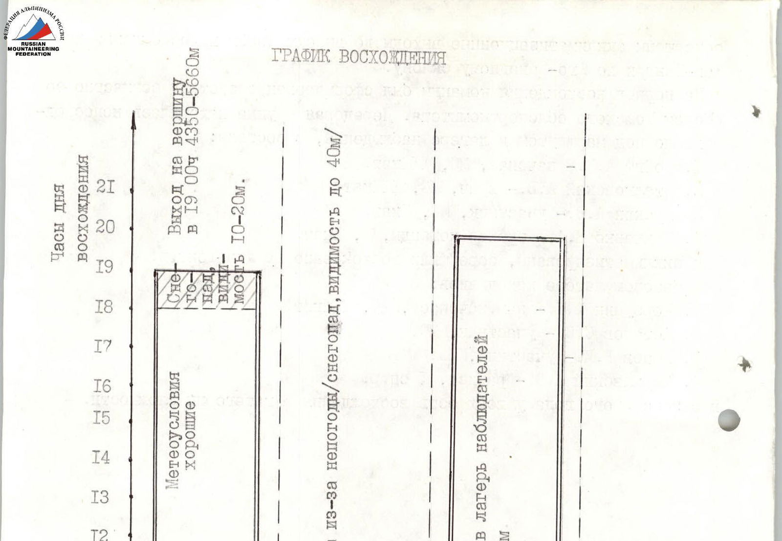
The first ascent of the North-East face of Sovetskoi Kirgizii Peak was made in one day, as planned by the tactical plan. The route line proceeded without deviations from the previously planned one.
It was planned to ascend in good weather in 12 hours, or in bad weather with a bivouac on the wall in 19 hours. The onset of bad weather in the middle part of the route (snow grains, visibility 10–20 m) complicated the path choice and slowed down the team's progress; participants got wet.
Further, the pace slowed down due to the passage of rocky belts in the upper part of the wall (sect. R10–R11, R14–R15, see photo #7):
- On sect. R14–R15, rocks were covered with dripped, refrozen ice, making it difficult to organize reliable belays.
- The section was climbed using rock climbing equipment.
The route took 15 hours to complete. The organization of team movement followed the tactical plan. On sections R0–R3, R4–R6, R16–R18, movement was by parallel teams (simultaneously). Work was alternating with a change of lead within the teams, belaying through ice screws, at a distance of 5–7 m. This tactical decision ensured a high speed of movement and contributed to safety, as it excluded the possibility of lower climbers being injured by dislodged ice.
Steep rock and ice sections were climbed with the organization of fixed ropes (sect. R3–R4, R6–R16, see photo #6):
- The first to work on these sections on a double rope were Plotnikov, Kozhemyako, Stalkovsky;
- Other participants moved on fixed ropes with belays.
During parallel movement, teams moved on a doubled rope (18 m). Each participant climbed about 35 m, half of it leading, then changing lead.
On difficult sections, there was interaction between teams.
For belaying the first climber, the following were used:
- "8" descender
- Sticht plate
- UIAA ropes
On ice terrain, stations were organized through two ice screws, on rock — two to three points, and in the lower and upper parts of rocks — use of ice screws.
The greatest difficulties during the ascent were encountered in the middle and upper parts of the route (sect. R6–R16).
For the first time, the team had to deal with:
- dripped, icicle-like ice with voids;
- areas where the ice crust had separated from the rock.
Passing such sections is psychologically very challenging, increasing the time needed to choose and organize reliable belays.
The rocky belts of the upper part of the route are strongly smoothed marble outcrops. Climbing is very challenging; the upper part was climbed using artificial climbing techniques (aid climbing). On sect. R14–R16, the leader's backpack was pulled up.
Food was planned at 0.6 kg per person per day, considering an alternate schedule in case of bad weather. In the morning and evening, hot meals were prepared; throughout the day, high-calorie pocket food and flasks with a drink.
For the ascent, a 6-person high-altitude tent was made, along with two down sleeping bags and special shock-absorbing loops. In case of a bivouac on the wall, a hammock was planned. In bad weather conditions during the ascent and during a bivouac, the team acted cohesively and in coordination. Overall, the route was climbed in a sporting style along the planned path.
Radio communication with observers was maintained three times a day, with emergency listening every hour. In case of failure to contact for two consecutive sessions or station failure, both the team and observers had flares.
Observers also had:
- binoculars
- 50x telescope
The forward rescue group was located directly under the route. There were no falls or injuries among the team; the route was climbed reliably, tactically, and technically correctly, with a reserve of physical strength. The bivouac site on the ridge was left in its original state; trash was packed and taken down.
TABLE OF FOOD AND FUEL.
| 1. Rusks | 1.0 kg | 12. Tea | 0.1 kg |
|---|---|---|---|
| 2. Buckwheat groats | 0.8 kg | 13. Sports drink | 0.5 kg |
| 3. Vermicelli | 0.4 kg | 14. Cookies | 0.6 kg |
| 4. Soups | 0.3 kg | 15. Canned fish | 0.9 kg |
| 5. Fried meat | 0.8 kg | 16. Raisins | 0.4 kg |
| 6. Lard | 0.5 kg | 17. Dried apricots | 0.4 kg |
| 7. Sausage | 1.0 kg | 18. Honey | 0.5 kg |
| 8. Cheese | 0.5 kg | 19. Dried milk | 0.8 kg |
| 9. Freeze-dried cottage cheese | 0.3 kg | 20. Walnuts | 0.4 kg |
| 10. Sugar | 1.0 kg | 21. Rosehip syrup | 0.3 kg |
| 11. Candies | 0.5.0 kg |
Weight of food in packaging — 12 kg. Gasoline 2.5 liters and stove fueling — 2.5 kg.
TOTAL: 14.5 kg
Weight of backpacks on the route is about 6 kg, excluding equipment in use.
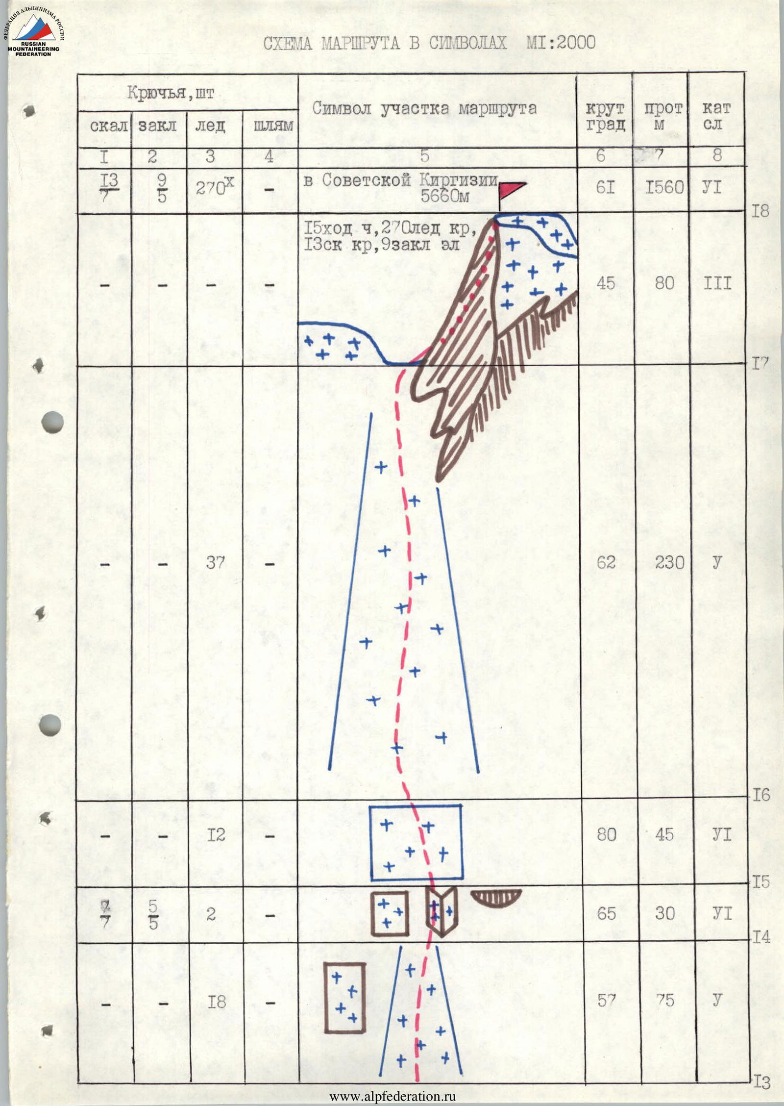
| Section | Rock pitons | Nuts | Ice screws | Boulder bolts | Steepness, ° | Length, m | Category of difficulty |
|---|---|---|---|---|---|---|---|
| R0–R1 | 28 | 48 | 220 | 4 | |||
| R1–R2 | 10 | 56 | 40 | 5 | |||
| R2–R3 | 30 | 52 | 200 | 5 | |||
| R3–R4 | 8 | 70 | 30 | 5 | |||
| R4–R5 | 12 | 58 | 60 | 5 | |||
| R5–R6 | 33 | 56 | 220 | 5 | |||
| R6–R7 | 12 | 70 | 40 | 5 | |||
| R7–R8 | 12 | 62 | 55 | 5 | |||
| R8–R9 | 13 | 80 | 45 | 6 | |||
| R9–R10 | 16 | 57 | 70 | 5 | |||
| R10–R11 | 6 | 4 | 4 | 65 | 40 | 6 | |
| R11–R12 | 10 | 60 | 40 | 5 | |||
| R12–R13 | 13 | 80 | 40 | 5 | |||
| R13–R14 | 18 | 57 | 75 | 5 | |||
| R14–R15 | 7 | 5 | 2 | 65 | 30 | 6 | |
| R15–R16 | 12 | 80 | 45 | 6 | |||
| R16–R17 | 37 | 62 | 230 | 5 | |||
| R17–R18 | 45 | 80 | 3 |
Route description by sections.
Section R0–R1. Start — bergschrund. It is better to cross the bergschrund in the right part as the width of the crevasse is somewhat smaller and there is a snow bridge. Further movement is along an ice slope with a steepness of up to 50°. Teams move in parallel, belaying through ice screws. Use of ice axe fis (ice axe protection device), possibly a combination of ice axe and fis.
Section R1–R2. First rocky belt, bypassed on ice to the left. For the first time, voids start to appear in the ice crust. Belaying and movement are similar to the previous section.
Section R2–R6. Two ice boards separated by a second rocky belt. Movement is alternating by parallel teams. Belaying through ice screws; everyone uses fis.
On section R3–R4:
- A steep dripped ice formation begins.
- In some places, the ice crust has separated from the rocks.
- Passage is quite challenging.
Here, interaction between teams was organized:
- The first climber went on a double rope.
- Belaying through ice screws.
- Use of fis.
- Others moved on fixed ropes with belays.
Section R6–R10. Central part of the rocky "cross" and exit under the lower part of "letter C". Passage is along ice between rocky islands. The ice is very steep, as on sect. R3–R4, with voids. On sect. R8–R9, up to 80° (see photo #6). Interaction between teams. The first climber on a double rope, belaying through ice screws, use of fis. Others moved on fixed ropes with belays.
Section R10–R11. Snow-covered rocky belt. Rocks are strongly smoothed, with holds mainly in the form of undercuts. Challenging climbing. The first climber moved on a double rope, belaying using rock climbing equipment (see photo #7). Others moved on fixed ropes with belays. A control cairn was left at the top of this section.
Section R11–R14. Steep ice brows. Interaction between teams. The first worked on a double rope using fis. Belaying through ice screws. Others moved on fixed ropes with belays.
On sect. R12–R13, very steep dripped, icicle-like ice with voids.
Section R14–R15. Rocky outcrop of the upper part of "letter C". Characteristics of the section:
- Rocks are strongly smoothed, with almost no holds
- Climbing is very challenging
- The first climber moved on a double rope
- Belaying using rock climbing equipment in aid climbing
- Others moved on fixed ropes with belays
Organization of belay station on the right part of the section under the cover of a rocky overhang.
Section R15–R16. Very steep ice, flowing practically like a waterfall with icicles. The main ice crust, up to 15 cm thick, is separated from the rock. Passage of the section is very challenging; in places, the crust is pierced by fis. Additionally, choosing and organizing reliable belays is complicated.
- The first worked on a double rope with fis
- Belaying through ice screws
- Others on fixed ropes with belays
Section R16–R17. A fairly wide ice board leading to the pre-summit.
Lower ridge. Alternating movement by parallel teams. Belaying through ice screws.
Section R17–R18. Snow ramp leading to the summit cap. Snow is very hard, firn. Simultaneous movement, belaying through ice axes. A cairn was left on a rocky outcrop near the summit.
Throughout the entire route, the team wore crampons.
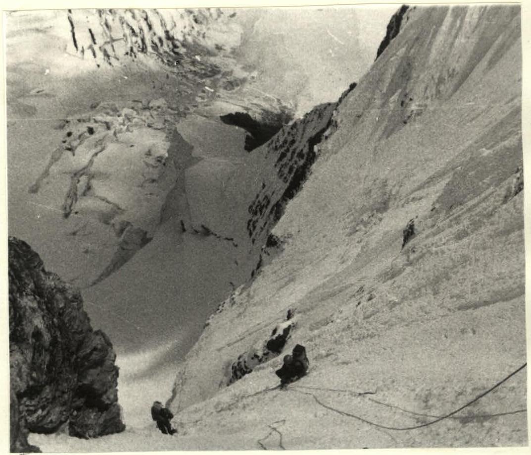
PHOTO #6a. Team working on section R9–R10. Taken on July 30, 1989 at 12:00. T-43 lens, 4/40.
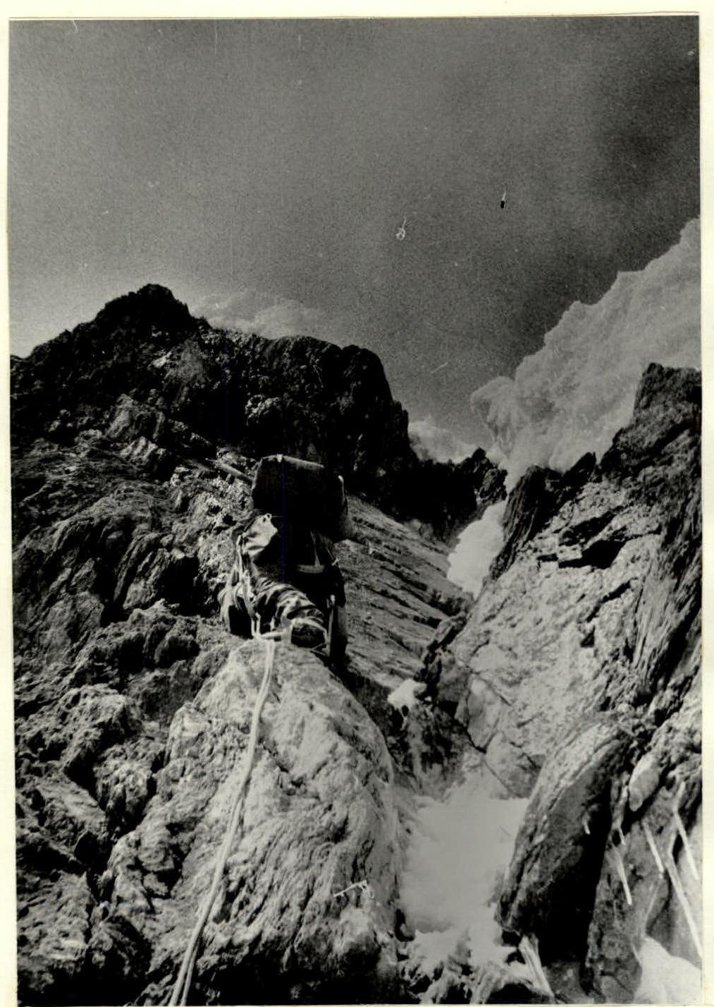
PHOTO #7. Stalkovsky V.V. working on section R10–R11. Taken on July 30, 1989 at 13:00. T-43 lens, 4/40.