
Russian Mountaineering Championship
High-Technical Class
2022
Report
on the ascent to the peak Korolyova, 5816 m, via the center of the North Face 6B cat. diff. (tentative), first ascent by a combined team from Krasnoyarsk Krai and Perm Krai July 20–23, 2022
| 1. General Information | ||
|---|---|---|
| 1.1 | Full name, sports rank of the leader | Parfenov A.A. (MS) |
| 1.2 | Full name, sports rank of participants | Mukhametzyanov R.N. (MS), Oleneva N.A. (MS) |
| 1.3 | Full name of the coach | Zakharov N.N. (MSMK), Balezin V.V. (MSMK) |
| 1.4 | Organization | Krasnoyarsk Krai Mountaineering Federation, PKDMOO FAiS |
| 2. Characteristics of the Ascent Object | ||
| 2.1 | Region | West Kokshaal-Too |
| 2.2 | Valley | Chon-Turasu Valley |
| 2.3 | Section number according to the 2013 Classification Table | 7.5 |
| 2.5 | Geographic coordinates of the peak (latitude/longitude), GPS coordinates | N41.080878 E77.767928 |
| 3. Characteristics of the Route | ||
| 3.1 | Route Name | Via the center of the North Face |
| 3.2 | Proposed Category of Difficulty | 6B |
| 3.3 | Degree of Route Exploration | First Ascent |
| 3.4 | Nature of the Route Terrain | Combined |
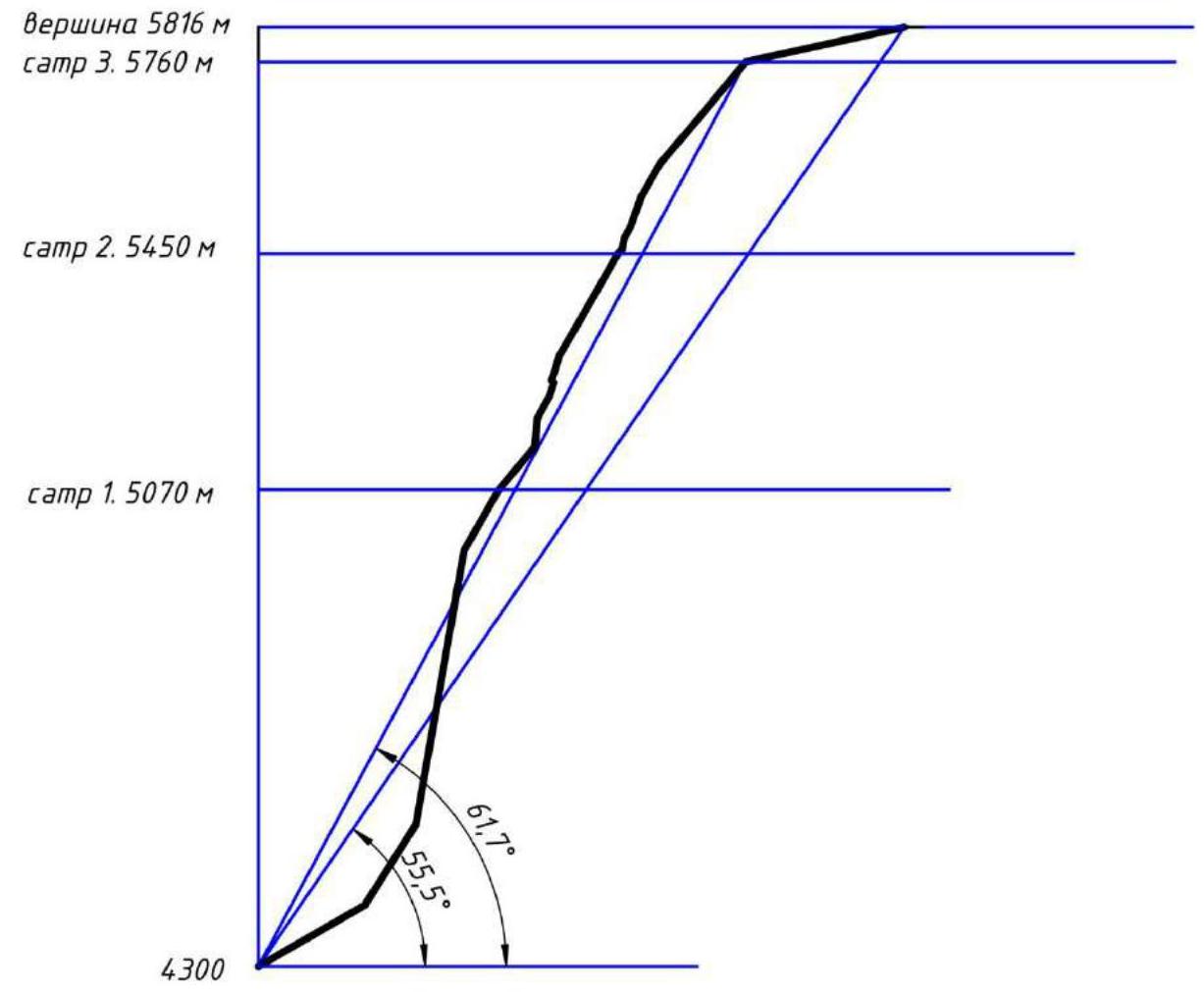
| 3.5 | Elevation Gain of the Route (altimeter or GPS data) | 1516 m |
| 3.6 | Route Length (in meters) | 2420 m |
| 3.7 | Technical elements of the route (total length of sections by category of difficulty, indicating terrain type: ice-snow, rock) | II–III cat. diff. — 790 m, IV cat. diff. — 655 m, V–VI cat. diff. — 821 m |
| 3.8 | Average Steepness of the Route, (°) | 55.5° |
| 3.9 | Average Steepness of the Main Part of the Route, (°) | 61.7° |
| 3.10 | Descent from the Summit | Via the Northwest Ridge (Temerev–Belotserkovsky–Tyulyupo route), 23 rappels |
| 3.11 | Additional Route Characteristics | Safe from rockfall. Descent below the pass is hazardous in hot weather. |
| 4. Characteristics of the Team's Actions | ||
| 4.1 | Time on the move (team's moving hours, in hours and days) | 29 h, 3 days |
| 4.2 | Bivouacs | 1 — on a ledge, 1 — sitting on a ledge, 1 — on a ridge (during descent) |
| 4.3 | Time spent on route processing | 0 h, 0 days |
| 4.4 | Entry onto the Route | 5:00 July 20, 2022 |
| 4.5 | Reach the Summit | 14:20 July 22, 2022 |
| 4.6 | Return to ABC | 22:00 July 23, 2022 |
| 5. Characteristics of Weather Conditions | ||
| 5.1 | Temperature, °C | –5…+5 °C |
| 5.2 | Wind Speed, m/s | Up to 10 m/s |
| 5.3 | Precipitation | — |
| 5.4 | Visibility, m | Clear |
| 6. Responsible for the Report | ||
| 6.1 | Full name, e-mail | Parfenov A.A. patriodemoerte@mail.ru |
II Description of the Ascent
1. Characteristics of the Ascent Object
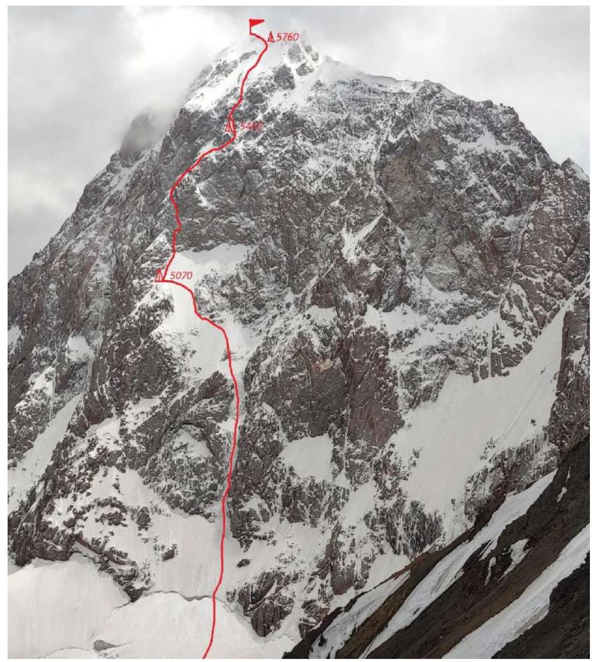
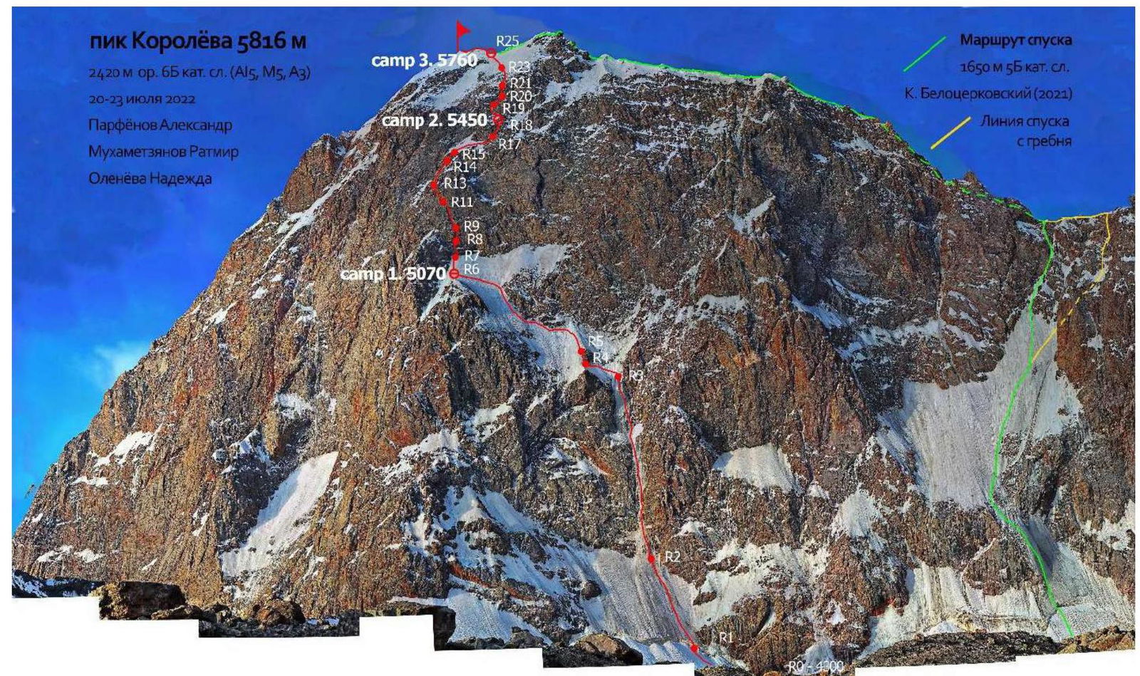
1.1. General Photo of the Peak
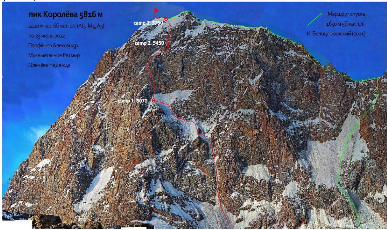
The route taken by the team.
1.2. Photo of the Route Profile
1.3. Drawn Profile of the Route
1.4. Photopanorama of the Area

Panorama of the Korolyova massif
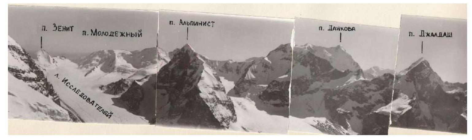
Photopanorama of the main peaks of the Researchers Glacier (Chon-Turasu Glacier)
1.5. Area Map
West Kokshaal-Too is the southernmost ridge in Kyrgyzstan. This ridge is located in the Central Tian Shan between Lake Issyk-Kul and the Takla-Makan Desert, on the border between Kyrgyzstan and China. To the north, the Kokshaal-Too ridge borders the Uzengy-Kuu and Myudryum rivers, and to the south, the Kokshaal River.
This area has many peaks with heights around 6000 m. The most interesting among them are: Peak Kyzyl-Asker (5842 m), Peak Krylya Sovetov (5800 m), Peak Shmidt (5954 m, also known as Cosmos), Peak Dankova (5982 m), Peak Chon-Turasu or Joldash (5729 m), Peak Alpinist (5641 m), and Peak Sergei Korolyova (5816 m, also known as Turist). The area is characterized by a combination of typically Alpine forms (many vertical rock walls with a height difference of about 1.5–2 km) and vast glaciation, second only to the area around Peak Pobeda in Tian Shan. The entire area, including lowlands, is a zone of permafrost. Marshy areas are often found up to elevations of 4000 m.
The snow line is at an altitude of about 4000–4500 m above sea level. River valleys have high absolute heights of about 3000–3500 m above sea level. The climate in the valley is harsh. The average monthly temperature in summer is around 5–8 °C, with unstable weather.
I (Alexander Parfenov) was already in this area in 2016. Then, two teams from Krasnoyarsk climbed routes 6A on Great Wall of China and 6B on Kyzyl-Asker. Since then, several teams have visited Kokshaal-Too, mainly in the valleys where Peaks Chon-Turasu and Shmidt (Cosmos) are located.
The Chon-Turasu valley, where Peak Sergei Korolyova is located, is the easternmost valley explored by mountaineers in West Kokshaal-Too. This valley is home to the highest peak in the area, Peak Dankova (5982 m), as well as attractive peaks for mountaineers: Alpinist, Chon-Turasu (Peak Joldash), and many smaller mountains. Previously, this area was visited several times by Moscow expeditions. They gave names to the main peaks in the area and climbed several routes up to 6A category of difficulty. Since then, several times, Kirill Belotserkovsky and his companions visited the area, and in 2021, the duo V. Koval–A. Gukov made a first ascent of Peak Shmidt with a complexity of 6B, naming it Peak Cosmos, rightfully as the first ascenders.
In Kirill Belotserkovsky's report, I was drawn to a photograph of the North Face of Peak Sergei Korolyova, which was unclimbed at the time. We contacted Kirill, and he kindly provided information on the approach and gave us the contact of tour operator Denis Plaksin from "Profi-Hunt". The approach starts directly from Bishkek. At the airport, we were met by a jeep that took us to a hostel so we could make purchases. The journey to the base camp in the Chon-Turasu valley takes approximately 15–18 hours or 380 km. The last major settlement is Naryn; here, you can still find all the amenities of civilization: cafes, internet, and so on. The last 7 km of the 380 km required us to walk with horses, as the far bank of the river in the Chon-Turasu valley had collapsed (or so we were told), but these are just details. The clearing where the approach ends is the closest comfortable and non-marshy place to stay; further on, moraine ridges begin, and then the glacier itself. Generally, the area has flat, extremely long valleys. The glaciers are also flat, with minimal fragmentation, and you can approach the mountain in sneakers.
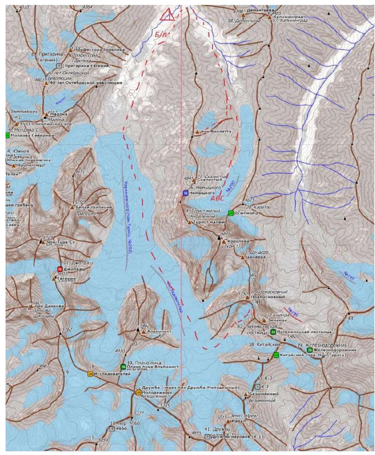
Area map. Dotted lines indicate the team's movements during acclimatization exits and the approach to the wall.
2. Characteristics of the Route
2.1. Technical Photograph of the Route
2.2. Route Diagram in UIAA Symbols
| UIAA Diagram | Length m. | Steepness gr. | Difficulty | ||||
|---|---|---|---|---|---|---|---|
| R26 | 250 | 20–50° | II | ||||
| R25 | 73 | 80° 95° | IV–V | ||||
| R24 | 200 | 50° | II | ||||
| R23 | 90 | 50° | II | ||||
| R22 | 4 | 60 | 50–70° | IV | |||
| R21 | 3 | 525 | 70° 70° | VI M5 | |||
| R20 | 2 | 4 | 827 | 60° 70° | IV M5 | ||
| R19 | 5 | 1018 12 | 50° 80° 60° | IV–V | |||
| R18 | 2 | 1 | 1 | 1515 | 60° 60° | M3 IV | |
| R17 | 4 | 30 | 60–70° | IV | |||
| R16 | 70 | 60° | III | ||||
| R15 | 4 | 3 | 30 | 50–70° | M5 | ||
| R14 | 3 | 60 | 60° | IV | |||
| R13 | 5 | 10317 | 70° 70° 75° | M5 V V | |||
| R12 | 7 | 1515 | 20° 70° | III M5 | |||
| R11 | 6 | 7 | 1566 | 70° 80° 70° 115° | IV V M5 A2 | ||
| R10 | 4 | 30 | 60° | IV | |||
| R9 | 3 | 5 | 15510 | 80° 75° 70° | A2–A3 VI IV | ||
| R8 | 3 | 6 | 30 | 80–90° | A2–A3 | ||
| R7 | 90 | 45° | II | ||||
| R6 | 6 | 300 | 60° | IV | |||
| R5 | 2 | 10 | 60° | III | |||
| R4 | 55 | 50° | III | ||||
| R3 | 121 | 450 | 70–90° | V | |||
| R2 | 11 | 2150 | 90° 55–60° | V VI | |||
| R1 | 200 | 30° | I | ||||
| R0 |
3. Characteristics of the Team's Actions
3.1. Brief Description of the Route Passage
| Section | Description | Photo No. |
|---|---|---|
| R0–R1 | 200 m snow slope, 30°, collection point and station in a snow-filled bergschrund. | Photo №1 |
| R1–R2 | 2 m, 90°, bergschrund, V; then 150 m, 55–60° ice, IV. | |
| R2–R3 | 450 m ice, 70–90°, sometimes resembling waterfall ice, V. Stations can be organized on ledges. | Photo №2, 3 |
| R3–R4 | 55 m, 50°, snow, traverse left to a rock ridge, III. | |
| R4–R5 | Up the rock ridge 10 m, 60°, III. No point in going left; it's more steep there. | |
| R5–R6 | Then 300 m left-up, 60°, snow and ice. Little protection; snow is deep on snowfields; belay only on ice outcrops. IV. At the end of the traverse, a convenient bivouac on a snowy ridge. | Photo №4 |
| R6–R7 | Up the snowfield to the start of rocks. 90 m, II. | Photo №5 |
| R7–R8 | Rock wall with poor relief, 30 m, 80–90°, artificial aid A2–A3. | Photo №6 |
| R8–R9 | Continuation of complex artificial aid along an indistinct internal angle, 15 m, A2–A3; then traverse right along a steep rock wall, 5 m, 75°, VI; 10 m up an internal angle, IV (70°). | Photo №7 |
| R9–R10 | Through a series of highly fragmented internal angles left-up, 30 m, IV (60°). | Photo №7 |
| R10–R11 | 15 m, IV; then 3 m frozen chimney, V; 6 m mixed internal angle, M5; then a section with a cornice, 6 m, 115°, A2. A slit under small rocks goes through the cornice. (70°). | |
| R11–R12 | 15 m traverse along a ledge III; then 15 m frozen internal angle, M5 (70°). | Photo №8 |
| R12–R13 | Frozen internal angle, 10 m, 70°, M5. Then traverse left through a rock bulge, 3 m, 70°, V, into an ice couloir, 17 m, 75°, V (73°). | |
| R13–R14 | Ice, 60 m, 60°, IV. | Photo №9 |
| R14–R15 | Frozen internal angle, hammer climbing, poor relief for belay, requiring great experience in placing protection points. 30 m, 50–70°, M5. | Photo №9 |
| R15–R16 | Traverse right, bypassing a rock bastion. Snow, ice, 70 m, 60°, III. | Photo №10 |
| R16–R17 | Move through a steep ice couloir into another ice couloir, and from there right-up the ice wall, 60–70°, IV. | Photo №10 |
| R17–R18 | Along a simple destroyed rock wall 15 m up, M3; then on ice left-up to the base of a rock wall, which serves as the edge of an ice couloir, 60°, IV. From the station, rappel onto an inclined ledge, which after prolonged construction work became suitable for a sitting bivouac. | |
| R18–R19 | Enter the ice couloir, 10 m, 50°, ice; then 18 m, 60–80° ice; 12 m, 60°, snow–ice, IV–V. | Photo №11 |
| R19–R20 | 8 m, 60°, snow+ice; then 12 m, 70°, internal angle filled with ice; further traverse under the rock left to the base of the next internal angle, 3 m, 70°, and 12 m, 70°, mixed internal angle. Complexity of the entire section is IV–V. | |
| R20–R21 | Along an inclined slab left 5 m, 70°; then a frozen internal angle 25 m, 70°, M5. | Photo №12 |
| R21–R22 | Snow-ice slope, 60 m, 50–70°, IV. | |
| R22–R23 | Snow-ice slope, 90 m, 50°, II. | |
| R23–R24 | Deep snow, no protection. 200 m, 50–60°, II. | Photo №13 |
| R24–R25 | Passage of a snowy cornice, exit to the ridge: 7 m, 80°; 3 m, 95°, IV–V. | Photo №13 |
| R25–R26 | Snow-ice ridge, 250 m, 20–50°, II. | Photo №14 (summit) |
3.2. Brief Description of the Route Passage (Tactical)
July 19, 2022. The team approached the start of the route at 15:00, keeping a safe distance from potential rockfall. They spent the remaining daylight studying rockfall trajectories and avalanche paths at the base of the mountain and examining the route.
July 20, 2022. At 4:00, the team left ABC, leaving trekking poles and personal items not needed on the wall in a cache, along with some food to replenish their strength upon returning.
At 5:00, they traversed a snowy slope and approached the bergschrund. Here, they donned their gear and linked up for "French rope" work: all participants climb while the leader lays out two ropes to the 2nd and 3rd climbers. Rattmir Mukhametzyanov led the entire day. Before starting complex sections of category V difficulty, they switched to the Krasnoyarsk simultaneous scheme: the 1st climbs, the 2nd jumars on the fixed rope and belays the leader, and hangs the fixed rope for the 3rd.
They covered 450 m of complex cascading ice and traversed snow-ice fields. They bivouacked in a convenient spot at the end of a snowy ridge extending from the start of the rock section. The site is safe due to its significant distance from the rock (90 m, section R6–R7).
July 21, 2022. On the second day, Alexander Parfenov led. The first rope length on the rock section is almost vertical, with artificial aid requiring increased attention: the crack is filled with ice and has a complex configuration of walls. From the middle of the second rope length, they began sections of free climbing with good ledges at the end. The total length of the rock belt was 178 m. Mostly, they climbed ice and snow-ice sections, with short rock sections (up to 30 m, M5), bypassing a steep rock bastion. By the end of the day, they reached the start of a mixed couloir, presumably leading to the summit of the second rock belt.
This section was not visible during any of their approaches to the wall; it is not seen from the opposite mountain or from 1.5–7 km away from the wall, as it is high up and obscured by the edges of the rock belt.
Finding and organizing a bivouac site took about 2 hours. The site was a sitting bivouac. The bivouac was 40 m below the start of the mixed couloir, where they finished technical work on the second day.
July 22, 2022. On the third day, Nadezhda Oleneva led. In the first half of the day, they overcame a series of mixed and ice sections, which led them to the summit of the second rock belt. The length of the combined sections of the second rock belt was 105 m.
Then, they climbed ice and snow-ice fields, leading to a cornice hanging from the ridge. The cornice was crossed without protection at a point where it had minimal overhang and, consequently, minimal mass.
The ridge is snow-ice, 250 m long. At the point of exit to the ridge, they dropped their bivouac gear and ropes and made a radial ascent to the summit.
They reached the summit at 15:20 local time. They decided not to descend that day because: a) they were tired from traversing the summit snowfields; b) the descent below the pass is dangerous in the second half of the day due to melting "rivers" and potential rockfall; c) they needed a bivouac at 5800 m for the next area.
July 23, 2022. The descent was made via the Belotserkovsky–Temerev–Tyulyupo route climbed last year. From the pass, they rappelled not along the path of the first ascenders but to the right (when looking at the wall), as a large snowy cornice was hanging there. They counted 23 rappels of 50–60 m, 7 of them along the ridge, and the rest during the descent from the pass on ice.
They reached the "ground" at 15:00 and arrived back at the base camp at 22:00.
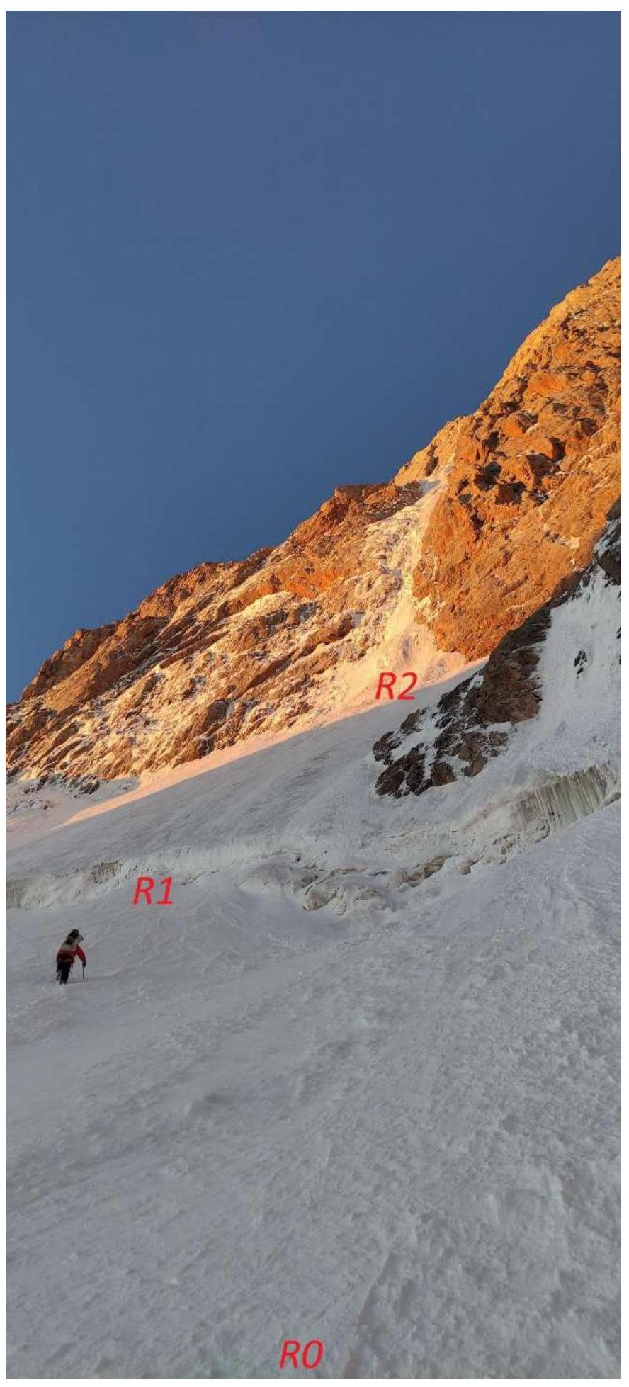
Photo 1. Section R0–R2.

Photo 2. Start of section R2–R3.
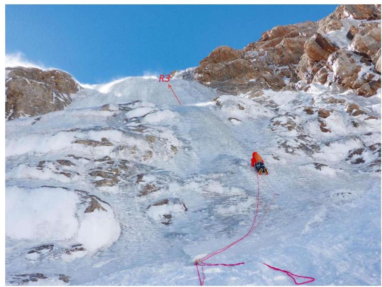
Photo 3. Section R2–R3, upper part.
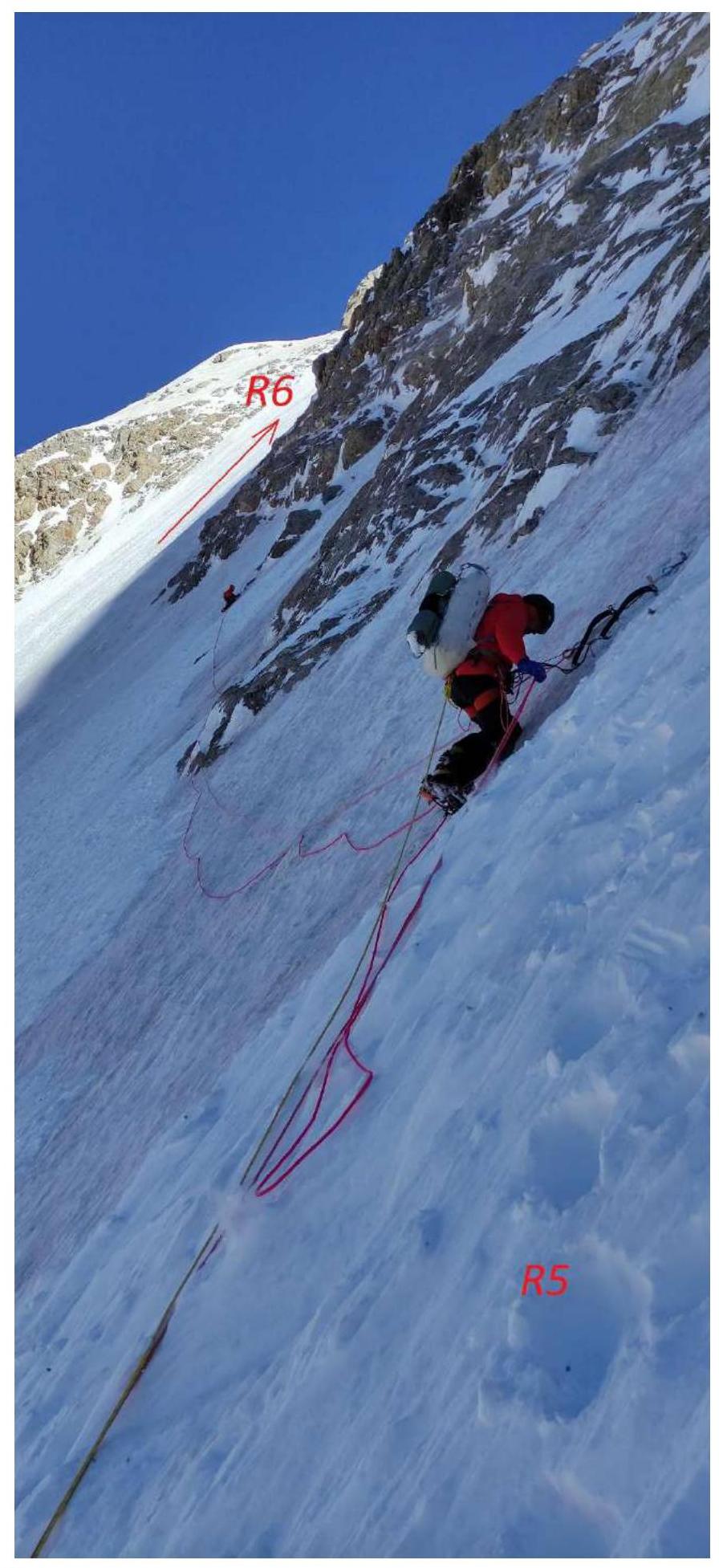
Photo 4. Section R5–R6.
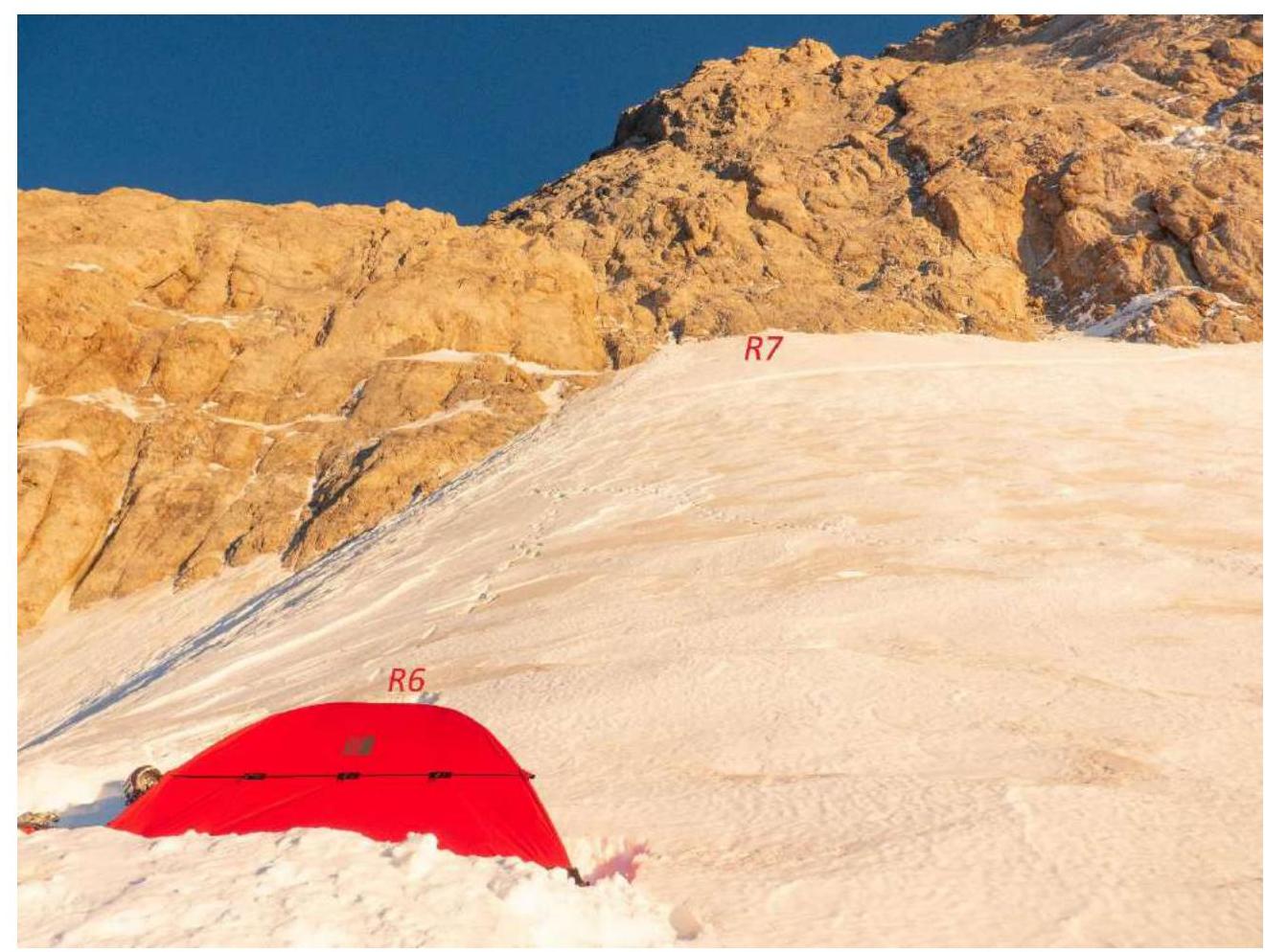
Photo 5. Section R6–R7. First bivouac.
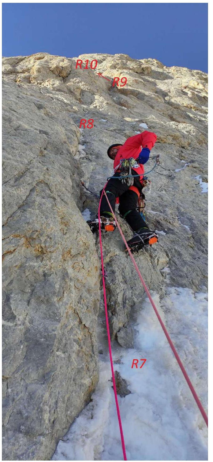
Photo 6. First rock bastion. Sections R7–R9.
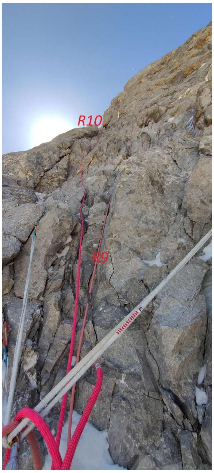
Photo 7. Section R9–R10.
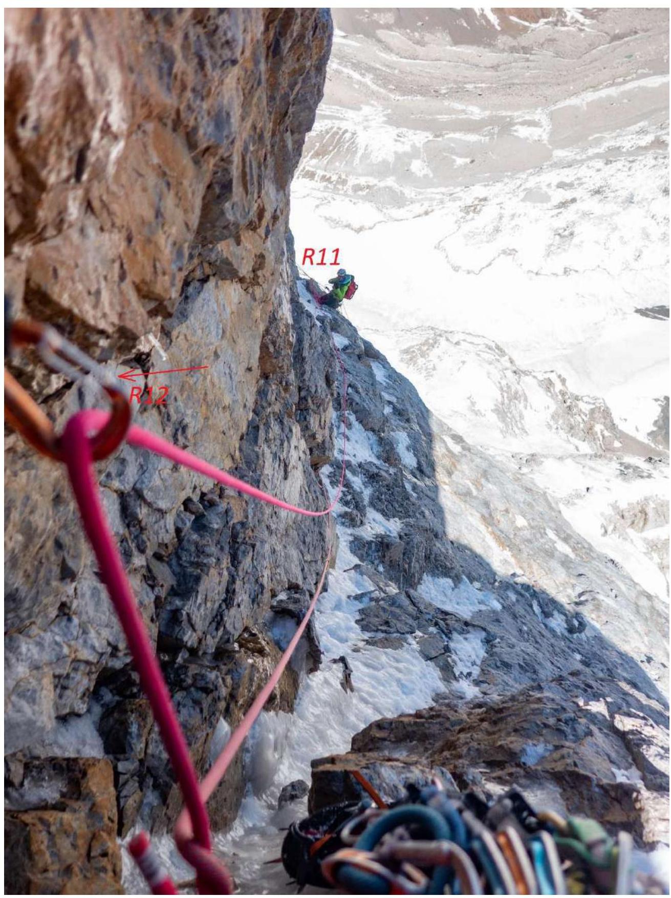
Photo 8. Section R11–R12.

Photo 9. Sections R13–R15.
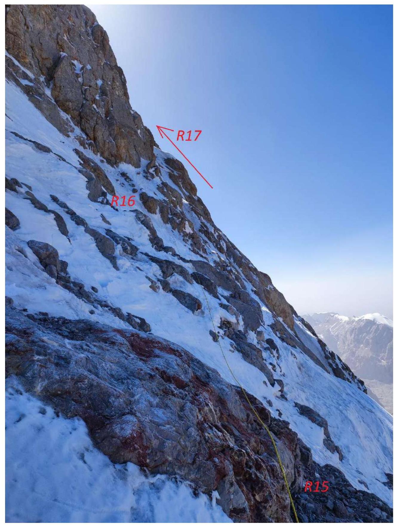
Photo 10. Sections R15–R17.
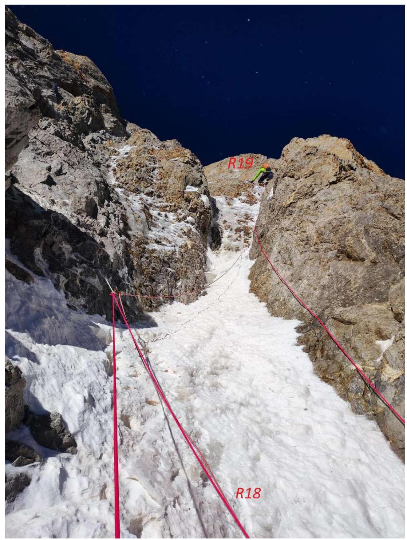
Photo 11. Section R18–R19.
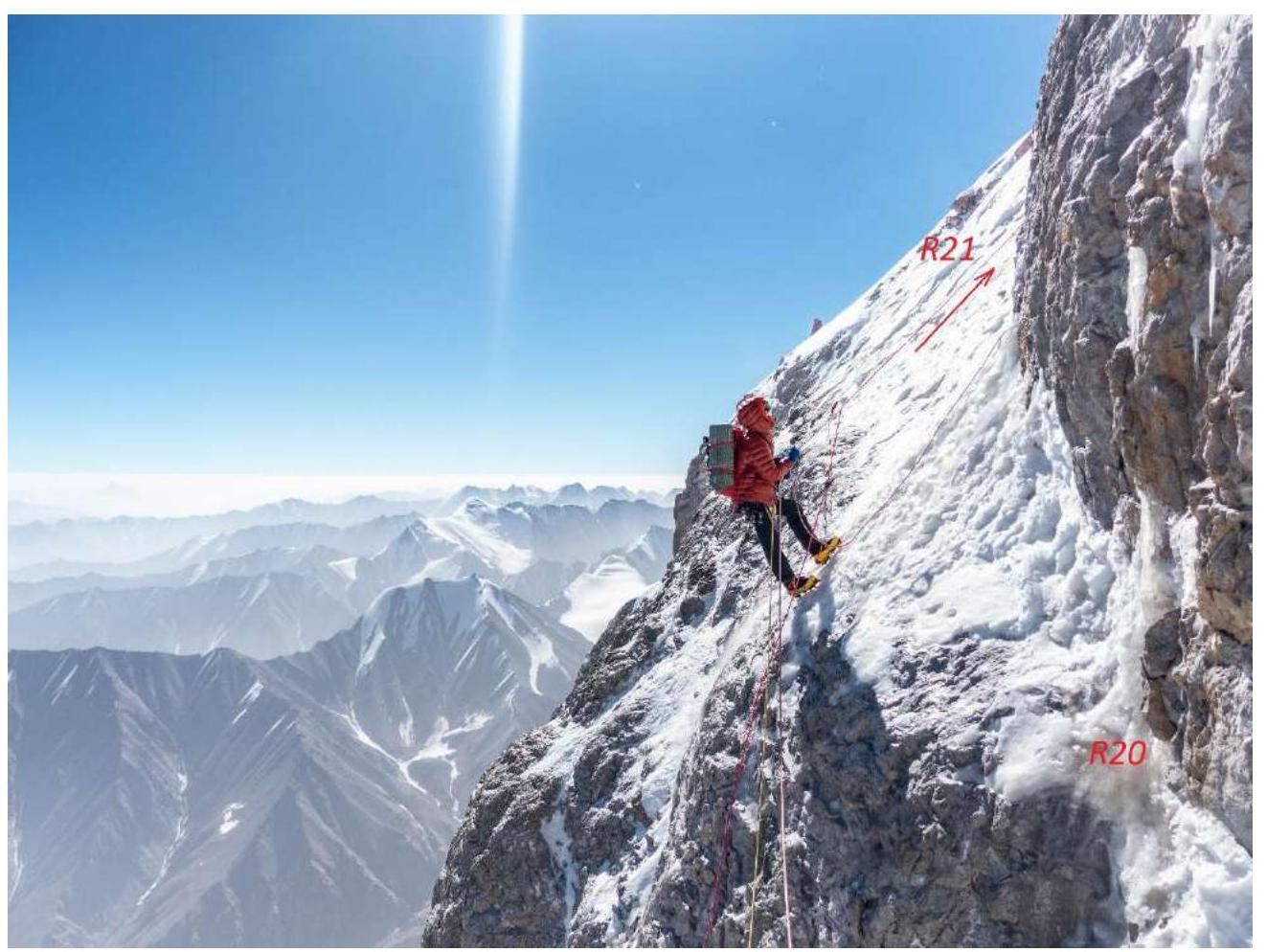
Photo 12. Section R20–R21.
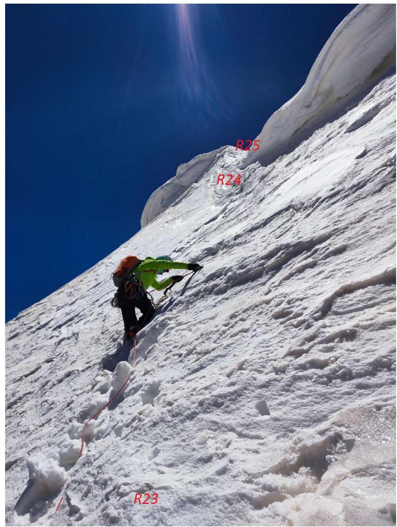
Photo 13. Sections R23–R25.
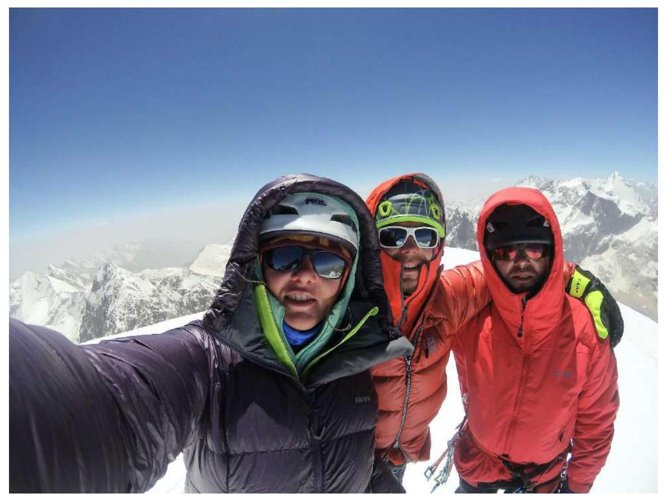
Photo 14. Team on the summit.
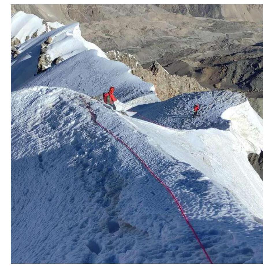
Photo 15. Descent along the ridge.
Conclusion
The route was climbed by the team without prior processing in 3 days to the summit, and almost a full 4th day was spent on descent. Throughout the route, movement was carried out with simultaneous protection, either "French rope" (all three participants climb while the leader lays out ropes) or the Krasnoyarsk simultaneous scheme (the leader climbs, the 2nd belays the leader and moves along fixed ropes, hanging a rope for the 3rd). Using the classic alternating scheme would have taken at least 2 more days. The route was climbed in Alpine style, without a platform; all bivouacs were on modified sites.
Our route on Peak Sergei Korolyova is more than twice as long and has a greater elevation gain than most routes on Peak Svobodnaya Koreya and 1.5 times some routes on the same peak in terms of the length of sections with V–VI category difficulty. The elevation gain and length of the new route can be compared to our 2017 route on Peak Sabah (2423 m and 2100 m, 1518 m and 1600 m, respectively, for Peak Korolyova and Peak Sabah), but on Peak Sabah, the length of rock sections is less.
The significant number of mixed sections on the route requires serious experience in climbing this type of terrain and great caution.
It is also worth noting that the overall labor intensity of the route significantly surpasses all 6A routes climbed by the team members up to this point.
We believe that, based on the combination of technical difficulty and altitude, the route corresponds to the 6B category.
The high speed of work on the route is due to the team's good acclimatization, preparation during the spring-summer period on the Krasnoyarsk Stolby, Tuva mountains, Caucasus, and a large volume of training on waterfalls in the Altai Mountains and Caucasus.
Comments
Sign in to leave a comment