MOSCOW ALPINISM AND ROCK CLIMBING FEDERATION
Report
On the ascent of the CSKA Demchenko team
To the summit of Pogranichnik 5270 m.
Central Tian Shan, Western Kokshaal-Too (40°59′59.36″ N 77°31′43.49″ E)
via the northern snowy couloir of the western ridge. First ascent presumably 4A category of difficulty.
Grigoryev D.R. — Zaryaev V.V.
Participants of the ascent
-
Leader — Grigoryev Dmitry Rurikovich, 1st sports category. Address: 115193, Moscow, 6th Kozhukhovskaya st., 18, bld. 1, apt. 19. rurikovichd@gmail.com, +7 903 145 88 61
-
Zaryaev Vladimir Valerievich ¹, 2nd sports category.
Address: 117465, Moscow, Profsoyuznaya st., 156, bld. 1, apt. 384. VVZaryaev@yandex.ru, +7 903 105 81 48. Coach: Kuznetsova E.V.
Route 4A to the summit of Pogranichnik via the Northern snowy couloir of the Western ridge
Ascent passport
-
Central Tian Shan, Western Kokshaal-Too region, Sarychat gorge, classifier section: 7.5.
-
Pogranichnik 5270 m (40°59′59.36″ N, 77°31′43.49″ E) via the northern snowy couloir of the western ridge.
-
Proposed — 4A category of difficulty, first ascent.
-
Route type: combined.
-
Route height difference: 870 m (by GPS).
Route length: 2900 m. Average slope: main part of the route — 30 degrees; total route — 20 degrees. There are two variants of passage.
-
"Hooks" left on the route: total — 0; including pitons — 0.
-
Team's climbing hours: 12 h (not counting descent), 1 day.
-
Leader: Grigoryev D.R., 1st sports category, instructor No. 1110. Participants: Zaryaev V.V., 2nd sports category.
-
Coach: Kuznetsova E.V.
-
Departure for the route: 07:30, August 25, 2015. Route started: 07:30 August 25, 2015. Summit reached: 19:30 August 25, 2015. Return to Base Camp: 02:00 August 26, 2015. Descent from the summit: not via the ascent route.
-
Organizations: Moscow Alpinism and Rock Climbing Federation, CSKA named after Demchenko, Zelenograd Alpinism and Rock Climbing Club.
-
Person responsible for the report — Zaryaev Vladimir Valerievich.
VVZaryaev@yandex.ru, +7 903 105 81 48
General photograph
of the summit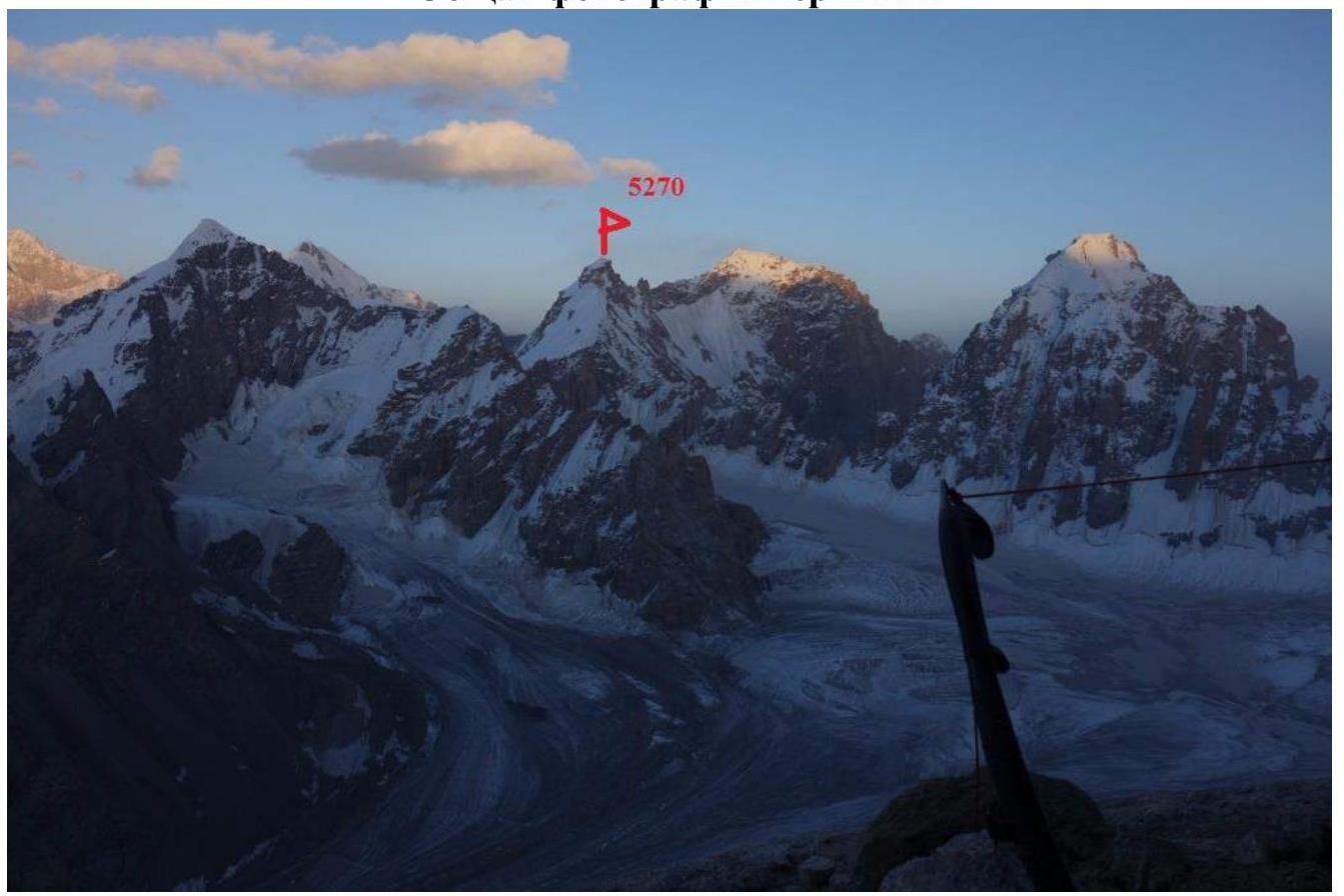
Fig. 1. View of Pogranichnik peak from Sedoy Strazh peak.

Fig. 2. View of Pogranichnik peak from Sarychat glacier.
Photographs of the route profile.
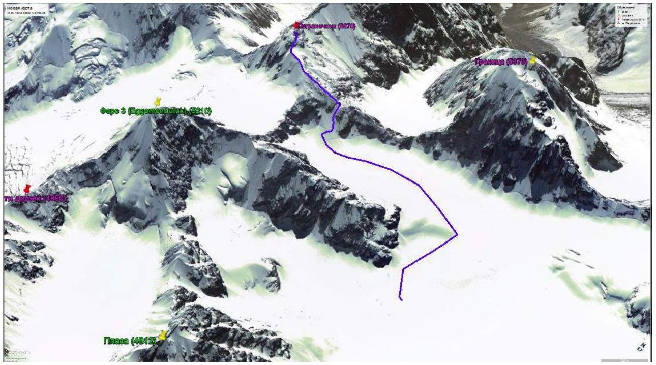
Fig. 3. Ascent route to Pogranichnik peak on Google image.

Fig. 4. Thread of the route to Pogranichnik peak. View from Sedoy Strazh peak.
Photopanorama of the area.
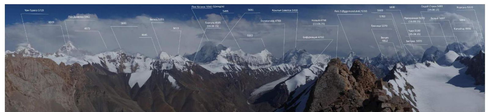
Fig. 5. Photopanorama taken from Novy peak to the south.
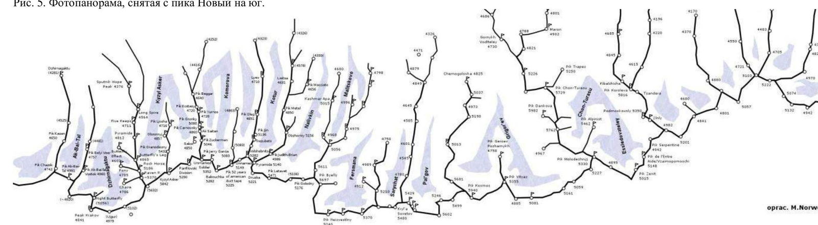
Fig. 6. Map of the area.
Central Tian Shan, Western Kokshaal-Too ridge, Pik Beliy (5486 m) area
Brief characteristic of the area
Western Kokshaal-Too is the southernmost ridge in Kyrgyzstan. This ridge is located in Central Tian Shan between Lake Issyk-Kul and the Takla-Makan desert, on the border of Kyrgyzstan with China. To the north, the Kokshaal-Too ridge borders the Uzengy-Kuush and Myudryum rivers, to the south — the Kokshaal River.
In this area, there are many peaks with heights around 6000 m. The most interesting among them are Kzyl-Asker peak (5842 m), Krylya Sovetov peak (5800 m), Shmidt peak (5954 m, not climbed), Dankova peak (5982 m), Chon-Turasy or Joldash peak (5729 m), Alpinist peak (5641 m), Sergey Korolev peak (5816 m). This area is characterized by a combination of typically alpine forms (many vertical rock walls with a height difference of about 1.5–2 km) with vast glaciation, уступающим only the glaciation in the area of Pik Pobedy. The entire area, including the lowlands, is a permafrost zone. Often there are swampy areas up to heights of 4000 m.
The snow line is at an altitude of about 4000–4500 m above sea level. River valleys have a high absolute height of about 3000–3500 m above sea level. The climate in the valley is harsh. The average monthly temperature in summer is about 5–8 °C, the weather is unstable.
Delivery
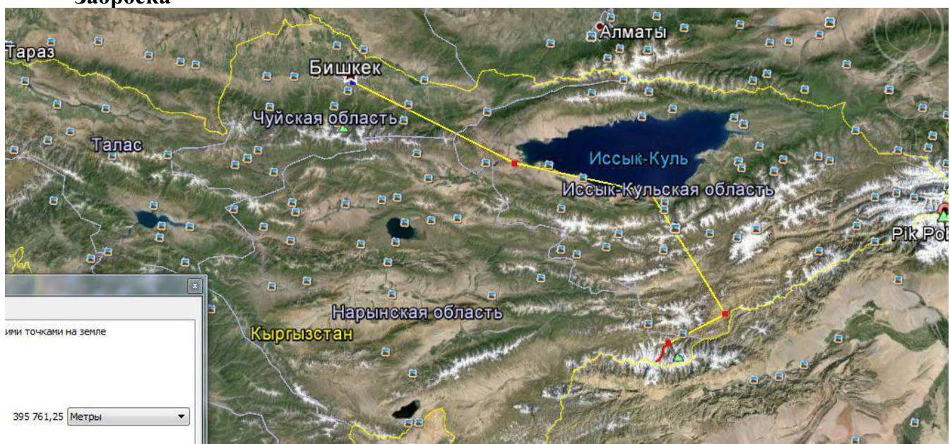
Fig. 7. Map of the route from Bishkek to the base camp in the Sarychat gorge.
Delivery from Bishkek by car. Along the southern shore of Issyk-Kul on the A363 highway to the village of Barsko-on. Further along the A 364 road. After 20 km, the asphalt ends, a dirt road begins, laid to the gold mining mine through the pass to the village of Kara-Sey. The A 364 road to the gold-bearing mines goes north. The first border post, crossing the wide Noryn River, further there is almost no road. Then through passes and rivers to the outpost. After the outpost along the Uzenngygu river to the south to the Bulat-M hunting lodge. From the hunting lodge, a very dangerous road along the river along the slope, sometimes you need to clear the debris. To the hunting lodge 20 hours drive. From the hunting lodge on foot along the left bank of the Uzenngygu river (follow the remains of the bridge from the hunting lodge) to reach the Autali River (crossing in case of a spill or crossing over stones upstream or downstream — depending on the weather). Further along the Sarychat River to the last grassy places on the slope, not reaching 1 hour to the melted tongue of the glacier. The base camp is set high above the river, in a flat hollow, protected from the wind. Before the mulda, there is a 100 m stream flowing in the grass, in the hollow itself, water is found in the crevices between large stones, often dries up and stagnates.

Fig. 8. Map of the path from the hunting lodge to the base camp in the Sarychat gorge.
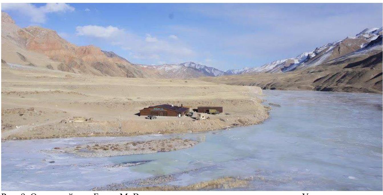
Fig. 9. Bulat-M hunting lodge. View from the southeast downstream along the Uzenngygu river.
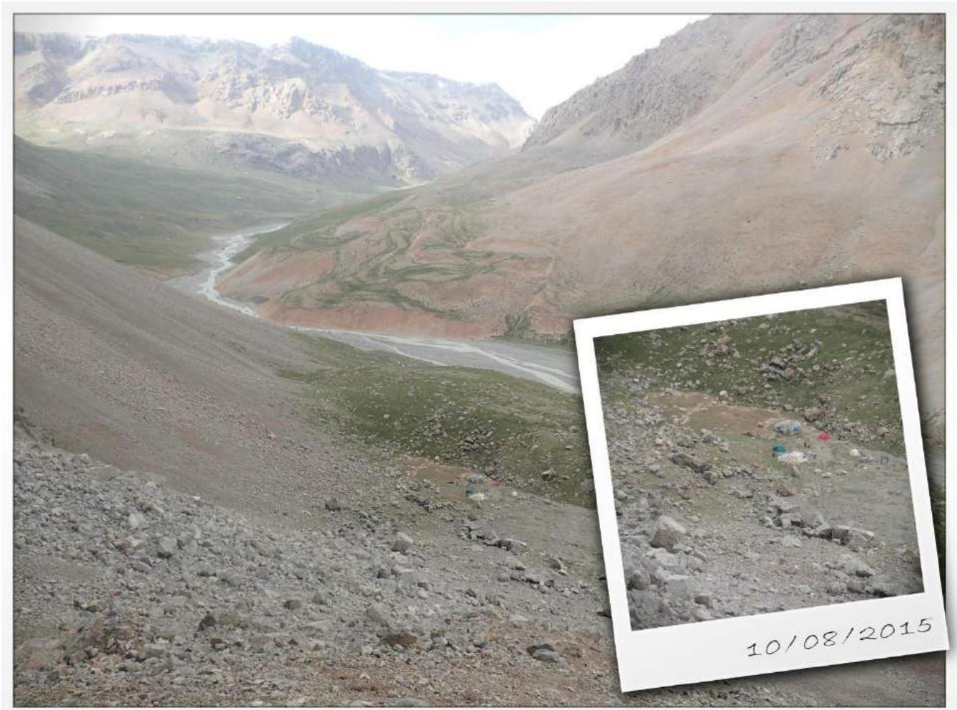
Fig. 10. Base camp in the Sarychat gorge.
Weather
The optimal time for expeditions here is considered to be the second half of July — until the first half of September. The weather is unstable, but with prolonged clear periods.
Bad weather is short-lived, almost always accompanied by strong stormy winds. Due to this, there are certain requirements for the base tent — it must be sufficiently wind-resistant.
In August, the weather cannot dramatically affect the ascents, given the nature
of the routes. Even in good weather, it gets quite cold in the mountains.
Considering all this, it is necessary to have appropriate clothing and the corresponding
attitude.
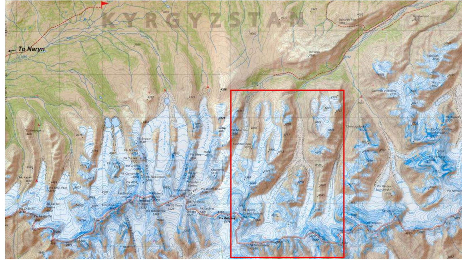
Fig. 11. Map of the area with the designation of the ascent location.
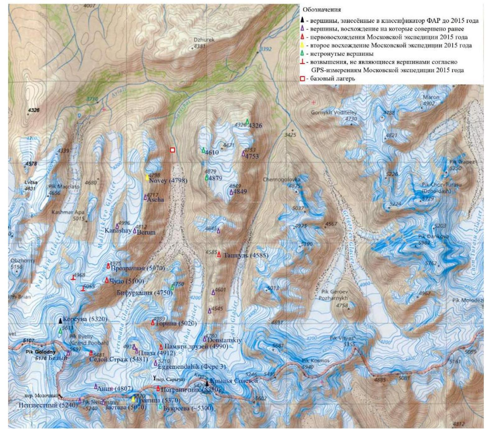
Fig. 12. Map with the designation of the peaks climbed during the Moscow team expedition in 2015.
Approach to the bivouacs
Bivouacs on the glacier at the base of the Western ridge of Fers 3 peak (Eggemenduluk). There is water (stream). See Fig. 4.
From the base camp, ascend along the orographic left bank of the river — first close to the river, and then between the moraines of the glacier (confluence of the Fersman and Sarychat glaciers), the "stone river" (accumulation of large boulders) leads to the right edge of the glacier. Maneuvering in the complex relief of the glacier, descend into the lowland of the Fersman Glacier. Moving diagonally to the right among the accumulation of stones, ascend to the moraine. Along the moraine walk approximately to the cirque of Sedoy Strazh, Beliy, Korsuna, and Chudo peaks. Descend from the moraine to the left and then straight ahead (forward, slightly to the left, you can press against the stream on the left and move along it) to the bivouacs (there may be small crevices in this section).
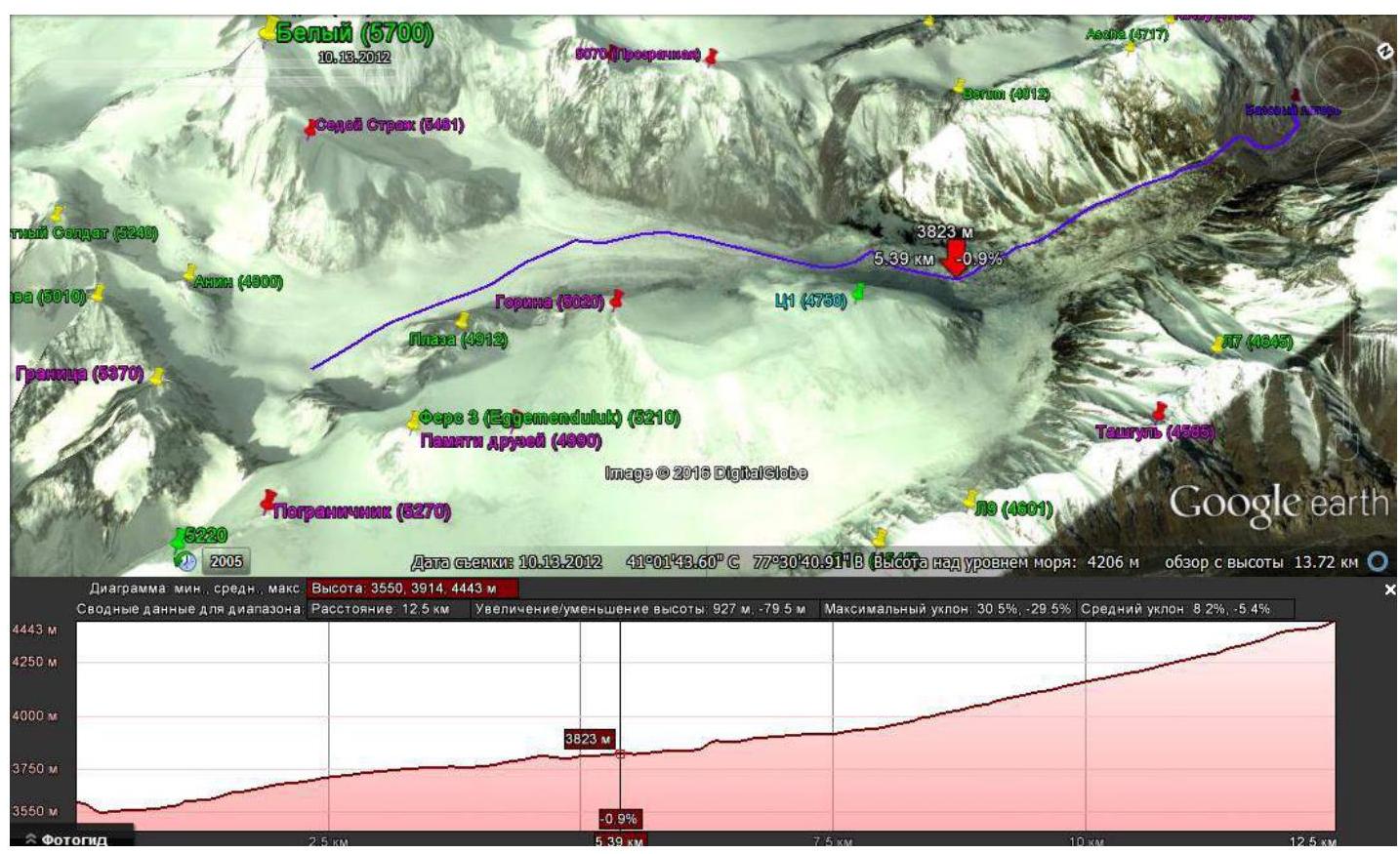
Fig. 13. Approach to the peaks of the main Kokshaal-Too ridge on a Google image with a relief profile.
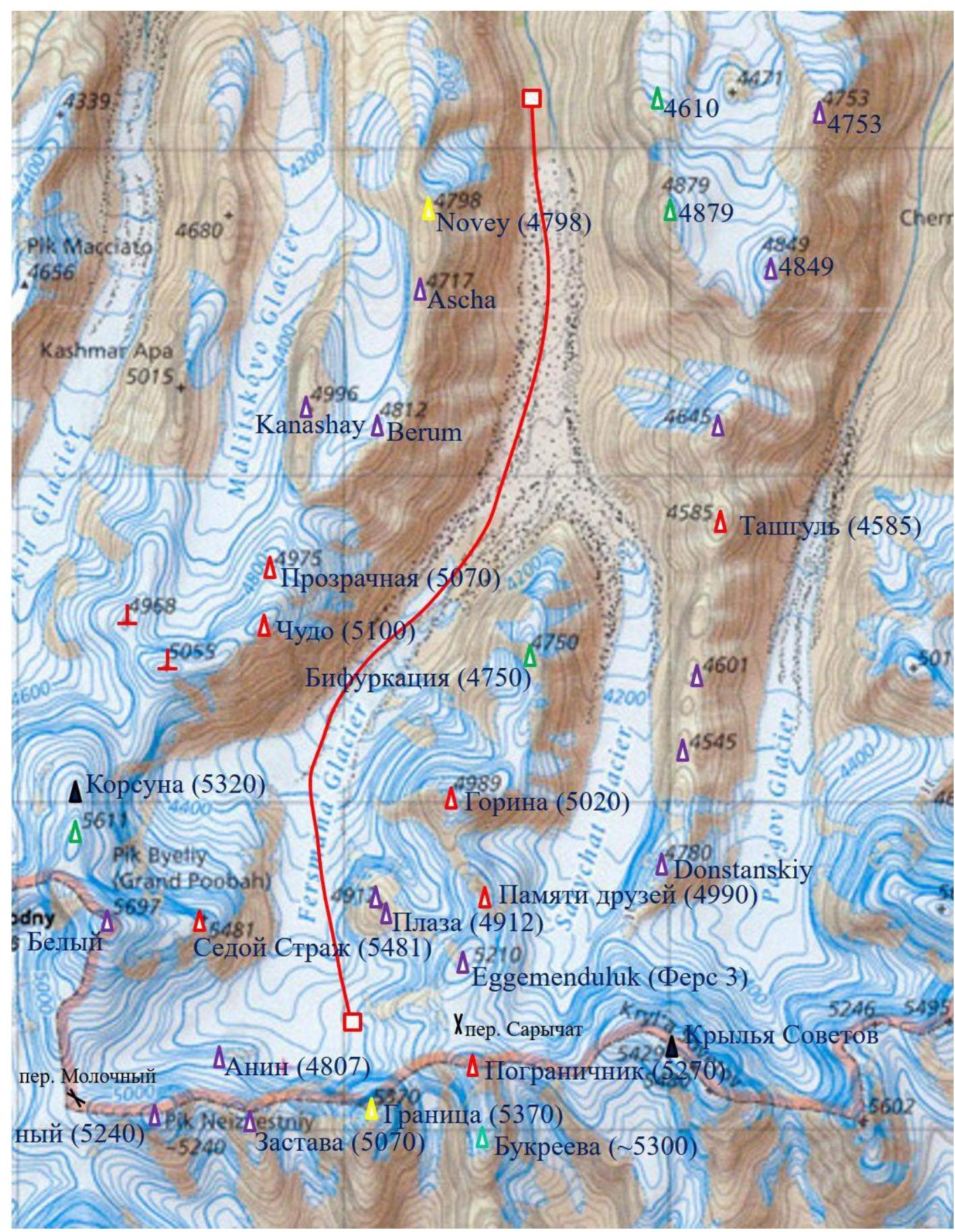
Fig. 14. Approach to the peaks of the main Kokshaal-Too ridge on the map (red line).
Technical photograph of the summit.
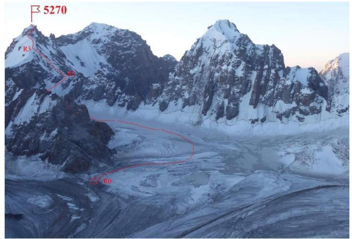
Fig. 15. View of the route from Sedoy Strazh peak. Points R1, as well as R4–R7 are not marked.
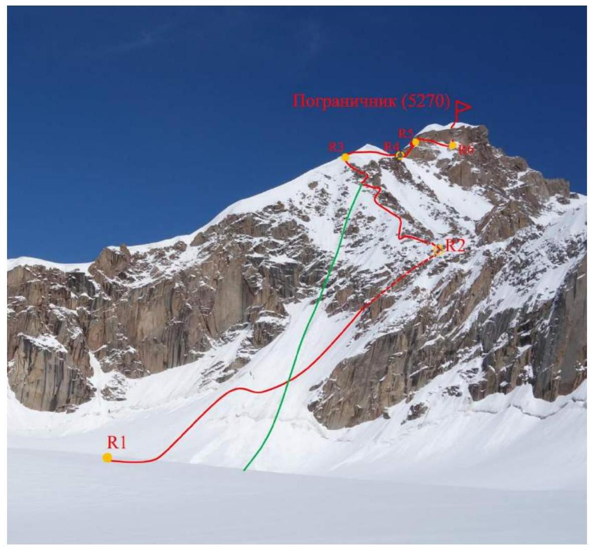
Fig. 16. Route from R0 to the summit. View from Fersmana glacier. Green line — descent.
Description of the route's difficulty sections
| Section No. | Length | Slope | Relief characteristics | Category of difficulty |
|---|---|---|---|---|
| R0–R1 | 1700 m | 10° | Closed glacier | I |
| R1–R2 | 350 m | 30 (20–50)° | Snow-ice slope | III+ |
| R2–R3 | 350 m | 30° | Snow-ice ridge (bypassing rocks) | III |
| R3–R4 | 250 m | 10–20° | Snow ridge | III |
| R4–R5 | 50 m | 30–50° | Combined slope | IV |
| R5–R6 | 100 m | 0–40° | Combined traverse | IV |
| R6–R7 | 50 m | 70–80° | Ice wall, rocks | V |
| R7–summit | 60 m | 15–30° | Snow slope, ridge | III |
| R5–R7′ | 40 m | 90–100° | Rock wall | VI, A1 |
| R7′–summit | 130 m | 15° | Snow ridge | III |
Brief description of the route passage by sections.
Departure from the bivouacs under Granitsa peak (point R0). There are two possible variants of the route passage: R0–R5–R7–summit and R0–R5–R7′–summit (see Fig. 19, 20).
R0–R1. Cross the stream and move towards the border, bypassing the glacier slope on the right. Then move along the ridge on the right (orographic left) side of the glacier. The glacier is closed — movement in rope teams, however, the main crevices are on the slope (which was bypassed). Reach the ice couloir on the right (not reaching the Sarychat pass, opposite Fers 3 peak), leading to the Main ridge to the right of its intersection with the spur. I 10° 1700 m. This is where the main part of the route begins.
R1–R2. Ascend the ice couloir. Start movement from the left part (movement in a rope team). At first, the snow is deep (up to the waist). Before the bergschrund, turn to the right diagonally. Here the open ice begins, the slope's steepness increases smoothly: movement in a rope team with simultaneous insurance using ice axes (if necessary, alternate insurance). Then move up along the right side of the couloir. At the end, a slight flattening, the amount of snow increases again (it is necessary to dig snow to ensure insurance). Reach the snow-ice ridge. III+ 20–50° 350 m.
R2–R3. To the left, to the East, a destroyed rocky ridge goes — move along it. All (glaciated) rocks are bypassed on the left along the snow-ice slope. Sometimes the line of rocks is interrupted and it is possible to go along the ridge itself, however, most of the R2–R3 section represents a traverse of the snow-ice slope. Moving in this way, approach the sharp snow ridge leading to the Southeast (slightly to the right), towards the summit. III 30° 350 m.
R3–R4. The most labor-intensive section (trudging through deep snow, Fig. 18). Move directly along the snow ridge, where the snow depth is slightly less. Movement in rope teams. The slopes of the ridge are steep and there is a possibility of falling off, despite the large amount of snow, however, making insurance points is problematic. Therefore, do not lose vigilance. Along the snow ridge, approach under the rocky bastion (closer to the end — bypass the snow cornice on the right) III 10–20° 250 m.
R4–R5. Under the rocky bastion, you can dig to the ice and make a station on ice axes. Upward there is a small couloir, sprinkled with snow (see Fig. 20, 21). Not complicated mixed climbing. Intermediate points on small-sized cams and/or nuts. Movement with alternate insurance. Having passed the couloir, exit to the snow slope and ascend along its left part to the ledge. There — a station on ice axes. IV 30–50° 50 m. From here, there are two variants of the route passage.
1st variant
Bypass the rocky bastion on the right and ascend to it along the ice wall (see Fig. 22). This variant was chosen by us when passing the route. It is technically simpler and requires less equipment, however, it is longer and (presumably) takes more time.
R5–R6. Along the snow, along the rocks, bypass the rocky bastion on the right. Movement with alternate insurance. The first rope passes along the boundary of rocks and snow, and therefore is a bit unusual. In some places, it is possible to hold onto the rocks. Intermediate points on cams, nuts. Station on ice axes. The second rope is snow-ice. From it, a narrow couloir with vertical ice is visible — the next (key) section of the route. Under the couloir is located a snow-ice ledge — exit to it. Station on ice axes. IV 0–40° 100 m.
R6–R7. The key rope passes along the ice formed on the wall, descending into the couloir with vertical steps. The reasons for the formation of this type of relief at such a height near the summit remain a mystery. Ice climbing is relatively simple and pleasant (enough two good ice axes). Intermediate points on ice axes. Along the ice wall, it is necessary to pass about 20 m to the ice ledge, on which it is possible to organize an intermediate station (the ice wall further goes to the left to the snow-ice cap of the summit). From the ledge, climb upward along the almost vertical rocks on the right. The rocks are frozen, however, there are many handholds and footholds. Insurance on cams, nuts, slings. Along the rocks, exit to the snow cap of the summit. V 70–80° 50 m.
R7–summit. Along the snow slope, ascend to the ridge of the snow-ice cap of the summit and reach the summit. Insurance is simultaneous and/or alternate through ice screws. III 15–30° 60 m.
2nd variant
Pass the bastion head-on along the overhanging rocks along the wide crack. This variant was not tested by us. It is technically more complex, requires rock equipment and the use of artificial aids (AIDs), however, with proper skill, can help save time.
R5–R7′. From the station on ice axes, a wide oblique crack is visible, leading to the snow-ice cap of the summit. Along it, it is possible to ascend using AIDs. Mainly large cams and nuts are required. Station at the top on ice axes. VI, A1 90–100° 40 m.
R7′–summit. Along the snow slope, ascend to the ridge of the snow-ice cap of the summit and reach the summit. Insurance is simultaneous and/or alternate through ice screws. III 15° 130 m.
Descent
From the summit along the snow ridge, reach the northern edge of the rocky bastion (point R7′). From R7′, rappel to R5 (Abalakov thread). Rappelling from R5 to R4 is possible both on the Abalakov thread and on an expendable thread (there are large stones and rock outcrops). From R4 along the ascent route (along the snow ridge) to R3. From R3 about 7 rappels to the base of the ice couloir. It is necessary to find a place for stations among the rocks, where there is enough ice to make an Abalakov thread (it is difficult and time-consuming to find large stones for rappel threads). Then along the glacier along the ascent route to the bivouacs under Granitsa.
General characteristics of the route
The main complexity of the route is its length and labor intensity. It is recommended to set up a camp directly under the ice couloir (at point R1 of the description) and depart as early as possible. The 2nd variant of passage (technically more complex), potentially allowing to save time, may be preferable.
Even better — to ascend to the summit with an overnight stay. An intermediate camp is recommended to be set up in the area of point R3 (not on R2, as it is not a logical path for descent), where it is possible to find a suitable site.
The main danger of the route is the possible deterioration of weather conditions towards the end of the day, which is quite characteristic of the area. Also, with very heavy snowfall, there is a possibility of avalanche danger, as on other peaks in the area of the Main ridge. There are also difficulties with insurance on the snow ridge R3–R4.
The relief of the route is diverse and interesting, especially the passage of the rocky bastion. Not counting the R3–R4 section, there are no significant problems with insurance on the route, although periodically it is necessary to dig snow to screw in an ice screw. Equipment: ice screws, cams, nuts of small and medium size. When choosing the 2nd variant, the amount of required rock equipment increases: ladders/AIDs and large cams are added. It is also necessary to prepare for a long descent along the ice slope.
Route length 2900 m, height difference 870 m.
Photo illustration of the report
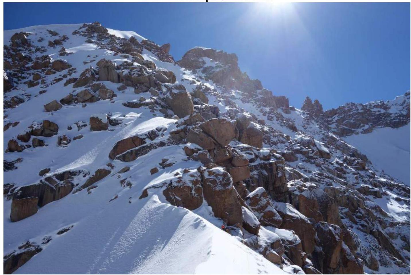
Fig. 17. Destroyed rocks of the R2–R3 section.

Fig. 18. Snow ridge (R3–R4 section).
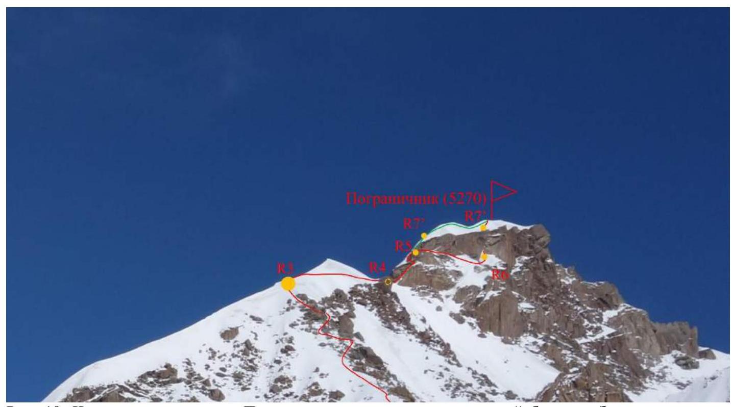
Fig. 19. Part of the route to Pogranichnik peak, including the rocky bastion. The green line marks the passage variant. The descent from the summit also follows this line.
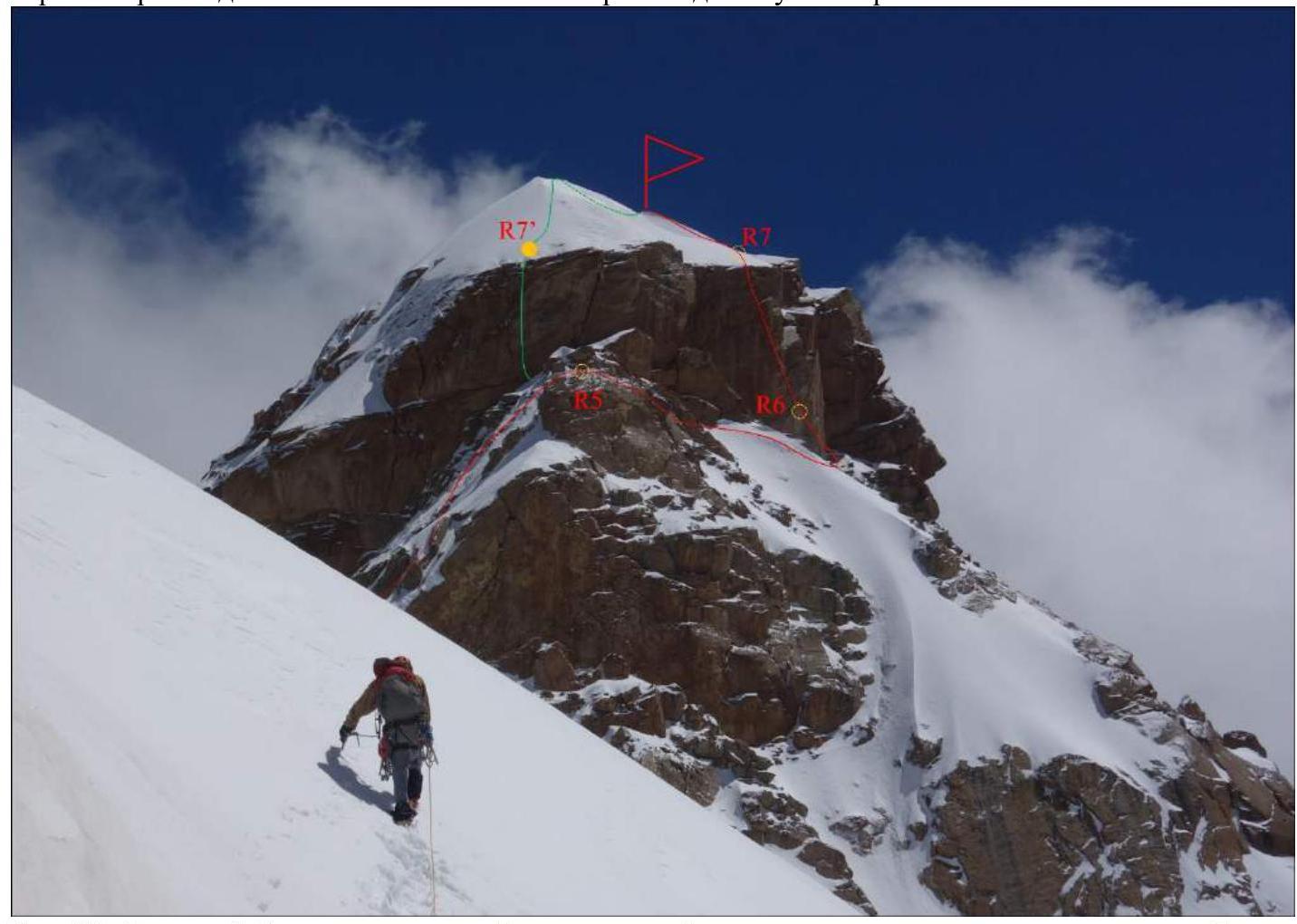
Fig. 20. Rocky bastion of Pogranichnik peak. The green line marks the passage variant. The descent from the summit also follows this line.
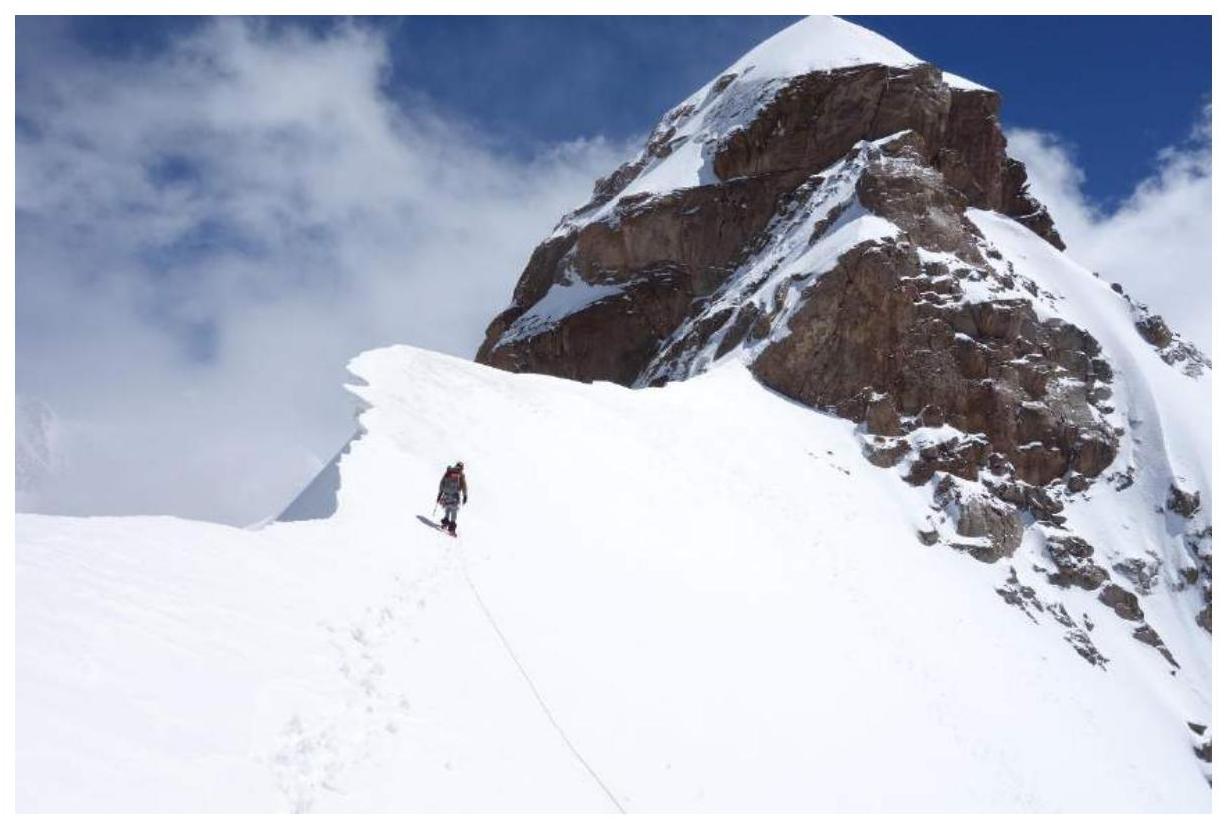
Fig. 21. Rocky Bastion of Pogranichnik peak.
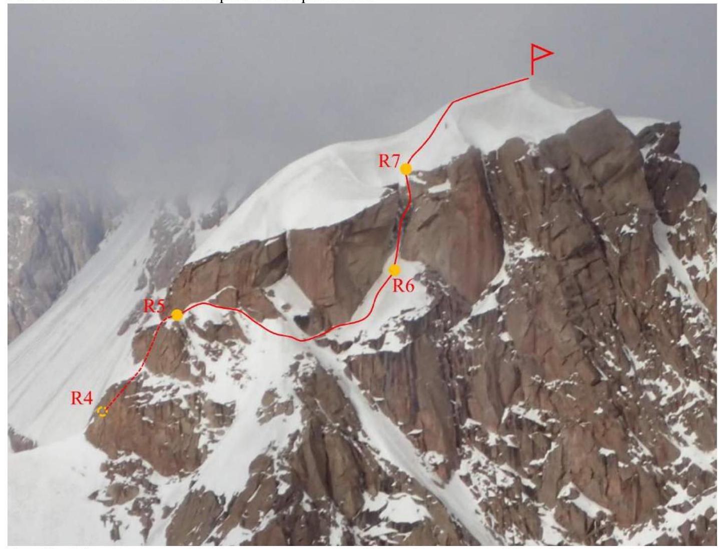
Fig. 22. Bypass of the rocky Bastion. Photo by the Nilov–Golovenchenko–Sharifullin team from Granitsa peak.
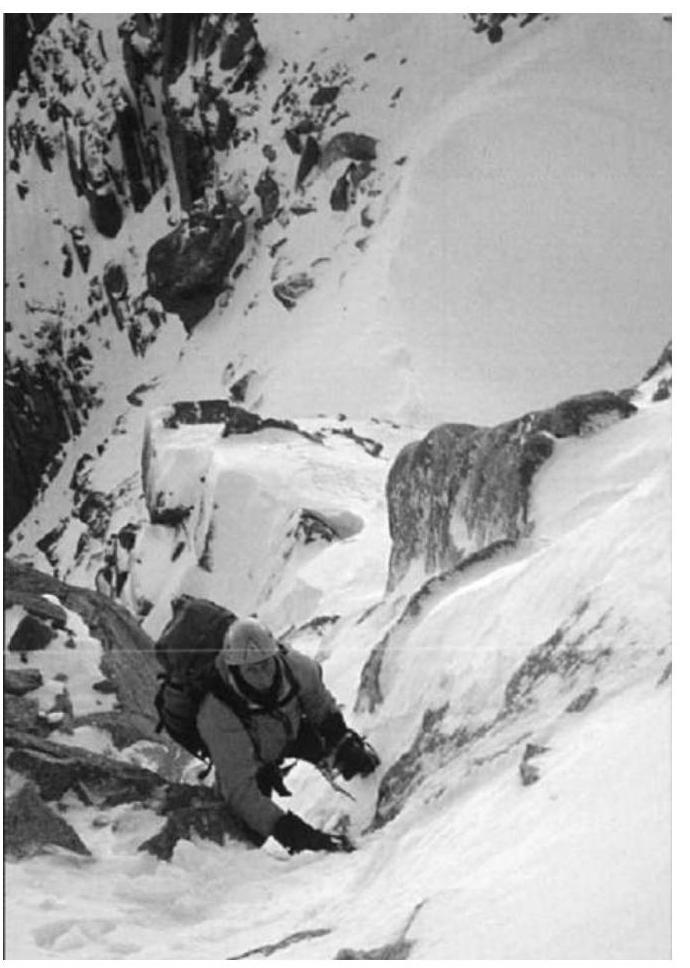
Fig. 23. Passage of the R4–R5 section. Photo by the Paul Knott expedition (New Zealand, attempt to ascend, 2005)
http://publications.americanalpineclub.org/articles/12200633100/Asia-Kyrgyzstan-Pamir-Alai-Western-Kokshaal-Too-Fersmana-Glacier-Pik-Neizvestniy-First-Ascent-and-Various-Attempts↗
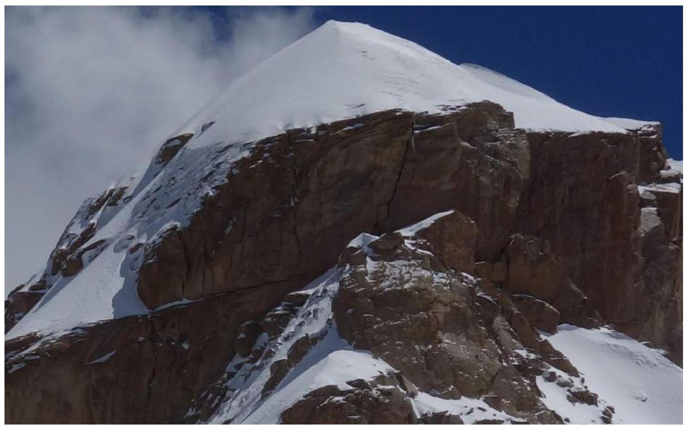
Fig. 24. Rocky bastion. R5–R7′ section of the alternative route variant.
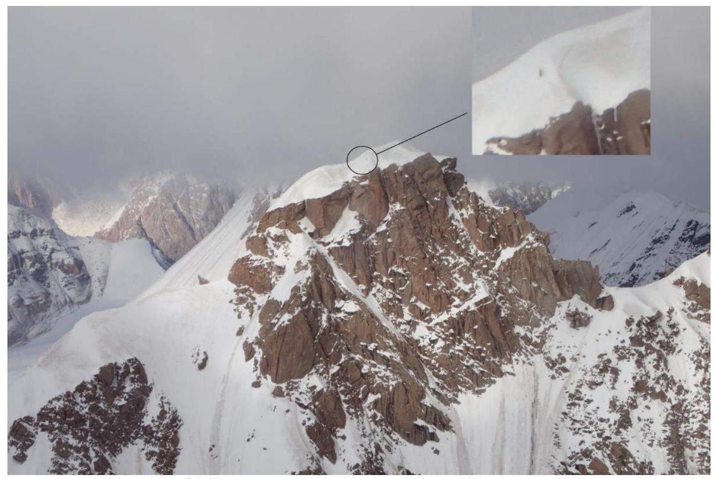
Fig. 25. On the snow-ice cap of Pogranichnik peak. Photo by the Nilov–Golovenchenko–Sharifullin team from Granitsa peak.
Footnotes
-
Actual full name: Nikitin Vladimir Valerievich (Zaryaev — pen name) ↩