
XXXIII USSR Alpine Climbing Championship 1982
Class: High-altitude technical
REPORT on the ascent of Peak POIBEDA (7439 m) via the northern wall (first ascent) by the team of the Armed Forces of the USSR
Team leader — S.V. Smirnov
Coach — E.T. Ilyinsky, Honored Master of Sports, Honored Coach of the USSR
1982
Addresses and phone numbers:
- Team leader — Smirnov Vadim Anatolyevich
- Team coach — Ilyinsky Ervand Tikhonovich, 480012, Alma-Ata, Seifullina St., 537, apt. 4, ph. 67-79-52
- Organization — 480051, Alma-Ata, 51, 12, SCA SAVO, Olenin I.L.
- Heights determined using topographic maps.
II place
Passport
I. High-altitude technical class 2. Central Tien Shan, Kokshaal-Tau ridge, South Inylchek valley 3. POIBEDA peak, via the northern wall 4. Proposed — 6B category of difficulty, first ascent 5. Height difference — 2939 m, route length — 3860 m
Length of sections with 5–6B category of difficulty — 2150 m; of which 6B category of difficulty — 550 m. Average steepness of main sections — 70° (5200–5700 m), (6400–6900 m)
- Number of pitons driven: rock pitons 218 pcs., screw pitons 3 pcs., ice pitons 51 pcs.
- Time taken — 69 hours, days — 10
- Overnight stays: R1–R3 — snow platform; R4–R5 — ice-hollowed; R6–R7 — artificially constructed; R8 — ice-hollowed; R9 — artificially constructed
- Team leader: Smirnov Vadim Anatolyevich — Honored Master of Sports
Team members:
- Moiseev Yuri Mikhailovich — Candidate for Master of Sports
- Suvita Vladimir Ivanovich — Candidate for Master of Sports
- Khalitov Zinnur Shagabutdinovich — Candidate for Master of Sports
- Shkarban Viktor Vladimirovich — Master of Sports
- Coach: Ilyinsky E.T., Honored Master of Sports, Honored Coach of the USSR
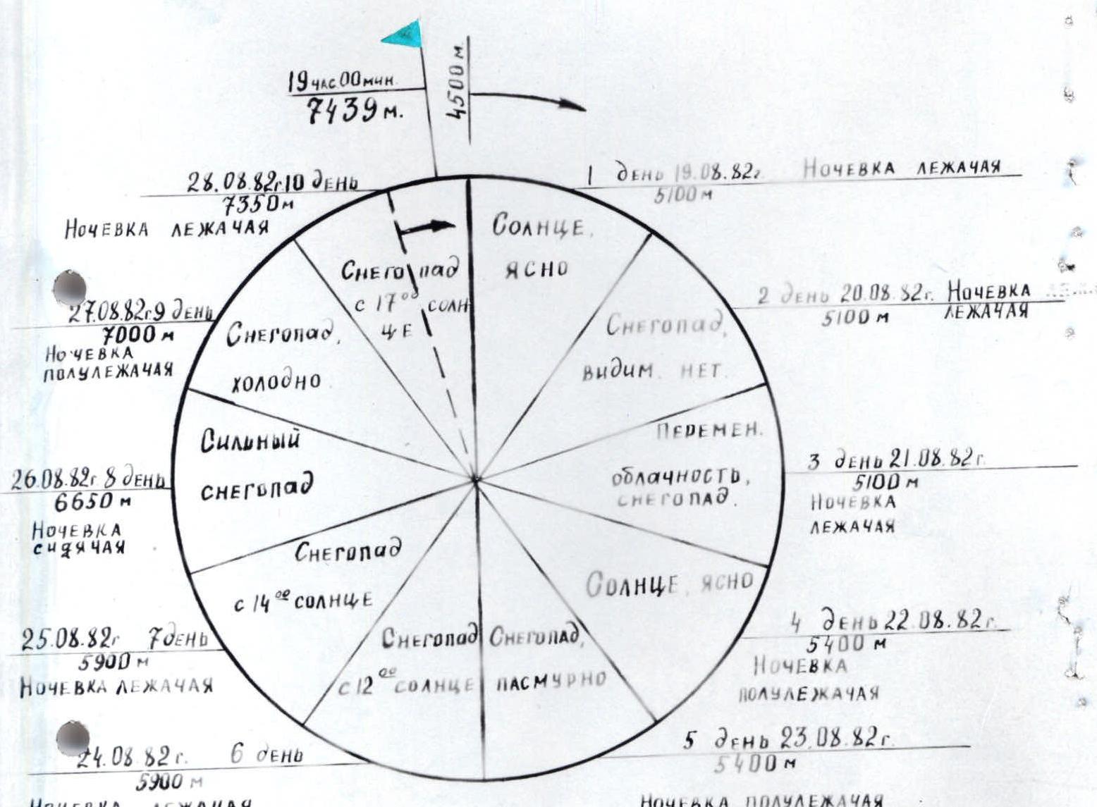
II. Departure — August 19, 1982 Summit — August 28, 1982 Return — August 30, 1982
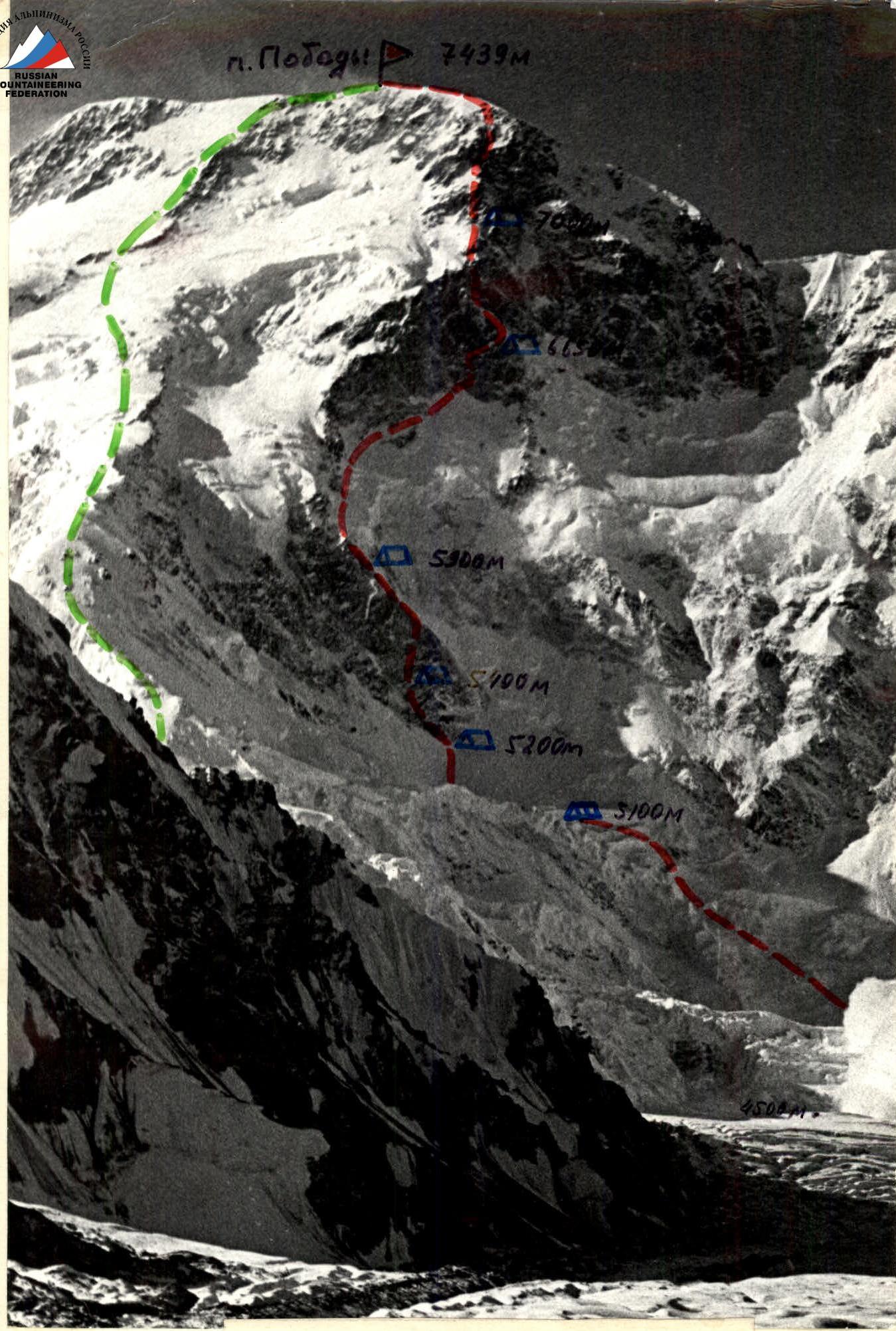
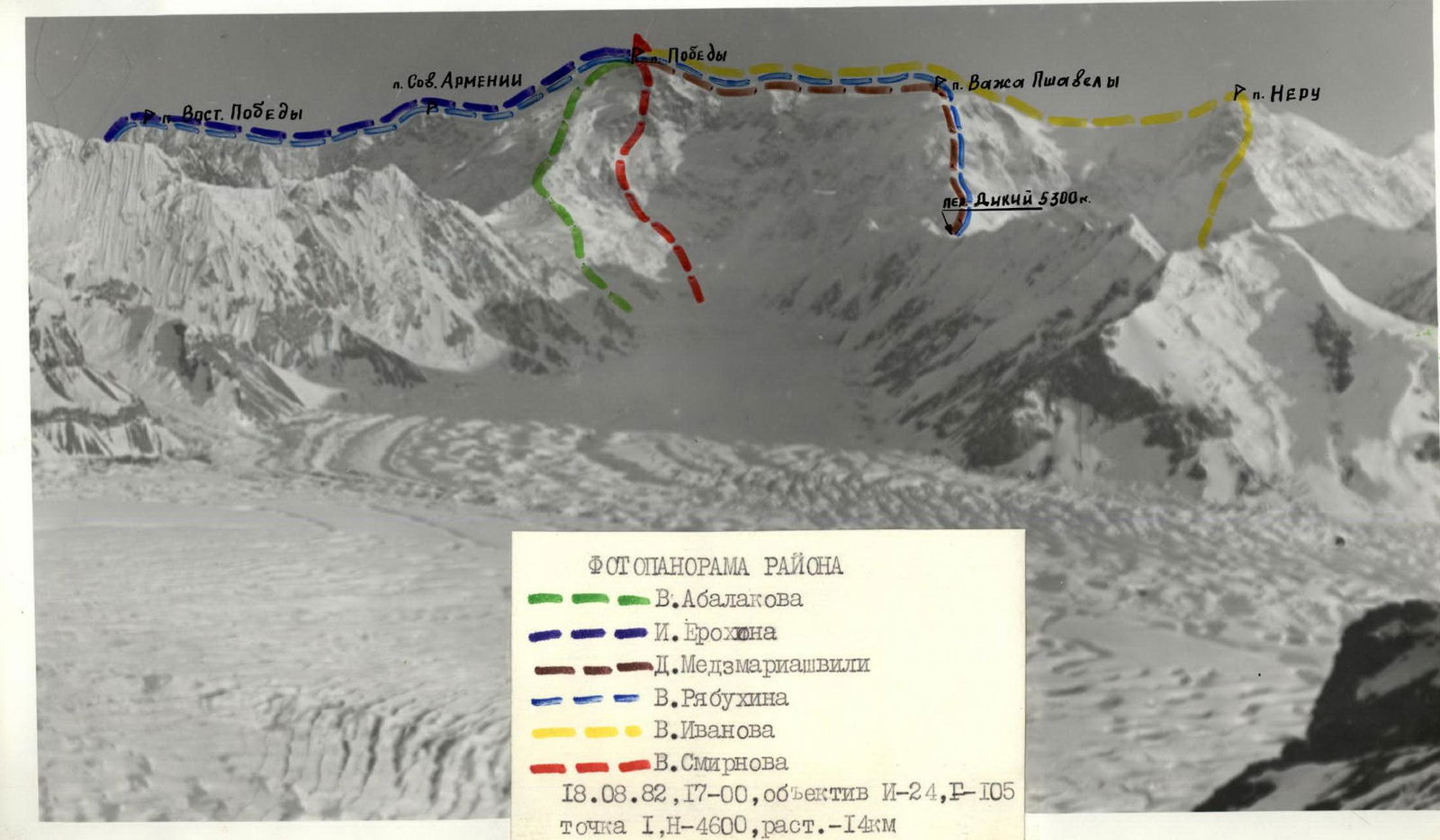
General photo of the summit Team route V. Abalakov's route. August 1981, 9:00, lens I-24, F–105, point I, H–4600 m, distance — 14 km. (Photo by E. Slepushkin)
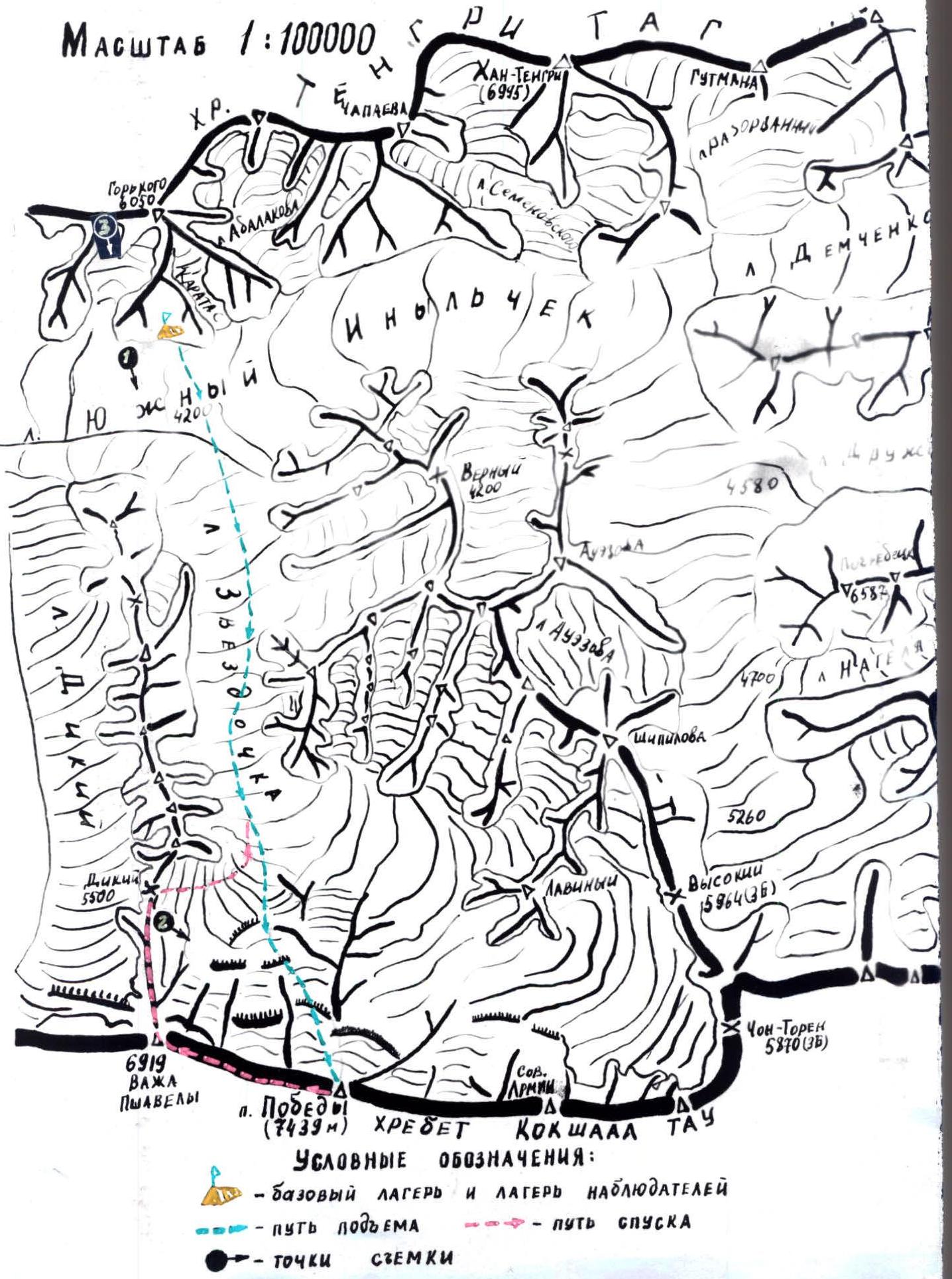
Scale map of the POIBEDA peak (7439 m) area. Kokshaal-Tau and Tengritag ridges.
0
Brief overview of the climbing area
Peak POIBEDA (7439 m) is the northernmost seven-thousander of the planet. The POIBEDA massif is located in the upper reaches of the Zvezdochka glacier (a left tributary of the South Inylchek glacier). The massif is situated in the Kokshaal-Tau ridge. The main summit is a combined ridge approximately 1.5 km long. To the west, the ridge descends in three fairly steep steps to a height of 6900 m and continues to a new small rise: Peak V. Pshavela (6918 m). To the east, the massif lowers to Eastern POIBEDA (7003 m), forming the eastern shoulder of POIBEDA peak with a small rise: Peak Soviet Armenia. The eastern shoulder steeply descends to the Chonterek pass. The length of the POIBEDA massif from its Eastern summit to Peak V. Pshavela is about 10 km.
History of summit conquest
The first ascent of POIBEDA peak (7439 m) was made by a team from Moscow "Spartak" led by V.M. Abalakov via the northern ridge in 1956.
In 1958, a team led by I. Erokhin made an ascent to the main summit of POIBEDA peak from the Chonterek pass.
In 1961, Georgian climbers led by D. Medzmariashvili climbed to the main summit via Peak V. Pshavela (6918 m).
In 1967, under the leadership of V. Ryabukhin, a complete traverse of the POIBEDA massif was made from the Diky pass to the Chonterek pass. Since then, no new routes have been laid on POIBEDA peak.
Preliminary familiarization and photography of the route on POIBEDA peak via the northern wall were done by team coach E. Ilyinsky and team captain V. Smirnov in 1974. At that time, the route was photographed and outlined, with some sections photographed from a helicopter.
Technical and physical preparation for the 1982 championship was conducted through joint training and climbing by all team members (three team members, being part of the USSR national team, participated in the Himalayan expedition starting from November 1981).
At the first stage of preparation, the focus was on further developing overall and special physical fitness, improving tactical and technical techniques for overcoming complex rock and ice terrain.
Experience from previous ascents on Peak Khan-Tengri from the north, Peak Rossia from the southeast, and Peak Kommunizma from the southeast was taken into account.
At the second stage of preparation, starting from February, the focus was on preparing for the specific ascent on POIBEDA peak. Training was conducted in the gym, in the Medeo and Tuyuk-Su areas. Normalization tests for general physical fitness and technical preparation were conducted, and equipment was prepared and tested.
The third stage of preparation for the USSR championship was conducted under Peak Lenin on a 20-day training camp focused on special technical preparation, where control training on rock and ice terrain was conducted, normalization tests were taken, and a training ascent on Peak Lenin was made. The team gained good acclimatization.
The team thoroughly studied and outlined the path on the northern wall. The regime and locations of avalanches and icefalls were clarified. A reconnaissance of the icefall was conducted.
The planned route represents a logical, technically complex path.
The tactical plan was developed considering avalanche danger, steepness, and terrain of rock and ice sections, as well as the harsh weather conditions of that season. The two rock triangles, especially the lower one, were considered the most technically challenging. Preliminary processing of these sections was planned. To ensure safety, the passage of avalanche-prone sections was planned for early morning.
The tactical plan included a contingency plan for worsening weather, with an additional supply of food, fuel, and personal gear for 4 days.
Ascent schedule
Tactical actions of the team
The team's tactical actions during the route were determined by the tactical plan, taking into account changes in the situation during the ascent.
Almost all sections of the route were overcome by free climbing. On sections R7–R8 and R9–R10, ITI (Intermediate Technical Installation) was used. Places threatening avalanche and icefall were passed:
- early in the morning;
- at the maximum possible speed with careful belaying;
- whenever possible under the cover of rock and ice walls.
On technically complex sections, the first climber worked without a backpack, on a double rope. Due to the strong glaciation of the rocks, the entire route was traversed with crampons.
The first rock triangle proved more challenging than expected from visual observation: many strongly smoothed sections (apparently, the result of years of glacier activity), cracks filled with ice. There were very few suitable places for setting up belays. There were practically no places for lying down for overnight stays, except for the upper part of the first triangle. The presence of complex rock terrain led to:
- the need to set up an overnight stay in the middle part of the first triangle;
- the need to stop for the night on the second triangle below the planned level;
- and the next overnight stay on the upper part of the rock-ice ridge under the rock belt.
The following rope teams were formed for work on the route:
- Smirnov — Suvita — Chepchev
- Shkarban — Moiseev — Khalitov
- Lunyakov — Panteleev — Vinokurov
After the departure of the four: Smirnov — Suvita, Shkarban — Moiseev — Khalitov. During the ascent, all participants worked as the first climber, and the rope teams changed each other evenly. Thanks to good cohesion, technical and physical preparation, the composition of the rope teams changed depending on the situation on the route.
According to the tactical plan, the most complex and dangerous places on the route were passed with preliminary processing: sections R2–R10, R13–R14.
Considering the steepness and nature of the rocks, as well as the large amount of rime ice on most sections R2–R16, R21–R36, ropes were used for safety.
The movement regime on the route was compiled considering the steepness and complexity of the terrain, weather conditions. The number of working hours was on average 6–8. Each participant had an individual snack for the day. Overnight stays were organized in safe, sheltered places.
Overnight stays:
- R1–R3 — on a snow cushion under the cover of an ice wall;
- R4 — for the first tent: under the rock triangle, ice-hollowed (sitting); for the second tent: 200 m higher, ice-hollowed in rime ice;
- R5 — on the upper platform (after descending one tent);
- R6–R7 — in the upper part of the first triangle on an artificially constructed platform (lying down);
- R8 — ice-hollowed under a cornice (sitting);
- R9 — on the ridge under a rock wall (semi-reclining).
There were no falls or injuries. After the fourth overnight stay, G. Lunyakov felt slight discomfort from an old injury sustained in the previous season during rescue work at the "Dugoba" alpine camp. Considering the harsh climate of the area and the worsening weather, it was decided to send Lunyakov down, accompanied by Chepchev, Panteleev, and Vinokurov.
Upon arrival in Alma-Ata, V. Shkarban showed signs of frostbite on the tip of the big toe of his right foot, but it's possible it was just inflammation. Titanium alloy ice and rock pitons, slings, and lightweight calandre tents were widely used on the route.
Communication with the observation group under the slopes of Peak Gorky was carried out using a VHF radio station.
Daily communication sessions: 8:30, 16:30, 20:00; emergency — 12:30.
The observation group continuously monitored the team visually using a 60x telescope.
Constant communication was maintained with the KSP of the Trans-Ili Alatau (Alma-Ata) and the KSP of the Central Tien Shan (Przhevalsk) via a long-range radio station.
Before leaving Alma-Ata, it was discovered that the declared team captain, V. Khritshaty, would not be able to participate in the championship due to his participation in the Himalayan expedition.
A letter was sent to the Sports Committee on June 15, 1982, requesting to replace the team captain.
A response was received on June 20, 1982, with permission for the replacement (telephone message attached).
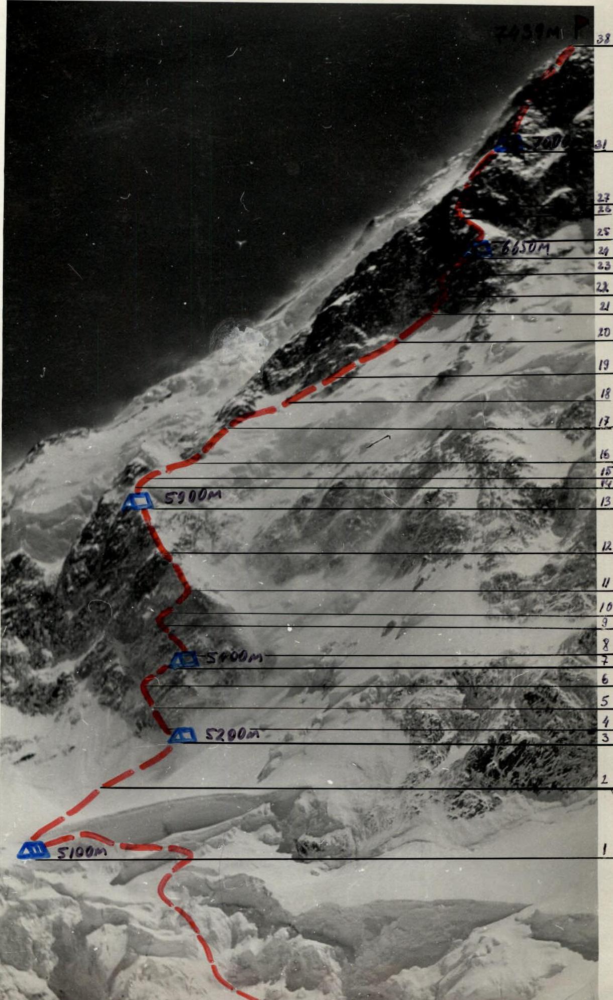
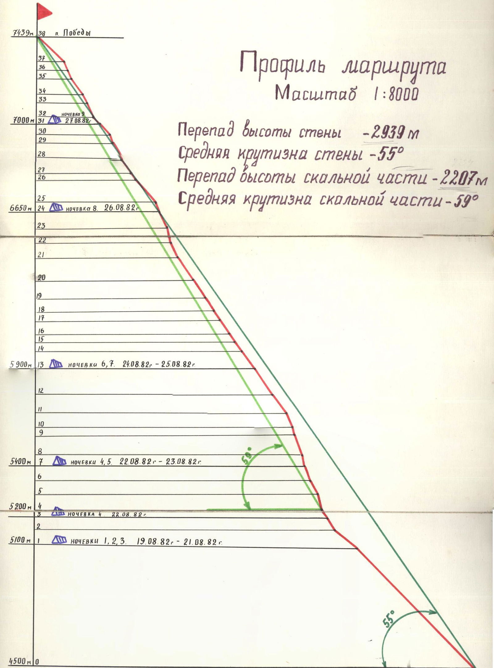
Route profile
| Section | Height (m) | Steepness (°) | Note |
|---|---|---|---|
| R0 | 4500 | ||
| R1 | 5100 | 45 | Overnight stays R1–R3, August 19–21, 1982 |
| R2 | 5200 | 35 | |
| R3 | 5200 | 60 | |
| R4 | 5400 | 50 | Overnight stay R4, August 22, 1982 |
| R5 | 5400 | 60 | Overnight stays R4–R5, August 22–23, 1982 |
| R6 | 5900 | 70 | |
| R7 | 5900 | 70 | Overnight stays R6–R7, August 24–25, 1982 |
| R8 | 6650 | 60 | Overnight stay R8, August 26, 1982 |
| R9 | 7000 | 65 | Overnight stay R9, August 27, 1982 |
| R10 | 50 | ||
| R11 | 55 | ||
| R12 | 50 | ||
| R13 | 55 | ||
| R14 | 50 | ||
| R15 | 60 | ||
| R16 | 65 | ||
| R17 | 70 | ||
| R18 | 55 | ||
| R19 | 55 | ||
| R20 | 55 | ||
| R21 | 55 | ||
| R22 | 65 | ||
| R23 | 45 | ||
| R24 | 65 | ||
| R25 | 60 | ||
| R26 | 50 | ||
| R27 | 50 | ||
| R28 | 65 | ||
| R29 | 55 | ||
| R30 | 75 | ||
| R31 | 75 | ||
| R32 | 55 | ||
| R33 | 60 | ||
| R34 | 65 | ||
| R35 | 70 | ||
| R36 | 55 | ||
| R37 | 65 | ||
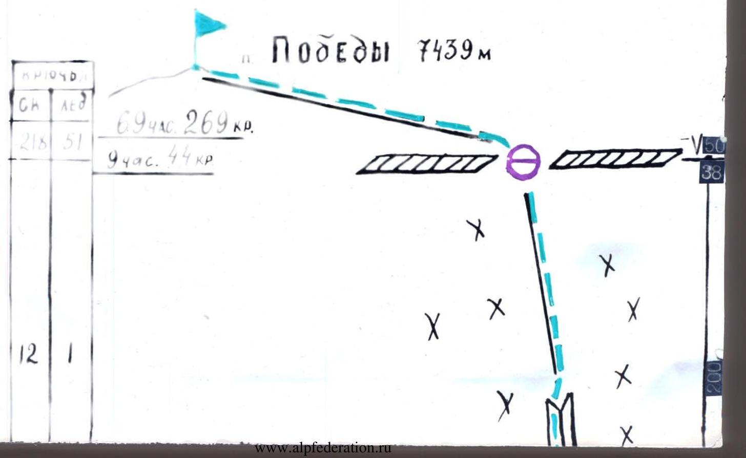
| R38 | 7439 | August 28, 1982 (Summit) |
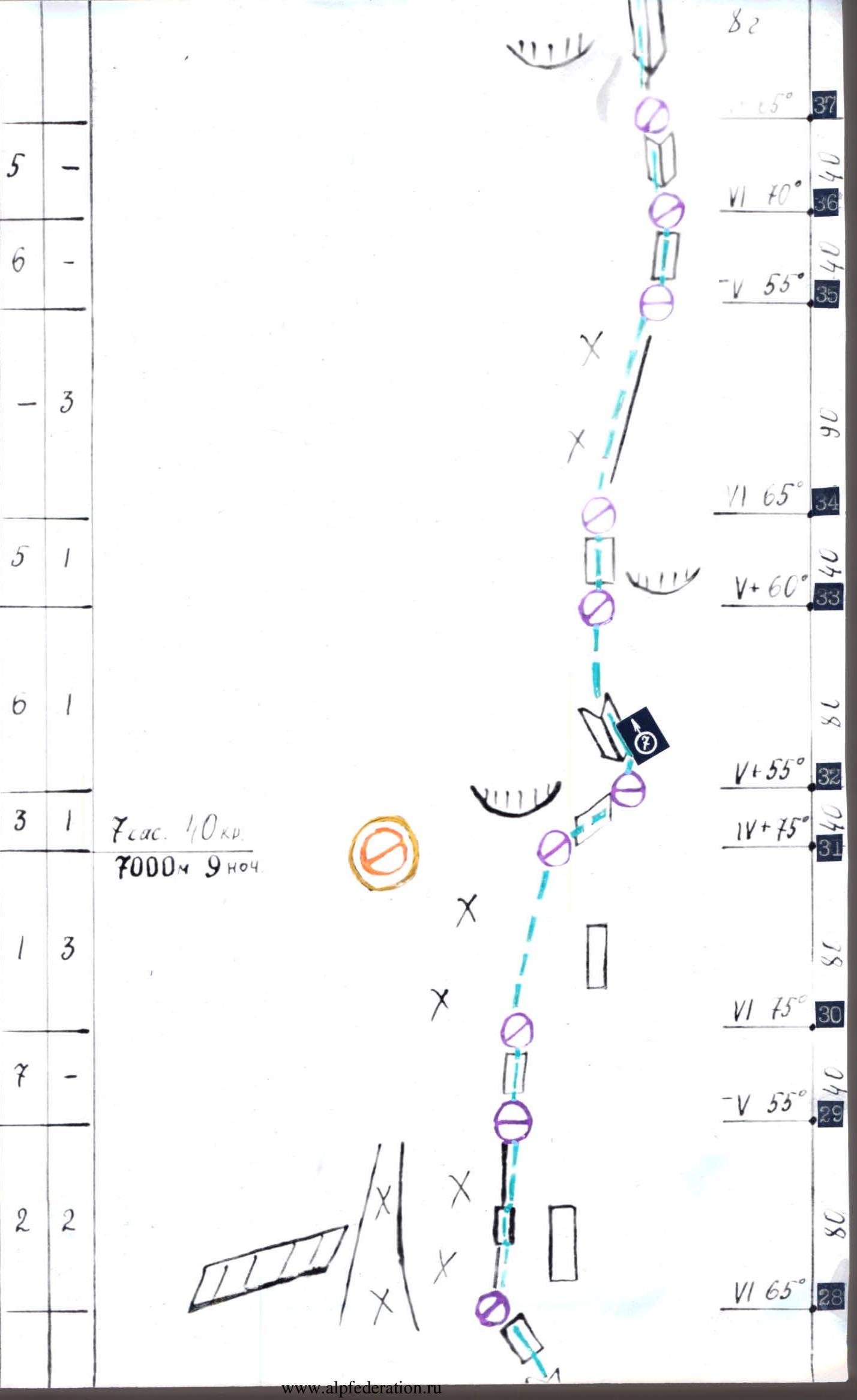
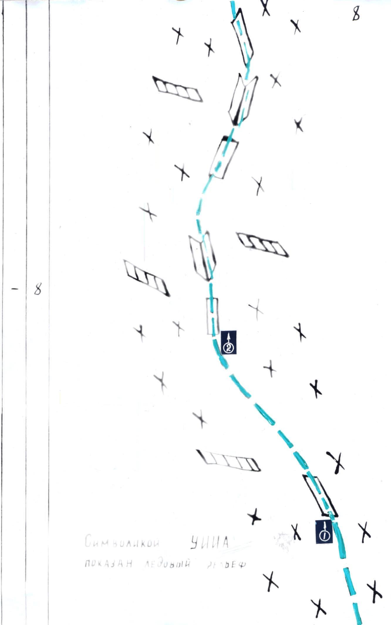
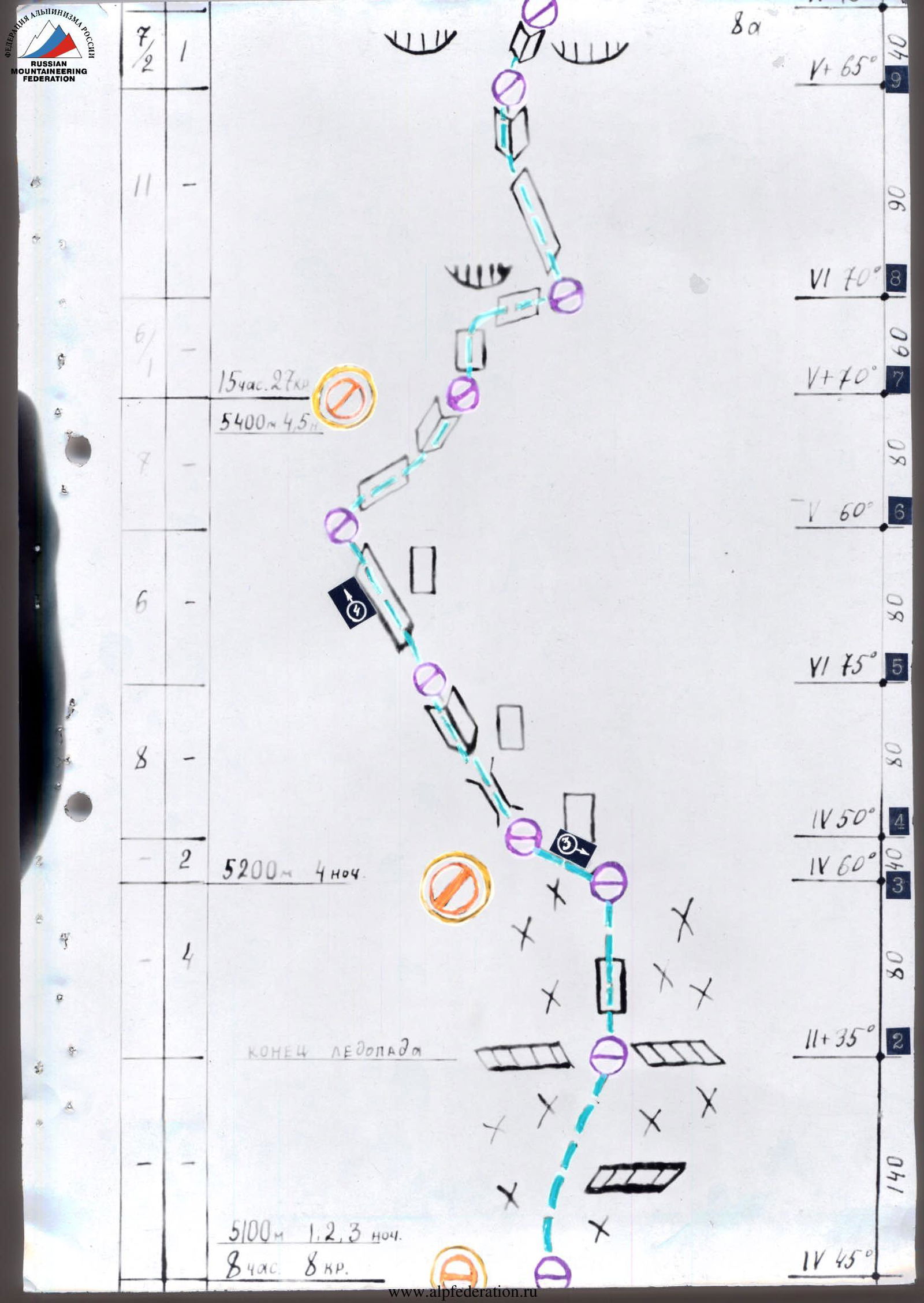
Route diagram in symbols
| Route | 69 hours |
| Descent | 9 hours |
| Total length | 269 cr. |
| 44 cr. (descent) | |
| Rock pitons | 218 pcs. |
| Ice pitons | 51 pcs. |
| Screw pitons | 3 pcs. |
| Category of difficulty | 6B category |
(Scale 1:2000)
Route description by sections
R0–R1. Movement through the icefall. The icefall is heavily broken and divided by a snow-ice cushion into two steps. The start of the ascent is in the central part. Move up to the exit to the snow-ice cushion — I step. Then — left-up through the entire cushion to the snow-ice counterfort. Along it, navigating through ice seracs, we reach the snow-ice shelf under a large ice wall. Left along the shelf to the end of the wall, we exit to the II cushion — II step. Upon exiting, there is a safe place for an overnight stay.
R1–R2. Move through the entire cushion, bypassing a large avalanche cone, and further to the bergschrund under the I rock triangle.
R2–R3. Steep ice slope. Under the rocks — a place for one tent.
R3–R4. From the overnight stay — left under the wall along the ice to the base of the chimney.
R4–R5. The right wall of the chimney is a smooth monolith, overhanging; the left — destroyed, unstable rocks. Filled with rime ice. Few cracks. In the upper part, it turns into an internal angle.
R5–R6. Left-up along a sloping shelf, along the overhanging monolithic rock. The shelf is heavily filled with rime ice.
R6–R7. Right-up along a steep shelf to the internal angle, then along it to a rock outcrop. A place for one tent (semi-reclining).
Sections R2–R7 were pre-processed by Smirnov — Moiseev — Suvita, Smirnov — Suvita — Khalitov.
R7–R8: Straight up — a complex monolithic wall with few holds. ITI was used. To the right — along a steep shelf with strongly smoothed rocks.
R8–R9: Left-up along an inclined slab. Rocks are strongly smoothed, rime ice. Then we pass through a steep internal angle.
R9–R10: Climbing the internal angle is complex, ITI is used. Sections R7–R10 were pre-processed by the Shkarban — Moiseev rope team.
R10–R11: A steep inclined shelf under an overhanging cornice leads to the right edge of the triangle. Rime ice. Climbing is very complex.
R11–R13: The edge represents rocks like "ram's foreheads." Covered with rime ice and snow. In the upper part, we organize overnight stays.
R13–R14: Rocks on the ridge are like "ram's foreheads." Then — right along the rock wall. A lot of fresh snow. Section R13–R14 was processed by the Suvita — Moiseev rope team.
R14–R15: Along the icefall. A dangerous place. Passed early in the morning and quickly.
R15–R17: Up along the ridge to a large brown wall. Rocks are heavily snowed. Very few cracks.
R17–R21: Traverse of a snow-ice slope under the cover of the wall of the II rock triangle to the top of the ice "tie," leading under the central part of the triangle. Ice is very hard. The Smirnov — Suvita rope team works ahead.
R21–R22: A rock wall leads to a steep inclined shelf going right-up. Climbing is complex.
R22–R23: Further — along the internal angle left-up. Steepness increases. The internal angle is filled with rime ice.
The Shkarban — Khalitov — Moiseev rope team works ahead.
R23–R24: Climbing along the shelf is complex, snowed. On the left — an inclined wall. On the right part of the shelf — an overnight stay. The section was first worked on by Smirnov — Suvita.
R24–R25: Further along the shelf, we exit to a rock-ice ridge.
R25–R26: The ridge is not very steep, местами filled with rime ice.
R26–R27: Cross right-up a wide shelf, a lot of snow.
R27–R28: An internal angle composed of strongly destroyed rocks. Then we go left-up along an inclined shelf.
R28–R29: We exit to a steep rock ridge. In the middle of the ridge — a rock wall.
R29–R30: The ridge rests against a steep rock wall. Large blocks, few holds.
On sections R24–R30, the Smirnov — Suvita rope team worked.
R30–R31: A rock wall leads to a ridge. Rocks are covered with snow, steep. At the end of the ridge, under a rock belt — an overnight stay (semi-reclining).
R31–R32: Right-up along an inclined slab. Rocks are heavily snowed.
R32–R33: A small internal angle. Rocks are destroyed. Ridge.
R33–R34: An indistinct ridge. A lot of snow. A rock wall. The Moiseev — Khalitov rope team works.
R34–R35: A steep snow ridge.
R35–R36: Right-up along a steep wall. Rocks are snowed. Complex climbing.
R36–R37: An internal angle. Snow-covered rocks. Complex climbing.
On sections R34–R37, Smirnov — Suvita work.
R37–R38: An internal angle. At the top, it widens, leading to an indistinct ridge. The ridge consists of destroyed, heavily snowed rocks. At the top, the ridge rests against a snow cornice. Passing the cornice, we exit to the summit ridge.
On the ridge, we set up a tent and move left along the ridge to the summit. The note is on the rocks on the southern side of the ridge, right on the main summit.
We descend to the tent — overnight stay. Descent along the western ridge through Peak V. Pshavela to the Diky pass and further — to the Zvezdochka glacier.
Equipment table
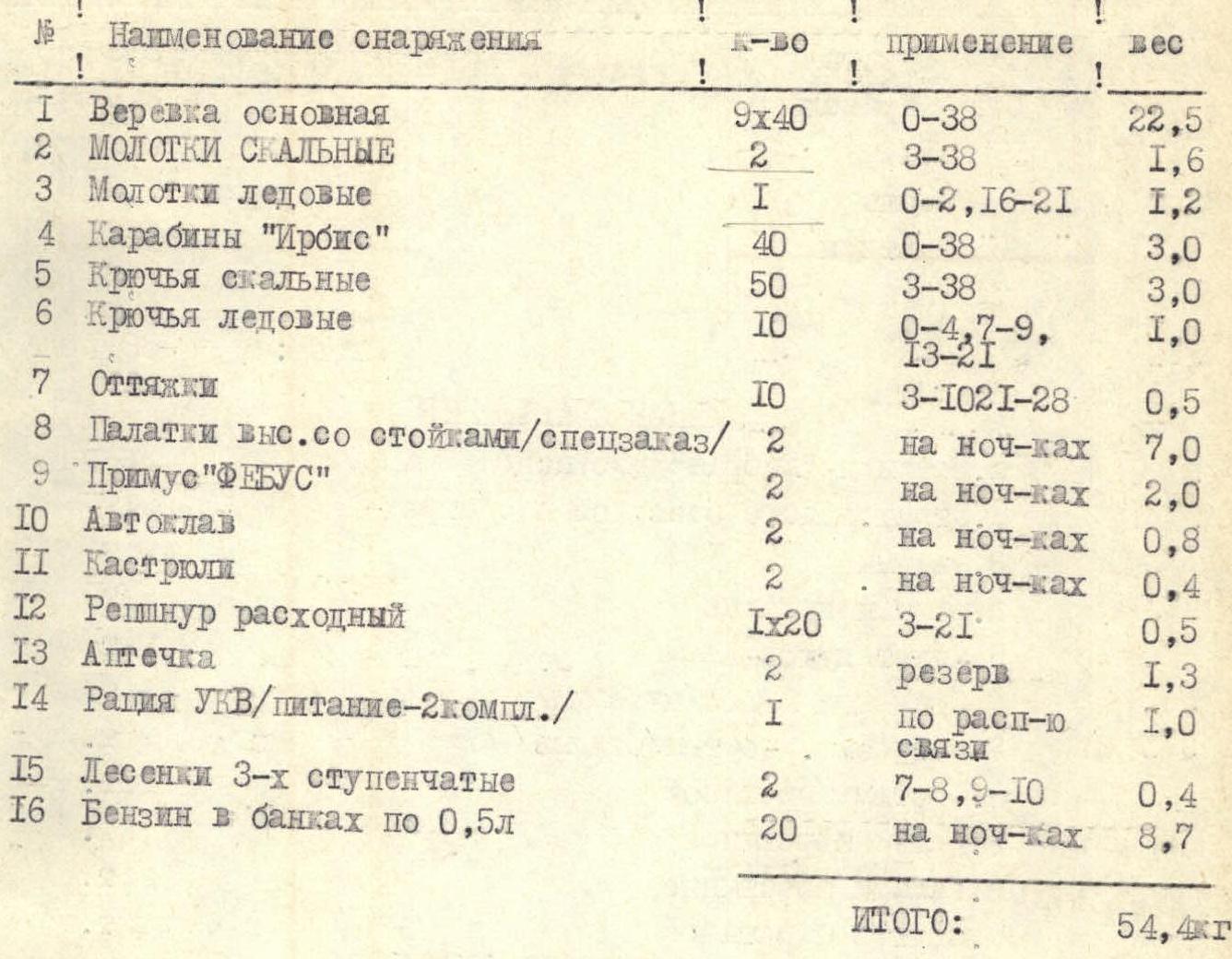
| № | Name | Quantity | Application | Weight (kg) |
|---|---|---|---|---|
| 1 | Main rope | 9×40 m | R0–R38 | 22.5 |
| 2 | Rock hammers | 2 pcs. | R3–R38 | 1.6 |
| 3 | Ice axes | 1 pc. | R0–R2, R16–R21 | 1.2 |
| 4 | "Ir-bis" carabiners | 40 pcs. | R0–R38 | 3.0 |
| 5 | Rock pitons | 50 pcs. | R3–R38 | 3.0 |
| 6 | Ice pitons | 10 pcs. | R0–R4, R7–R9, R13–R21 | 1.0 |
| 7 | Slings | 10 pcs. | R3–R10, R21–R28 | 0.5 |
| 8 | High-altitude tents with poles | 2 pcs. | for overnight stays | 7.0 |
| 9 | "Febus" stove | 2 pcs. | for overnight stays | 2.0 |
| 10 | Autoclave | 2 pcs. | for overnight stays | 0.8 |
| 11 | Cooking pots | 2 pcs. | for overnight stays | 0.4 |
| 12 | Spare reepschnur | 1×20 m | R3–R21 | 0.5 |
| 13 | First-aid kit | 2 pcs. | reserve | 1.3 |
| 14 | VHF radio station (power — 2 sets) | 1 pc. | for communication | 1.0 |
| 15 | 3-step ladders | 2 pcs. | R7–R8, R9–R10 | 0.4 |
| 16 | Gasoline in 0.5 l cans | 20 pcs. | for overnight stays | 8.7 |
| Total: | 54.4 kg |
Product table
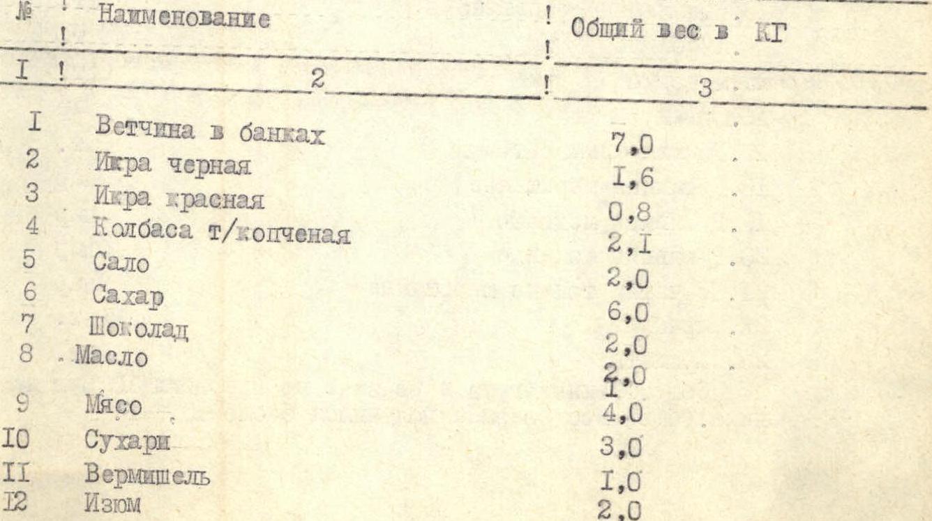
| № | Name | Weight (kg) |
|---|---|---|
| 1 | Canned ham | 7.0 |
| 2 | Black caviar | 1.6 |
| 3 | Red caviar | 0.8 |
| 4 | Smoked sausage | 2.1 |
| 5 | Lard | 2.0 |
| 6 | Sugar | 6.0 |
| 7 | Chocolate | 2.0 |
| 8 | Butter | 2.0 |
| 9 | Meat | 4.0 |
| 10 | Crackers | 3.0 |
| 11 | Vermicelli | 1.0 |
| 12 | Raisins | 2.0 |
| 13 | Dried apricots | 2.5 |
| 14 | Caramels | 2.0 |
| 15 | Tea | 0.5 |
| 16 | Salt | 0.3 |
| 17 | Ketchup | 0.4 |
| 18 | Onion | 0.5 |
| Total: | 38.7 kg |
Personal gear
| № | Name | Quantity |
|---|---|---|
| 1 | "Vibram" boots (double) | 9 pairs |
| 2 | Climbing harness with seat harness and self-belay | 9 pcs. |
| 3 | Climbing jammers | 9 pcs. |
| 4 | Down jackets | 9 pcs. |
| 5 | Down vests | 9 pcs. |
| 6 | Sleeping bags (down) | 9 pcs. |
| 7 | Windproof suits (nylon) | 9 pcs. |
| 8 | Woolen suits | 9 pcs. |
| 9 | Woolen underwear | 9 pcs. |
| 10 | Woolen gaiters | 9 pcs. |
| 11 | Woolen sweaters | 9 pcs. |
| 12 | Sunglasses | 9 pcs. |
| 13 | Helmets | 9 pcs. |
| 14 | Woolen balaclavas | 9 pcs. |
| 15 | Ice axes | 3 pcs. |
| 16 | Ice hammers | 6 pcs. |
| 17 | Crampons | 9 pairs |
| 18 | Aviation backpacks | 9 pcs. |
| 19 | Woolen gloves | 9 pairs |
| 20 | Fur gloves | 9 pairs |
| 21 | Leather gloves | 10 pairs |
| 22 | Thin woolen gloves | 9 pairs |
| 23 | Carabiners | 36 pcs. |
| 24 | Emergency gear | 8 pcs. |
The public load in the backpack did not exceed 10.3 kg per participant. The total weight of the backpack was about 15.6 kg.
 Photo # 1, section R0–R1, point 1
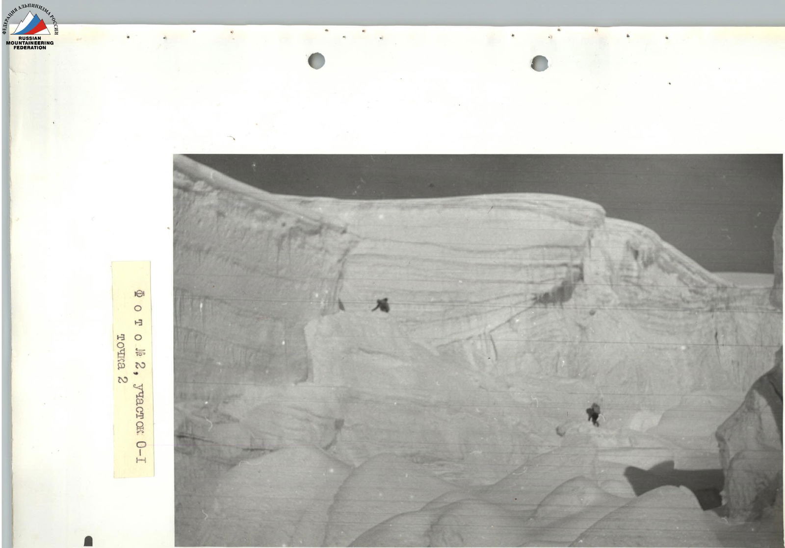
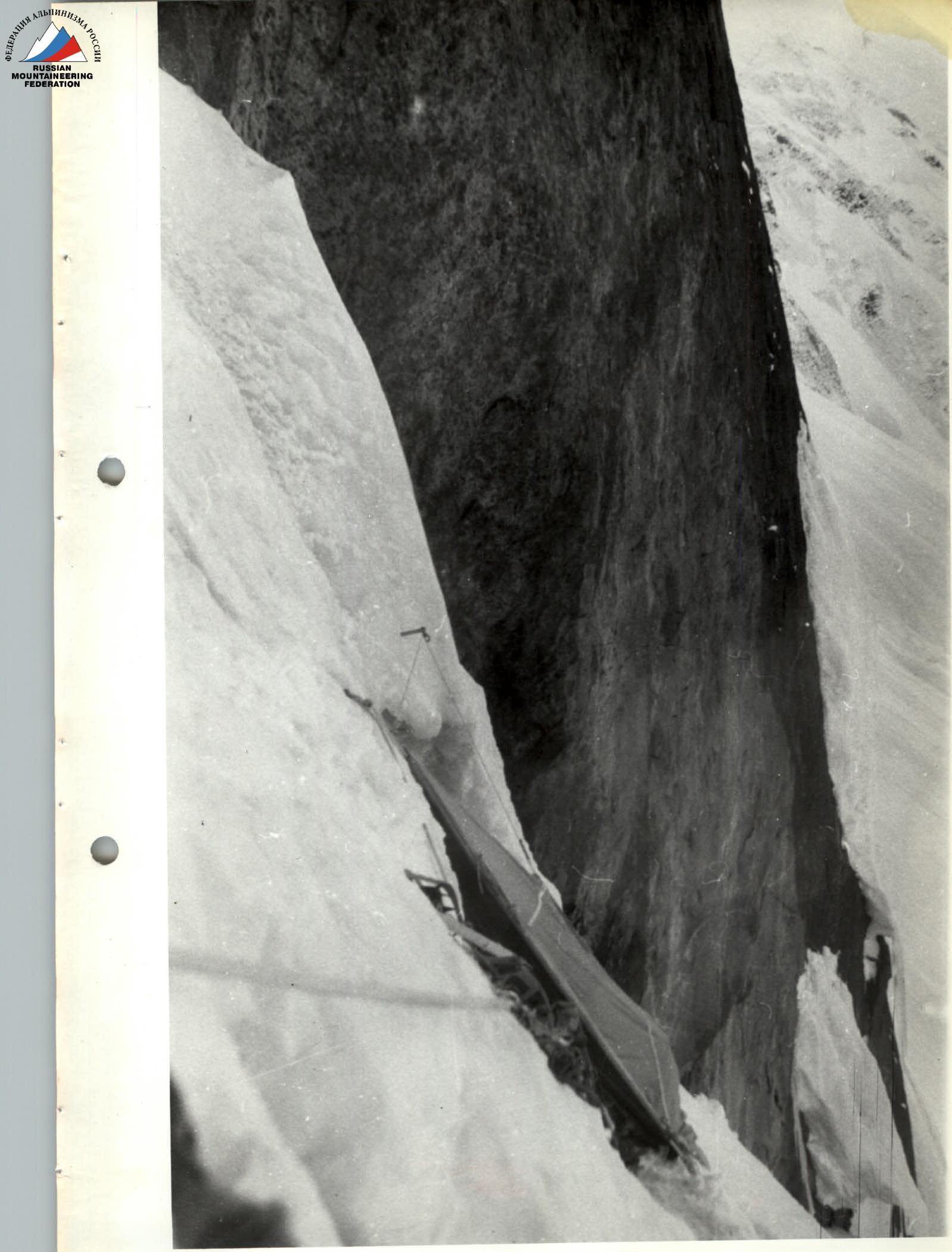 Photo # 3, section R3–R4, point 3

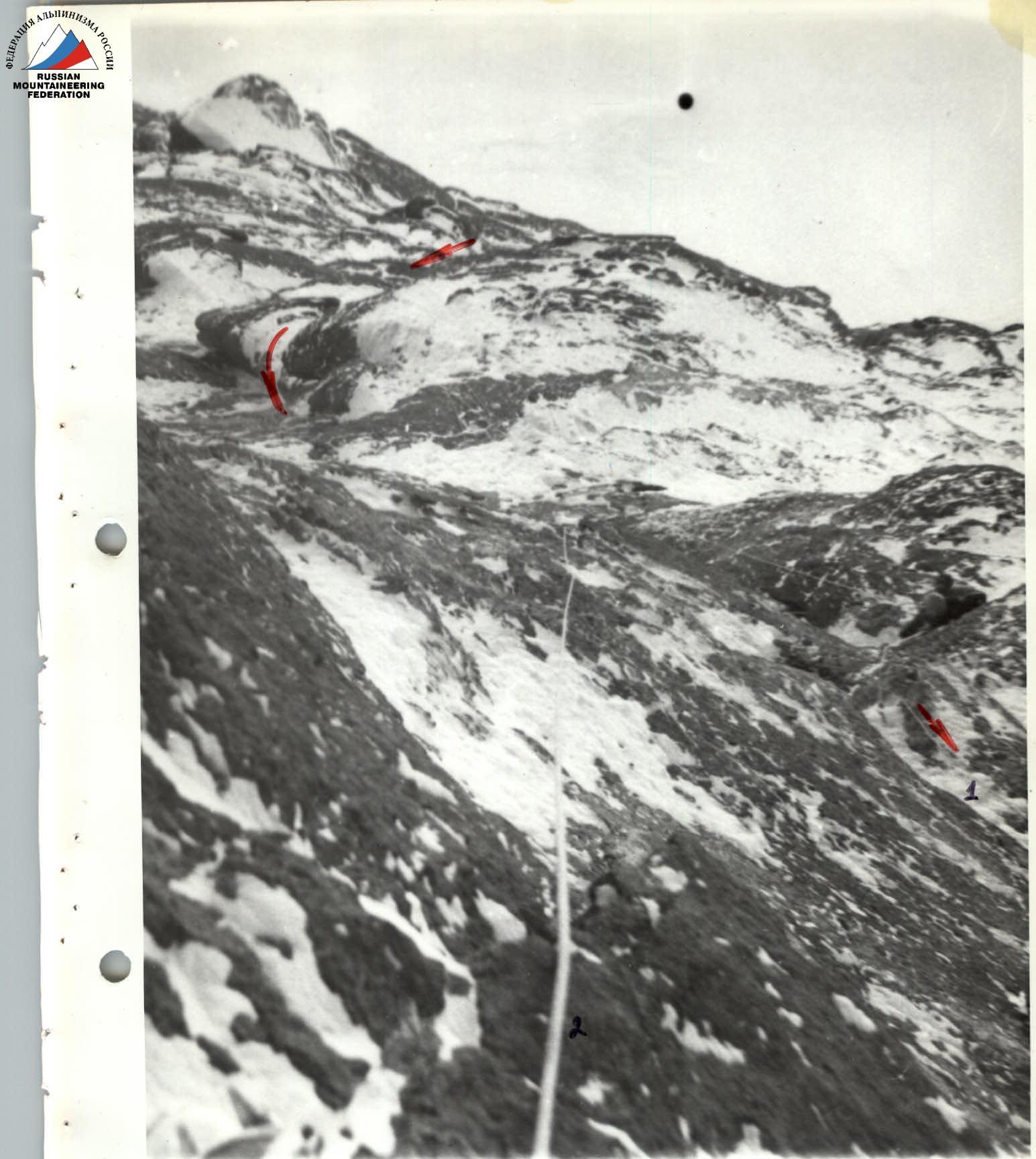
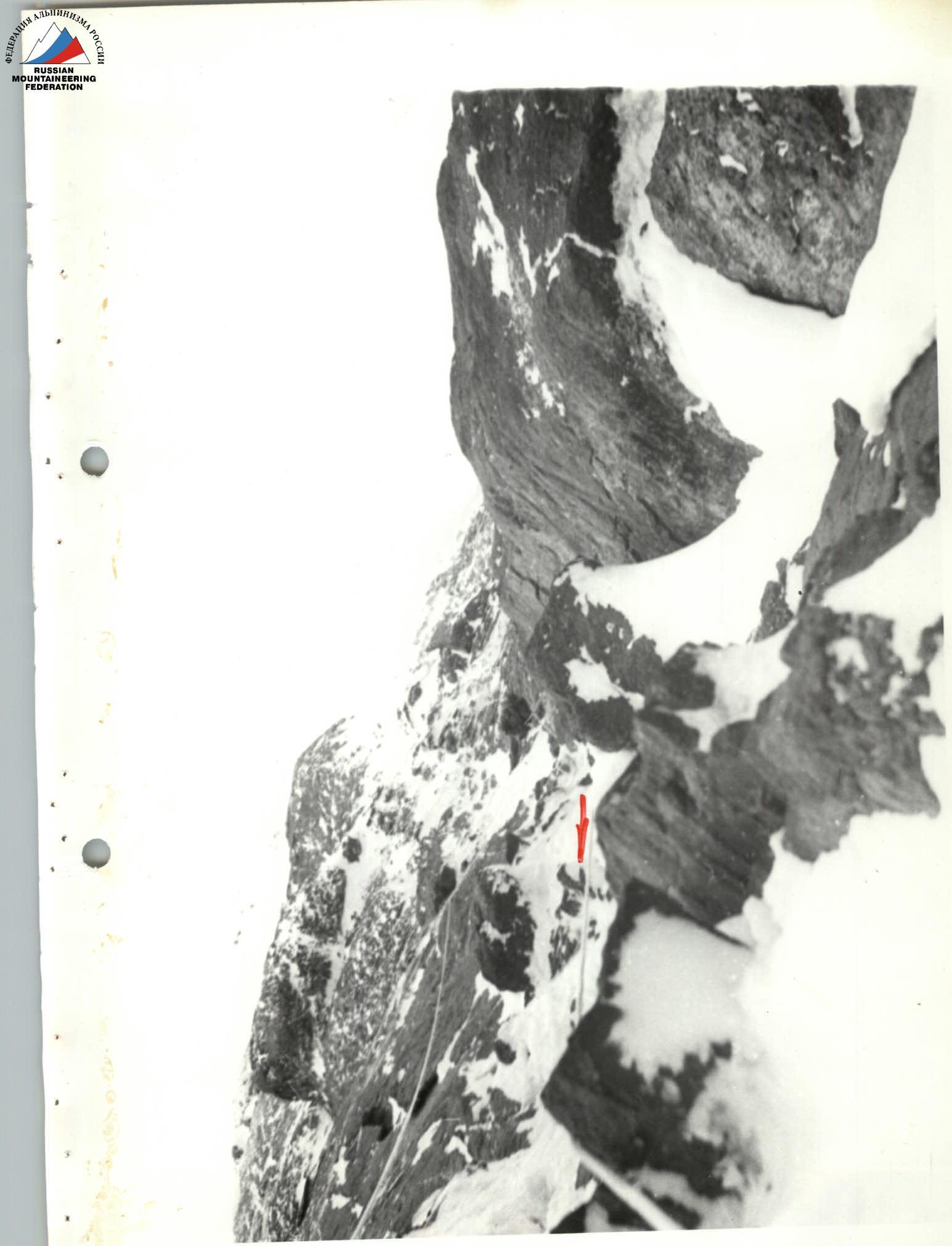 Photo # 5, section R10–R11 (shelf under the cornice), point 5
- Photo # 6, section R21–R22, point 6: 1 — ropes, 2 — retrieved rope.
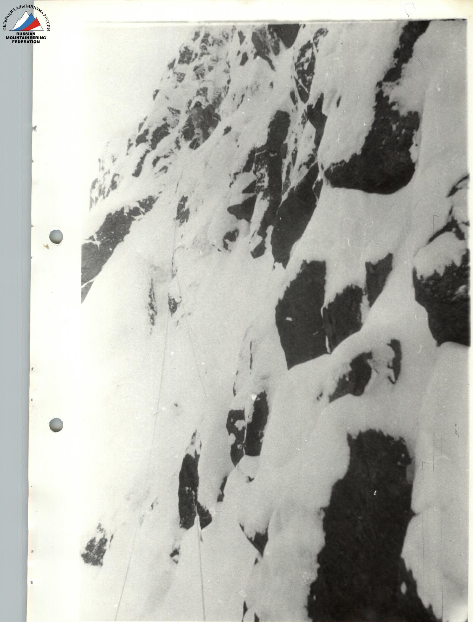 Photo # 7, section R32–R33 (on ropes), point 7
Summit!
Team coach: Honored Master of Sports, Honored Coach of the USSR
| 5000 m | 10 | |
| 5000 m | 13 (1) | 10.108.884.28.08.82 г |
| 5400 m | 17 (1) | 10.108.884.22.08.82 г – 23.08.82 г |
| 5600 m | 5 | |
| 5000 m | 4 (1) | 10.108.884.28.08.82 г |
| 5100 m | 1 (1) | 10.108.884.21.08.82 г |