Passport.
- Class: technical.
- Tian-Shan, Kokshaal-Tau.
- Peak Gornykh Voditeley (4730 m) via NW ridge.
- Proposed category: 2B, combined.
- Height difference: 500 m, length: 1500 m. Average steepness of the rocky part is 45°, snow and ice part is 30°.
- Pitons: rock - 0, ice - 0, chockstones - 2.
- Climbing time: 4 hours.
- Overnight stays: none.
- Leader: Boyko V.V., Master of Sports. Team members:
- Lebedev M.V., Candidate for Master of Sports.
- Lebedeva E.V., Candidate for Master of Sports.
- Shimokhin I.A., 1st sports category.
- Valikov E.A., 3rd sports category.
- Coach: Korsun A.G.
- Departure: July 29, 1998.
Return: July 29, 1998.
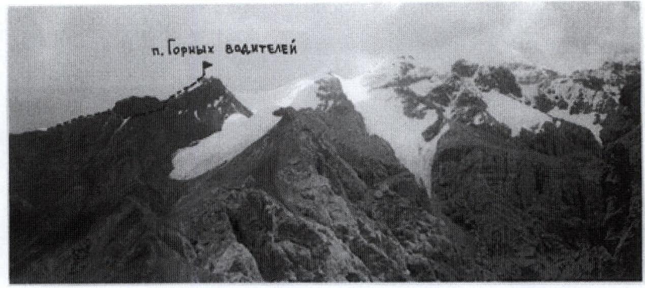
View of Peak Gornykh Voditeley from the slopes of Peak Chernogolovka.
Route description.
Peak Gornykh Voditeley is located opposite the usual location of the base camp under Peak Dankova, making it a convenient objective for training ascents. The peak was named after the drivers who transported our expeditions to the mountains in 1993, 1996, and 1998. Thanks to their skill and experience, we were able to successfully overcome:
- hundreds of kilometers of challenging mountain roads,
- dozens of kilometers of off-road terrain on the way to the base camp.
The total elevation gain from the base camp to the summit is approximately 1300 m. In the initial period of stay in the mountains, such a gain in a single day may be unjustifiably difficult. Therefore, it is convenient to make an approach to the pass located to the left of Peak Gornykh Voditeley (see photo), where there are suitable areas for overnight stays. Overnighting at the pass is advisable for the following reasons:
- it aids acclimatization,
- the ascent to the pass via the broad couloir leading to it is well visible from below and does not pose difficulties,
while the neighboring couloirs to the right,
 leading directly to the summit, narrow into canyons in their lower parts, and climbing rocks may be required there. The route begins from the pass and follows the ridge. A gendarme on the route is bypassed on the right, following inclined ledges.
The rocks here are partially broken, and protection is required. Thin pitons and chockstones of various sizes may be necessary.
To reach the ridge after bypassing the gendarme, it is necessary to overcome a 10-20-meter wall with easy climbing. Further (see photo), the movement proceeds along a broad, gentle ridge, first over rocks, then over snow. The ridge leads directly to the summit.
Pre-summit ridge.
View of Peak Gornykh Voditeley from the base camp.