Passport
- Class of technical ascents
- Kyrgyz Ala-Too, Aksay gorge
- Peak Svobodnaya Korea via the centre of the North face
- 6B
- Elevation gain 1140 m, length 1250 m. Length of sections with 5–6 difficulty category: 938 m. Average slope of the route 73°, main part (3710–4690) — 78°, including 6 difficulty category 80–85° (243 m), 87–95° (225 m).
- Pitons driven: rock: 126 (25 used previously), bolt: 4 (new) + 4* (previously driven), chocks: 22 (3 used previously), ice screws: 41.
- Team's total climbing hours 32.5 and 3 days.
- Overnights: 1st overnight bivouac sitting on rock ledges, 2 people per ledge; 2nd overnight bivouac sitting in a tent on a platform carved into an ice ledge.
- Leader: Viktor E. Polyak, Candidate for Master of Sports.
Participants:
- Ivan D. Plakushchev, Candidate for Master of Sports
- Valery F. Rashkin, Candidate for Master of Sports
- Alexander M. Minaev, Candidate for Master of Sports
- Coach: Viktor E. Polyak
- Approach to the route: July 13, 1984.
Summit: July 15, 1984.
Return: July 15, 1984.
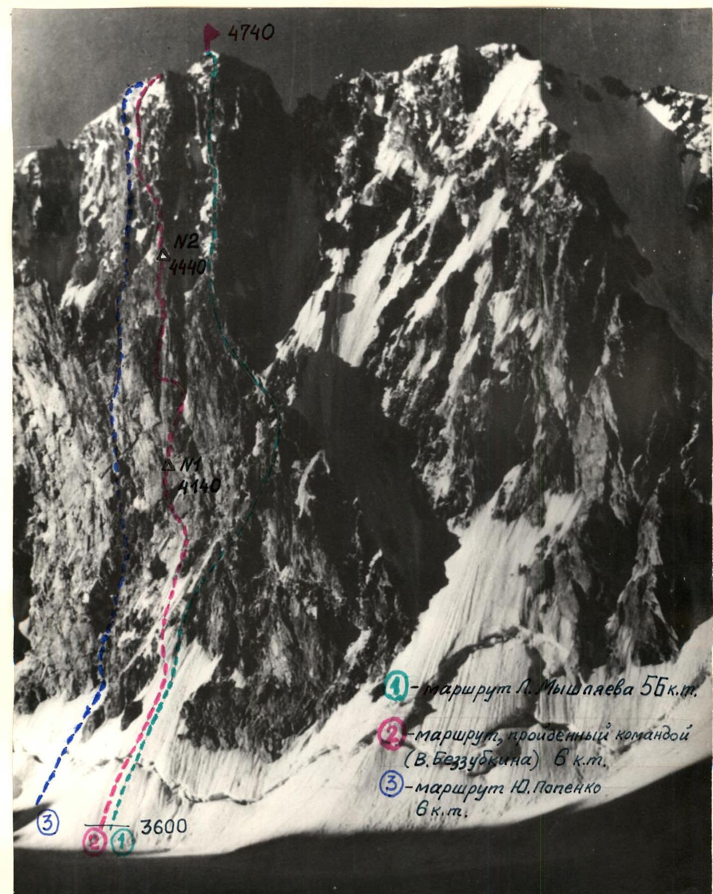
Photo from Aksay glacier on July 11, 1984, 10:00. Lens "Jupiter-8", focal length 50 mm, distance to the object about 2 km, shooting point No. 1 on the area diagram, elevation of the shooting point 3500 m.
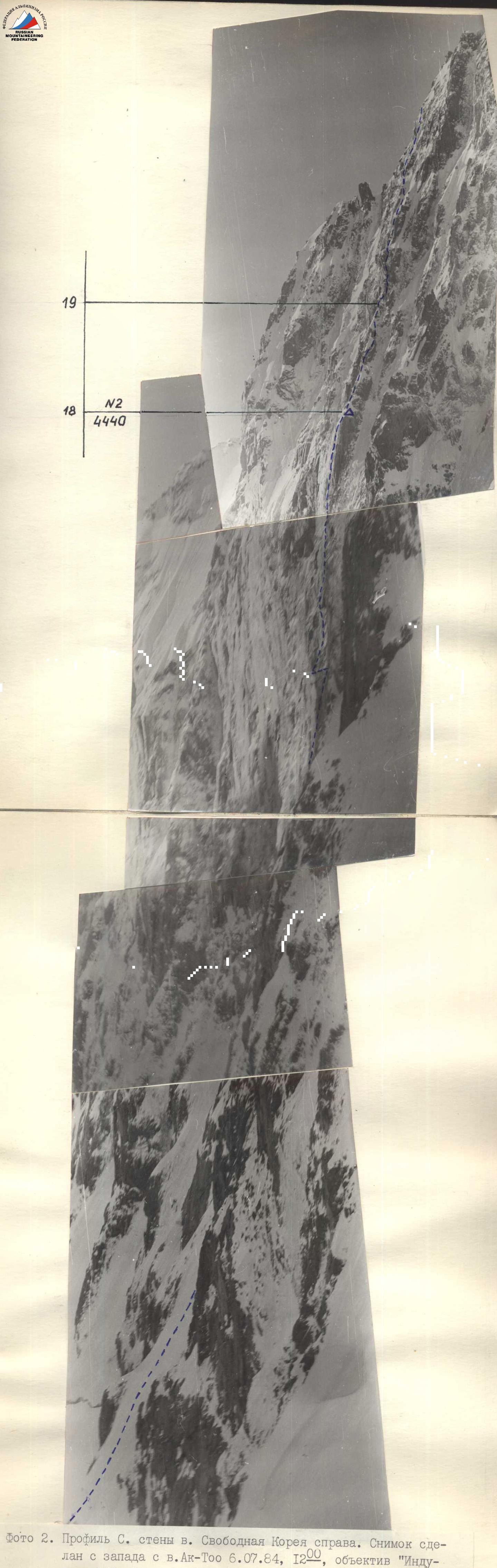
Photo 2. Profile of the N face of Peak Svobodnaya Korea on the right. Taken from the west from Peak Ak-Too on July 6, 1984, 12:00. Lens "Industar-50", focal length 50 mm, distance to the object about 1 km, shooting point No. 2 on the area diagram, elevation of the shooting point 4450 m.
Tactical actions of the team
The development of ascent tactics followed our usual path. Using available photographs of the wall and route description, we graphically determined the approximate elevation gains and distances between characteristic points of the route. Knowing our average speed of ascent on various routes, particularly on the route we completed this season on the NW wall of Peak Korona, we planned the overnight bivouac locations and the time required to pass key sections. Considering the route's condition, we deemed it optimal to complete it with two overnight bivouacs (assuming normal weather). Taking into account the complex weather conditions of the area and the large amount of ice on the wall, we also planned alternative routes with more overnight bivouacs and identified potential locations (start of sections R3–R4, R11–R12, and R13–R14, section R20–R21).
The nutrition plan on the route was two meals per day, with hot food and tea in the morning and evening. Considering the planned reserve days, we packed food for 5.5 days, at 400 g per person per day.
Tactical actions on the wall involved the following. Most of the route was climbed by teams of two: Polyak — Rashkin, and Plakushchev — Minaev. When setting up fixed ropes, the teams worked independently. The group worked with three backpacks, with the first climber going without a backpack. According to the tactical plan, the Polyak — Rashkin team led the main part of the route. As described, the route consists of three parts: 1) an ice slope with a steepness of up to 80° in the upper part approaching the rocks; 2) a rock overhang; 3) a counterfort with gendarmes transitioning into a rock-ice wall. In line with the tactical plan, Viktor Polyak led the lower ice part, Valery Rashkin worked on the rocks, and Ivan Plakushchev led much of the upper part.
The most significant rockfall danger was on the ice part of the route before reaching the rocks. Therefore, the team started the route at 2 AM, and the section up to the rocks was completed quickly — by 9:00 AM the group was on the rocks. The plan was that after reaching the first overnight bivouac location, the Rashkin — Polyak team would process subsequent sections. This was achieved in practice, as the group arrived at the planned overnight bivouac locations relatively early.
After reaching the first overnight bivouac location in the middle of section R9 (July 13, 1984, at 4:00 PM), the route was processed up to the end of section R12–R13; from the second overnight bivouac, during evening processing on July 14, 1984, two ropes were climbed on section R18–R19. This played a significant role the next day when, after snowfall during the night, movement on the rocks became significantly more complicated.
The second team of two focused on setting up bivouacs. The team brought two lightweight tents (each weighing about 1 kg) made of calendered nylon, which facilitated the setup of the first bivouac (sitting overnight on ledges, two people per ledge). Setting up the second bivouac was very labour-intensive, as the platform for the tent had to be partially carved out of the ice and partially constructed from snow.
Rappel lines were used in two places: sections R9–R10 and R10–R11, as well as R13–R14 and R14–R15. To facilitate the work of the first climber on steep sections and to cross overhangs, a ladder with a platform was used. On ice, the first climber worked with an ice axe and "ice fifis".
Throughout the route, stable radio communication was maintained with observers according to the schedule.
The tactical ascent plan was executed almost precisely, with some time saved.

* — use of previously driven pitons
| Section | rock | chocks | bolt | ice | First climber | Climbing hours | Length, m | Steepness | Difficulty category |
|---|---|---|---|---|---|---|---|---|---|
| R6 | 2 | 1 | Rashkin | 2.5 | 95° | 4 | |||
| R5 | 2* | 2 | Rashkin | 52 | 87° | 2 | |||
| R4 | 2 | 6 | Polyak | 50 | 80° | 6 | |||
| R3 | 19 | Polyak | 260 | 65–75° | 5 | ||||
| R2 | 2 | Polyak | 5 | 87° | 6 | ||||
| R1 | 1 | 1 | Polyak Rashkin | 140 | 55° | 4 | |||
| R19 | 3 | Plakushchev | 100 | 60° | 4 | ||||
| R18 | 5 | 2 | Rashkin | 10 | 35 | 85° | 5 | ||
| R17 | 11 | 1 | Rashkin | 55 | 90° | 6 | |||
| R16 | 9 | 2 | 1 | Rashkin | 20 | 85° | 6 | ||
| R15 | 1* | Rashkin | 3.5 | 95° | 6 | ||||
| R14 | 12 | 5 | 1 | Rashkin | 75 | 87° | 6 | ||
| R13 | 6 | 1 | Rashkin | 20 | 5 | ||||
| R12 | 3 | 3 | 1 | Rashkin | 45 | 87° | 5 | ||
| R11 | 19 | 2 | Rashkin | 45 | 90° | 6 | |||
| R10 | 2 | 1 | Rashkin | 8 | 85° | 6 | |||
| R9 | 14 | 3 | Rashkin | 14 | 22 | 60° | 5 | ||
| R8 | 7 | 2 | Rashkin | 25 | 90° | 6 | |||
| R7 | 5 | 1 | Rashkin | 15 | 87° | 6 | |||
| * On section R12–R13, a traverse was performed, so the section | |||||||||
| R23 | 2 | 1 | Plakushchev | 8.5 | 80 | 40° | 3 | ||
| R22 | 8 | 2 | 7 | Polyak | 125 | 83° | 6 | ||
| R21 | 1 | 1 | 2 | Plakushchev | 25 | 75° | 5 | ||
| R20 | 7 | 2 | Plakushchev | 40 | 85° | 6 |
Total climbing hours — 32.5. Pitons driven: rock — 126, chocks — 22, bolts — 8, ice screws — 41.
Route description by sections
Section R0–R1. Movement on a snow-ice slope. Everyone in crampons. The slope's steepness in the upper part before the bergschrund reaches 60°. Section R1–R2. Crossing the bergschrund requires particular caution: the ice wall is nearly vertical with very hard, sometimes glazed ice. Viktor Polyak leads. Section R2–R3. Movement on a steep ice slope (65°–75°) towards the ice "knife". As the lower part of the route is climbed at night for maximum safety, several landmarks were identified in advance, allowing the team to follow the shortest path without delays. The ice is hard, with large areas of glazed ice. Ice axe and "ice fifis" are used. Careful ice screw protection. Section R3–R4. A very steep section of glazed ice approaching the rocks. Movement towards the rocks on the shortest path, slightly to the right of the ice "knife". Steepness reaches 80°. Very challenging climbing, careful protection. Particular attention is required when transitioning to the rocks. Live rocks! Organization of a reception point for all team members. (Photo No. 4). Section R4–R5. According to the tactical plan, the lead climber in the first team changes on the rocks. Valery Rashkin takes the lead. Very challenging climbing under the first cornice. The belay point at the end of the section before the cornice is hanging (Photo No. 5). Section R5–R6. Extremely difficult climbing. The first cornice is crossed using ladders, including a ladder with a platform (Photo No. 6). Three previously driven bolt pitons are used. Other team members use étriers to exit onto the cornice. Section R6–R7. Movement on a smoothed right wall of an internal angle with very few holds. Climbing is very challenging. Section R7–R8. A steep, smoothed wall, with a crack filled with ice at the top, leading to a narrow, snow-covered ledge with a control cairn. No notes were found in the cairn, so we leave our own. On the ledge, a sitting bivouac can be organized; however, according to information from above, there are convenient platforms about 15–20 meters higher. Section R8–R9. Up and left along a crack filled with ice, then a series of rock walls lead to two triangular platforms (one is 2 meters above the other). Here, a bivouac is organized. Two people on each platform, sitting overnight. Still plenty of daylight, and the Rashkin — Polyak team proceeds to process the further route. Section R9–R10. An internal angle with smooth, holdless walls presents significant difficulties. A bolt piton is driven. From this section, the "rock finger" is visible on the right. We move right and up towards it (Photo No. 7). Section R10–Section R11. Very challenging climbing on a steep wall, then entry into a vertical internal angle with destroyed walls. Many live rocks; climbing requires great caution. Section R11–R12. Exit on a steep wall above the "rock finger", then vertically up along an ice-filled internal angle. Rock walls with ice and snow lead to a horizontal, narrow ledge. Section R12–R13. A challenging traverse left along the ledge leads to the base of a 75 m long internal angle. Reliable protection is required to avoid a "pendulum" fall. By 8:00 PM, the section is completed. Ropes are secured, and the second team of two descends to the overnight bivouac location.
On July 14, 1984, at 8:00 AM, the Rashkin — Polyak team continues to lead. They ascend via the fixed ropes to the end of the processed section.
Section R13–R14. Entry into an internal angle with steep walls, ending at a second cornice. The lower part of the angle's walls are destroyed. Rocks are covered with ice. Movement is initially on the left side of the angle, then a transition to the right side. A section of very challenging climbing on steep, smoothed rocks using artificial aids (a bolt piton is driven). In the upper part of the angle, climbing is on a crack filled with ice. When approaching the cornice (right to left and up) — wet rocks with ice (Photo No. 8).
Section R14–R15. Crossing the cornice on wet rocks using ladders is very challenging. Above the cornice, on steep rocks in a wide crack — the only protection point — a reception point is organized (Photo No. 9). On this section, backpacks are pulled up.
Section R15–R16. Challenging climbing on a steep, smooth wall, with a slight overhang at the top. Water flows down the wall; rocks are icy. A ladder with a platform is used. To the left, 5 meters away on the wall, bolt pitons are visible; as known from previous information, this was the overnight bivouac location of an Irkutsk group in 1982.
Section R16–R17. Exit into an internal angle with smooth walls. Movement is initially left and up, then right and up. Climbing is very challenging, with few holds. Exit onto a small ledge through an overhang.
Section R17–R18. The last section before reaching the counterfort — the location of the second planned overnight bivouac. The weather deteriorates. Steep walls composed of large rock blocks are climbed. Challenging exit; as in other places, étriers are used when moving team members.
Section R18–R19. Start of the counterfort. In the lower part of the section — an inclined snow-ice ledge. On the wall, on a bolt piton, a can with a note — a control cairn. Time is 6:30 PM — practically in line with the tactical plan. The first team, Rashkin — Polyak, proceeds to process the route further. The second team begins to prepare a platform for the tent — here, there's a possibility to gather everyone together. When processing the route, it becomes apparent that in all descriptions, the steepness at the start of the section is exaggerated. We make a correction to our scheme, adding a division into two sections with different steepness. By 8:00 PM, about two ropes are processed. After descending, we join the second team: building the platform requires a lot of time. Partially — near the rocks — it is carved out of the ice; the outer side is constructed from snow. After 1.5 hours of intense work, the tent is set up; one slope is pressed against the wall. The sitting overnight bivouac is ready. It snows all night. It's cold.
On July 15, 1984, at 8:00 AM, Plakushchev leads. Teams work in the composition: Plakushchev — Polyak and Minaev — Rashkin. We climb the fixed ropes; the snowfall significantly complicates movement.
Section R19–R20. Approach along a steep rock-ice slope to a "gendarmes". Then — a steep crack with smooth walls and a slight overhang at the bottom. Very challenging climbing. Backpacks are pulled up to the "gendarmes".
Section R20–R21. Along steep ice, a bypass of the next "gendarmes" is made on the left. There's a platform for protection at the top. Everyone is in crampons.
Section R21–R22. A steep ice-rock wall presents significant difficulties. Viktor Polyak leads on this section. Initially, movement is on an ice slope left and up, then entry into an internal angle formed by two rock ridges. In the angle, there's glazed ice. For protection, ice screws and rock pitons are used. Extremely challenging climbing. местами слой льда мал, требуется аккуратная страховка. The ridge is visible. The last 20 meters to the ridge (Photo No. 10) are led by Ivan Plakushchev.
Section R22–R23. Initially on a rock, then on a snow slope — exit to the summit. The group reached the summit at 4:20 PM (according to the tactical plan — 5:00 PM).
Descent from Peak Svobodnaya Korea towards Peak Ak-Too, and then into the Top-Karagai gorge.
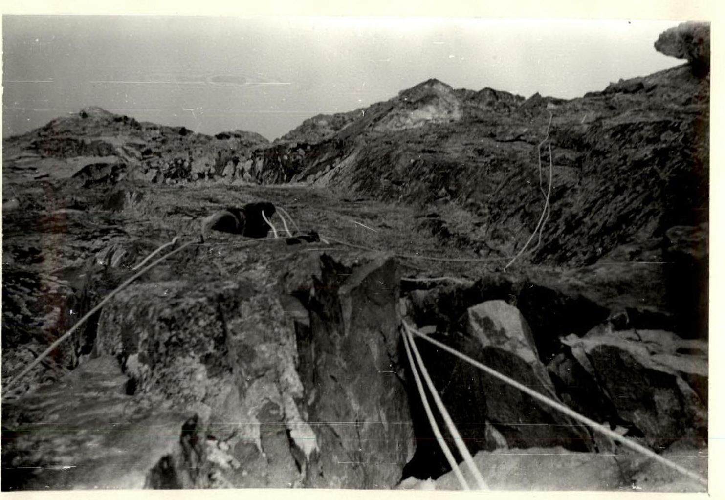
Photo No. 4. Sections R10 and R11. The "rock finger" is visible on the right.
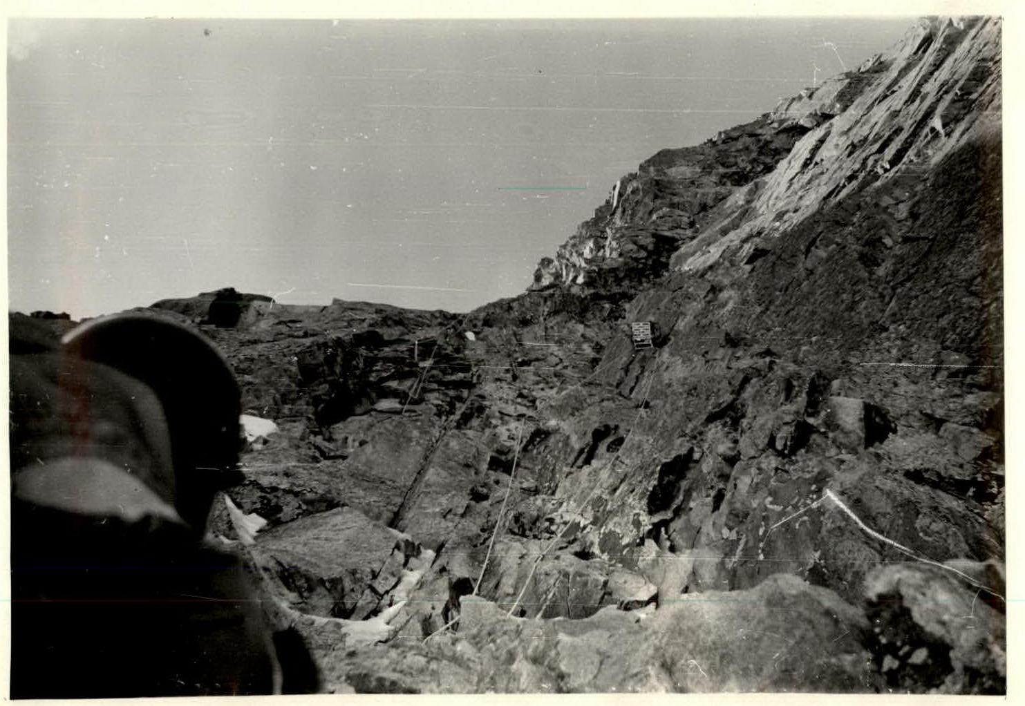
Photo No. 2. Movement on section R14, approach to the second cornice (section R15). A rope thrown by a previous group is visible in the upper left.