KIEV CITY COMMITTEE FOR PHYSICAL CULTURE AND SPORTS

REPORT ON THE ASCENT OF PIK SVOBODNAYA KOREYA VIA THE NORTH FACE
Kiev, 1969
 www.alpfederation.ru↗
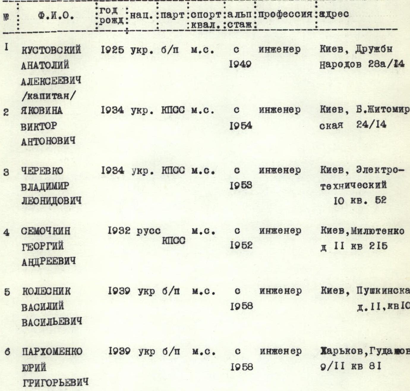
List of participants
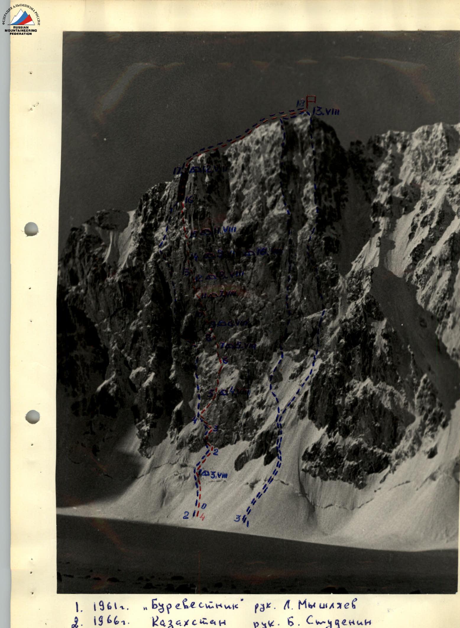
- 1961 "Burevestnik" led by L. Myshliaev
- 1966 Kazakhstan led by B. Studenin
- 1969 Krasnoyarsk led by V. Bezzubkin
- 1969 Kiev led by A. Kustovskiy
 August 2. The route begins from the Axsay glacier, via a snow-ice slope. In the upper part, the slope is intersected by a bergschrund that runs along the entire North face. The height of the starting point is around 3600 m. The average steepness of the snow-ice slope is 40–50°.
After a week of bad weather with daily snowfall and wind, clearings appear in the clouds. At 10:00, the team of A. Kustovskiy and G. Semochkin sets out to process the lower part of the route. Overcoming sections R0–R1 and R1–R2 does not pose significant difficulties. After hanging ropes up to the rocks, the team returns to the moraine under the Korona peak.
August 3. The weather is clear. At 7:00, the first team sets out on the route. Having passed the section processed the previous day, R0–R2, the team begins to move along the route under the base of the wall, following the edge of the rocks and ice. It takes about 2 hours to pass section R2–R3, which is an almost sheer wall of formed ice. To the right on the slabs, we see a piton left by Studenin's team, but we prefer to go through the steep ice. By 12:00, having moved along the edge of rocks and ice for about two more rope lengths (sections R3–R4), the team, as planned in the tactical plan, begins to descend. By this time, the rest of the participants have prepared a bivouac in the bergschrund, protected from rockfall and ice falling from the wall.
August 4. Along the processed sections R1–R4, the first team approaches the last piton hammered in the previous day by 9:00 and begins to move along rather steep rocks, clearing them of formed ice (section R4–R5). The rocks and ice here are protected by a small rock wall, and there is an opportunity to organize a safe bivouac for the entire group. Therefore, the first team hangs a rope further up the ice slope with small rock outcrops (section R5–R6), while the others are busy transporting backpacks and organizing a bivouac. This is the first overnight stay in hammocks, and unfortunately, not the last. All subsequent nights on the wall are spent in hammocks or, even less comfortably, sitting on platforms.
August 5. Having overcome the section processed the previous day, the first team approaches the internal corner (section R6–R7). This is the beginning of the most difficult and interesting part of the route. Very complex free climbing is required, and wedges and ladders are used. The upper part of the section overhangs, so by the time the first climber reaches the base of the wall, the rest of the group has time to gather at the start of the internal corner. Two of the climbers who have caught up climb up and, relieving the first team, continue moving upwards. The route goes along the wall along a weakly expressed internal corner (section R7–R8), in the lower part of which there is formed ice. After 4 hours of intense work, 16 pitons are hammered in, and one rope length of complex rocks is passed. But for today, it's down to point 7, where there is enough space for hammocks for everyone.
August 6. The weather is kind to us. It's still clear. And although the sun is on the wall for only about two hours a day, it's in the morning, so we manage to warm up our frozen boots and ourselves.
From the last piton hammered in yesterday, the choice of route is clear: before us is a wide sheer wall with a minimal number of holds, as well as numerous cornices. Therefore, we go straight up, bypassing cornices as much as possible, which doesn't always work.
After a slab covered with formed ice (section R8–R9), we come up against a two-meter cornice, which we pass with the help of pitons and a platform.
On this day, having moved 20 m along the sheer wall, the first team spends the night at point 10. We can hear the voices of the rest of the participants gathered at point 9.
There is no water on the entire wall. We have to melt ice, and having two "Febus" devices greatly facilitates food preparation.
August 7. Even during observations from below, section R10–R11 seemed to be one of the most complex. And we were not mistaken. Negative steepness, smooth rocks combined with overhanging "live" rock blocks - this is the characteristic of this part of the route.
At the end of the day, having overcome a small cornice, the first team reaches an inclined 70-degree slab covered with formed ice - from below, it seemed like a convenient place for a tent.
And again, a separated overnight stay
August 8. The pace of movement slows down somewhat due to the fact that a significant part of the pitons, carabiners, and ropes are still in use for organizing belays and movement of group members along section R9–R11. Nevertheless, on this day, the first team passes two rope lengths of very complex climbing along an internal corner with an overhanging right part (section R11–R12).
August 9. It's cold in the morning. The sun shines through haze. Apparently, the weather is deteriorating. However, the sheer wall and traverse under a cornice on section R12–R13, which, among other things, required the use of 10 pitons, do not allow us to gain height quickly. On this day, we pass another 60 m along the internal corner and, seeing the weather deteriorating, gather together at point 14. The concept of "together" is relative: three people spend the night in hammocks, and three - on platforms, sitting. But still together.
August 10. Our concerns about the weather are confirmed. Fog. Very cold. From the south, from the direction of Top-Karagai, black ragged clouds are continuously blowing in. Snow grains are falling. All this ends with a strong thunderstorm by the end of the day. Around us, a river of snow forms, flowing down the wall. Between thunderclaps, we hear the rumble of stones flying down the couloirs bordering our wall. We comfort ourselves with the thought that the route was chosen correctly, and nothing will fall on our heads. By midnight, the thunderstorm, having rumbled, moves further north, and although the familiar lights of the city of Frunze are not visible, it's clear that the bad weather is ending.
August 11. Everything is covered in a crust of ice. Rocks, our equipment, clothing - everything is frozen. A lot of time is spent preparing the first team for the exit on the route. The nature of the route has changed: instead of sheer rocks, smooth slabs covered with formed ice prevail.
Having overcome an ice groove, we reach the base of an ice couloir along the rocks (section R14–R15). The ice is extremely hard; the crampons of the first climber barely leave marks. We have to constantly cut steps.
In the ice couloir (section R15–R16):
- we use ice axes as artificial aids;
- the ice is very steep.
But it's clear that the summit is near. When securing the rope at point 15, to the left, about ten meters away, we notice a piton with a carabiner left by Studenin's team.
August 12. After section R15–R16, the ice couloir narrows into a crack filled with formed ice. In many places, we move as if in a chimney. Climbing is quite complex. We constantly encounter old pitons left behind.
In the upper part of the crack, we turn left onto the wall and reach the ridge by evening. Finally, a lying-down overnight stay!
August 13. In the morning, we fully enjoy the comfort provided by the southern slopes of the ridge. Everything is pleasant - the panorama, sun, water, tea. Therefore, we set out late.
After 1.5–2 hours of simultaneous movement along the ridge, we reach the summit at 14:00. The descent from the summit into the Top-Karagai valley takes several hours.
Assessment of the route and actions of participants
The route passed is saturated with sections requiring maximum effort and high technical skill. Throughout the route, there are practically no:
- places for overnight stays,
- places where one can relax and psychologically rest.
The lower part of the route - rocks like "ram's foreheads" with a minimal number of holds, mostly covered with formed ice. The average steepness is 45–55°. Starting from 15:00 to 16:00, when the sun warms up the pre-summit slopes, the route on this section becomes objectively dangerous due to rockfall. At this time, the group should be in a reliable shelter.
The middle part of the route - the wall itself - has a steepness of 80–90° with individual overhanging sections and a large number of cornices. This section is safe.
The last third - smoothed slabs of a "tiled" structure, turning into a crack with sheer walls in the upper part. The entire section is covered with formed ice. It is also safe from rockfall.
The entire route is characterized by "jaggedness," expressed in a constant alternation of sections requiring different technical techniques to overcome. Frequent "reconfiguring" disrupts the rhythm of movement and further complicates the passage of the route.
For the passage of the route, in addition to standard equipment, the presence of platforms and hammocks is mandatory. Organizationally, maximum autonomy of each participant in terms of food and overnight stay is required.
The group is a cohesive collective that has worked together for 6–8 years and has experience in passing walls of a similar class. The exit on the route was preceded by significant organizational work and thorough physical preparation. This contributed to the successful passage of the declared route.
According to the group members, the route corresponds to category 6B.
Team captain - A. Kustovskiy.
Team coach - I. Polevoy.
On section R10–R11
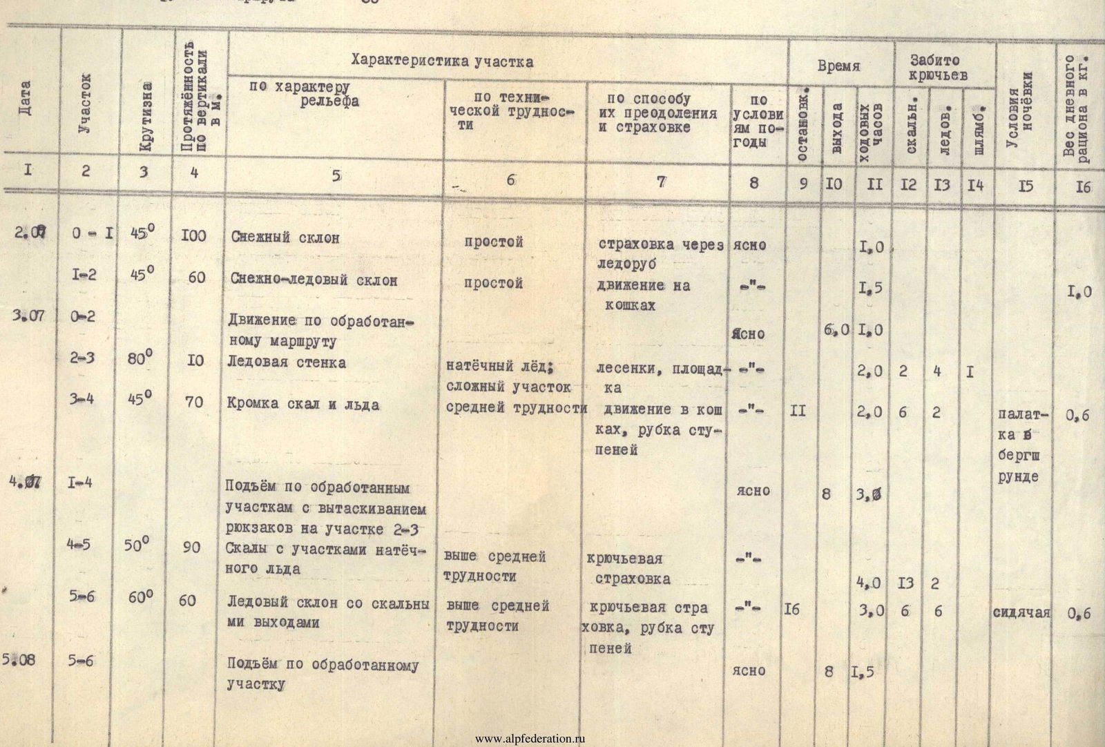
Table of main characteristics of the ascent route to Pik Svobodnaya Koreya via the North Face
Height difference of the route 1150 m. Including complex sections 600 m. Steepness of the route 80°
| Date | Section | Steepness | Vertical length in m. | Characteristics of the section | Time | Pitons driven | Overnight conditions | Weight of daily rations in kg. | |---|---|---|---|---|---|---|---|---|---| | | | | | by relief character | by technical difficulty | by method of overcoming and belay | by weather conditions | stops | exit | walking hours | rock | ice | piton | | | | 2.07 | R0–R1 | 45° | 100 | Snow slope | simple | belay via ice axe | clear | | 1:00 | | | | | | | | R1–R2 | 45° | 60 | Snow-ice slope | simple | movement on crampons | -"- | | 1:30 | | | | | 1,0 | | 3.07 | R0–R2 | | | Movement along processed route | | | Clear | | 6:00 | 1:00 | | | | | | | | R2–R3 | 80° | 10 | Ice wall | formed ice, complex section | ladders, platform | -"- | | 2:00 | 2 | 4 | 1 | | | | R3–R4 | 45° | 70 | Edge of rocks and ice | medium difficulty | movement on crampons, step cutting | -"- II | | 2:00 | 6 | 2 | tent in bergschrund | 0,6 | | 4.07 | R1–R4 | | | Ascent along processed sections with pulling up backpacks on section R2–R3 | | | clear | | 8:00 | 3:00 | | | | | | | | R4–R5 | 50° | 90 | Rocks with sections of formed ice | above medium difficulty | piton belay | -"- | | 4:00 | 13 | 2 | | | | | R5–R6 | 60° | 60 | Ice slope with rock outcrops | above medium difficulty | piton belay, step cutting | -"- 16 | | 3:00 | 6 | 6 | sitting | 0,6 | | 5.08 | R5–R6 | | | Ascent along processed section | | | Clear | | 8:00 | 1:30 | | | | | | | 5.08 | R6–R7 | 90° | 50 | Internal corner with overhanging exit | very difficult climbing | use of artificial aids | clear | | | 4:00 | 15 | | | in hammocks | 0,6 | | | R7–R8 | 80° | 30 | Wall with weakly expressed internal corner | complex climbing | partly ladders | -"- 18 | | 4:00 | 16 | | | | | | 6.08 | R7–R8 | | | Ascent along processed section and pulling up backpacks | | | -"- | | 8:00 | 4:00 | | | | | | | | R8–R9 | 70° | 30 | Slab with formed ice leading under cornice | complex climbing | ladders | -"- | | | 3:00 | 9 | 4 | | | | | R9–R10 | 90° | 20 | 2-meter cornice, sheer wall | very complex climbing | ladders, cornice on platform | -"- 18 | | 4:00 | 11 | | 7 | in hammocks | 0,6 | | 7.08 | R9–R10 | | | Ascent along processed section | | | -"- | | | 2:00 | | | | | | | | R10–R11 | 95° | 60 | Overhanging smooth wall with cornices, exit to slab covered with formed ice | very complex climbing | platform, ladders | -"- 18 | | 7:30 | 17 | 2 | 14 | in hammocks | 0,6 | | 8.08 | R11–R12 | 80° | 80 | Inclined internal corner with overhanging right side | very complex climbing | free climbing, 2 ladders | -"- 18 | 10 | 8:00 | 19 | | 1 | in hammocks | 0,6 | | 9.08 | R12–R13 | 90° | 40 | Sheer wall, traverse under cornice | very complex climbing | platform, ladders, partly free climbing | | | 8:00 | 4:00 | 11 | | 10 | | | | | R13–R14 | 70° | 60 | Internal corner with overhanging upper part of "live" blocks | very complex climbing | free climbing | weather deteriorating. 18 | | 6:00 | 20 | | | in hammocks and on platforms | 0,6 | | 10.08 | | | | Weathering bad weather | | | thunderstorm, blizzard | | | | | | | | | | 11.08 | R14–R15 | 70° | 60 | Ice groove with rock outcrops | complex climbing | step cutting, use of ice pitons as artificial aids | clear | | | 9:00 | 4 | 9 | 6 | | | | | R15–R16 | 60° | 70 | Ice couloir | complex climbing | | -"- 18 | | 5:00 | 4 | | 12 | sitting on platforms | 0,6 | | 12.08 | R15–R16 | | | Passage of processed route | | | -"- | | | 10:00 | 2:00 | | | | | | | | R16–R17 | 70° | 80 | Crack filled with formed ice, exit along wall to ridge | complex climbing | free climbing, ladders on exit | -"- 19 | | 7:00 | 12 | | | sitting on slab | 0,6 | | 13.08 | R17–R18 | 20–30° | 180 | Ridge, destroyed rocks | simple climbing | simultaneous movement | -"- | | | 12:00 | 2:00 | | | | | | | | R18–R19 | | | Descent into Top-Karagai valley | 2 category | | | | | | | | | | | | | | TOTAL: | | 1150 | | | | | | | 85:30 | 172 | 36 | 33 | | | |