PASSPORT
-
Ice and snow ascent category.
-
Tian-Shan, Kyrgyz range, Aksai spur.
-
Peak Svobodnaya Korea via north wall couloirs (Barber's route), 4740 m.
-
Proposed category 5B difficulty, second ascent.
-
Height difference — 680 m, length — 865 m. Length of category 5B difficulty — 520 m. Average steepness of the main part of the route — 52° (4060–4660 m), including sections of 51° (4120–4420 m), 52° (4420–4580 m), 59° (4580–4660 m).
-
Pitons driven: rock 1 ice 340
-
Team's climbing hours: 12.5 hours and days — 1.
-
Overnight stays: none.
-
Leader: Vitaly M. Guselnikov, Candidate Master of Sports Participants:
- Vyacheslav A. Sidorenko, Candidate Master of Sports
- Vladimir I. Shakleev, Candidate Master of Sports
- Valentin A. Tenenev, Candidate Master of Sports
-
Coach: Nikolai A. Shevchenko, Master of Sports of the USSR.
-
Route entry on July 7, 1986. Summit on July 7, 1986. Return on July 7, 1986.
-
Organizing body: Physical Culture and Sports Committee under the Altai Regional Executive Committee.
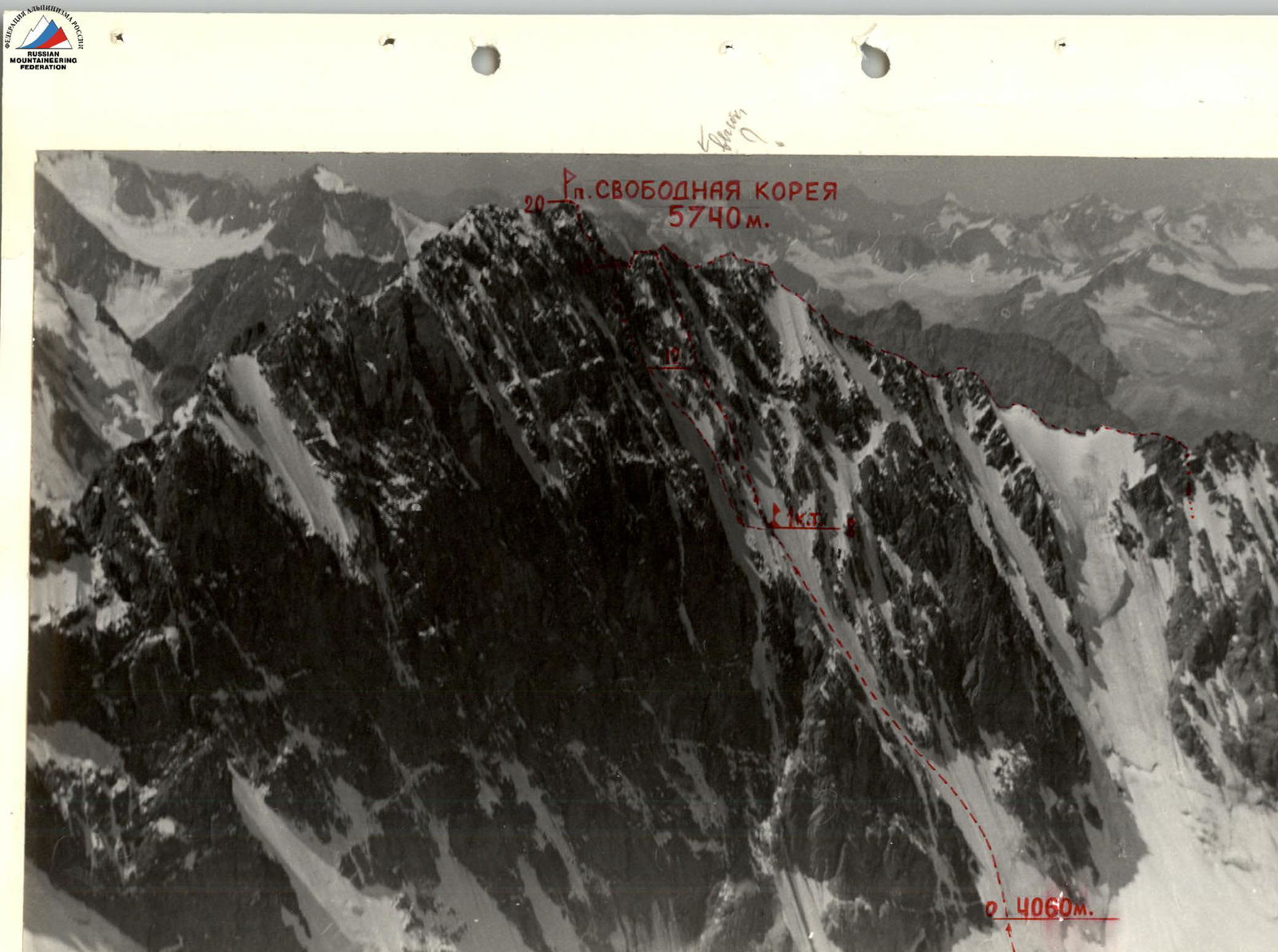
General photo of the summit. —-- Barber's route. —- - Artamonov's route. Taken by "Lubitel" from a helicopter, altitude about 5 km.
Team's Tactical Actions
Safe passage of the route required two main conditions: working in the couloirs until 14:00–15:00 and minimal time spent in potentially hazardous couloirs. The following tactical actions ensured the fulfillment of these conditions.
- Start of work on the route — 2:00 AM on July 7, 1986.
- Passage through the lower U-shaped couloir by two autonomous parallel rope teams: Tenenev — Sidorenko and Guselnikov — Shakleev (sections R1–R8).
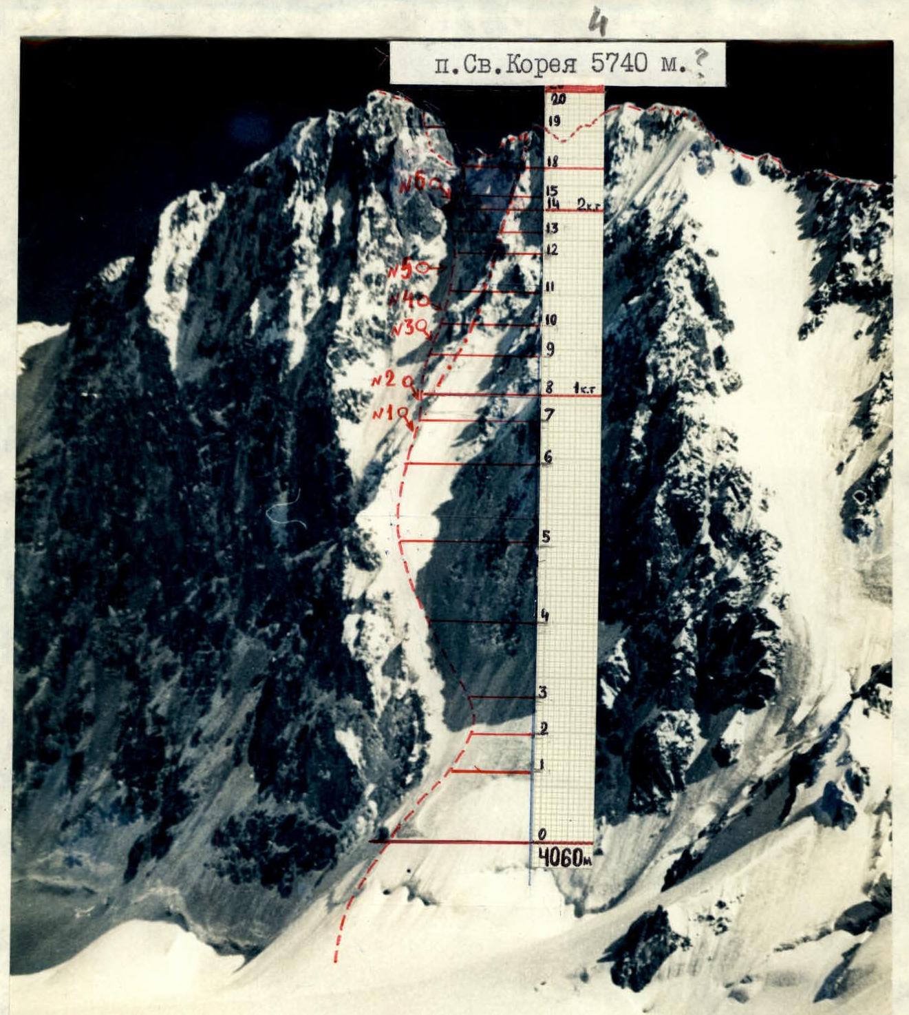
- Photo #1 — section R6–R7, 6:30 AM.
- Work on double 20-meter ropes with constant change of leaders in the rope teams. This ensured continuous movement of the rope teams at the same pace and upward movement along safe directions for the second climber.
- This work allowed the team to adhere to the time schedule and reach the ridges separating the upper and lower couloirs (section R6) by 7:00 AM.
- Half-hour rest at the 1st control point — section R8, 20:20.
- Approach to the 1st control point — photo #2.
- Change in the movement pattern in the upper couloir (sections R8–R18). Guselnikov — Shakleev rope team leads. Movement along the right side of the upper couloir with change of leader.
- Pitons are left for the Tenenev — Sidorenko rope team.
- Sections R9–R12, photos #3–5.
- The second rope team, following the pitons left by the first, ascends and crosses the couloir left-upwards into a "pocket" towards the rocks on the left side of the couloir (sections R12–R14).
- The second rope team approaches along the pitons of the first. At 11:30, 2nd control point — a location not exposed to rockfall from the summit tower or the "throat" of the upper couloir.
- Then, right-upwards to the entrance of the "throat". Steepness up to 65–70°.
- Section R15–R17, 35 m long, photo #6 — V. Tenenev working.
- Then, rightwards along broken rocks until reaching a snowy saddle.
- After Tenenev reaches the saddle, the second rope team Guselnikov — Shakleev starts moving from the 2nd control point along the pitons of the first team up to section R17.
- Then, right-upwards 40 m of fixed ropes to the saddle.
- At 13:35, work in the couloirs is completed — reaching the saddle between the summit tower and the ridge.
- At 14:35, the team reaches the summit of Peak Svobodnaya Korea (4740 m).
Descent into Top-Karagay gorge began after the last radio contact at 16:30. Ala-Archa alpine camp — 20:30 on July 7, 1986.
This scheme ensured a safe passage of the route because:
-
The lower couloir was traversed at night by parallel rope teams.
-
The upper couloir was traversed before being exposed to sunlight and on the right side of the couloir's axis (paths of probable ice, snow, or rockfall) under the protection of the right side rocks.
-
The correctly chosen pace of movement ensured continuous movement on ice.
-
Group rest — in safe locations — control points #1 and #2.
-
Passage through the "throat" of the upper couloir by separate rope teams: the second rope team Guselnikov — Shakleev started moving after Tenenev reached the snowy saddle between the summit tower and the ridge.
-
Weather conditions were favorable for the ascent. The team waited several days for a "weather window" without precipitation. An earlier departure on the previous day was canceled due to a weather forecast received from the Climbing and Sports Council.
In case of weather deterioration, the plan was: a) to wait at the 1st control point, b) to divert to Artamonov's route, or c) to descend via the ascent route in the lower couloir. Communication was maintained via radios, and visually from 5:30 AM until the summit, allowing for adjustments to the movement and tactics by the team coach N.A. Shevchenko at any moment.
Route Description by Sections
We approach the bergschrund — the start of the route — 4060 m, along snow with steepness up to 45°. Sections R1–R8. Average steepness 51°. Clean summer ice alternates with snow up to 15–20 cm, and firn up to 5 cm. Protection via ice screws. We work in autonomous rope teams, moving in parallel directions approximately at the same height. Average speed of movement — 120 m of height gain per hour. Until about 3:00 AM, we work with headlamps. Then, we find that navigating and choosing the path without them is significantly better. From 5:30 AM, the group is visible from the glacier.
There are no issues with organizing belay points. The most optimal equipment is crampons with a rigid platform, ice axe, and "Fifi". Sections R8–R14. 1st control point — height 4420 m — on the summit of a "gendarme" rock ridge separating the couloirs. The location is not suitable for an overnight stay. From there — traverse left along snow up to 25 cm deep for half a rope length — transition into the upper couloir, with an average steepness of 52°. The impossibility of working with parallel rope teams forces a change in the group's movement pattern. The second rope team follows the pitons of the first. The ice of the upper couloir, starting from section R10, is clean and hard. It holds well but requires more careful placement of the "Fifi" and is more critical to the quality of the ice axe (sharpening, teeth, angle of the pick's bend).
Starting from section R9, the path is logical — along the right side of the couloir — and is visible up to section R17 — the top of the couloir's "throat". Sections R14–R18. 2nd control point — 4580 m — on rocks in a "pocket" on the left side of the couloir. A safe location. The Guselnikov — Shakleev rope team rests here while Tenenev — Sidorenko pass through the couloir's "throat" until Tenenev reaches the snowy saddle. Steepness on sections R15–R17 up to 65°. Winter "bottle" ice. There are no issues with protection up to section R17. From section R17, the ice thins to 5–8 cm, and the rocky bed of the couloir becomes visible. Protection with 15–18 cm ice screws is ineffective. We exit the couloir's "throat" right-upwards onto snowy rocks. Protection is via pitons and rock features. Section R17–R18 — fixed ropes. Section R18–R20. From the saddle, the path to the summit is equipped with fixed ropes. The condition of the ropes is good. The rocks are clean with walls 5–8 m up to 75°, not more than category IV difficulty.
At 14:30 — summit of Peak Sv. Korea 4740 m. Moving along the ridge to descend into Top-Karagay gorge does not present difficulties. At 16:30 — last radio contact, we descend into the gorge and at 20:30 reach the Ala-Archa alpine camp.
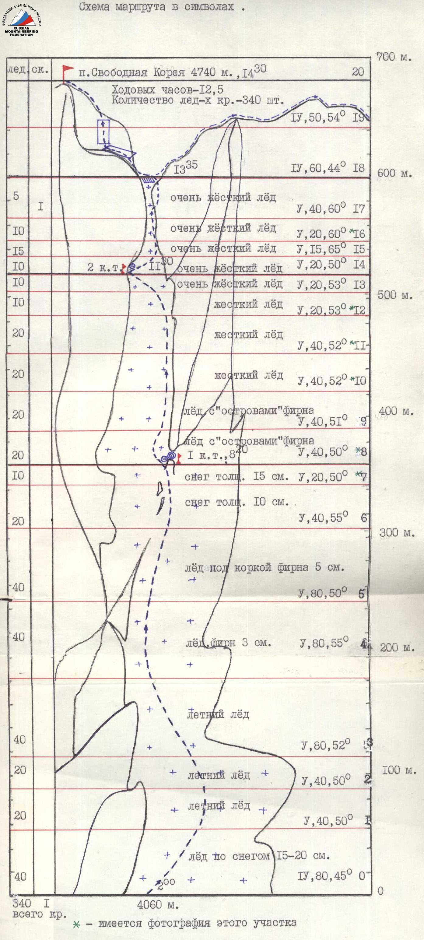
Route Diagram in Symbols
M I: 2000
Technical Photography of the Route
— Barber's route. - Artamonov's route. 6 — locations of photography on the route.