
1.9 Peak Ratseka via the Northwest Ridge, 2B
Name in the classifier: "via the NW ridge"
Hardware requirements:
- Crampons
- Set of stoppers
- Rock pitons
- 4-6 quickdraws
- 14-16 carabiners
- 3-4 slings
Maximum height: 3930 m
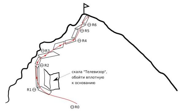
Fig. 1.8: Route to Peak Ratseka via the Northwest Ridge (2B)
From the Light house hut, ascend almost to the top of the "Crocodile" moraine, landmark - the characteristic flat area of rock "Televizor" on the left.
Section R0-R1, length 200 m, cat. I: Traverse the slope under it to the loop in the rock 7. Continue 10 m further, in a pronounced couloir, the technical part of the route begins.
⁷ Loop coordinates: height 3790 m, coordinates 42.324418, 74.538945 ⁸ Light house: coordinates 42.533471, 74.531492 ⁹ "Crocodile" moraine: coordinates 42.524032, 74.536849 ¹⁰ "Televizor" rock: coordinates 42.524021, 74.538311
Section R1-R2, length 80 m, cat. II, cat. III.
- First rope - move up the couloir. Rocks may fall from it, so it's better to belay from the loop.
- From the second belay station ₂в, pass the next inner corner on the right side, to the inclined ledge. Placement of protection may not be possible everywhere.
¹ Second belay station: height 3835 m, coordinates 42.523825, 74.539246
² Inclined ledge: height 3862 m, coordinates 42.523540, 74.539348
Section R2-R3, length 50 m, cat. II: "Sheep's foreheads" on the right side of the ridge, to the fourth belay station ³. In summer, it's passable without problems, in winter it may be more challenging.
The first 10 meters have little relief for belaying, cracks are narrow.
³ Fourth belay station:
- height 3888 m
- coordinates 42.523316, 74.539556
Section R3-R4, length 80 m, up to cat. III: Bypass the ridge "gendarme" on inclined ledges, length 40 m, cat. II, followed by 10 m, cat. III, inner corner to the ridge. Here is the intermediate belay station 4в. Move along the ridge, length 30 m, cat. II. Belay through the relief. 4th intermediate belay station: height 3900 m, coordinates 42.523018, 74.539486
Section R4-R5, length 50 m, cat. III: From the sixth belay station 5в, inner corner, many cracks. Belay: stoppers. 5th intermediate belay station: height 3920 m, coordinates 42.522695, 74.539586
Section R5 - summit, length 40 m, cat. II: move along a simple ridge with scree to Peak Ratseka. ⁶ Peak Ratseka: height 3930 m, coordinates 42.522455, 74.538805
Descent from the summit to the other side, via route 2A
Comments
Sign in to leave a comment