
- Ascent category — snow and ice
- Kyrgyz Ala-Too
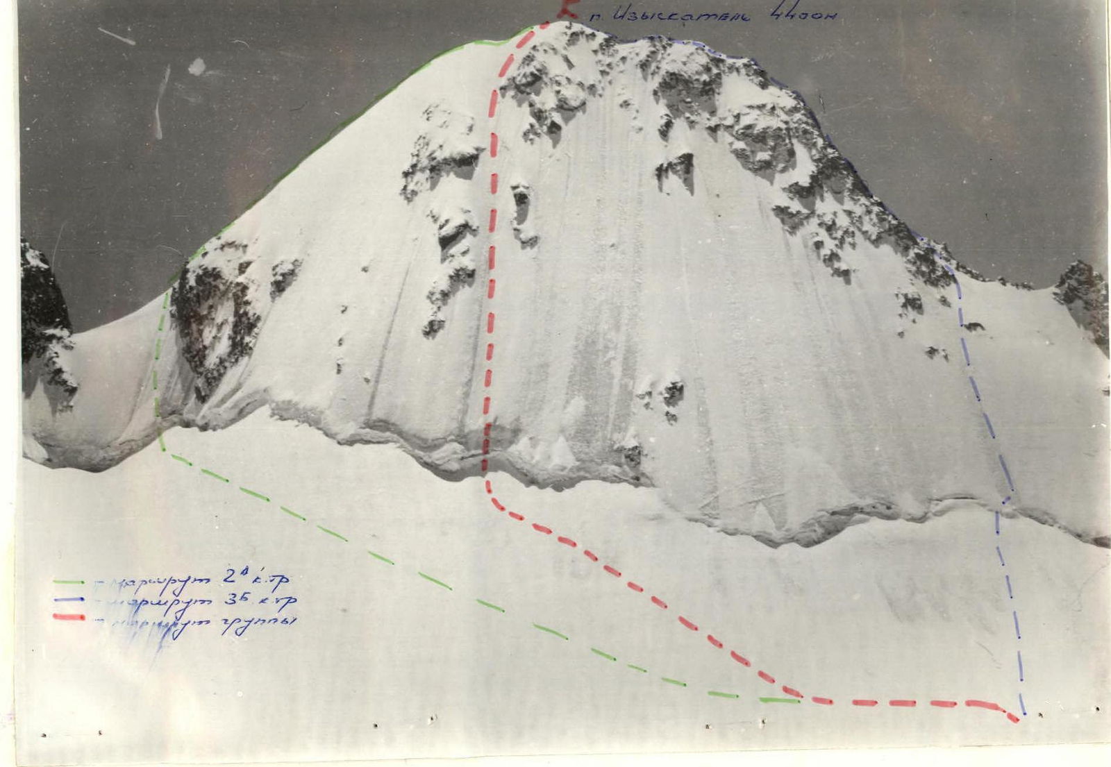
- Peak Izyskatel (4400 m) via the center of the northwest face
- Proposed category difficulty — 3B
- Height difference — 300 m Route length — 400 m. Average steepness — 50°
- Pitons driven — 31/0 (ice screws)
- Climbing hours — 4.5
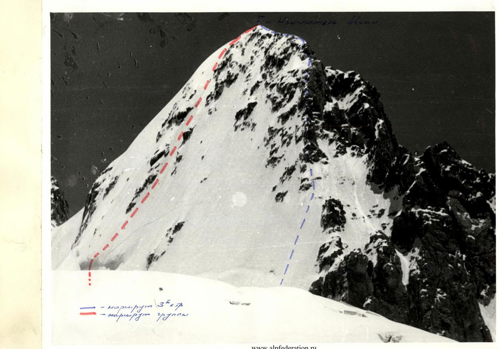
- Base camp — hut near Koronsky glacier
- Rodikov A.P. — Candidate Master of Sports Rozhkov A.N. — Candidate Master of Sports
- Date of departure on the route — January 13, 1988
Date of return — January 13, 1988
II. KSP of Kyrgyz Ala-Too

Route Description
Approach from AUSB «Ala-Archa» to Ratsek hut along a trail (3 hours).
Further:
- Along the right-bank (orographic) moraine of Ak-Sai glacier
- Along a trail bypassing the icefall
- Exit to the upper stage of the glacier
- Further approach to the hut near Koronsky glacier (1.5–2 hours from Ratsek hut).
Night's stay.
From the hut:
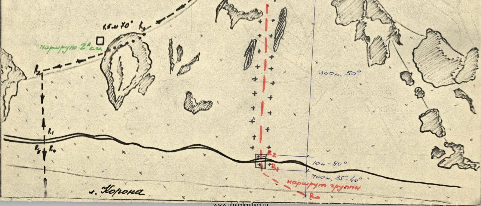
- Exit to the plateau via the right-bank scree of Koronsky glacier
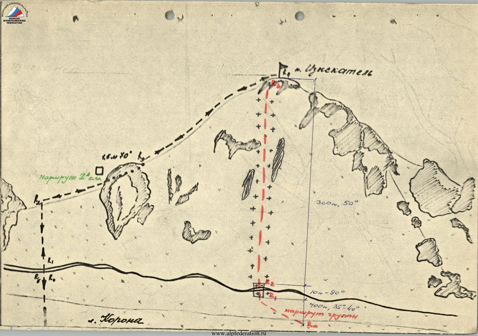
- Turn right here and cross the glacier in the direction of Peak Izyskatel (1.5 hours)
- Approach the center of the northwest face of the peak.
100 m ascent along a snowy slope with increasing steepness up to 35–40° to the bergschrund. The 8–10 m high bergschrund is overcome with the help of an ice axe. Belay via ice screws. Further, straight up between rock islands — exit to the summit. The ice is hard, steepness is 50°, belay via ice screws — 300 m.
From the start of the route to the summit — 4.5 hours. The route is steeper and longer than the 3A category route to Peak Teke-Tor from the north, and can serve as good training for groups attempting ice routes on the north faces of Ak-Toо, Baylyan-Bashi, and Svobodnaya Korея.
 www.alp-federation.ru ↗
 pahona «AKSAY»
0.1 16,10° L
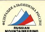
Ascent Route to Peak Izyskatel
3B category difficulty.
Introduction
In the summer of 1967, the Moscow City Council of the SDSO "Burevestnik" organized a complex high-altitude expedition. Before the main ascents, Moscow climbers were sent to gather at the Ala-Archa alpine camp. There, they underwent:
- snow,
- rock,
- ice training
and initial acclimatization. Several training ascents were made during this time. One of the ascents was made to Peak Izyskatel.
It is located in one of the spurs extending from the 5th tower of Koron, and divides the Ak-Sai glacier in its upper part into two halves. The height of the peak is about 4400 m. It occupies an almost central position in the middle of the Aksai glacier, and can be used as a panoramic point for viewing the Aksai horseshoe and Koron.
Consultation on Peak Izyskatel was given by instructors from the Ala-Archa alpine camp. The description available in the camp was also used. After the ascent, a debriefing was held, where it was recommended to assign the 3B category difficulty to the route.
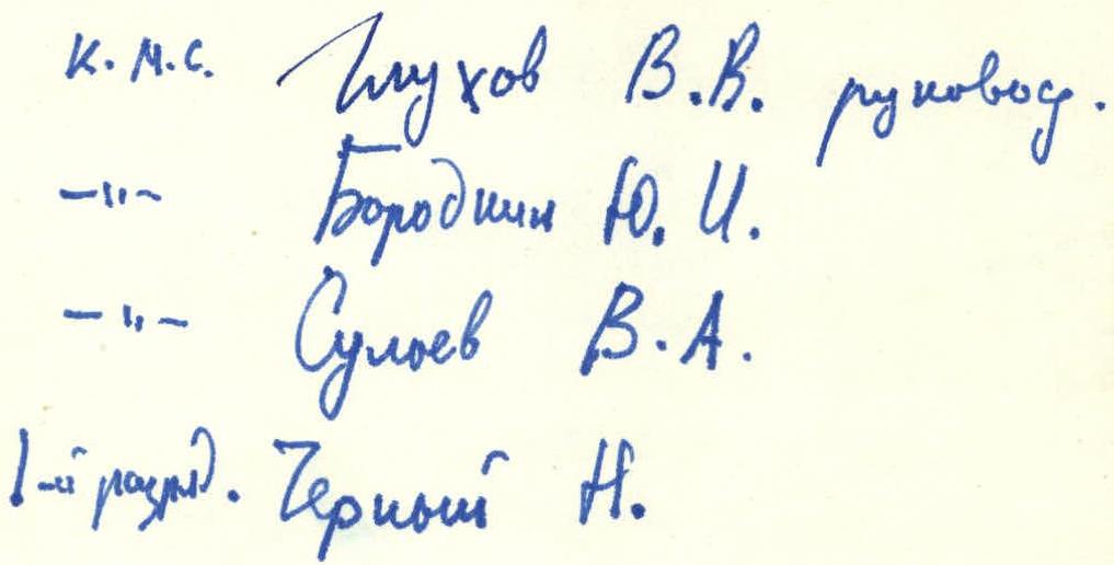
Candidate Master of Sports Glukhov V.V. (leader)
Borodin Yu.I.
Suliev V.A.
1st category Chernyshov N.
Ascent Details
I. Description of the Ascent to Peak Izyskatel
June 30, 1967
Preparation for the ascent began at the Ala-Archa alpine camp. This was the first ascent of the season. We passed the second medical check. After lunch, we departed at 14:00. We arrived at Ratsek hut in 3.5 hours. The weather was unstable, with snow falling at times. Night's stay.
July 1, 1967
Rise at 7:15. The weather did not improve. We departed at 9:00. We crossed the moraine and exited onto the lower, calm part of the Aksai glacier. We approached almost under the icefall and sharply turned left onto the right orographic moraines. Here, we found a trail and further along the steep moraine, we exited above the icefall. Further — again on the glacier until it turned towards the Koron massif. Night's stay near the meteorological platform.
The weather cleared up, with a good view of the Aksai horseshoe. The journey took about 4 hours. We gained a height of about 1 km, which is sufficient for the first day of ascent.
We set up the tent, prepared lunch, ate, and for acclimatization, we went for a walk on the nearest slope, gaining a height of 200 m, and trod paths in the deep snow for the next day. After the bad weather, there was a lot of snow.
July 2, 1967
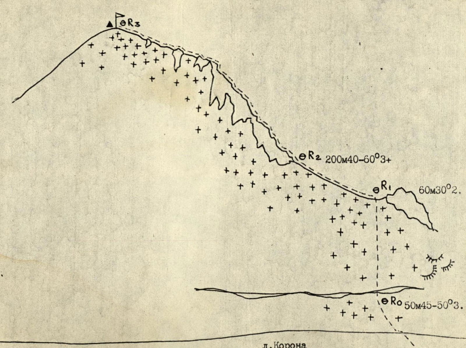
Rise at 7:00. Breakfast was prepared the night before, and it only needed to be heated. Departure in 1 hour. We followed our previous tracks, which had been slightly covered by snow overnight. Further — a second ascent of 100 m. We bypassed a crevasse and exited onto the plateau before Peak Izyskatel (photo 1).
The route was clear before us, everything was straightforward, and only adjustments for snow were needed. A lot of snow had fallen during the bad weather. On the plateau, our legs sank above the knee. We had to change the lead frequently. There was especially a lot of snow before the peak, where it had drifted above the waist, and we had to dig a trench for 3 ropes. We started the ascent under a rock island, as we were afraid of an avalanche elsewhere. With such a large amount of snow, the bergschrund was not an obstacle. From the bergschrund to the rock island — 6 ropes, belay via ice axe. Each team worked independently. The steepness of the snowy slope was up to 40°. We exited onto the rock island and after 2 ropes, we were on the saddle. From the saddle, we turned left into the right couloir from the ridge, with a turn in the upper part of the couloir into a gap on the ridge. An ice screw was driven into the rocks, as there was ice in the couloir, and the length of the couloir was 1 rope. Then — along the ridge. The rocks were of average difficulty but were completely icy and snow-covered, so piton belay was necessary. We regularly drove pitons, but sometimes had to chip away ice or clear rocks from snow with mittens.
The wall in the middle of the ridge was particularly interesting — 1 rope. This was the key section. Smoothed slabs with a small number of holds, 6 pitons were driven on this section. Some of them were left, as it was decided to descend via the ascent route due to the snowy conditions.
In total, 15 pitons were driven, and 9 of them were left for the descent.
At 11:15 — on the summit. This peak is central in the area. The entire panorama of the Aksai horseshoe can be seen. The routes to:
- the 6th tower of Koron
- Svobodnaya Korea
are especially visible.
After 45 minutes — descent. 12 pitches and we were on the saddle. Descent on snow in three steps, facing the slope. Further — along our tracks back to the tents.
From bergschrund to bergschrund, the ascent took 6 hours.
Comments
Sign in to leave a comment