I. Ice and snow class
- Central Tian-Shan, Inylchek ridge
- Peak "5581" (Dobroĭ voli) via the direttissima of the North face
- Proposed category of difficulty: 6B, first ascent
- Height difference: 1500 m, main section length: 1900 m, sections with 5-6 category of difficulty: 1250 m, average steepness of the main section: 60.5° (4000-5500 m), out of which 6 category of difficulty: 450 m, 75° (4250-4750 m)
- Pitons used:
| Rock | Bolt | Nuts | Ice |
|---|---|---|---|
| 12 | 0 | 0 | 314 |
- Climbing hours — 27, days — 3
- Overnight stops: on an artificially created ice platform; 2nd stop on a platform carved on a snow-ice ridge.
- Team leader: Alperin Vladimir Maevich, Master of Sports of the USSR Team members:
- Erokhin Oleg Valerievich, Master of Sports of the USSR
- Kharaldin Alekseĭ Viktorovich, Candidate Master of Sports
- Zhilin Alekseĭ Yurievich, Candidate Master of Sports
- I.O.
- Coach: Gorbenko Mstislav Mstislavovich, Master of Sports of the USSR, International Class
- Departure to the route on July 18, 1989. Reached the summit on July 20, 1989. Returned on July 21, 1989.
- Organization: Odessa mountaineering club
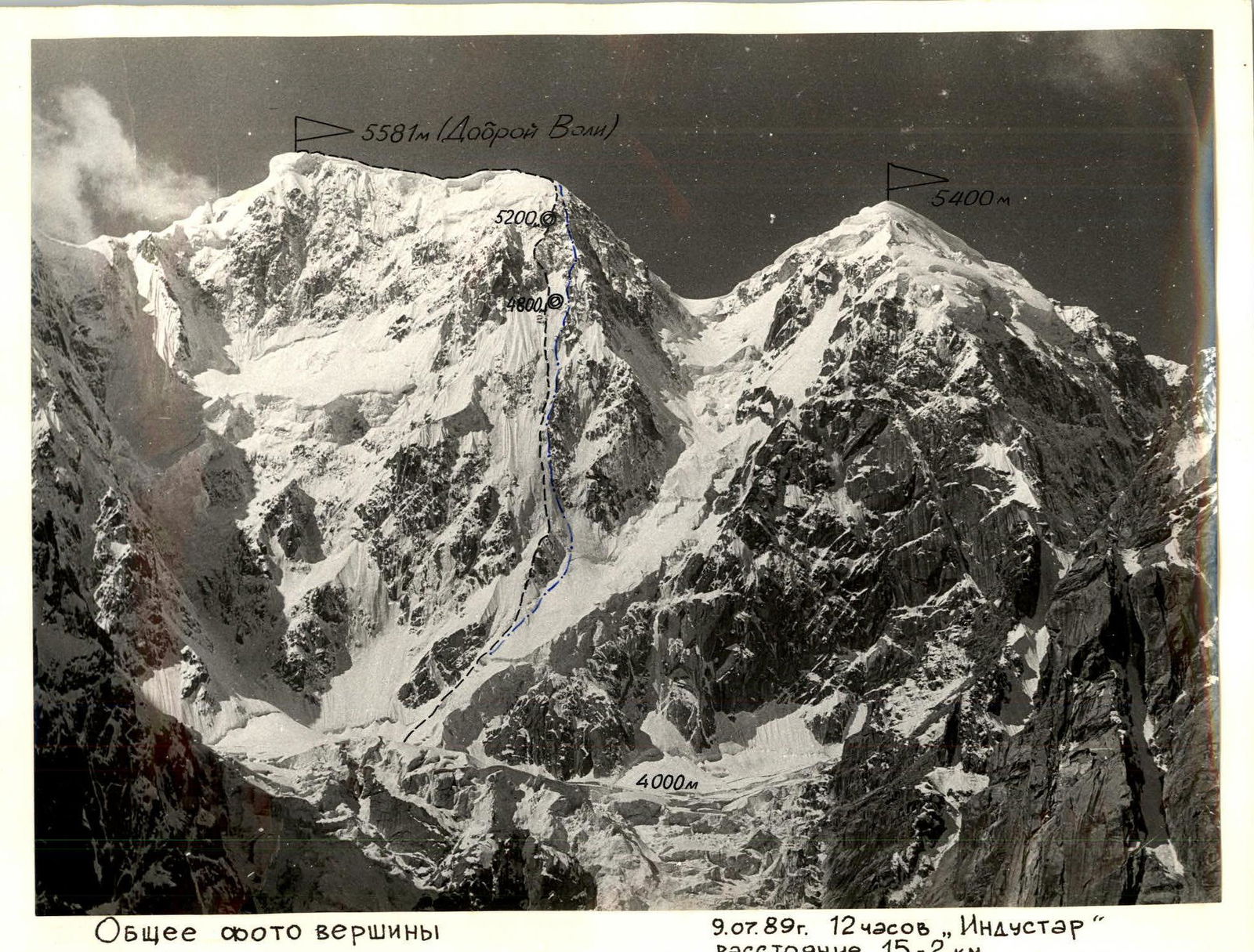
General photo of the summit
Route of the Odessa mountaineering club team
Route of the Ukraine team July 9, 1989, 12:00 — "Industar" — distance 1.5-2 km, helicopter shot. Height ≈ 4200 m.
- Route of the Odessa mountaineering club team —
- Route of the Ukraine team —
Tactical actions of the team
The team followed the route in full accordance with the tactical plan and schedule. Night stops were organized at planned locations. The movement of the rope teams on the route was autonomous. The second rope team used pitons left by the first team. At several sections of the route, fixed ropes were set up:
- Section R7-R8 — 40 m — complex, heavily snowed rocks with flow ice (photo II).
- Section R8-R9 — 40 m — icy rocks in a chimney when bypassing the 1st "gendarme" on the left.
- 80 m — deep, loose snow on steep ice.
Actual change of lead climbers by days and route sections
| July 18, 1989 | R2-R3 | Erokhin |
|---|---|---|
| R3-R4 | Kharaldin | |
| R4-R5 | Zhilin | |
| R5-R6 | Alperin | |
| July 19, 1989 | R6-R7 | Erokhin, Kharaldin |
| R7-R8 | Zhilin | |
| R8-R9 | Zhilin, Kharaldin | |
| July 20, 1989 | R9-R10 | Erokhin, Alperin |
| R10-R11 | Alperin, Zhilin, Erokhin, Kharaldin |
For climbing and belaying, the team used:
- Double 10 mm rope of domestic production
- Ice screws
- Quickdraws with "Irbis-2200" carabiners
- Ice axes: "LES", "Shakal", and "Charles Moser" with a firn shovel
- Crampons "Salewa", foot fangs (photo I-7)
The team did not use belay devices (like " шайба", " восьмёрка" ) for leader belaying, used domestic rope (without UIAA marking), and the leader did not use a shock absorber, as the ice terrain allowed for safe piton spacing (photo 5).
At belay stations, at least 3 pitons were blocked; in addition, each climber had their own self-belay piton.
Most of the route was climbed autonomously by the rope teams, changing places in the middle of the day. The lead climber in each rope team changed:
- every few hours,
- in the upper part of the route — every 50-100 m.
Rest:
- On the first day, no rest was planned, but a forced rest occurred from 14:00 to 16:00.
- At the bivouac — from 21:00 to 6:00.
- Departure on the second day at 8:30, short rest at 7:00.
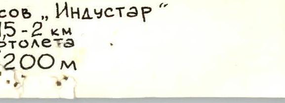
Profile of the lower and upper parts of the route Route of the Odessa mountaineering club team July 9, 1989, 12:00. "Industar" lens, helicopter shot. Height ≈ 5000 m, distance ≈ 500 m.
From 13:00 to 14:00, climbing until 18:00. Rest at the bivouac from 21:00 to 6:00. Departure on the third day at 8:30, forced rest (lack of visibility) for about an hour from 14:00, reached the summit at 15:00. The team's nutrition was organized as follows: in the morning — sausage, cheese, crackers, tea, sugar, candies. During the working day and during stops — "pocket" food, drinking from flasks. In the evening at the bivouac — broth, lard, sausage, crackers, tea, honey, nuts.
Night stops were organized in safe locations: the first under the protection of a rock island, the second on a ridge of a counterfort (photo 12-14), belayed on rock and ice pitons with a rope passed through the tent. There were no falls or injuries during the ascent.
Passing steep ice on the route was not a problem for the team (photo 1, 6, 7). Team members, during training and competitions in ice technique, had climbed vertical and overhanging ice walls. However, on ice routes, one often encounters refrozen ice with voids, layered, where ice axes, ice hooks, crampons, and pitons do not hold well (photo 4). This increases the difficulty of the ascent. It is necessary to repeatedly hammer in the pick of the ice axe, clean the spot for the ice screw, and reduce the distance between pitons. In the 1988 and 1989 championships, the team used ice screws with a two-start thread, rigidly fixed handle for increased speed and convenience of screwing, which worked well both on soft glacier ice and during the ascent (photo 3, 5). Except for the steepest sections, the lead climber worked with an ice hammer and ice hooks from the waist.
During snowfall and small powder avalanches, movement along the route did not stop, but it was necessary to constantly monitor the upper slopes and warn the lead climber about avalanches.
The team maintained constant radio contact 4 times a day with the base camp, where observers were located. A rescue team was stationed at the base camp and, upon the team's exit to the summit dome, part of it (4 people) moved to the Komosomolsky glacier to meet the descending team. On the fourth day, the team descended from under the summit along the O.V. ridge into the southern cirque of peak 5581 m, from there to the upper reaches of the Komosomolsky glacier, and then to the Inylchek glacier, and with the onset of darkness — to the base camp, indicating sufficient reserves of strength among the participants.
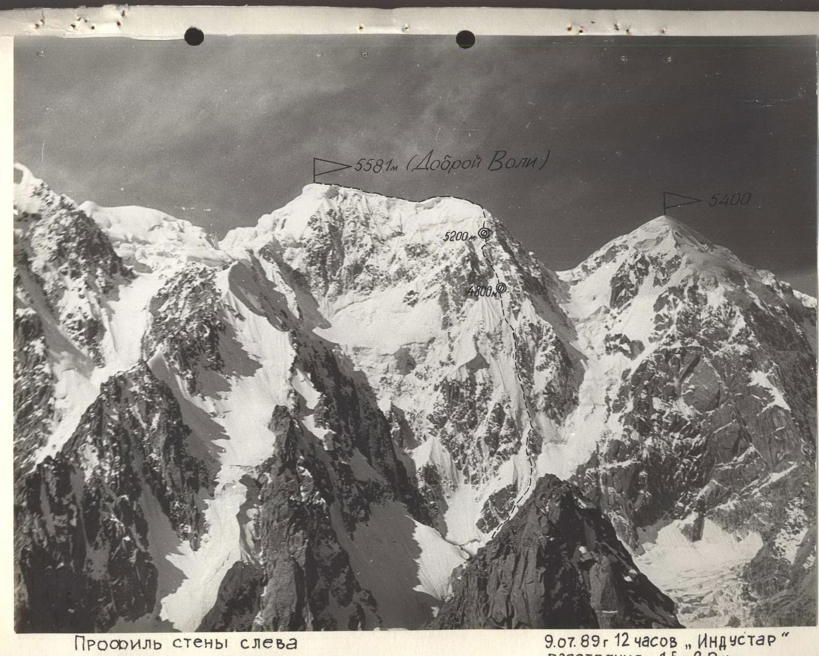
Profile of the wall on the left
Route of the Odessa mountaineering club team:
- July 9, 1989, 12:00 — "Industar"
Distance — 1.5-2.0 km
| Cr. kr. sk./led. | Section | SCHEME IN UIAA SYMBOLS | Cat. diff. | Length in m | Steepness in degrees |
|---|---|---|---|---|---|
| R1 | 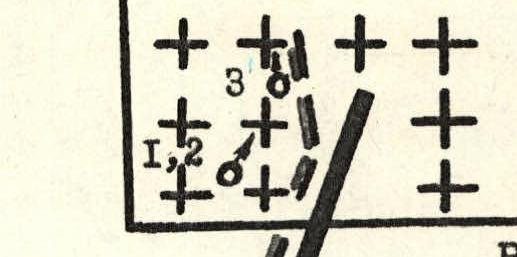 | VI+ | 150 | 80 | |
| ++++ ++++++ ++++ ++++ | |||||
| ++++ ++++ ++++ | |||||
| R2 | 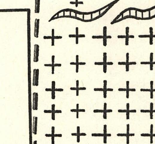 | IV | 300 | 45 | |
| ++++ ++++ ++++ ++++ ++++ | |||||
| ++++ ++++ ++++ ++++ ++++ | |||||
| ++++ ++++ ++++ ++++ ++++ | IV- | 100 | 40 | ||
| 4:00 July 18, 1989 R0 |
 www.alpfe↗
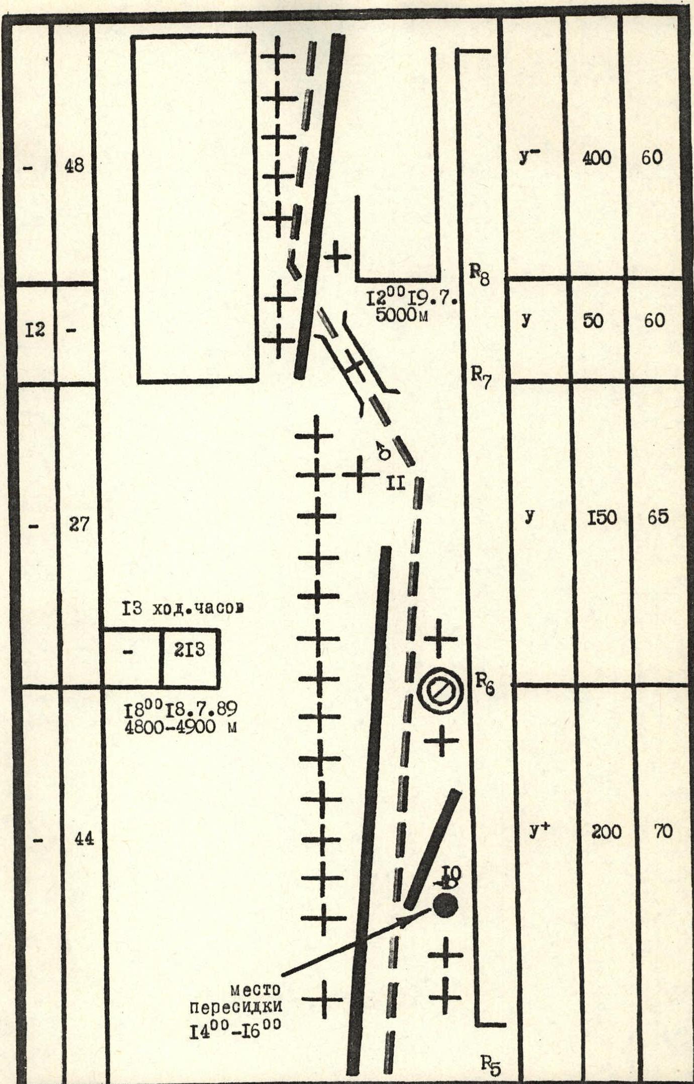 www.alpfederation.nig-5↗
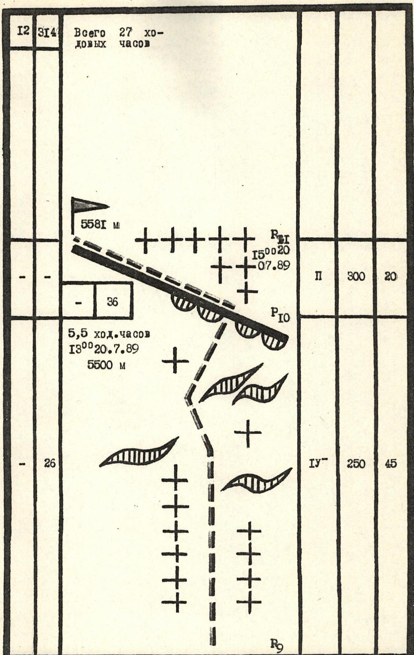 The approach to the route across the plateau in rope teams (crevasses!, possible falling ice from the icefall) takes about 1 hour. Entry from the bivouac at 3:00 with headlamps. After bypassing the icefall, we climb straight up to the bergschrund. The Ukraine team enters behind us with a 1-hour interval. Section R0-R1. We pass a steep snowy slope on the approach to the bergschrund, the snow is dense, steps form well. Belay via ice axe and serac overhangs. R1-R2. We cross the bergschrund in its least broken part, overcoming a 1.5 m ice wall. Upwards — a firn slope, which becomes steeper and gradually turns into ice. We start using ice screws for belaying. The ice is layered, refrozen, and it takes a long time to clean the spot for screwing in the piton. R2-R3. After bypassing the second rock1 island on the left, the steepness of the ice slope sharply increases (up to 80°). We use ice hooks with leg harnesses; the Erokhin-Kharaldin rope team is ahead. The rope teams work autonomously, but the second team uses and screws in pitons left by the first. Belay on a double 10 mm rope. The ice is flowed, refrozen, layered, and often ice lenses are chipped out from under crampons, ice hooks, and pitons. We work alternately, with careful belaying. At the belay station, we block 3 pitons. R3-R4. The steepness of the wall decreases somewhat, the structure of the ice. After the wall is lit by the sun, small powdery snow avalanches start to fall, which, without causing any harm, greatly slow down progress, make photography difficult, and force us to constantly monitor the upper part of the slope. R4-R6. When approaching the rock island "Parabel lum", the steepness increases, the rocks of the island are icy, steep, the ice layer is insufficient for organizing belaying, so we continue moving along the ice to the right of the island's rocks. We change lead climbers, with the Zhilin-Alperin rope team going first. After 13:00, ice fragments start falling with the avalanches. We had to move to the right under the protection of an ice ridge and stop climbing. The weather worsens, it becomes cloudy, and by 16:00 the "bombardment" stops, and we continue moving upwards since there is no suitable place for a bivouac. After two hours of work, we approach the 2nd rock island and, under its cover, carve out a step in the ice for a bivouac. R6-R7. At 8:30, the Kharaldin-Erokhin rope team departs. The slope's steepness gradually decreases, a layer of snow appears on the ice, which becomes thicker. When approaching the rock belt, the snow is knee-deep and loose. To organize belaying, we have to dig pits down to the ice. R7-R8. We change rope teams. Zhilin passes 50 m of icy rocks with piton belay and reaches a steep snow-ice ridge of the counterfort. We leave a fixed rope for the second rope team. R8-R9. The weather worsens, it starts snowing, visibility is up to 20 m. At a slight flattening, we gather, take a short rest, and have a snack — about an hour. The snowfall continues, and avalanches start to fall, but visibility improves to 100 m. We continue moving along the ridge towards the 1st black "gendarme" in the hope of organizing a bivouac under it and processing the further path, but the ice steepness under it is at least 50°, and there is no platform. We bypass the "gendarme" on the left along the inner corner with flow ice, set up fixed ropes, and after passing another 2 ropes, we reach a small snowy ridge. Having cut out 2.5-3 m of the ridge, we cleared a slab and organized belaying through it, set up a bivouac. Departure in the morning at 8:30, very cold. Ahead, as usual in the morning, are Erokhin and Kharaldin. The snow layer becomes thicker, the steepness decreases; bypassing the 2nd black "gendarme" on the left, we reach the Dome. We use firn pitons, belay via ice axe, and also, by digging snow, ice screws. R9-R10. The Alperin-Zhilin rope team goes first. Through deep snow, sometimes sinking up to the waist, bypassing cracks and crevices, we move in the direction of the smallest cornice on the summit ridge. The weather worsens, visibility decreases to 20-40 m. Belay on 2 ice axes stuck in the snow. Having cleared a small cornice, we reach the ridge. Along a wide, gentle ridge, making a trench in the snow, we approach under the summit ascent, which is separated from the ridge by a break in the ice slope. There is no visibility! We gather together, discuss further actions. Around 15:00, breaks appear, we see a passage, and quickly passing the break and snowy dome, we reach the summit of peak 5581 m at 15:03. Snowfall begins, and, descending 100-150 m along the snowy ridge to the south, we stop for a bivouac. A characteristic feature of the route is the absence of flattenings, platforms, places for rest and bivouac, heavy snow cover, direct, avalanching, without relief and crevices rock. The ascent was climbed with more than half of the climbing hours under the influence of factors of the 2nd degree of weather conditions and terrain state, namely:
- refrozen, flow ice — section R2-R3;
- "snowfall" — constant fall of powdery snow avalanches — section R3-R5;
- snowfall, sometimes visibility 10-40 m — section R8-R9;
- deep snow above the knee, sometimes above the waist — section R9-R10. Each morning — frost.
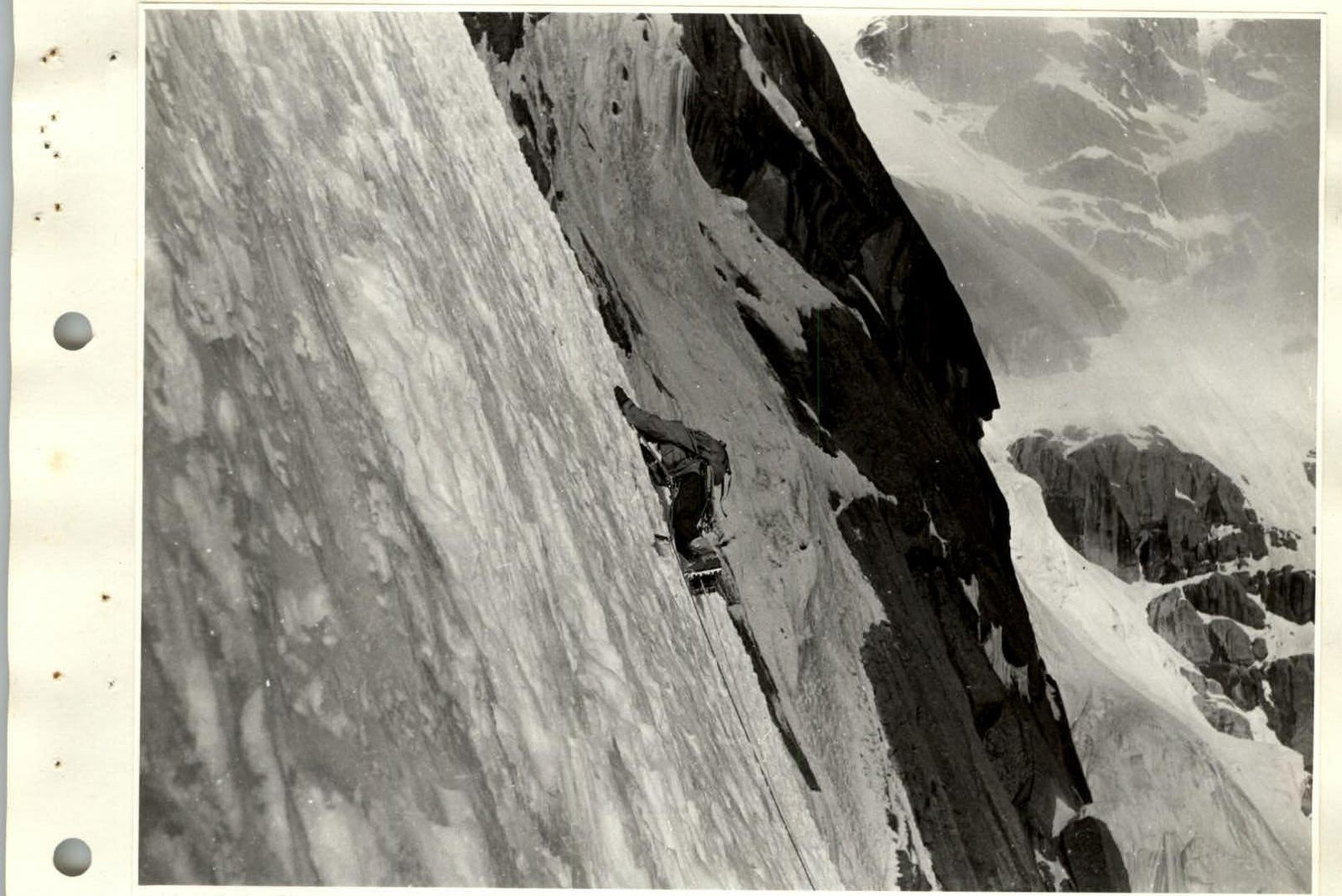
Photo #1. Section R2-R3. July 18, 1989, 9:00.
Photo #8. Section R3-R4. July 18, 1989, 11:00.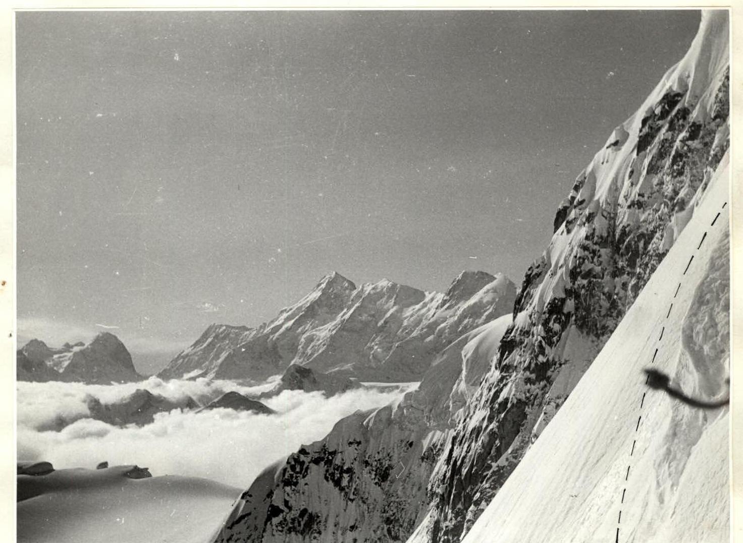
Photo #10. Section R5. July 18, 1989, 14:00. Peaks Pobeda, V. Pshavely, Neru from the place of respite during the icefall.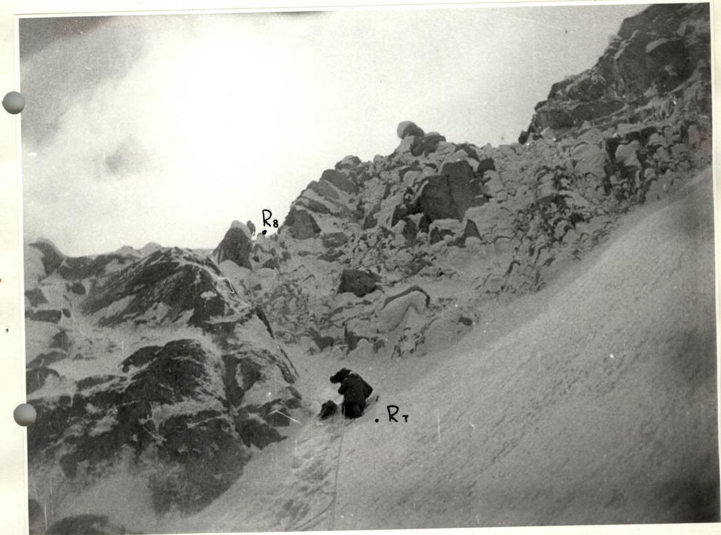
Photo #11. Section R7-R8. July 19, 1989, 12:00.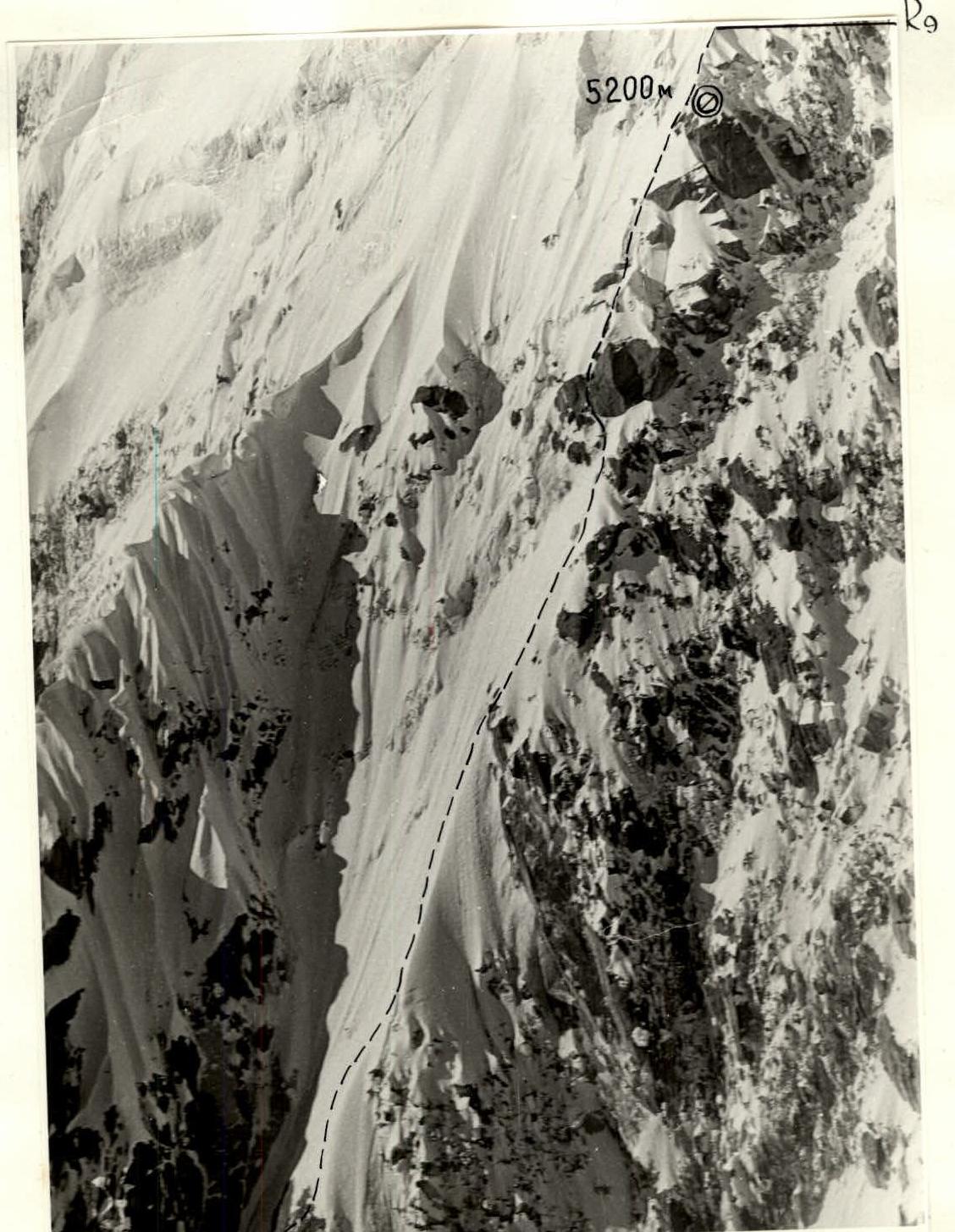
Photo #15. Section R8-R9. July 21, 1989, 12:00. Helicopter shot. Height 5000 m, distance 150 m.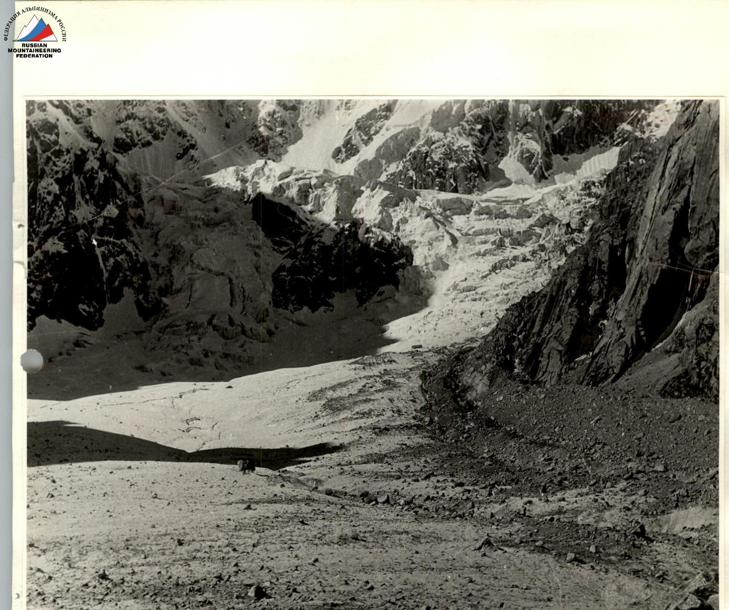 Photo #17. July 21, 1989, 12:30.
Photo #18. Section R7-R9. July 21, 1989, 12:00.
Helicopter shot, height — 5000 m, distance — 400 m.