
7.2. 231
Ascent Registration Form
Ascent category Ascent area Summit Estimated difficulty category Route characteristics Travel time Leader's full name Team coach ОСО Date of departure Organization
- rock
- Tian Shan, Trans-Ili Alatau
- Shkolnik 3850 m via North-East ridge
- 1B category
- elevation gain 550 m
- slope 35°
- 6–7 hours
- Ukhov A.I. and Novikov V.I. 1st rank
- Chumakov V.D.
- July 20, 1985
- KSP of Trans-Ili district
Route description to peak Shkolnik via North-East ridge (3900 m) — 1B category
Peak Shkolnik is located in the basin of the Malaia A-Atinka river. It is situated in the North ridge branching off from peak Abai, approximately 1.5 km to the north. To the south of peak Shkolnik, there is Abai pass (3650 m) in the ridge; to the north, there is Talgarsky pass (3200 m) in the same ridge. Strictly to the east of peak Shkolnik rises peak Fizkulturnik (4000 m).
The route to peak Shkolnik runs along the north-eastern ridge starting to the right of the terminal moraine of the Bogdanovich glacier and stretching for about 800 m. The ridge leads directly to the summit. The approach to the route is possible:
- through Talgarsky pass;
- through Abai pass.
In winter conditions, when there is a risk of snow avalanches from the slopes of peak Abai, the first option is preferable.
The approach through Talgarsky pass starts from the lower station of the chairlift at the Chimbulak ski resort. Reaching the pass takes 2–3 hours. From the pass, follow the moraine of the Bogdanovich glacier towards the glacier tongue along a well-marked trail (takes 1–2 hours).
The approach through Abai pass starts from the Turk-Su hydro-post, upwards along the "Chertovo" gorge. The exit to the pass is from the tongue of the Abai glacier. From the camp to the pass takes 2–3 hours. From the pass, descend along the tongue of the Bogdanovich glacier to the start of the route (30 min – 1 hour).
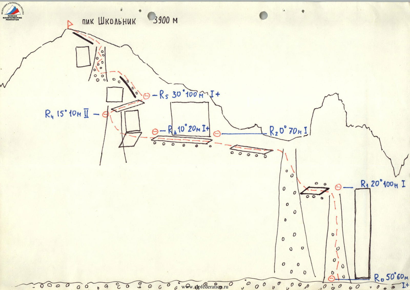
The start of the route is not at the end of the north-eastern ridge but 300 m to the south, closer to the summit on the south-eastern side of the ridge. A characteristic landmark to reach the start of the route is a pillar-like tower-gendarme in the ridge, after which there is a depression-saddle closer to the summit. Further towards the summit, the ridge does not have significant gendarmes.
From the tower-gendarme, two couloirs descend downwards; the right one is bounded by a rock wall with a southern direction (a good landmark). The route starts in this couloir.
The couloir contains many ledges with small walls. Easy climbing. Move simultaneously. The couloir leads to a saddle in the ridge. Beyond it, Talgarsky pass comes into view.
From the saddle, proceed upwards along the ridge towards the summit, always keeping to the left side. Small ledges bypassing rock sections lead into a couloir — the key section of the route.
The couloir is about 20 m long and ends with a vertical section intersected by a rock ledge from left to right diagonally (about 10 m). Here, it is advisable to secure with "perils".
Further, the route goes up almost straight through small couloirs with scree and rock outcrops, leading to the summit. The summit is a large sloping area. A cairn is built in the upper part and is clearly visible. Descent from the summit follows the ascent route.
R4 15° 10 m II–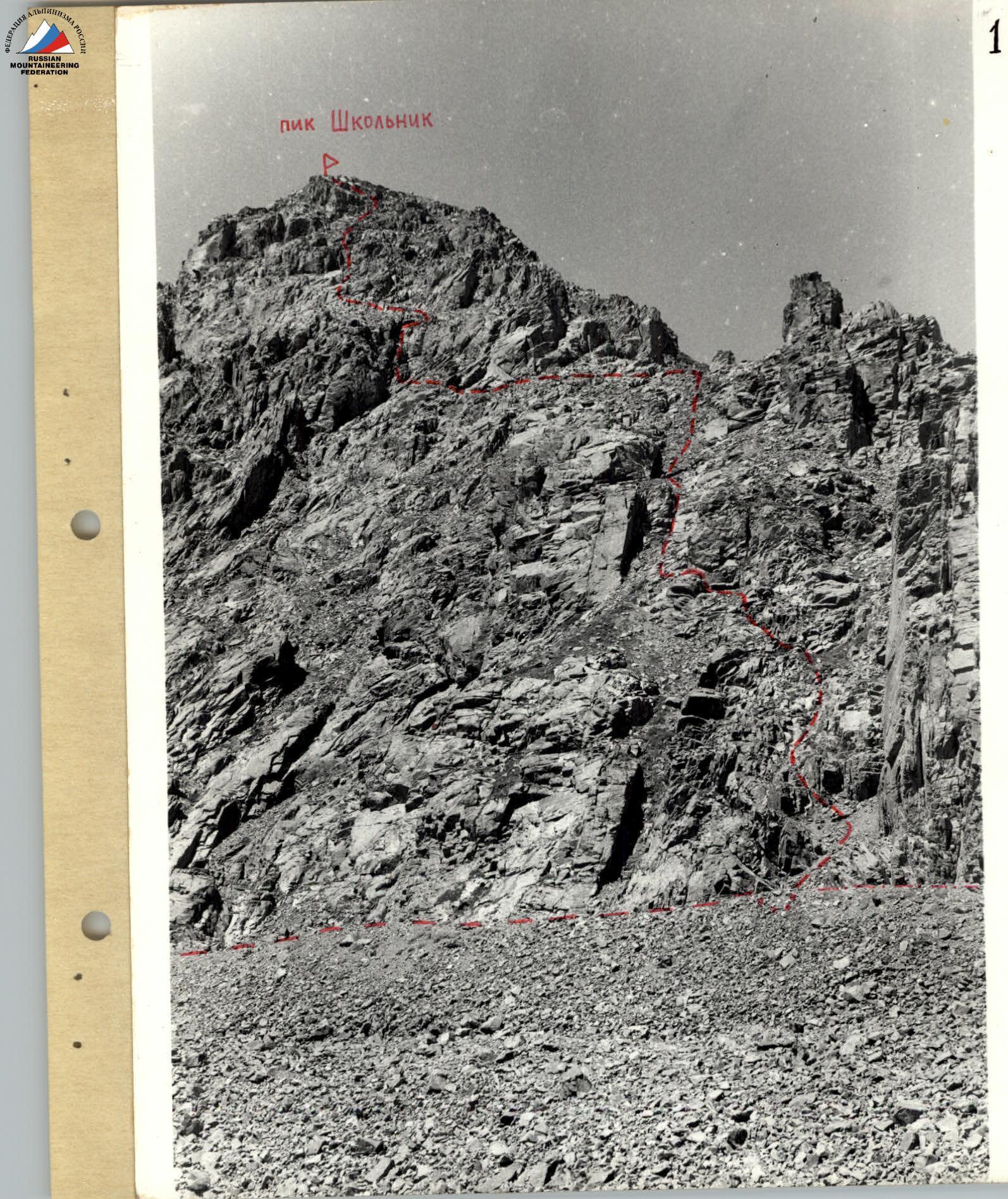 Chimbulak 3400 m
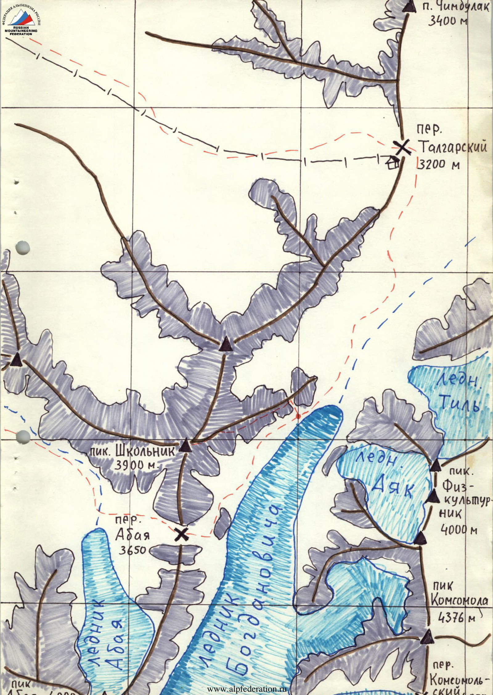
Comments
Sign in to leave a comment