
ASCENT PASSPORT
- ASCENT CLASS — snow and ice.
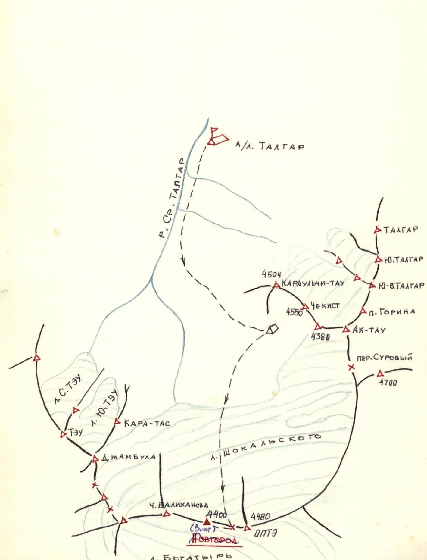
- ASCENT AREA — Tian-Shan, the peak is located in the main ridge of Zailiyskiy Alatau between the peaks OPTЭ and Chokan Valikhanov. To the south of the peak is the Bogatyr glacier, to the north is the Shoskalsky glacier.
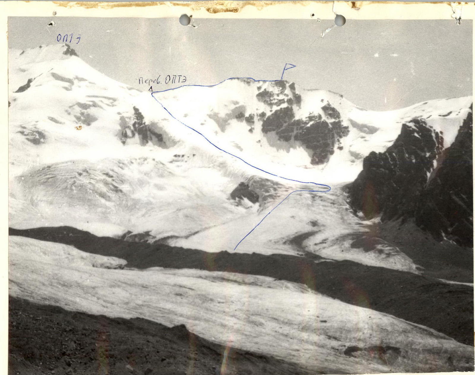
- PEAK ELEVATION — 4400 m. The route runs from the north along the Shoskalsky glacier to the OPTЭ pass, from the pass along the eastern ridge to the peak.
- PROPOSED DIFFICULTY CATEGORY — 2A.
- ROUTE CHARACTERISTICS — elevation difference: from the base of the Shoskalsky glacier to the OPTЭ pass 450 m, from the OPTЭ pass to the peak 200 m. Difficulty of individual sections — from 1B to 3A cat. diff. Average steepness of the route 25°.
- PITONS USED — 4 ice screws for belay purposes.
- NUMBER OF TRAVEL HOURS — from the camps under the Chekist peak (“Football field”) to the OPTЭ pass 4 hours, from the OPTЭ pass to the peak 1 hour, descent from the peak to the camps 2 hours.
- NO OVERNIGHT STAYS are planned on the route.
- PARTICIPANT INFORMATION — team leader Lobushkin Vladimir Nikolaevich, 1st sports category, Popov Alexander Mikhailovich, 1st sports category, Kolonogorov Alexander Valerianovich, 2nd sports category, Petrov Mikhail Nikolaevich, 2nd sports category, Prekhin Viktor Grigorievich, 2nd sports category.
- TEAM COACH — Karasev Alexander Vasilievich, Master of Sports, category I instructor.
- DATE OF DEPARTURE AND RETURN — July 18, 1984.
 www.alpfederation.ru ↗
ASCENT AREA MAP FOR NOVGOROD PEAK
DESCRIPTION OF THE ASCENT ROUTE TO NOVGOROD PEAK FROM OPTЭ PASS 2A DIFFICULTY CATEGORY
From the camps under the Chekist peak (“Football field”) cross the central moraine of the Shoskalsky glacier in the direction of Chokan Valikhanov peak, reach the base of the glacier.
Transition across the glacier:
- The first open crevasse is bypassed on the left.
- Traverse right is performed, bypassing the second crevasse on the right.
- Then move up the glacier to the left–up towards the OPTЭ pass (caution: hidden crevasses!).
When reaching the pass, it is necessary to overcome a snow and ice cornice — belay is mandatory.
After reaching the OPTЭ pass, the route follows the eastern ridge of the peak. Up the ridge, two ascents are traversed with subsequent flattening: the first – 25°, 120 m, the second – 30–35°, 250 m, leading to the subpeak. Then along heavily broken rocks to the “saddle”, which is a lowering of the ridge in the form of an ice section with a slope of 45° and a length of 12 m, bounded on the right by a snow cornice and on the left by a vertical rock wall. Descent into the “saddle” is done using a sport method or rappel. After the “saddle”, 200 m movement along the rocky ridge or along snow and ice to the right of the ridge (caution: cornice!) to the peak.
Descent is done via the ascent route. Recommended equipment for a group of 6 people:
- Main rope — 3 × 40 m.
- Crampons — 6 pairs.
- Ice axes — 6 pcs.
- Ice screws — 4–6 pcs.
ASCENT ROUTE DIAGRAM TO NOVGOROD PEAK FROM OPTЭ PASS 2A DIFFICULTY CATEGORY
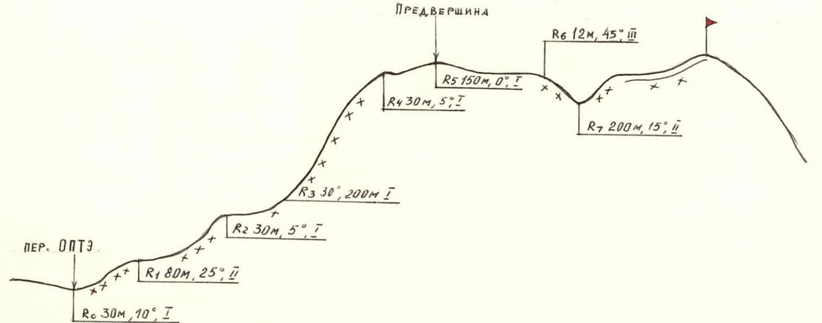
TABLE OF MAIN ROUTE CHARACTERISTICS
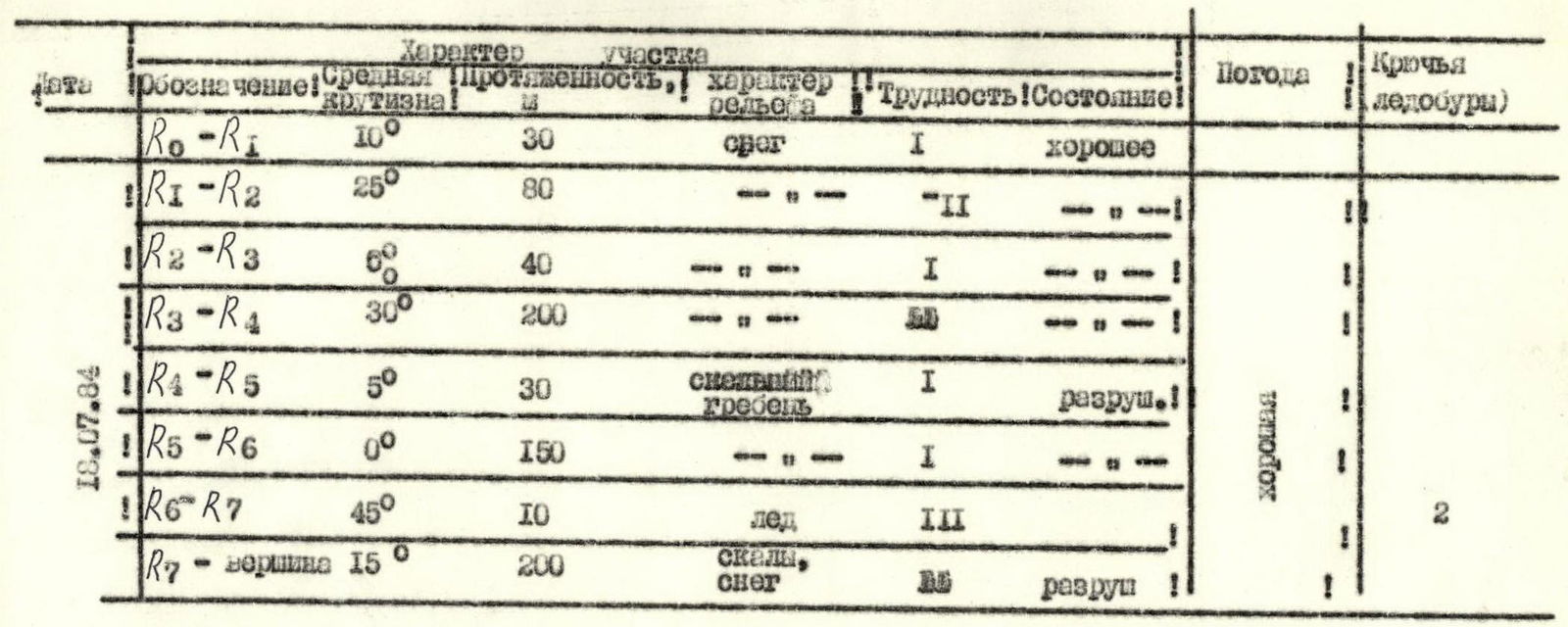
| Date | Designation | Average steepness | Length, m | Terrain characteristics | Difficulty (Condition) | Weather | Pitons (ice screws) |
|---|---|---|---|---|---|---|---|
| 18.07.84 | R0–R1 | 10° | 30 | snow | I (good) | good | |
| R1–R2 | 25° | 80 | rocks, snow | II (good) | good | ||
| R2–R3 | 5° | 40 | rocks, snow | I (good) | good | ||
| R3–R4 | 30° | 200 | rocks, snow | I (good) | good | ||
| R4–R5 | 5° | 30 | snowy ridge | I (damaged) | good | ||
| R5–R6 | 0° | 150 | rocks, snow | I (good) | good | ||
| R6–R7 | 45° | 10 | ice | III (good) | good | 2 | |
| R7–peak | 15° | 200 | rocks, snow | I (damaged) | good |
Comments
Sign in to leave a comment