Brief Description of the Approach to the Route
From the city of Almaty, drive along the highway to the "Leninets" pioneer camp. Then, proceed along the right (orographically) side of the gorge until the confluence of three rivers:
- Levyy Aksay
- Sredniy Aksay
- Pravyy Aksay
It takes 4 hours from the pioneer camp.
The further path lies along the valley of the Sredniy Aksay River, on the right (orographically) side, leading to a large rock fragment (big stone) lying in the river floodplain — 2 hours from the confluence of the rivers. Here is the initial bivouac.
Above the parking area near the Big Stone, cross the Aksay River and begin ascending along the grassy slope in the direction of the scree. Upon reaching the level of the scree, ascend along the right edge of the scree, along the grassy slope, partially along the rocky outcrops of the slope, and ascend to the green shoulder, from which the route begins on the left.
Description of the Route of the Eastern Ridge to Peak Bogdan Khmelnitsky
R1. Ascend from the river along the grassy slope to the green shoulder.
R2. From the shoulder, 300 m to the left upwards along the steep scree slope, the rocky outcrop is bypassed on the left, on the ridge there is a control cairn.
R3. Further along the ridge in the direction of the summit 300–380 m.
R4. "Gendarme" 15 m, which is passed "head-on", descent 5 m, then along the ridge 50 m.
R5. Wall 60–70 m, 30–40°, 2.
Protection through ledges and pitons.
R6. Ridge. 20 m. Wall –5 m, then bypass on the left along the ledges to the inner corner 5 m, 50°, 3.
R7. Further along the ridge to the left to the "gendarme" "head-on".
R8. Along the ridge, which is partially bypassed on the left.
R9. After the ridge, exit to the scree slope, at this place there is a control cairn.
R10. Further along the scree slope in the direction of the summit, before the summit — scree slope, which is traversed with alternate belay. Descent via route 1B cat. diff.
Description
Ascents to Peak Fizikov and Peak IYAF follow path 1 technical category.
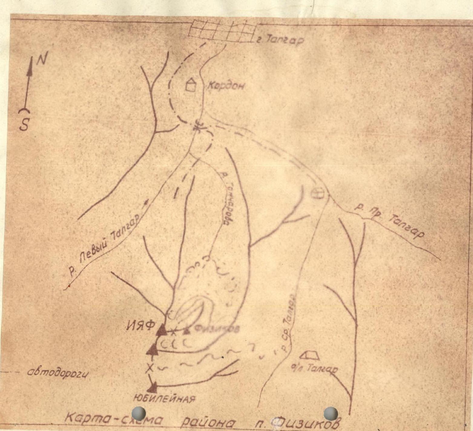
Location and Approaches
Peak Fizikov (3800 m) and Peak IYAF (3900 m) are located in the watershed spur of the Trans-Ili Alatau between the Sredniy and Levyy Talgar rivers. In the spur, where the peaks "Dinamovets", "Dzhamalak-Tau", and "Yubileynaya" are located. They are the northernmost peaks of this spur and are clearly visible from Talgar, Alekseyevka, Almaty tobacco sovkhoz, and the Scientific township of the Institute of Nuclear Physics of the Kazakh SSR Academy of Sciences (photo #1). The peaks are very convenient in terms of approaches from the mentioned settlements.
The driving route from Talgar allows using motor transport up to the entrance to the Goncharov River gorge (the first lateral gorge of the Levotalgar gorge) and takes no more than an hour. The further path to the peaks passes along the Goncharov River gorge, exiting from it onto the moraine formations surrounding Peak Fizikov from the north. The Goncharov River gorge is very picturesque and wild, with:
- numerous waterfalls,
- rich vegetation,
- great interest for people starting to engage in mountaineering.
The path from the motor road to the end of the gorge (to the beginning of the moraine formations) takes about 4–5 hours with a group of 30–40 people (see map). At the end of the gorge, a base camp can be set up for any number of participants with the presence of water and firewood (absolute height 2300–2500 m above sea level).
The further ascent can be made lightly with a return to the same day to the base camp and further to Talgar.
Ascent Route
Exit from the base camp can be recommended at 5:00. Having reached the end of the Goncharov gorge, it is necessary to ascend along the steep ancient moraine, overgrown with grass, straight up. Having overcome the steep grassy slope of the moraine, they reach the medium-stony scree of the moraine type. From here, Peak Fizikov is visible in the form of a sharp rocky massif (photo #2).
The further path goes along a gentle wide moraine in the direction "under Peak Fizikov". The path from the end of the Goncharov gorge to under Peak Fizikov, overcoming all moraine formations, takes a group of 30–40 people about 2.5–3 hours.
Directly under Peak Fizikov, there is water, where you can rest well and have breakfast.
The further path goes around from the northwest the entire rocky massif of Peak Fizikov (photo #3). Initially, along the medium and small scree, then along the snow, they reach the snow basin located between the massif of Peak Fizikov and the western ridge of Peak IYAF (photos #3 and #4).
Having reached the snow basin, one should choose a direction to the snow saddle visible in the south between Peak Fizikov and Peak IYAF (photo #5).
The ascent to the saddle — a steep snowy slope about 35–40° — is completely safe. The path to the saddle from the halt under Peak Fizikov can take about 2 hours.
From the saddle, the ascent along the ridge in the direction to the north leads to Peak Fizikov (photo #6). The ridge is simple. And only before the summit, after a 20-minute walk from the saddle, the ridge has a 10-meter dip, after which a 20-meter rocky wall begins, with a steepness of about 60°.
The rocks are monolithic, rough, and have good holds. Passing the wall requires careful belay. After the wall, it is still necessary to pass 30 m vertically along the rocks with a large number of ledges, outcrops, 1–1.5-meter walls, and reach the summit.
The summit of Peak Fizikov is a rocky platform on which up to 20 people can stand at the same time. To the west and east, the rocks break off with sheer faces. To the north from the summit, a sharp descending ridge goes.
On the summit, a cairn and a metal pole are installed. Descent along the ascent route with careful belay when descending the wall by sports or "sitting on a rope" methods.
If from the saddle (photo #8) one begins to move along the ridge to the southwest, one can reach the summit of Peak IYAF (3900 m a.s.l.). The ridge along its entire length to the summit is snowy with small cornices on the left along the way. It is necessary to ascend along it in rope teams, as in case of an accidental fall — on the right along the way is a steep icy slope on which it is difficult to stop.
The summit of Peak IYAF is a snowy plateau with a rocky outcrop at its highest point. On this outcrop, a cairn is installed. The ascent from the saddle to the summit along the snowy ridge takes 30–40 minutes. Descent along the ascent route.
History of Ascents
For the first time, Peak "3800" was climbed in May 1963 by employees of the Institute of Nuclear Physics of the Kazakh SSR Academy of Sciences with the aim of:
- making a qualifying ascent for the "Alpinist of the USSR" badge;
- giving the peak the name Peak Fizikov.
The number of first ascenders was 30 people.
In June 1965, a second mass ascent to Peak Fizikov was made by employees of IYAF in the amount of 41 people.
Four of them simultaneously made an ascent to Peak "3900" along the described route and named it Peak IYAF.
Conclusion
The described ascent route to Peak Fizikov can be classified as a combined route (snowy-rocky character) and represents a route of 1B cat. diff.
The described ascent route to Peak IYAF is predominantly snowy and can be classified as a route of 1B cat. diff.
Peak IYAF and Peak Fizikov are convenient objects for training novice mountaineers in the area of Talgar, Alekseyevka, Tabaksovkhoz, and the Scientific township of IYAF of the Kazakh SSR Academy of Sciences, Almaty region, and can be:
- Peak Fizikov — qualifying for the "Alpinist of the USSR" badge
- Peak IYAF — training.
Senior instructor, Master of Sports V. Saprykin
Junior instructor, Master of Sports D. Yermilova
Junior instructor, Master of Sports A. Kosmacheva
Institute of Nuclear Physics of the Kazakh SSR Academy of Sciences
• · 0 to 2
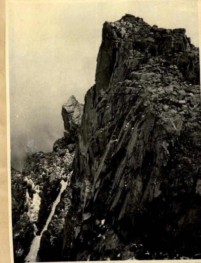
Photo #7. Summit of Peak Fizikov.
Photo #8. Summit of IYAF (view from the ridge of Peak Fizikov)


