
ASCENT DOCUMENT
- Climbing category — rock
- Region — Northern Tian-Shan, Trans-Ili Alatau, Tuyuk-Su gorge.
- Peak — Tuyuk-Su, 4218 m, eastern spur of the northern ridge, combined route.
- Proposed complexity category — 4B.
- Route characteristics: height difference — 600 m length — 900 m average steepness — 41° length of the wall section of the eastern spur — 370 m steepness of the wall section of the eastern spur — 57°
- Pitons hammered: rock — 36/2 ice — 3 Number of placed protection — 11
- Total climbing time — 22 hours
- Overnight stay — one, lying on the shoulder of the eastern spur.
- Group composition.
Leader: Demidov Alexander Alexandrovich — 1st sports category.
Participants:
- Groshikov Vladimir Viktorovich — 1st sports category.
- Laptev Valery Petrovich — 1st sports category.
- Lekanova Lyubov Vasilievna — 1st sports category.
- Team coach: Demidov Alexander Alexandrovich — instructor III category, 1st sports category.
- Date of departure on the route — July 19, 1988. Date of return from the route — July 20, 1988.
- Team of the Gorky Council of the All-Union Voluntary Sports Society of Trade Unions. Climb organized and supported by the AUSB "Talgar".
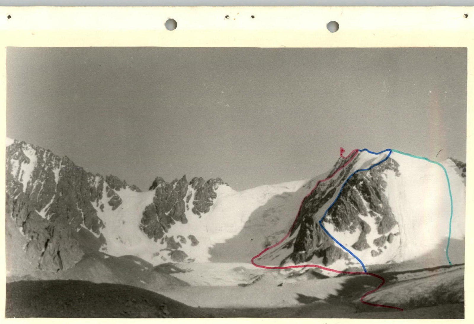
Tuyuk-Su peak, 4218 m. Shot from "Tashkent bivouacs". Group route:
- Eastern spur of the Northern ridge
- Route along the Northern edge 3B category of complexity.
- Route along the North-Western edge 2B category of complexity.
SCHEME of the Little Alma-Ata gorge and the Bogdanovich glacier

Description of the approach to the route
From the branch of AUSB "Tuyuk-Su" (see map) along the right bank (orographic) of the Malaya Almatinka river along the road to the Mynzhilki dam. After crossing the river over the stones under the final scree of the Tuyuk-Su cirque glaciers, turn left from the road upwards along the trail to the fork in the road to the glaciological base of the Academy of Sciences of the Kazakh SSR and the Tuyuk-Su glacier.
Along the road leading to the Tuyuk-Su glacier, exit to the "Tashkent" bivouacs (from the branch to the bivouacs — 2 hours). Here the group set up a bivouac. From the "Tashkent" bivouacs, the path under the route goes along the road under the Tuyuk-Su glacier. Along the right (orographic) side of the Tuyuk-Su glacier, ascent along the median moraine ridge between the Tuyuk-Su and Igly Tuyuk-Su glaciers. Crossing the moraine in the upper part under the slopes of the Tuyuk-Su peak, exit to the Igly glacier. Along the glacier, along the slopes of the northern ridge, approach under the Eastern spur. From the bivouac — 2 hours.
It is possible to bivouac on the "gray" moraine of the Igly glacier. In this case, the approach to the route is 30 minutes.
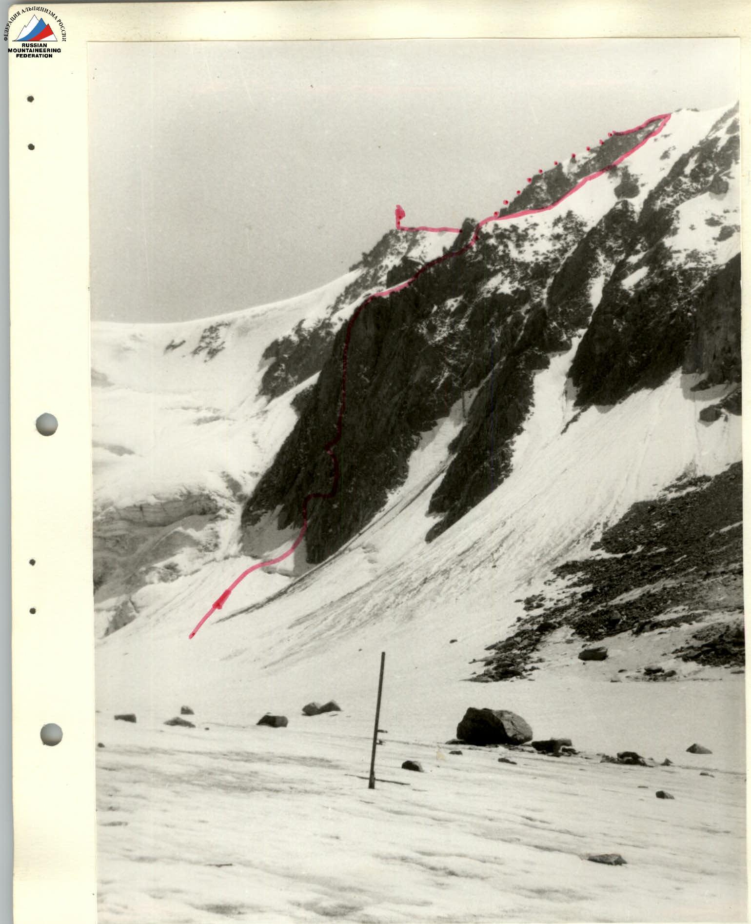
Eastern spur of the Northern rib of Tuyuksu peak. Shot from the Igly Tuyuksu glacier
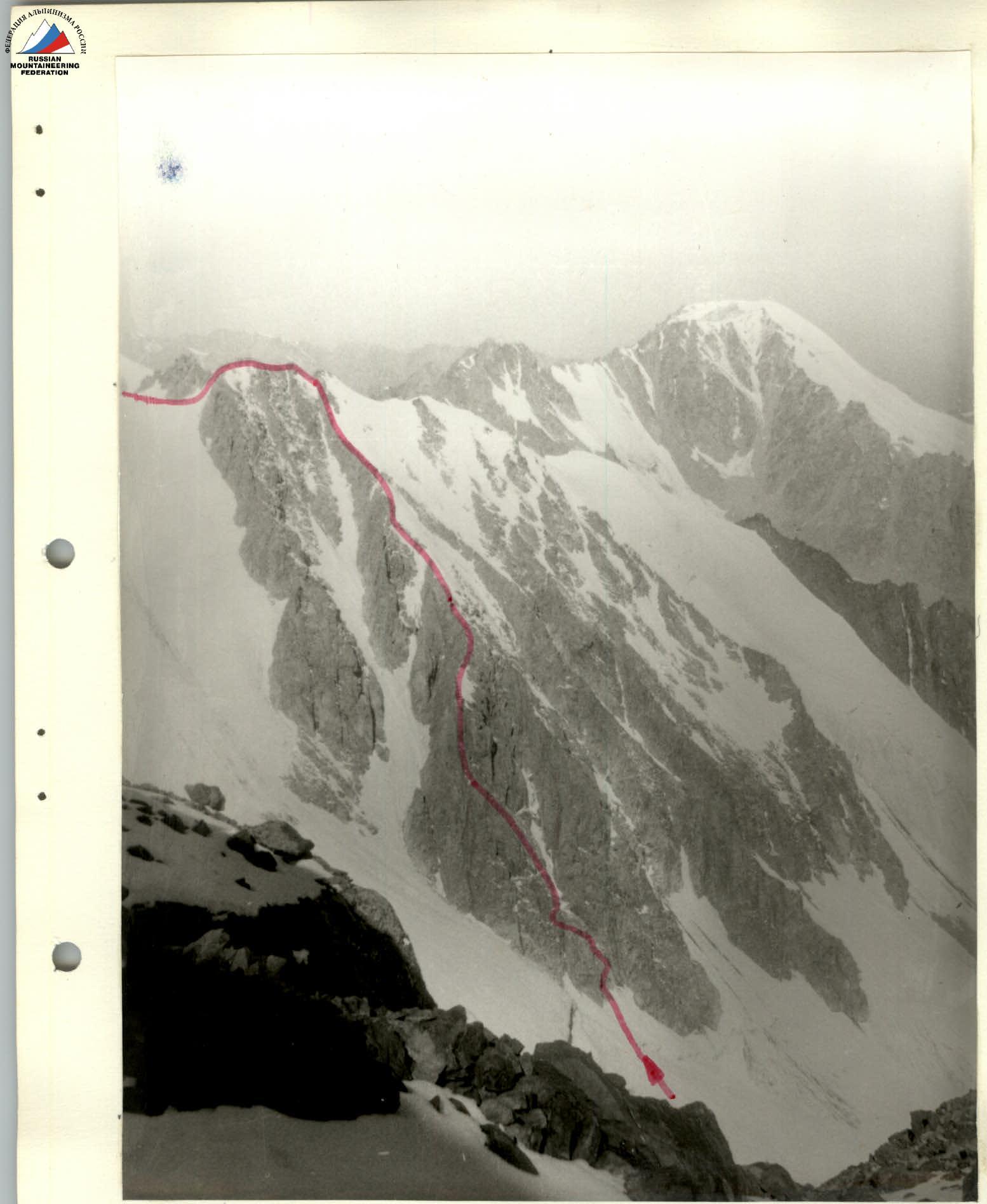
View of the Northern rib and Eastern spur of the Northern rib from the pass between the 6th and 7th Igly Tuyuksu
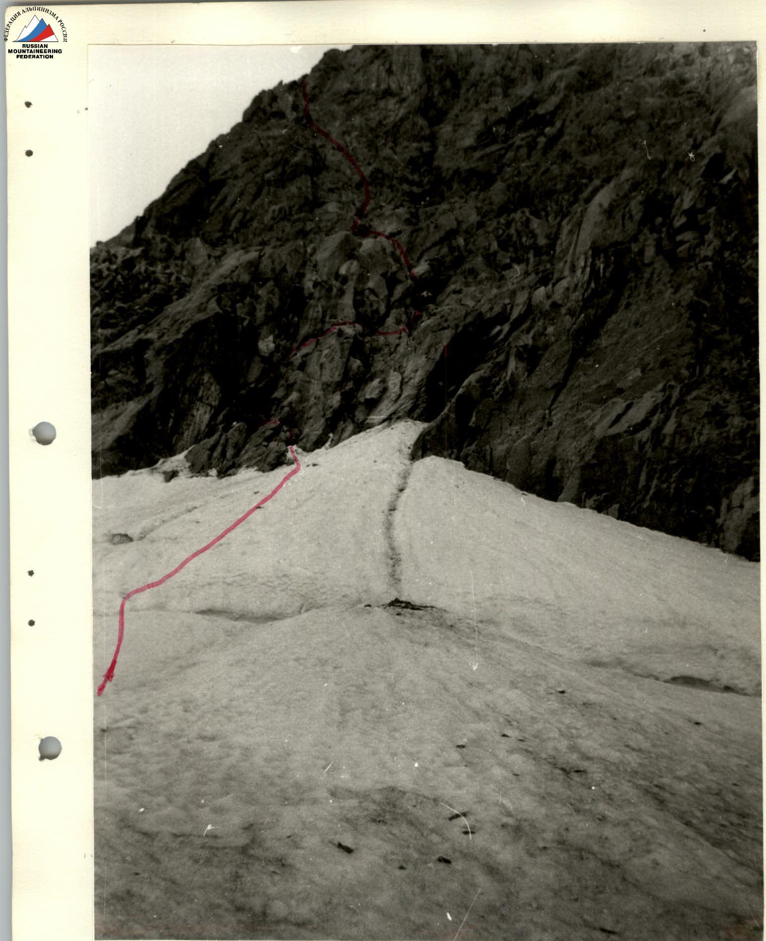
Lower part of the Eastern spur of the Northern rib. Shot from section R0.
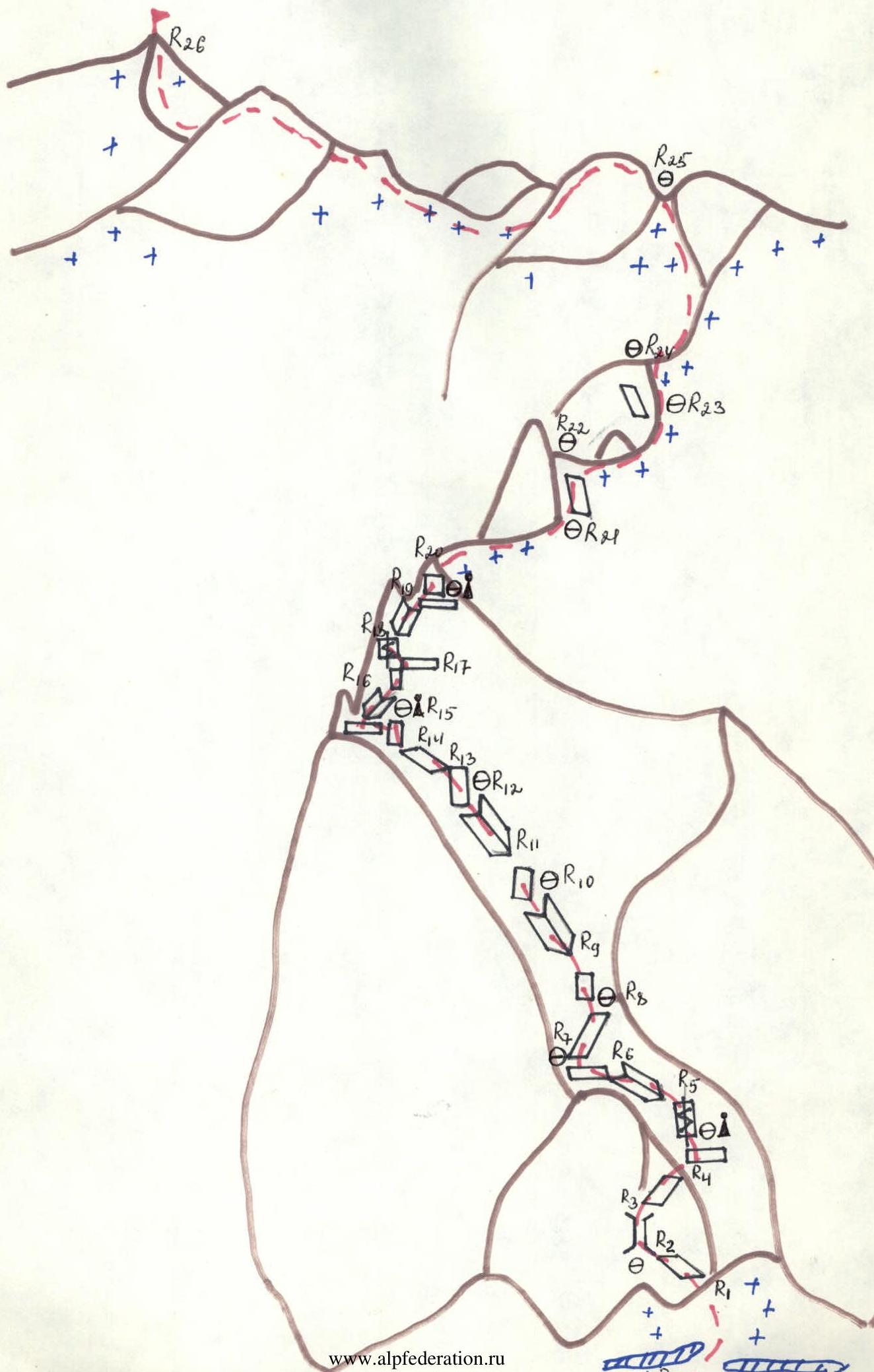
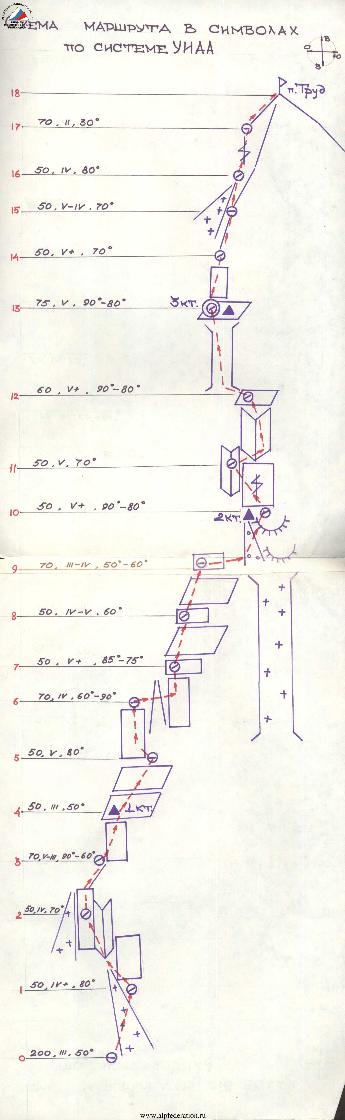
Route scheme in UIAA symbols
Characteristics of the route sections
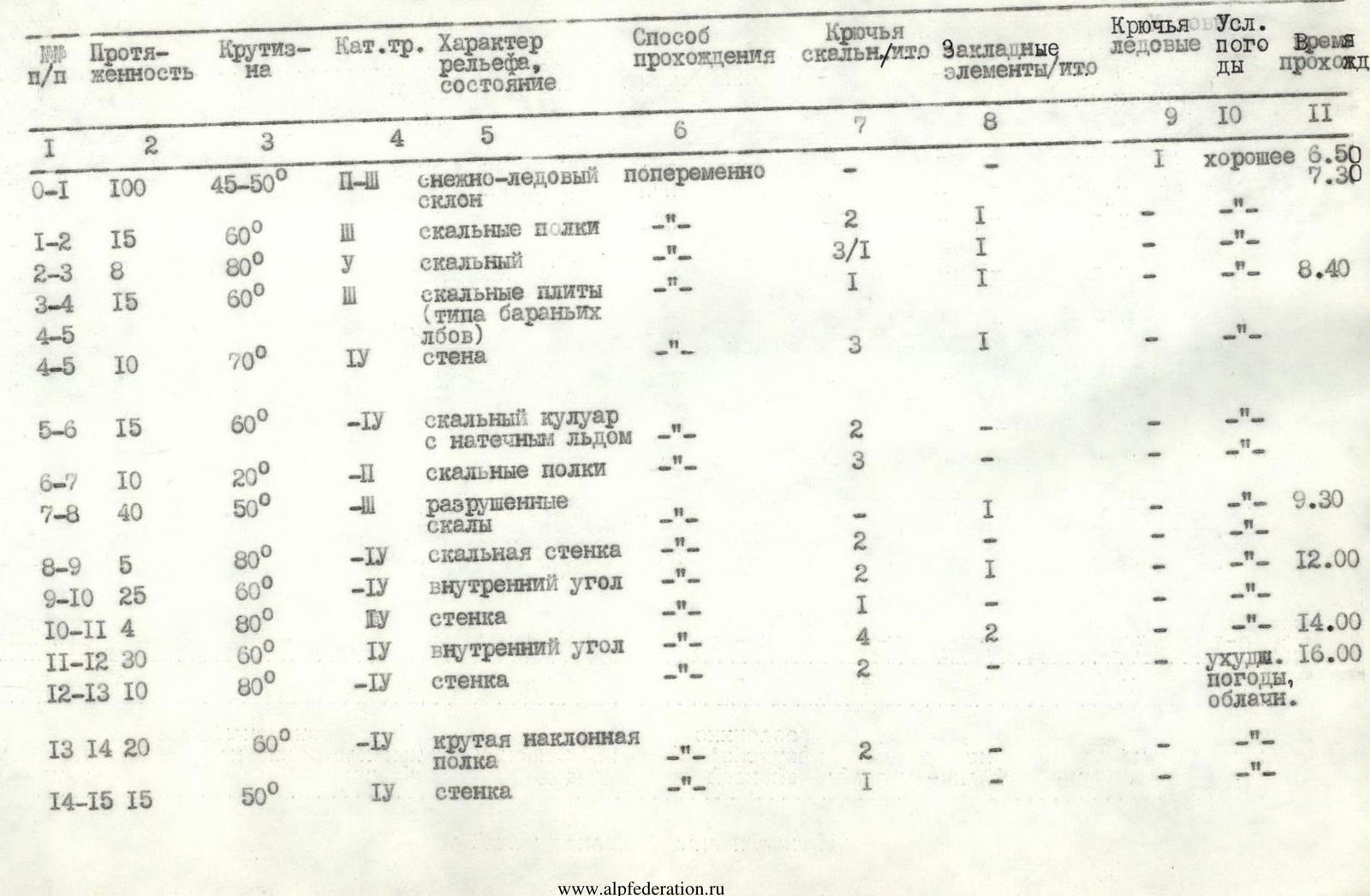
| № | Length | Steepness | Category | Character of relief, condition | Method of passage | Rock pitons/cams | Protection/cams | Ice pitons | Weather conditions | Time taken |
|---|---|---|---|---|---|---|---|---|---|---|
| R0–R1 | 100 | 45–50° | 2–3 | snow-ice slope | alternating | - | - | 1 | good | 6:50 |
| 7:30 | ||||||||||
| R1–R2 | 15 | 60° | 3 | rock ledges | -" | 2 | 1 | - | -" | |
| R2–R3 | 8 | 80° | 5 | rock | -" | 3/1 | 1 | - | -" | 8:40 |
| R3–R4 | 15 | 60° | 3 | rock slabs (like "ram's foreheads") | -" | 1 | 1 | - | -" | |
| R4–R5 | 10 | 70° | 4 | wall | -" | 3 | 1 | - | -" | |
| R5–R6 | 15 | 60° | 4 | rocky couloir with ice | -" | 2 | - | - | -" | |
| R6–R7 | 10 | 20° | 2 | rock ledges | -" | 3 | - | - | -" | |
| R7–R8 | 40 | 50° | 3 | destroyed rocks | -" | - | 1 | - | -" | 9:30 |
| R8–R9 | 5 | 80° | 4 | rock wall | -" | 2 | - | - | -" | |
| R9–R10 | 25 | 60° | 4 | internal corner | -" | 2 | 1 | - | -" | 12:00 |
| R10–R11 | 4 | 80° | 5 | wall | -" | 1 | - | - | -" | |
| R11–R12 | 30 | 60° | 4 | internal corner | -" | 4 | 2 | - | -" | 14:00 |
| R12–R13 | 10 | 80° | 5 | wall | -" | 2 | - | - | worsening weather, cloudy | 16:00 |
| R13–R14 | 20 | 60° | 4 | steep inclined ledge | -" | 2 | - | - | -" | |
| R14–R15 | 15 | 50° | 4 | wall | -" | 1 | - | - | -" | |
| R15–R16 | 10 | 60° | 3 | internal corner | alternating | - | - | - | thunderstorm, hail | 18:00 |
| R16–R17 | 10 | 60° | 3 | wall | -" | 2 | - | - | cloudy, rain | |
| R17–R18 | 4 | 80° | 5 | wall with a cleft | -" | 2/1 | - | - | cloudy | |
| R18–R19 | 20 | 70° | 5 | internal corner | -" | 2 | 2 | - | cloudy | 19:00 |
| R19–R20 | 6 | 90° | 5 | rock — wall | -" | - | - | - | -" | |
| R20–R21 | 50 | 20° | 2 | snowy ridge with rock outcrops | -" | - | - | - | -" | 20:00 |
| R21–R22 | 40 | 50° | 3 | steep snowy rocks | -" | 1 | 1 | - | -" | 21:00 |
| R22–R23 | 50 | 20° | 2 | snowy ridge with rock outcrops | -" | - | - | - | good | 8:00 |
| R23–R24 | 50 | 50° | 3 | snowy slope with rock outcrops | -" | 1 | - | - | -" | |
| R24–R25 | 140 | 45–50° | 3 | -" | -" | - | - | - | -" | 9:20 |
| R25–R26 | 250 | 20–60° | 2–3 | snowy-ice ridge with rocky pinnacles | simultaneous and alternating | - | - | 2 | -" | 10:40 |
Explanation for the table of route sections
Section R0–R1
Snow-ice slope of average steepness 45–50°, leading to the rocks of the spur. The bergschrund is overcome via a snow bridge. Insurance through ice axes and ice screws. Alternating movement.
Section R1–R2
Rock ledges with a steepness of up to 60°. Movement is to the left towards a narrow chimney. When moving straight up, rockfall is possible from above. On the ledge under the chimney, the 1st belay station is organized behind a monolithic outcrop. Insurance through rock pitons and protection.
Section R2–R3
Narrow chimney — a cleft. Movement is on the left side. Artificial aid was used when passing. Insurance through pitons and protection.
Section R3–R4
In the middle part of the chimney, along narrow ledges with a steepness of up to 60°, move to the right under a wet wall. Under the wall, there is a small horizontal ledge where the 2nd belay station is organized behind an outcrop. To the right, slightly below, on a ledge 6–8 meters away, the 1st control cairn is laid. The character of the rocks up to the 1st control cairn is monolithic rocks with small smooth outcrops covered with rock debris — rocks like "ram's foreheads".
Section R4–R5
To the left of the belay station, a stream flows down the wall. From the R4–R5 belay station, to the right of the stream, climb up the wet wall with a cleft and small holds to a small narrow ledge that goes to the left towards the stream. Insurance is intermediate through pitons.
Section R5–R6
From the ledge, exit to an internal corner with ice. The stream flows from here. Pitons are hammered with difficulty. Chipped ice flies towards the belay station but falls 2 meters below it. Part of the group can be placed on a safe ledge at the 1st control cairn. This section is exposed to rockfall — stones periodically fall from above along the internal corner.
Section R6–R7
From the internal corner, exit to wide scree ledges. Here is the 3rd belay station (3 pitons are blocked). The entire group can assemble here. From here, the ascent route is visible up to the exit to the ridge of the eastern spur.
Section R7–R8
Simple rocks with a steepness of up to 50° with many "live" stones. The easiest section on the spur. Intermediate insurance through outcrops and protection. Movement is to the right and upwards towards the middle internal corner on the left side of the cirque couloir. To the right, along the groove, stones fall from the snow slope above the spur. Further movement is along the internal corner, interrupted by ledges — walls.
Section R8–R9
Low wall, rocks of medium difficulty. Pitons are hammered well. Under the wall, the 4th belay station is organized behind a blocked outcrop and a rock piton.
Section R9–R10
Internal corner of average steepness up to 60°. Movement is along the corner from left to right. Intermediate insurance through pitons and protection.
Section R10–R11
Small steep wall up to 80°. Under the wall, the 5th belay station is behind a rock outcrop. Pitons are hammered well.
Section R11–R12
From the wall, exit to an internal corner with a steepness of up to 60°. There are many "live" stones in this section. At the end of the corner, before the wall, the 6th belay station is organized (3 pitons are blocked). The 4th, 5th, and 6th belay stations are located under the walls — ledges of the internal corner, which protect climbers from possible rockfall from under the feet of the preceding climber. The disadvantage is that they exclude the possibility of visual observation of the first climber. Gathering on the station for more than 3 people is difficult because the ledges for feet are small and inclined, and there are many "live" stones. Short self-insurance is used for rest and working with the rope.
Section R12–R13
Wall with a cleft. Passed on the left side. Artificial aid was used when the first climber moved.
Section R13–R14
Steep inclined rock ledge with a cleft, steepness up to 60°. When moving along the rope, it swings.
Section R14–R15
Small wall of medium steepness. Ends with a ledge — a balcony. Above it, there is a large rock cleft, behind which the 7th belay station is organized. Here the entire group can assemble, and a sitting bivouac is possible. 2nd control cairn.
Section R15–R16
Bypassing the rock cleft on the left, ascent along a short internal corner with a steepness of 60°. Rocks of medium difficulty.
Section R16–R17
Small wall — a ledge, ending with a good horizontal ledge.
Section R17–R18
Steep wall with a cleft, turning into a trough-like internal corner. When the first climber moved, artificial aid was used. There are cracks for piton insurance.
Section R18–R19
Steep trough-like internal corner. Intermediate insurance through protection and pitons. The rocks are monolithic. When exiting the internal corner to the right, there is a good ledge with piled blocks. 8th belay station behind a block. 3rd control cairn.
Section R19–R20
From the horizontal ledge, climb upwards along boulders under a smooth vertical wall without cracks. Passed by "boosting", the second climber stood on the shoulders of the first. From the site, it is possible to bypass this wall to the right along strongly destroyed steep rocks, but the path along the wall is safer.
Section R20–R21
Simple, not steep snowy ridge with rock outcrops. The beginning of the ridge part of the spur. After the second climber joined from the wall, movement is simultaneous.
Section R21–R22
Large rock "tooth" on the ridge, visible from the bivouacs, a reference landmark. Bypassed to the right along steep destroyed and snowy rocks, alternating. Insurance through outcrops and pitons.
Section R22–R23
Simple snowy ridge. Simultaneous movement. Here the group set up a bivouac, having cut part of the ridge.
Section R23–R24
Snowy slope with outcrops of destroyed rocks. Alternating movement, insurance through outcrops.
Section R24–R25
Snowy slope of average steepness with rock outcrops, simultaneous movement, insurance through outcrops.
Section R25–R26
Northern ridge of Tuyuk-Su (route 3B category of complexity) — a wavy ridge. Alternation of rocky ascents and snowy slopes. Simultaneous movement. The pre-summit snowy-ice slope up to 60° is passed with piton insurance.
Tactics of route passage
Before exiting to the route, the group observed the spur of the northern ridge through binoculars from the "Tashkent" bivouacs.
Clarification of movement along the spur was made during the approach and ascent to the Igly Tuyuk-Su peaks via route 4A category of complexity, taking into account safe movement, the main rockfall routes on the spur were examined, reference landmarks on the route and places suitable for a group bivouac were identified.
On the route, the group worked in two pairs — doublets: Demidov—Lekanova, Laptev—Groshikov.
To enhance safety when the first climber moved on the spur, a second rope was used. On sections R1–R7, R8–R20 of the spur, interaction between the pairs was carried out.
Before exiting to the northern ridge (route 3B category of complexity), the group moved alternately with piton insurance (on section R20–R25, insurance was through outcrops).
Belay stations were mainly made behind monolithic rock outcrops located under the walls, which protected against possible rockfall when the first climber moved. The change of the lead climber was carried out after each station. Extension loops were used at all intermediate points due to the strong articulation of the route.
The time schedule of the ascent was built taking into account a bivouac on the northern ridge or in the upper part of the spur on a snowy shoulder. When exiting to the route, the group took bivouac equipment, which was used for the overnight stay.
Radio communication with the base was carried out using the "Karat" radio station according to the schedule.
During the ascent, participants used "pocket" nutrition, which was planned during preparation for the ascent due to the impossibility of gathering the group on the spur because of the limited size of the ledges; hot meals were had during the overnight stay.
Comments
Sign in to leave a comment