Ascent Passport
- Ascent class — rock climbing
- Ascent area — Tian-Shan, Trans-Ili Alatau ridge, Middle Talgar gorge.
- Peak TAGANAI, 3800 m, southeast ridge.
- Presumed complexity category — 2B
- Route characteristics: elevation gain — 470 m, length of 5th category difficulty sections — none, average steepness — 35°.
- Pitons driven: for belaying: rock — 5, ice — none, bolt — none, for creating artificial holds — none.
- Number of climbing hours — 6 hours
- Number of nights on the route — none
- Ascent participants:
- Meshkov Igor Nikolaevich — Master of Sports
- Petrashko Grigory Arsenyevich — Master of Sports
- Team coach — Ganyalin V.A.
- Date of departure and return — June 18, 1978
The Taganai peak is located in the northern spur (Alatas) of the Trans-Ili Alatau ridge, north of the Tys pass, and is the last significant peak of this spur. A bivouac, from which it is convenient to ascend Taganai, is located in a wide mountain valley known as the "Valley of the Scythians".
Map of the Ascent Area
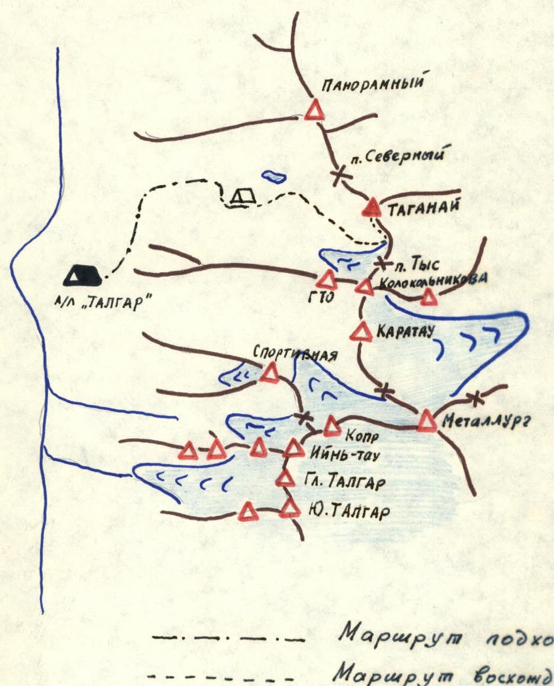
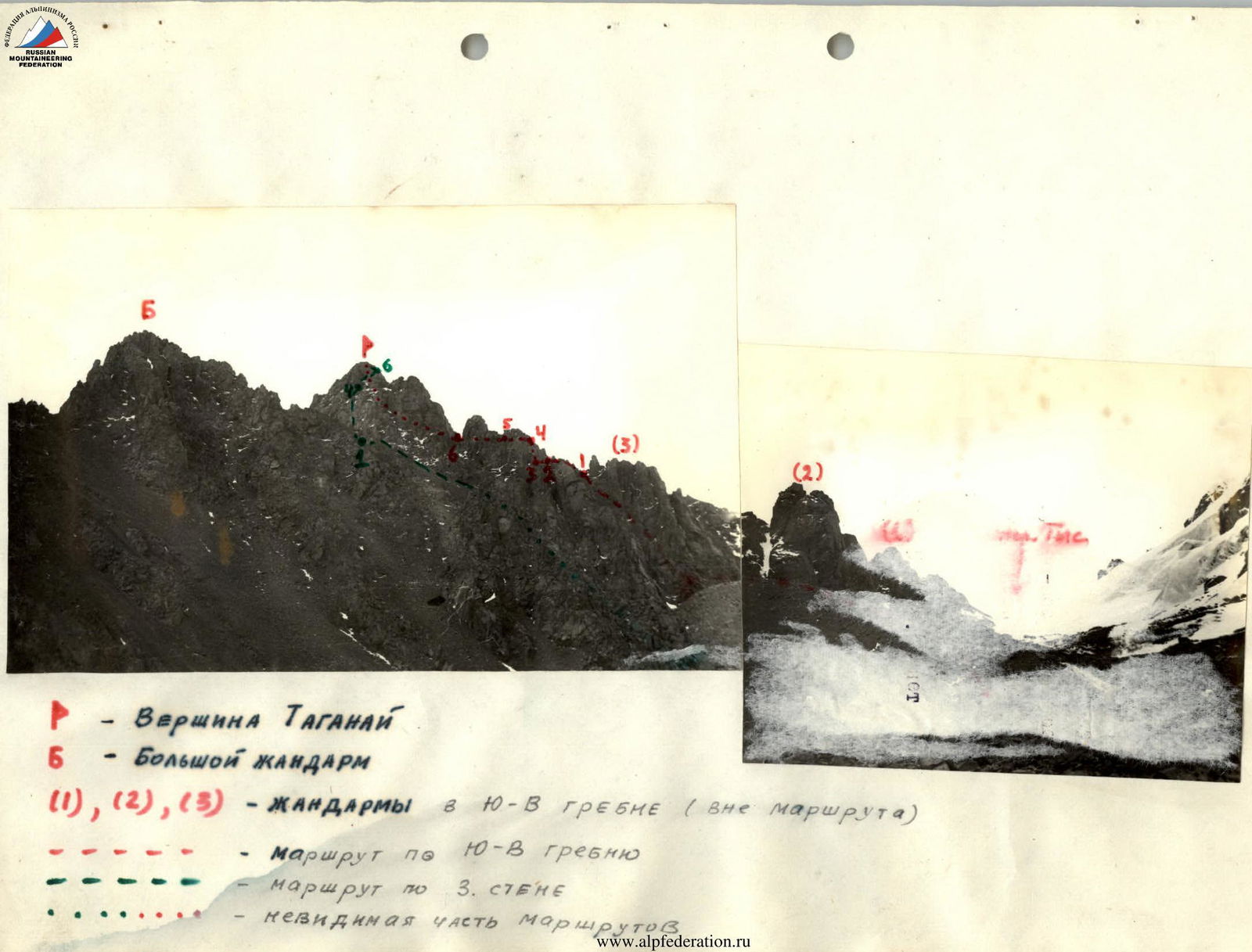
Table of Main Route Characteristics
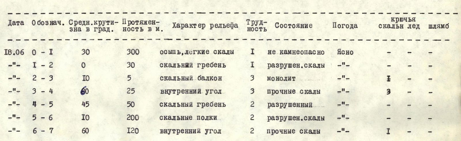
| Date | Designation | Average steepness in degrees | Length in m | Terrain characteristics | Difficulty | Condition | Weather | Pitons (rock, ice, bolt) |
|---|---|---|---|---|---|---|---|---|
| 18.06 | R0–R1 | 30 | 300 | scree, easy rocks | 1 | not rockfall-prone | Clear | ––– |
| –"– | R1–R2 | 0 | 30 | rocky ridge | 1 | destroyed rocks | –"– | ––– |
| –"– | R2–R3 | 10 | 5 | rocky balcony | 3 | monolithic | –"– | ––– |
| –"– | R3–R4 | 60 | 25 | inner corner | 3 | solid rocks | –"– | 3–– |
| –"– | R4–R5 | 45 | 50 | rocky ridge | 2 | destroyed | –"– | ––– |
| –"– | R5–R6 | 10 | 200 | rocky ledges | 2 | destroyed rocks | –"– | ––– |
| –"– | R6–R7 | 60 | 120 | inner corner | 2 | solid rocks | –"– | 1–– |
Description of the Approach to the Start of the Route
From the "Talgar" alpine camp, follow the trail in a northeasterly direction past the helicopter pad to the "Dry Log", then to the "Panoramic Point". Then follow the trail along the grassy ridge to the "Valley of the Scythians". Here, in a wide hanging valley with a lake, there are convenient areas for overnight stays. The approach to the overnight stay site from the camp takes 2–2.5 hours.
From the bivouac, move east across the hills covered with grass towards the old moraine of the Malyutka glacier, which flows from the Tys pass. 1 hour of walking. Ascend the moraine via large stones on the left, near the rocks (about 40 minutes), and then along the lateral moraine for 40 minutes to the base of the couloir, which leads to the saddle on the SE ridge of the peak, behind the third gendarme from the Tys pass. Here is the control cairn and the start of the route.
Footnotes
-
P — Peak TAGANAI Б — BIG GENDARME (1), (2), (3) — GENDARMES ON THE SE RIDGE (off-route)
-
-
- route along the SE ridge
-
-
- route along Wall 3 ...... invisible part of the routes
-