DESCRIPTION
First Ascent of the North Face of "Bezbozhnik" Peak (4360 m)
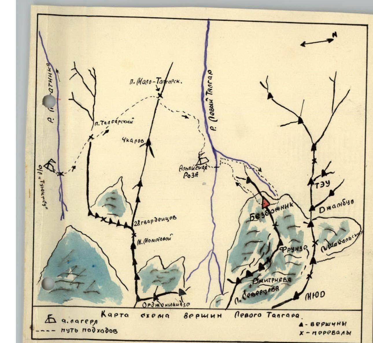
The "Bezbozhnik" peak is located in the ridge that separates the S. Stal'skii glacier to the north and the Frunze glacier to the south; both glaciers feed the tributaries of the Left Talgar River. To the east, "Bezbozhnik" is separated from the Frunze peak by the Frunze pass, and to the west, a short rocky-snow ridge connects it to a nameless peak.
The "Bezbozhnik" peak consists of several rocky towers connected by ridges. The highest point is the "pero" gendarme on the central tower. This tower is distinct from the northern tower, which is visible from the S. Stal'skii glacier cirque and the Talgar pass as the "Bezbozhnik" peak. To the south of the central tower stands the southern tower of the same height as the northern one.
From the northern tower, a steep counterfort descends northeast to the S. Stal'skii glacier. The tower drops off to the north with an almost sheer wall, approximately 650 m high. The lower part of the wall's base is snowy, about 150 m, and above the bergschrund, it's icy, about 75 m, with a steepness reaching 70° in the upper part. Further up, there's a rocky wall, partially snow-covered, not lit by the sun due to its northern aspect.
On September 8, 1958, the assault team consisting of: – Stepanov V.V. — 1st sports category, – VEITSman R.I. — 2nd sports category, with a support group of 4 people led by m.s. KORENEVA I.E., left the abandoned camp in the Left Talgar gorge at 14:30. They crossed the Left Talgar River on a log to the right bank and went downstream. 150–200 m from the crossing, a stream flows into the Left Talgar, along which a trail leads to the S. Stal'skii glacier and the TEU pass. Moving along the stream first on the left (orographic) side, then crossing to the right side, the group entered a valley filled with moraine. Ascending the right orographic bank of the moraine into the depths of the gorge, the group set up a bivouac at 19:00 near a stream descending from a spur coming from Kishkin- Tau. This bivouac became the group's main base.
On September 9, there was bad weather.
On September 10, the assault duo ascended to the snow plateau under "Bezbozhnik" peak and laid out an overnight area on the moraine, lower down the glacier. From here, the duo departed at 12:00 and climbed a steep snow slope (about 150 m) with a slope of up to 55° to the bergschrund. Here, they put on crampons and, using a motik (ice axe), overcame the bergschrund, climbing 40 m on the front teeth of crampons up a 60° ice slope with ice screw placements.
Here, they placed a rock anchor. Overcoming a 1.5-meter sheer wall, they ascended another 30 m on ice with ice screw placements. The slope's steepness reached 70° here.
Further on, they encountered rocks and ascended 10 m with piton protection, placed a piton, and rappelled down 80 m (two ropes) to the bergschrund by 15:00 and then returned to the base camp.
On the same day, the duo, leaving their crampons behind, exited the base camp and bivouacked at 20:00 in a Zdars'ki tent under the peak on a previously prepared site.
On September 11, at 5:45, the duo began their ascent. By 7:30, they had completed the previously prepared section and dropped one of the ropes. From here, they moved right-upward for 40 m along a weakly defined couloir with a steepness of about 75° on snow-covered and ice-glazed rocks.
10 m shy of a sheer wall, they moved to the right side of the couloir, then approached under an overhanging wall on gentle rocks. Under the wall, along a narrow ledge, they moved right for 15 m and entered a wide, steep crevice, ascending 5 m. To the right, there's a platform with a control cairn.
From the control cairn, they returned left, crossed the crevice again, and moved 15 m up-left along a very narrow ledge, approaching the overhanging wall at 10:00. Further, they needed to overcome the wall: – In the lower part, about 2–3–5 m with a negative slope — four pitons were placed for protection; – Above — a 10 m chimney with an 80° steepness and few holds; – The chimney was climbed using body tension and under a "plug," they exited right to a platform; – The backpack was pulled up on a rope above the "plug."
On the platform at 12:00, a cairn was left. From here, they moved right along a wide ledge for 10 m. Above the ledge, a wall rises, which they climbed using very difficult, brittle rocks for 40 m upward. The steepness in the lower part was about 75°, becoming gentler at the top.
They moved right, climbed along a weakly expressed angle, and from it, right into a weakly expressed couloir. From here, they moved another 5 m right and, having ascended 20 m along a weakly defined ridge, reached a snow-filled platform at 14:00, from which they could belay through a ledge (the first encountered on the route).
From here, right-upward, they ascended 20 m on rocks of medium difficulty, reached a ledge, and moved right along it for 10 m. Here, at 14:20, the third control cairn was built. From here, they ascended 80 m on rocks of medium difficulty and reached the saddle between the northern gendarme and the northern tower of the peak by 15:00.
Here, there's a large platform from which they continued at 15:20. The gendarme connects to the tower via a straightforward 20-meter ridge. Further, the path leads to the tower. The tower is a monolithic obelisk nearly without cracks, 70 m high; overcoming it directly without using bolts and expansion pitons is entirely impossible.
From the ridge, they ascended the tower up-left along very steep snow-covered slabs with smoothed holds for 40 m, managing to place three unreliable pitons along the way. At the top, there's a wide horizontal ledge.
They moved along the ledge left to a vertical 3-meter crevice, overcame it, and exited onto an easy summit ridge between the central and northern towers.
No cairn was found on either tower. They built a cairn on the central tower under the "pero" at 18:00.
The descent from the summit followed the ridge westward to the nameless peak: – Along snowfields, avoiding crevasses, they approached under the wall of the nameless peak, descended a steep snowfield and a rocky couloir to the plateau near the assault bivouac.
The descent from the summit took about 1.5 hours.
The group placed 34 rock pitons and 5 ice screws during the ascent. Rock pitons were placed unreliably as suitable cracks for piton placement are rare, and upon placement, the surrounding rock would crack.
For the ascent of "Bezbozhnik" via the north face, the group of two had the following equipment:
- Zdars'ki tent — one;
- Main rope — one 40 m length;
- Rock hammer — one;
- Ice axe — one;
- Ice axe — one;
- Backpack — one;
- Rock pitons — 16 pieces;
- Ice screws — 4 pieces;
- Carabiners — 8 pieces;
- Down sleeping bag — one;
- Crampons for preliminary route preparation — two pairs;
- Food for two days, weighing 1200 g for two people.
ROUTE RECOMMENDATIONS
We recommend ascending "Bezbozhnik" via the north face with a group of two, with an observation team present.
Ascending as a duo is advisable due to the presence of loose rocks on the entire wall up to the summit tower. A group tackling the north face of "Bezbozhnik" should have good cohesion and have previously completed several wall ascents of 4th or 5th category difficulty together, as ascending the north face of "Bezbozhnik" is highly complex and requires high rock climbing skills and good teamwork: – High rock climbing technique; – Good teamwork.
The group consisting of Veitsman R.I. and Stepanov V.V. had been making sports ascents of 4–5 category difficulty together for four years.
We recommend that a group undertaking this route: – Preliminarily process the snow-ice slope and hang fixed ropes, for which an additional 40-meter rope is taken and then dropped from the wall.
Then, leave crampons at the bivouac as they are not needed higher up.
The first ascent of "Bezbozhnik" peak was made by a group from the Leningrad Regional Council of the "Trud" Sports Society, consisting of:
- Stepanov V.V. — 1st sports category;
- Veitsman R.I. — 2nd sports category.
Comparing the difficulty of the route taken to "Bezbozhnik" peak via the north face with previously completed routes by the group members to peaks:
- Pik Shurovskogo — 5B category difficulty;
- Talgar (west wall) — 5B category difficulty;
- Koshtak-Tau — 5B category difficulty;
- Ushba — 5A category difficulty;
- Dombai-Ul'gen — 5A category difficulty;
- Ak-Tau — 5A + 1 category difficulty.
The group believes that the route to "Bezbozhnik" peak via the north face surpasses all previously completed routes of the fifth category difficulty in technical complexity, but due to the wall's relatively short length, we classify it as 5A category difficulty.
Description compiled on September 13, 1958. Ascent participants: (Stepanov V.V.) (Veitsman R.I.)
True to the original. Original document.