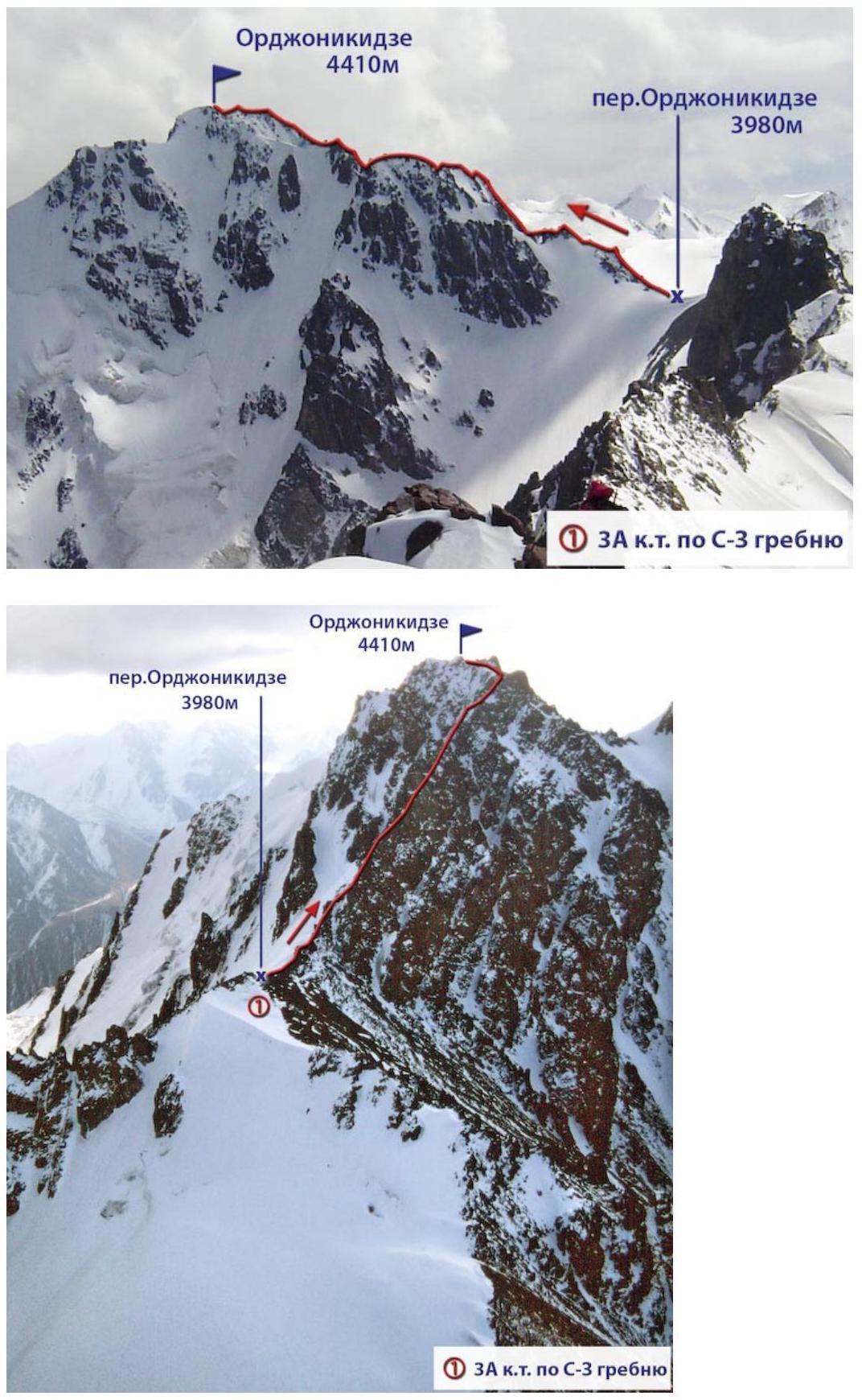
Orjonikidze via SW slope along the NE ridge from Orjonikidze Pass
Route description.
Peak Orjonikidze is located in the central part of the Malo-Almatinsky spur, is the highest point in this area. It is a large rocky massif with lateral ridges extending to the northwest and northeast, has significant glaciation:
- the East Orjonikidze glacier descends into the lateral valley of the Left Talgar;
- it is framed by the West Orjonikidze hanging glacier on the western side.
The starting bivouac is at Orjonikidze Pass (3980 m). The approach to it is through the Tuyuk-Su glacier and its right lateral moraine, the Tuyuk-Su Needles glacier, and then to the foot of the pass. After overcoming a large talus, exit to the middle, and in the upper part of the slope - to the fine talus. The ascent length is up to 300 m.
The ascent begins in a southerly direction:
- along the talus,
- then along easy rocks turning into a crumbling ridge.
At the end of the ridge there is a gendarme, which is overcome head-on along a 10 m long slab with a steepness of 45–50°. Descent is made along a 20-meter wall using a rope.
There are variants for bypassing the gendarme:
- to the right - along a stone-hazardous couloir,
- to the left - along an icy slope with a steepness of up to 50° and a large depth of fall.
Beyond the gendarme:
- there is a small firn area,
- followed by 13–15 m long rocks,
- exit to easy rocks,
- then into a wide couloir.
Further, one can go:
- along the couloir,
- or along the rocks on the left side.
This path leads to a saddle between a rocky tower and a ridge. Beyond this section, there is a rocky ridge steeply dropping down to the saddle. After overcoming it, traverse to the right along the wall for 50 m. Insurance is provided by pitons.
Immediately beyond the wall, a couloir begins (up to 20 m) with fine talus (stone-hazardous!). Above it, there is an exit to the pre-summit ridge, and along it - to the summit.
The summit is a wide ridge covered with rocky fragments, on one of which there is a cairn. This is the main (northern) summit. The second - southern summit - is located at a distance of 250–300 m. The path to it is along difficult rocks with traversing a steep icy couloir.
From the pass to the southern summit of Orjonikidze - 6.5–7 hours of walking. Descent along the ascent route takes about 4 hours.
The first ascent was made on August 11, 1936 by a group of Almaty climbers consisting of: V. Andrieishin, O. Balanina, V. Zyablina, N. Novikov under the leadership of S. Mamontov.
Recommendations:
- Number of participants: 6–8 people.
- Starting bivouac at Orjonikidze Pass.
- Departure from the bivouac not later than 7:00.
- Equipment for a group of 4 people:
- main rope — 2 × 30 m
- expendable reepschnur — 15 m
- rock pitons — 4–5 pcs.
- chocks — 2 sets
- ice screws — 4–5 pcs.
- carabiners — 4 pcs.
- hammers — 2 pcs.
 Author:
Zhunusov B. Source: Book "Climbing routes. Trans-Ili Alatau". Part
1 from Mountain.kz website
Author:
Zhunusov B. Source: Book "Climbing routes. Trans-Ili Alatau". Part
1 from Mountain.kz website
