Ascent Certificate
- Ascent class — combined
- Ascent area — Northern Tian-Shan, Trans-Ili Alatau ridge.
- Peaks — Mayakovsky Peak (4208 m), Ordzhonikidze Peak (4410 m), Partizan Peak (4390 m), Tuyuksu Spires (4218 m), Tuyuksu Peak (4218 m), route — traverse of 5 peaks.
- Estimated difficulty category — 5A in winter
- Route characteristics:
- height difference — 900 m.
- average steepness — 45°
- length of sections with 5th category difficulty — 95 m.
- Pitons hammered:
- for belaying — 41, for creating belay anchors — none
- rock pitons — 31
- ice pitons — 10
- bolt pitons — none
- Number of travel hours — 31
- Number of nights on the route — 2
- Traverse participants:
- Lunyakov G.E. — Candidate for Master of Sports, team leader
- Shapovalov V.N. — Candidate for Master of Sports, participant
- Pryanikov S.G. — Candidate for Master of Sports — «—»
- Agishev R.G. — Candidate for Master of Sports — «—»
- Feofanov A.V. — 1st sports category — «—»
- Team coach: Ilyinsky E.T.
- Date of departure on the route — February 16, completion of traverse — February 18, 1979.
Brief Description of the Approach to the Route
From the high-altitude base of SAVO "Tuyuksu", go up the gorge along the road past the "Mynzhylky" station to the moraine of the Tuyuksu glacier. Then along the moraine through deep snow, bypassing the counterfort going west from Mayakovsky Peak, then along the right edge of the Ordzhonikidze glacier moraine to the rock massif of the peak. Here is the start of the route. The approach from "Tuyuksu" takes 5 hours.
Brief Explanation of the Table
The passage of the route in February is complicated by an abundance of snow, frosts, iced rocks on the slopes of northern exposure, and the presence of extensive areas of open ice on the ridges and slopes. The most difficult sections for passage were: passing the "plug" on Mayakovsky Peak (R2–R4), exiting to the saddle of the pre-summit ridge of Ordzhonikidze Peak (R10–R11), and overcoming the ice section on Partizan Peak (R17–R18).
A detailed description of the traverse route, completed by the group led by Maryashev A.N. in 1966, is attached.
Table of Main Route Characteristics
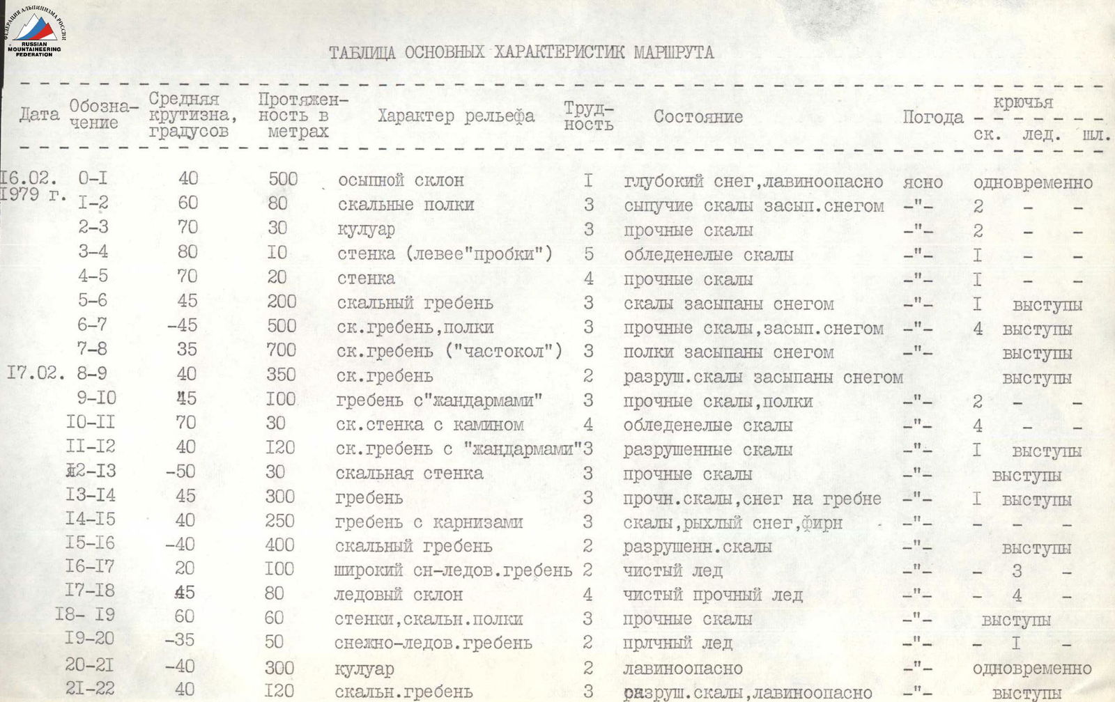
| Date | Designation | Average steepness, ° | Length in meters | Terrain characteristics | Difficulty | Condition | Weather | Pitons (rock, ice, bolt) |
|---|---|---|---|---|---|---|---|---|
| 16.02. | R0–R1 | 40 | 500 | talus slope | 1 | deep snow, avalanche danger | clear | simultaneously |
| 1979 г. | R1–R2 | 60 | 80 | rock shelves | 3 | loose rocks, snow-covered | — | 2 |
| R2–R3 | 70 | 30 | couloir | 3 | solid rocks | — | 2 | |
| R3–R4 | 80 | 10 | wall (left of the "plug") | 5 | iced rocks | — | 1 | |
| R4–R5 | 70 | 20 | wall | 4 | solid rocks | — | 1 | |
| R5–R6 | 45 | 200 | rock ridge | 3 | rocks, snow-covered | — | 1 protrusion | |
| R6–R7 | –45 | 500 | rock ridge, shelves | 3 | solid rocks, snow-covered | — | 4 protrusions | |
| R7–R8 | 35 | 700 | rock ridge ("palisade") | 3 | shelves, snow-covered | — | protrusions | |
| 17.02. | R8–R9 | 40 | 350 | rock ridge | 2 | destroyed rocks, snow-covered | — | protrusions |
| R9–R10 | 45 | 100 | ridge with "gendarmerie" | 3 | solid rocks, shelves | — | 2 | |
| R10–R11 | 70 | 30 | rock wall with chimney | 4 | iced rocks | — | 4 | |
| R11–R12 | 40 | 120 | rock ridge with "gendarmerie" | 3 | destroyed rocks | — | 1 protrusion | |
| R12–R13 | –50 | 30 | rock wall | 3 | solid rocks | — | protrusions | |
| R13–R14 | 45 | 300 | ridge | 3 | solid rocks, snow on the ridge | — | 1 protrusion | |
| R14–R15 | 40 | 250 | ridge with cornices | 3 | rocks, loose snow, firn | — | – | |
| R15–R16 | –40 | 400 | rock ridge | 2 | destroyed rocks | — | protrusions | |
| R16–R17 | 20 | 100 | wide snow-ice ridge | 2 | pure ice | — | 3 | |
| R17–R18 | 45 | 80 | ice slope | 4 | pure solid ice | — | 4 | |
| R18–R19 | 60 | 60 | walls, rock shelves | 3 | solid rocks | — | protrusions | |
| R19–R20 | –35 | 50 | snow-ice ridge | 2 | solid ice | — | 1 | |
| R20–R21 | –40 | 300 | couloir | 2 | avalanche danger | — | simultaneously | |
| R21–R22 | 40 | 120 | rock ridge | 3 | destroyed rocks, avalanche danger | — | protrusions | |
| R22–R23 | 50 | 40 | rock walls of 7th and 6th spires | 2 | destroyed rocks | — | – | |
| R23–R24 | 55 | 35 | rock wall of 5th spire | 4 | iced rocks | — | 4 | |
| R24–R25 | –55 | 35 | -"- | 4 | -"- | — | 1 | |
| R26–R26 | 45 | 80 | rock edge | 3 | heavily snow-covered rocks | — | protrusions | |
| R26–R27 | –80 | 60 | rock wall | 5 | solid rocks | — | 4 | |
| 18.02. | R27–R28 | 60 | 20 | rock wall | 4 | solid rocks | — | 1 |
| R28–R29 | 40 | 120 | rock shelves | 3 | destroyed rocks | — | 2 | |
| R29–R30 | 40 и –40 | 300 | rock ridge of 1st and 2nd spires | 3 | destroyed rocks | — | protrusions | |
| R30–R31 | –50 | 40 | rock wall | 2 | solid rocks | — | protrusions | |
| R31–R32 | –90 | 25 | rock wall | 5 | monolith | — | 1 | |
| R32–R33 | 25 | 250 | snow ridge | 3 | sharp ridge with almost sheer drops | — | via ice axe | |
| R33–R34 | –35 | 700 | snow couloir | 1 | avalanche danger | — | simultaneously |
General Information about the Area
The ascent area is the Tuyuksu glacier cirque. During the traverse of the Tuyuksu "horseshoe", the following peaks were ascended: Mayakovsky Peak (4208 m), Ordzhonikidze Peak (4410 m), Partizan Peak (4390 m), Tuyuksu Spires (4273 m), and Tuyuksu Peak (4248 m).
These peaks are located in the Malo-Alma-Atinsky spur, which encloses the Tuyuksu glacier cirque like a horseshoe. The Malo-Alma-Atinsky spur branches off to the north from the Trans-Ili Alatau ridge, which is the extreme northwestern chain of the Tian-Shan.
Route
Crossing the terminal moraine of the Tuyuksu glacier and the Tuyuksu and Ordzhonikidze glaciers through deep snow, then ascending along the right side of the glacier to the steep ice step. Since the snow is very deep and the ascent to the pass between the peaks "Otechestvennaya Voyna" and Mayakovsky is avalanche-prone, the group departed at 2 a.m. to pass the avalanche-prone sections.
The ascent to the ridge begins 100 m below a wide couloir of small talus, which is covered with a meter-thick layer of snow in winter and is very avalanche-prone. The couloir starts at the junction of the counterfort with the main massif and ends at the glacier.
The detailed route description continues as follows:
...
The traverse of the Tuyuksu "horseshoe" took 8.5 days: 6 days on the route and 2.5 days for approaches.
During this time, the following were used:
- 39 rock pitons,
- 12 ice pitons,
- 100 steps were cut.
The group evaluates the traverse of the Tuyuksu "horseshoe" in winter conditions as 5B category difficulty.
Signatures of participants:
- Maryashev A.N.
- Dubodenko A.G.
- Neborachenko S.I.
- Cherepinsky V.D.