is a continuation of the snowy-ice couloir, which descends to the base of the rock wall.
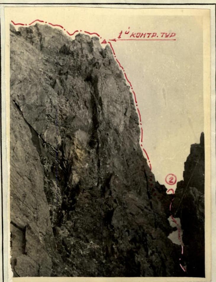
1 rope length of medium rocks, very destroyed, gradually becoming more complex, then 4–5 m of complex rocks with a small number of holds. After a small site, there remains 1 rope length of medium-difficulty rocks to the saddle with a control cairn.
After the 2nd control cairn:
- 2–2.5 rope lengths of rocks on a gentle ridge, where you can move simultaneously;
- then 4–5 rope lengths along rocks of medium difficulty.
On the ridge there are:
- small (2–3 m) walls;
- sharp "knives";
- snow cornices, breaking off to the left.
On this section, there is a control cairn, completely unnecessary, since there can be no other route. After the ridge — a 30–40 m snow-firn ascent with a steepness of 30°, leading to the summit of Комсомола.
Descent from Комсомола by the known route 2А cat. diff. to Комсомольский pass:
The route along the S-3 ridge is technically interesting, filled with various ways of overcoming obstacles. To pass it requires a good knowledge of rock and ice techniques. The route deserves 3Б cat. diff.
Passed by a group consisting of: Rezkin V.P. (leader), Korsunsky G.V., Antipov D.D., Skrinniy L.I. Meeting. Ascent on December 7, 1961. In 1961, the group "A 5 generals" repeated the route: Savel V.I. (leader), Nasonov V.K., Supranov O.V., Shpier D.V. Composition: Savel V.I. (leader.) Group leader: V. Rezkin / V. Rezkin / Davyd / V. Savin /
87
Комсомол
Description of the ascent along the southwest wall.
Peak KOM SOMOL is located in the Malo-Alma-Atinsky spur of the Trans-Ili Alatau in the Tian Shan in the upper reaches of the Kom somolka river, a tributary of the Left Talgar.
The absolute height of the peak KOM SOMOL is 4376 m above sea level. There are five routes to peak KOM SOMOL from 2А cat. diff. to 4Б cat. diff.:
- 2А cat. diff.
- 3А cat. diff.
- 3Б cat. diff.
- 4А cat. diff.
- 4Б cat. diff.
The approach path to peak KOM SOMOL goes through Talgar pass or through Abay pass to Bogdanovich glacier.
General characteristics of the S-W wall
Peak Комсомол
The S-W wall of peak KOM SOMOL has a mark at the beginning of the route (according to the aviation altimeter) — 3770 m above sea level. Thus, the relative height of the wall is about 800 m. Overall steepness — 65–70°.
Wall boundaries:
- On the right — a snowy-ice couloir, starting at the summit;
- On the left — a series of couloirs, separated from the route 2Б cat. diff.
Relief features:
- The lower part of the wall is dissected by shallow couloirs and gutters of a stepped character with very steep smoothed walls;
- The upper part is very steep, in places sheer sections of great length.
In the center of the wall there is a steeply falling, weakly expressed counterfort. This is the most convenient and logical path of ascent along the S-W wall.
The nature of the rocks along the entire wall allows for effective use of piton belay. The granites that make up the wall are quite strong, but heavily smoothed, have a small number of holds, sometimes resembling sheep's foreheads.
Group composition
| Full Name | Rank: | Best ascents |
|---|---|---|
| 1. Mansurov B.Sh. | 1st sports rank | Marble Wall 5А cat. diff., Metallurg 5А cat. diff., Karaulchi-Tau 5А cat. diff. |
| 2. Fedchenko V.P. | 1st sports rank | East. Dombay 5Б cat. diff., Dykh-Tau 5Б cat. diff., Main Dombay-Ulgen 5А cat. diff., Buulgen 5А cat. diff., Ullu-tau-chana 5А cat. diff. |
| 3. Podufalov F.P. | 1st sports rank | Ullu-tau-chana 5А cat. diff., Karaulchitaou 5А cat. diff., Dzhaïlyk 4Б cat. diff., Sullukol 4Б cat. diff., Free Korea 4Б cat. diff. and others. |
| 4. Shalabay V.P. | 1st sports rank | Peak Lenin 5А cat. diff., Uzbekistan 5А cat. diff., Semenov Tian-Shansky — Skryabin 4Б cat. diff. |
| 5. Eshtokin V.I. | 2nd sports rank | Комсомол 4Б cat. diff., Chkalov 4Б cat. diff. |
| 6. Postnikov V.V. | 2nd sports rank | Tuyuk-su horseshoe 4Б cat. diff., Комсомол 4Б cat. diff., Chkalov 4Б cat. diff. |
| Group leader | Mansurov B.Sh. |
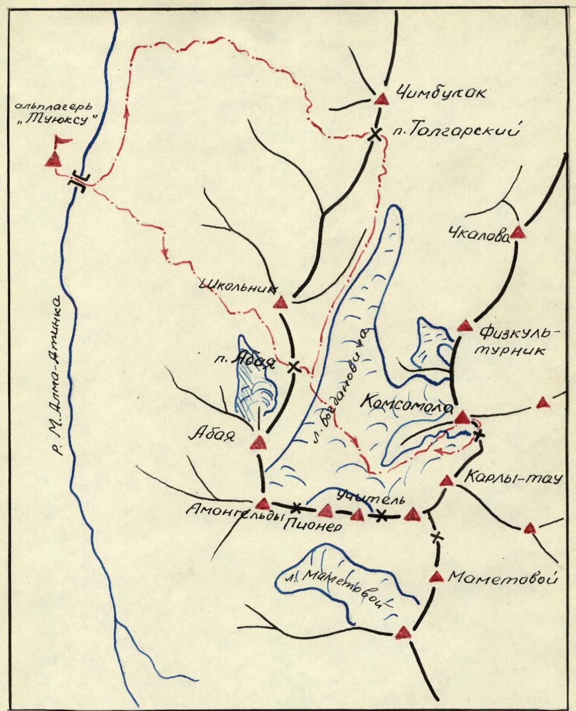
Kartoschema of the Bogdanovich glacier area
Description of the ascent
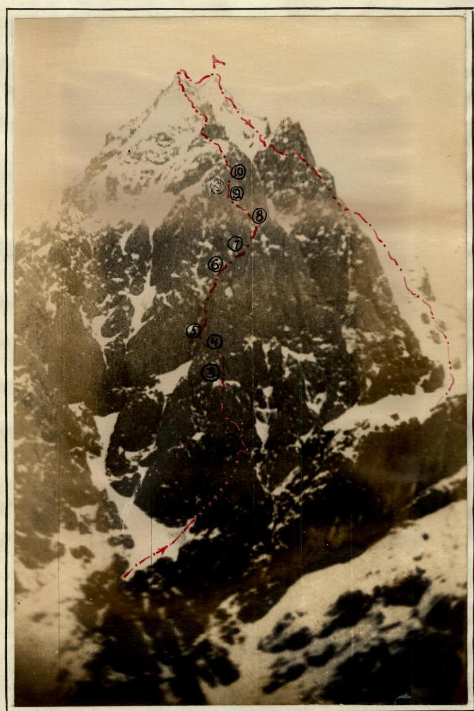
On June 22, 1961, at 5:50 am, the group left the bivouac, located in the immediate vicinity, and at 6:00 am began moving along the route.
1. Section of the route.
Passed along a 60-meter couloir, filled with snow and ice, with an overall steepness of about 50°, to a shallow failure at the base of the "iron" wall. Alternate belay through ledges along the sides of the couloir. See photo #1.
2. Section.
From the failure, a 40-meter wall of the "iron" goes steeply upwards to 80° steepness. Photo #2. Somewhat losing altitude — traverse to the right 5 m and then to the left upwards 25 m along difficult rocks. Belay through pitons! (5 pieces) Further, a difficult, along smoothed rocks without holds, 10-meter traverse to the left with piton protection, and then 15 m straight up along a sheer wall. There are few holds, piton belay, pitons were used as additional points of support! The wall ends with a shallow notch, in which the 1st control cairn is built. After the notch, a wide, with a slight inclination, site of the "iron". A convenient place for a bivouac. Photo #3, #4.
3. Section.
From the "iron" site, the path begins along a sheer wall upwards 30 m, with a subsequent traverse to the left 10–12 m, and further along the cleft 14–15 m upwards to the site. Photo #5, #6, #7. The rocks are difficult, few holds. Pitons were used as artificial points of support. Belay only with pitons!
4. Section.
Along rocks of medium difficulty and further along the gutter, exit to the left into a shallow failure to the base of a 70-meter wall of a ridge type. Here is a small, convenient for belay, site. The entire group can gather on this section. Photo #8.
5. Section.
The 70-meter wall is the key section of the entire route. The overall steepness of the wall is 70–75°. The rocks are heavily smoothed, there are no convenient places for belay. From the failure 20 m upwards, then traverse to the left upwards. On the right — smoothed monolithic rocks, on the left — a sheer wall, going into the couloir. After 15 m of traverse — to the right along the cleft, ascent upwards to the sheer section of the wall. In this section, pitons are used:
- for belay;
- as artificial points of support. Photo #9, #7.
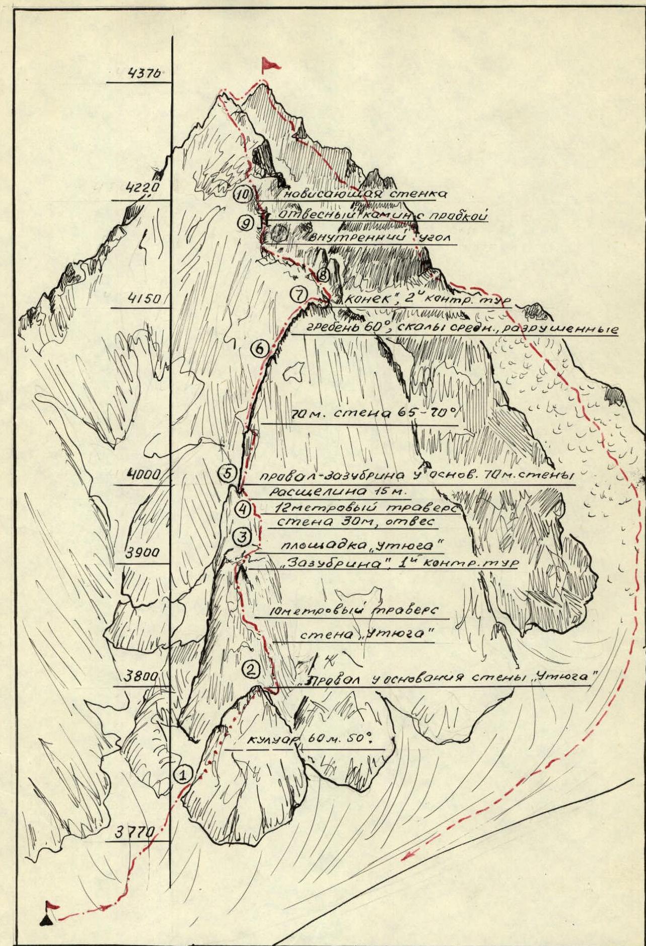
6. Section.
In the upper part, the wall, flattening out, turns into a 60° destroyed ridge. Here, for belay, you can use ledges, there are enough holds, but the passage of this section requires extreme caution, as the thrown stones shoot through the sections of the wall along which the route passes. In the upper part, the ridge becomes sharply gentler. Here, in a shallow failure, before the so-called "ridge" — the 2nd control cairn. Photo #11.
7. Section.
A narrow, sharp ridge — "ridge" — does not represent a particular technical complexity. Passed with alternate belay. Length — 20 m, on both sides sheer walls. Photo #11.
8. Section.
After the "ridge" approach under a heavily notched ridge with smooth sheer walls of "gendarmerie". Photo #12. Having gone to the left upwards along rocks of medium difficulty with a steepness of 50–60° under the "gendarmerie" for 30 m, along the inner corner with smoothed walls, approach to a sheer 12-meter chimney with a plug in the upper part. Piton belay! Very difficult! Behind the exit from the chimney — a convenient site. Photo #13, #14.
9. Section.
From the chimney upwards, exit to the 10th ridge along a very complex overhanging wall 9–10 m. The rocks are smoothed, without holds. The wall is passed with boosting. Photo #15.
10. Section.
Along a gentle, heavily destroyed ridge through 300–350 m, the summit is reached. Descent from the summit is made along the route 2А cat. diff. along the southeast ridge, towards Kom somolsky pass and further to Bogdanovich glacier.
Calculation of the time taken to complete the route
The group left the bivouac at 5:50 am, at 6:00 am began moving along the route and at 5:30 pm reached the summit. The descent along the route 2А cat. diff. took 2 hours. The passage of the route took 13 hours of walking time.
Group conclusions
The participants of the ascent to peak KOM SOMOL along the southwest wall believe that this route is more complex than all the routes of 4Б cat. diff. that they have passed before, and in terms of the saturation with technically complex sections, it is equal to such purely rock routes as:
- Traverse DOMBAY—ULGEN 5А cat. diff.
- BUULGEN along the northeast edge 5А cat. diff. The route is more complex than the routes of 5А cat. diff. on METALLURG and KARAULCHI-TAU, although it is somewhat shorter than the latter, requires participants to ascend:
- good physical and technical training;
- excellent mastery of piton belay. The participants of the ascent believe that the route they have passed along the southwest wall of peak KOM SOMOL corresponds to 5А cat. diff.
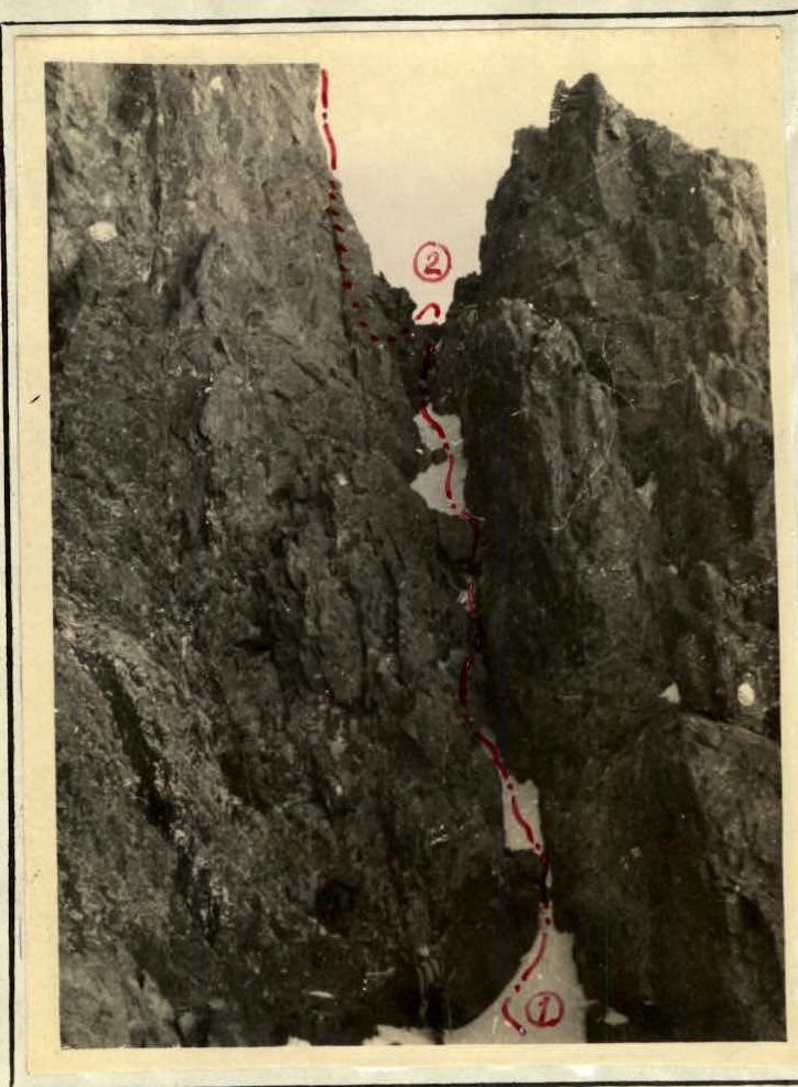
Photo #1. Beginning of the route along the Southwest wall of Комсомола. Couloir — failure.
Photo #2. Wall "Iron". Section failure — site "Iron".