72.55
Zharsay, Southeast Ridge, Cat. 1B
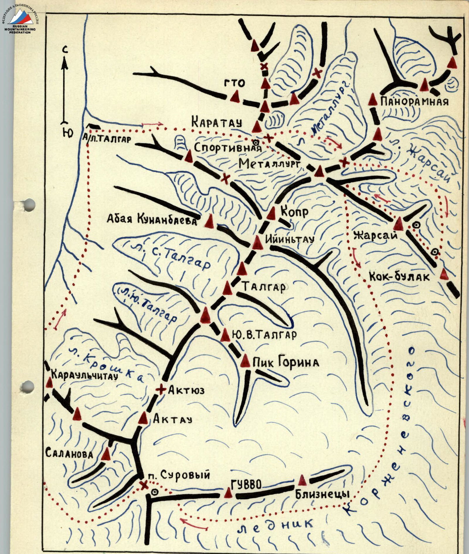
The summit "Zharsay" is located in the main ridge of the Trans-Ili Alatau and is situated southeast of the "Metallurg" peak. The height of the "Zharsay" summit is 4650 m.
Until 1957, there were no ascents to the "Zharsay" summit. The first complete traverse of the "Zharsay" massif was made by a group of instructors from the "Talgar" alpine camp of the "Metallurg" sports society from August 13 to 18. The group consisted of:
- Kelberg A.V. - leader;
- Sorokin S.V.;
- Porokhnya Yu.I.;
- Chernoshchechkina Z.V. - participants.
The path to the foot of the "Zharsay" summit from the "Talgar" alpine camp goes along a trail leading to the training rocks to the east towards the "Ozerny" glacier.
The "Ozerny" glacier should be crossed immediately above the training rocks to reach its right (orographic) bank. Along the right part of the "Ozerny" glacier, one needs to proceed southeast to the foot of the "Taverentava" pass. Then, ascend to the pass via a wide couloir covered with medium scree and snow. The descent from the pass is made towards the "Metallurg" glacier. The snow-ice slope is initially traversed to the left, and then to the right, until reaching the rocky outcrops, from which one can descend to the lateral moraines of the glacier. The "Metallurg" glacier cirque is crossed in an easterly direction, and via firn, and then medium rocks, we reach the saddle of the northeast ridge of the "Metallurg" summit. The descent from the saddle towards the "Zharsay" glacier goes along a steep ice slope. Moving along the right part of the glacier, one needs to go around the lateral ridge.
SCHEME
The route to v. Zharsay (first ascent) along the eastern ridge - the path of the group ○ places for overnight stays, deviating from the main ridge, and then, after 3 hours of walking, approach the foot of the main ridge of the "Zharsay" summit. From the camp to the foot of the "Zharsay" summit - 14-15 hours of walking. Tactically, it is more correct to make an overnight stay under the "Taverentava" pass, and then the next day approach the foot of the summit. The path to the ridge of the "Zharsay" summit is made along a large ice fall towards the lowest point of the ridge.
The length of the ice fall from the foot to the ridge is 1100-1200 m. The steepness of individual sections reaches 65-70°. In several places, the ice fall is intersected by wide crevasses, which sometimes have to be overcome head-on.
The lower part of the ice fall is a steep ice slope of 50-55°. From the very beginning of the path from the foot, crampons should be worn, and hook belays organized. After 200 m of ascent along the ice fall, we approach a small crevasse, the upper edge of which overhangs like a cornice above the cliff. The path initially goes into the crevasse, and then, after cutting several steps inside it, a hook should be driven into the upper part, and using it as a ledge, try to climb to the upper edge of the crevasse.
This place is very difficult due to the negative angle and significant physical strain on the arms with a rather unstable position of the feet in crampons. At the top of the crevasse, a hook belay is organized, ropes are secured, and the remaining participants ascend using the sports method to the belay point. However, more than two people cannot be in this place at the same time (small platform, great steepness), so after receiving the second person, the first in the group must move up and organize the next belay point.
The further path goes along the right part of a narrow ice ridge, the left edge of which:
- ends in a sheer wall;
- terminates in drops.
Moving along the ridge, a hook should be driven every 6-7 m, as the steepness of the slope remains at least 55°.
After 150 m of walking, the relief of the ice fall changes, the path becomes more gentle (up to 15°) and leads to a large crevasse crossing the entire slope from east to west. It is impossible to bypass this crevasse, so one has to descend into it and then exit to the opposite side. The width of the crevasse is 3 m, the depth reaches 15-18 m. However, avalanches, flying over the crevasse, often fill it halfway with snow. As a result, 4-5 m from the upper part of the crevasse, a snow plug forms, which can be used as a foothold. Sitting on the rope, we descend into the crevasse, cut a series of steps on its opposite wall, drive several hooks for more stable positioning, hang carabiners on them, and using them as holds, climb to the opposite bank of the crevasse.
The next section of the path, 500-550 m, is quite simple technically. It represents a not very steep (up to 25°) slope covered with remnants of avalanche deposits, along which it is quite convenient to move. After 50 minutes of walking along this funnel-shaped part of the ice fall, we approach a steep slope, which is limited on the left by steep ice drops with a negative slope, and on the right, it ends in a wall leading to a steep couloir descending directly from the ridge.
One has to move directly "head-on," cutting steps and driving hooks. This section of the path, the steepness of which remains at least 60°, has a length of 230-240 m. This is the most tiring part of the path, requiring significant physical exertion from the climbers.
The last 200 m of the path to the ridge represent an ice-firn slope with small differences in height. Steepness is 40-45°. It should be traversed to the right towards a clearly visible saddle on the ridge.
The ascent to the ridge along the ice fall takes 7-8 hours of work. The group of first ascendants drove 27 ice hooks and cut over 150 steps on this section.
On the saddle, an overnight stay should be organized by descending in a southerly direction from the ridge onto scree convenient for setting up a site.
After the overnight stay, the further path to the summit goes all the time along the ridge. Initially, the ridge is quite gentle, with scree and snow cornices, but after 400 m, the ridge drops sharply by 30 m and then rises in the form of a large gendarme. The descent to the foot of the gendarme is made sitting on the rope to a convenient platform. The ascent to the gendarme, the height of which is 120-130 m, is made along rocky outcrops partially covered with flow ice. The rocks are quite crumbling, partly difficult, and require constant hook belays. On the right, the gendarme is impassable - there it ends in an 800-meter wall on the "Zharsay" glacier. On the left, towards the summit of the gendarme, a very steep (up to 70°) ice groove leads, the path along which is difficult and dangerous. Overcoming the first gendarme takes 2.5-3 hours of working time.
The route of the first ascent of peak Zharsay along the eastern ridge. Most gendarmes are bypassed on the left, six of them are taken "head-on," and only one is bypassed on the right.
From the first gendarme, the descent is made along rocks of medium difficulty, sticking to the right side. Further, along a narrow rocky ridge, we move towards the second gendarme, which is bypassed on the left.
The third gendarme, 15-20 m, is taken "head-on" along rocks of medium difficulty. The descent from it is made using the sports method towards the 4th gendarme, which is bypassed on the left along a narrow ledge.
Along rocks of medium difficulty, we overcome several small rocky elevations on the ridge and approach the gap before a large 120-meter gendarme. The descent into the gap can be organized:
- sitting on the rope;
- using the sports method.
At the top, there is a good ledge around which two ropes can be secured, descended on self-arrest knots, and then pulled out.
The ascent to the gendarme is made "head-on," partially along rocks, partially on ice, in crampons. The steepness of the slope is up to 50°.
The path on the wall of the gendarme goes in zigzags because there are many loose rocks and few places for reliable belays. One has to go out onto the ice and cut steps, belay through ice hooks.
Under the summit tower of the gendarme, there is a good platform where 4-5 people can sit freely. The place is well-protected from the wind. It can be used for:
- rest;
- preparing hot food.
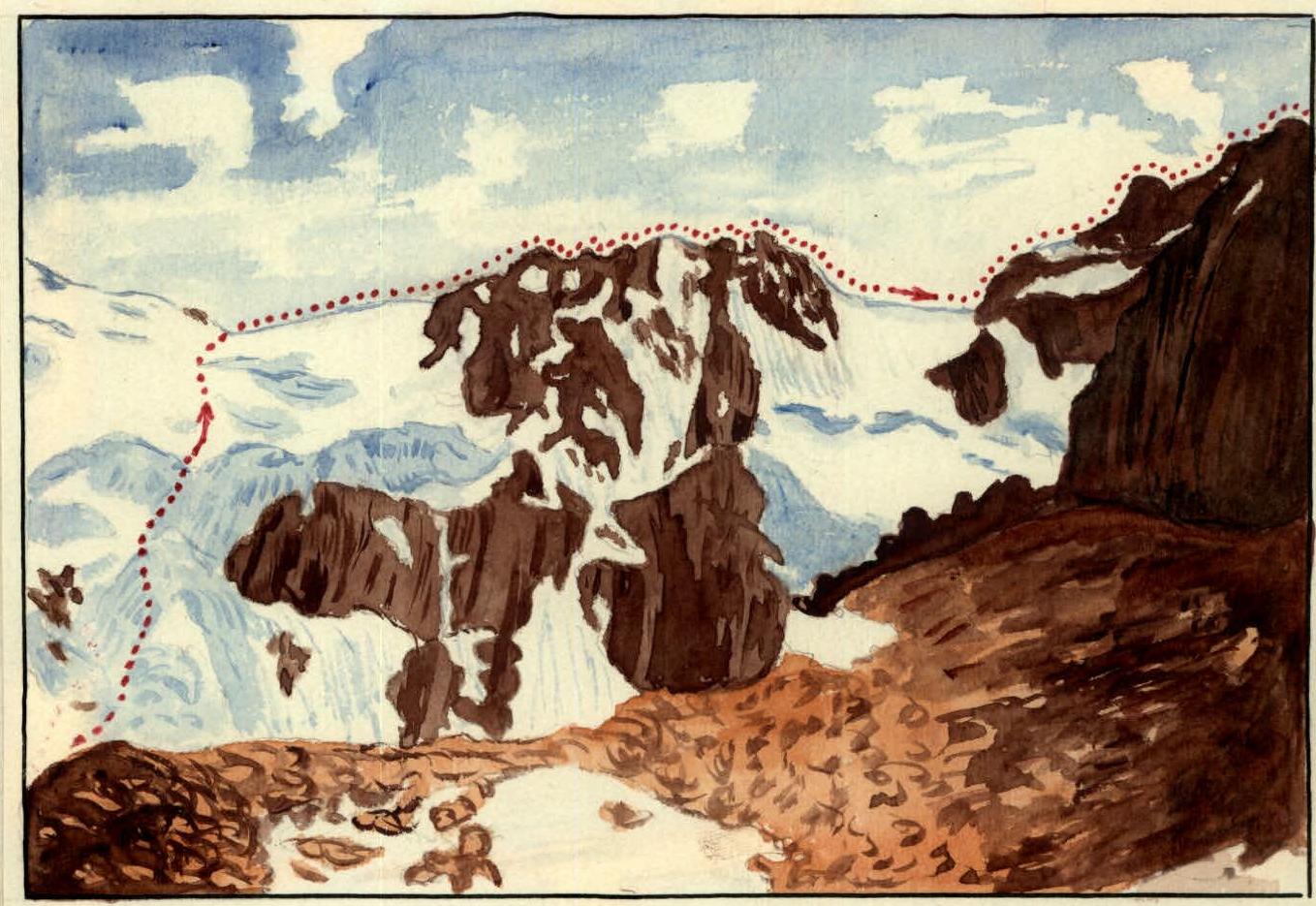
The next section of the path represents a bypass of a pyramidal gendarme. This gendarme ends in smooth walls from the north, west, and east (see photo No. 8).
Only from the west, in the middle part of the gendarme, a:
- narrow crack is visible;
- slightly below it - small bulges in the rock.
Overcoming this section requires special caution and high rock technique. Here are several convenient places for driving hooks; the front phalanges of fingers can fit into the crack, but the position of the feet is not entirely stable, so it is best to overcome this section in light shoes. The most difficult part of the path takes one and a half ropes.
Further, from the gendarme to the southwest, a small counterfort (3 m) departs. From this counterfort, sitting on the rope, one should descend to the lower part of the gendarme and then move towards the foot of the next gendarme covered with rocks frozen into firn and ice.
The ascent to the gendarme is made not to its highest point but slightly lower, to a clearly visible "window." From the "window," we go around this gendarme on the left and descend into a small ice-firn couloir. Along this couloir, one should descend 20-30 m to the south to bypass the next gendarme on the left.
Further, along rocks, partly medium and partly difficult, we reach the saddle between the gendarme and the pre-summit. The ascent to the pre-summit from the saddle is made along rocks covered with flow ice, steep and crumbling. Here, one has to:
- frequently drive hooks;
- cut steps;
- sometimes between rocks - ice steps.
The ascent to the pre-summit takes 1 hour 30 minutes from the saddle. Having descended slightly from the pre-summit, on the scree, an overnight stay can be organized. The time taken by the group from the first overnight stay on the ridge to the second is 10 hours.
The next day:
- Along a not very steep ridge covered with scree, we reach the summit, which is located at the junction of two ridges - the eastern and northeastern.
- Further, the path goes south along the ridge.
- We descend along a steep snow slope into a small depression.
- We ascend 50 m along the snow to the upper point of a small gendarme.
- Moving along the ridge towards the "Bezymyanniy" pass, we overcome several more gendarmes.
The ascent to the gendarmes is not difficult; the descent is made using the sports method:
- once - into a chimney ending in an ice groove;
- another time - onto a steep snow slope.
The last gendarme on the ridge is bypassed on the right; with careful hook protection, it is necessary to exit the upper part of a small chimney, at the bottom of which is flow ice. Here, one has to cut steps and drive an ice hook. The further path along the ridge is simple - medium scree.
We move to the "Bezymyanniy" pass, from it descend along a snowy slope to the Korzhenevskogo glacier, and walk along the glacier in the direction of the "Suroviy" pass. After 6-7 hours of walking, we approach the foot of the pass, where the fourth overnight stay should be organized. The path from the "Zharsay" summit to the "Bezymyanniy" pass takes 2.5-3 hours.
The subsequent path goes:
- through the "Suroviy" pass;
- onto the Shokalskogo glacier;
- along its right lateral moraine - to the "Talgar" alpine camp.
The entire traverse of the "Zharsay" massif (with approaches) takes a full four days. In terms of physical load and technical work, it is more complicated than the traverse of the Talgar massif, more diverse, and significantly more difficult than the traverse of the Chekist-Salanova-Aktau peaks.
Throughout the entire route, the group drove 35 ice and 28 rock hooks.
Considering all the above, the group evaluates the complete traverse of the "Zharsay" massif with an ascent along the ice fall to the eastern ridge and descent to the "Bezymyanniy" pass as a Cat. 4B route.
The description was compiled by Master of Sports of the USSR (A. Kelberg) with an approximate scheme of the route.

