gorge
- v. Chernaya 1915 m, via the cornices of the Northern wall, 2004 (first ascent) difficulty category
- Team leader: Devi M.M.
- Western Sayan, Ergaki mountain range, Taygishonok river
- Section in the classification
22nd Open Championship
of Russia in Alpinism
2004
Rock Climbing Class
REPORT
on the first ascent by the team of the Federation of Alpinism and Rock Climbing of Sverdlovsk Region (FAiS Sverdlovsk Region) on v. Chernaya 1915 m via the cornices of the Northern wall. 6B category difficulty.
Addresses:
620041, Yekaterinburg, Ural'skaya st. 58/1-142, YArunov Anatoliy Anatol'evich, tel. (343) 333-16-76, yarunov@e-tel.ru, Yekaterinburg, 2004
Report on the Ascent to v. Chernaya
Table of Contents
- Ascent Passport … 3
- Route Description by Sections … 4
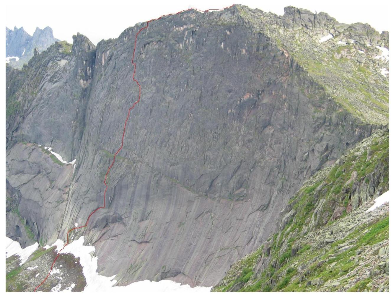
- General Photo of the Summit … 6
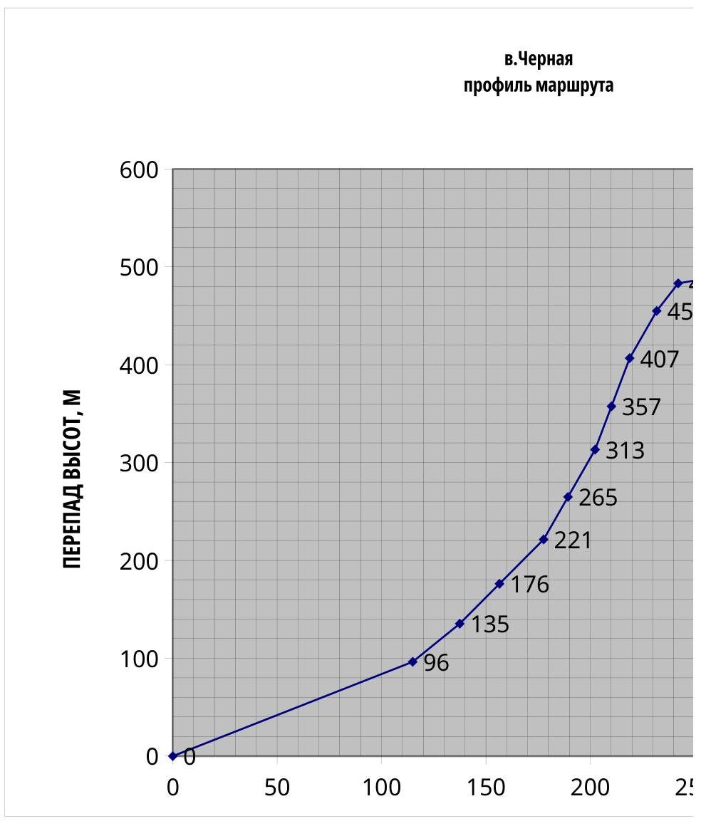
- Photo of the Wall Profile … 7
- Drawn Profile of the Route … 8
- Panorama of the Area … 9
- Map-Scheme of the Area with Approach Options 10
- Ascent Schedule … 11
- UIAA Scheme … 12
- Technical Photo of the Route … 13
- Photographs from the Route … 14
11.1. Section R1–R2 (sickle) … 14
1. Ascent Passport
Area — Western Sayan, Ergaki ridge Peak — Chernaya 1915 m via the cornices of the N. Wall Proposed — 6A category difficulty, first ascent. Route character — rock climbing
Route Characteristics:
height difference of the route — 552 m. wall section height difference — 390 m. route length — about 760 m. wall section length — 410 m. average steepness of the route — 64°. average steepness of the wall section — 75°. length of sections with 6 category difficulty — 350 m, 5 category difficulty — 50 m.
Left on the route: pitons — 0; chocks — 0.
Pitons used on the route:
- stationary bolt pitons — 0
- removable bolt pitons — 5 (8 mm).
Total protection used — about 200, including skyhooks — 10.
Number of:
- climbing hours — 19
- days — 1
- bivouacs — 0.
Team leader — Devi Mikhail Marenglenovich, ZSM
Team members:
- YArunov Anatoliy Anatol'evich, MS
- Bobrov Igor' Borisovich, 1st sports category
- Borich Mikhail Aleksandrovich, 1st sports category
Team coaches:
- Devi Mikhail Marenglenovich, ZSM
- YArunov Anatoliy Anatol'evich, MS
Date of Ascent:
start of ascent — July 9, 2004, reaching the summit — July 9, 2004, return — July 10, 2004.
Organization: FAiS Sverdlovsk Region.
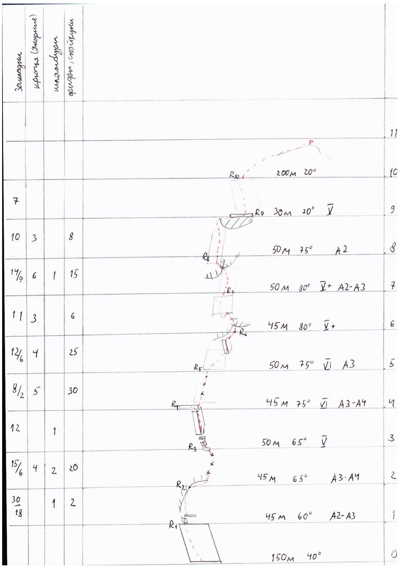
2. Route Description by Sections
Section R0–R1: From Chyornoe lake upwards along an inclined plate 30–40°. 150 m. 1st category difficulty. Approach to the wall below the "sickle".
Section R1–R2. Length 45 m. Along an inclined shelf and an internal corner, approach to a shelf below the first cornice in the shape of a sickle (climbing 4th category difficulty, 15 m). Then upwards to the right along the sickle.
Complex artificial climbing (A3):
- wet and dirty crack
- unreliable protection
- good placement for friends, full set required (from smallest to largest)
Hanging belay station on a bolt in the center of the horizontal part of the sickle.
Section R2–R3. Length 45 m. Traverse under the sickle to the right until the start of a thin vertical crack (10 m, artificial climbing A2–A3, friends, skyhooks). For protection, a bolt was driven.
Further upwards along a deep crack. In the lower part of the crack, the wall is weakly overhanging. In the upper part, the wall is close to vertical, but the crack is strongly inclined first to the right, then to the left, which significantly complicates its passage.
Artificial climbing on flakes (A3), protection on anchor pitons, after 15 m another intermediate bolt.
Exit to an inclined grassy shelf, where a station is organized.
Section 3–4. Length 50 m.
- Upwards along slippery, dirty, grassy shelves to an internal corner
- Along a dirty, wet internal corner, climbing to a large grassy shelf
No obvious holds or cracks, complex "balance" climbing, difficult to place intermediate protection, rocks are wet. Station on a bolt. Space for a lying bivouac.
Section 4–5. Length 45 m. Upwards along a series of deep cracks. Artificial climbing on flakes (A3–A4), occasional short sections (3–5 m) of free climbing (6th category difficulty). Station on anchor pitons.
Section R5–R6. Length 50 m. Upwards to the left along a series of cracks with a general direction under the left part of the cornice. Artificial climbing A3. Below the cornice, 10 m away — a ruined internal corner. Passed by climbing — "wedging yourself inside the crack and jamming with everything possible". After the internal corner — again artificial climbing on flakes with a direction to the right of the main overhang through the cornice. Hanging station to the right of the large cornice.
Section R6–R7. Length 45 m. Initially, 10 m of artificial climbing on flakes through a small overhang. Then climbing along a series of inclined shelves (5–6th category difficulty). After another 10 m, the shelves end, a small pendulum move to the left (3–4 m), and then along shelves upwards to the left. Climbing is tense:
- cracks overgrown with grass,
- difficult to organize intermediate protection,
- relief is "poor",
- some sections require climbing "on balance" without holds under the hands.
Section R7–R8. Length 50 m.
- 20 m upwards to the right, combining artificial climbing A2–A3 (flakes, stoppers, skyhooks) and climbing (6th category difficulty)
- Approach under a large cornice to the place of its fracture
- The cornice is traversed by a traverse along a slab to the left — upwards on skyhooks (3–5 m), for protection, a bolt was driven at the start of the slab
- Exit to the cornice
- Above the cornice, artificial climbing along a crack (flakes, anchor pitons, occasional stoppers)
- Station is hanging, on a bolt
Section 8–9. Length 50 m. Upwards, partly climbing (4–5th category difficulty, in wet conditions 6th category difficulty), partly artificial climbing (A2). Bypass of an overhanging boulder to the left and then traverse to the right to a wide shelf.
Climbing is complex, rocks are covered with thin moss, which in rainy conditions creates ideal lubrication.
Section R9–R10. Length 30 m. Along an internal corner upwards to the exit to the ridge.
Wide cracks, climbing (5th category difficulty, in wet conditions 6th category difficulty). In wet conditions, climbing is complex.
Section R10–R11
- Length about 200 m
- Along a simple ridge, exit to the summit
Descent direction:
- Through the summit along the ridge towards the Tuman'nyy pass
| Section | Section Length, m | Section Steepness, deg. | Height Difference, m | Base, m | Difficulty | Remarks |
|---|---|---|---|---|---|---|
| 0 | 0 | |||||
| "0-1" | 150 | 40 | 96 | 115 | ||
| "1-2" | 45 | 60 | 135 | 137 | А2–А3 | sickle |
| "2-3" | 45 | 65 | 176 | 157 | А3–А4 | |
| exit | ||||||
| "3-4" | 50 | 65 | 221 | 178 | to | |
| shelf | ||||||
| :--: | :--: | :--: | :--: | :--: | :--: | :--: |
| "4-5" | 45 | 75 | 265 | 189 | А3–А4 | |
| "5-6" | 50 | 75 | 313 | 202 | cornice | |
| overhang | ||||||
| "6-7" | 45 | 80 | 357 | 210 | ing | |
| "7-8" | 50 | 80 | 407 | 219 | А2–А3 | cornice |
| "8-9" | 50 | 75 | 455 | 232 | A2 | |
| "9-10" | 30 | 70 | 483 | 242 | cornice | |
| ridge | ||||||
| to | ||||||
| "10-11" | 200 | 20 | 552 | 430 | summit | |
| Total | 760 | 552 | 430 |
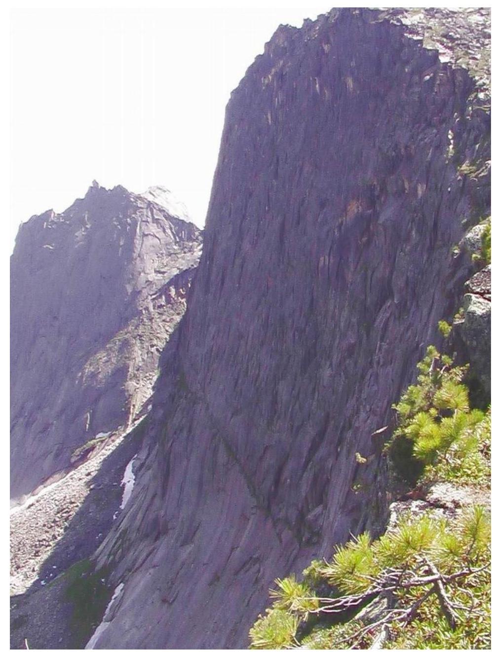
- General Photo of the Summit. View from the
Tuman'nyy pass
- Photo of the Wall
Profile
- Drawn Profile of the
Route
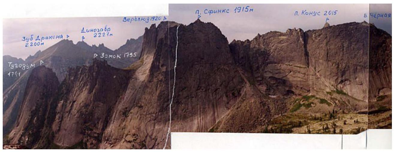
- Panorama of the Area. Photo taken from the report on the first ascent by alpinists from
Krasnoyarsk Kray Sport Committee consisting of Balezin V.V., Dmitriyenko E.V., Tsyganov D.V. (August 26, 2002, Sphinx peak)
Note: on the photo, the names are incorrectly indicated: during the championship, at a general meeting of judges and athletes, the celebration was held, and the peaks were renamed:
- P. Sphinx 1915 m — is actually peak Orёл 1915 m.
- P. Verblud 1920 m — is actually peak Sphinx 1920 m.

-
Map-Scheme of the Area with Approach Options. Recommended approach — left variant. From Tormazakovskiy bridge to Raduzhnoe lake (1.5 hours), then along the trail to the left upwards to Spyashchiy Sayan, through Volosy pass (2 hours), descent to Lazurnoe lake and further to Tuman'nyy pass (2 hours), descent from which leads to Chyornoe lake — ABC camp.
Group Movement Schedule
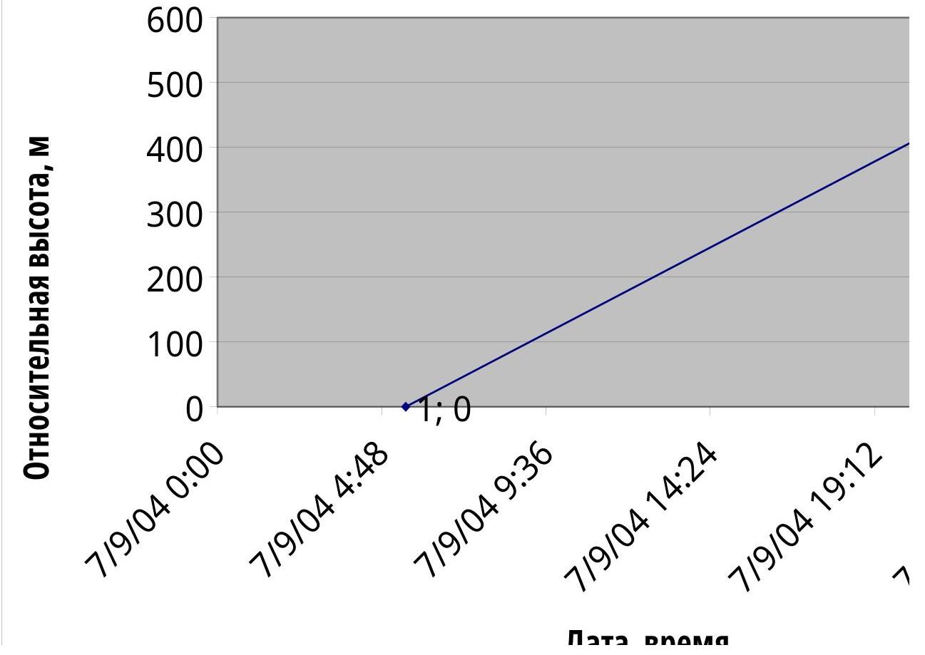
- Ascent
Schedule
- UIAA
Scheme
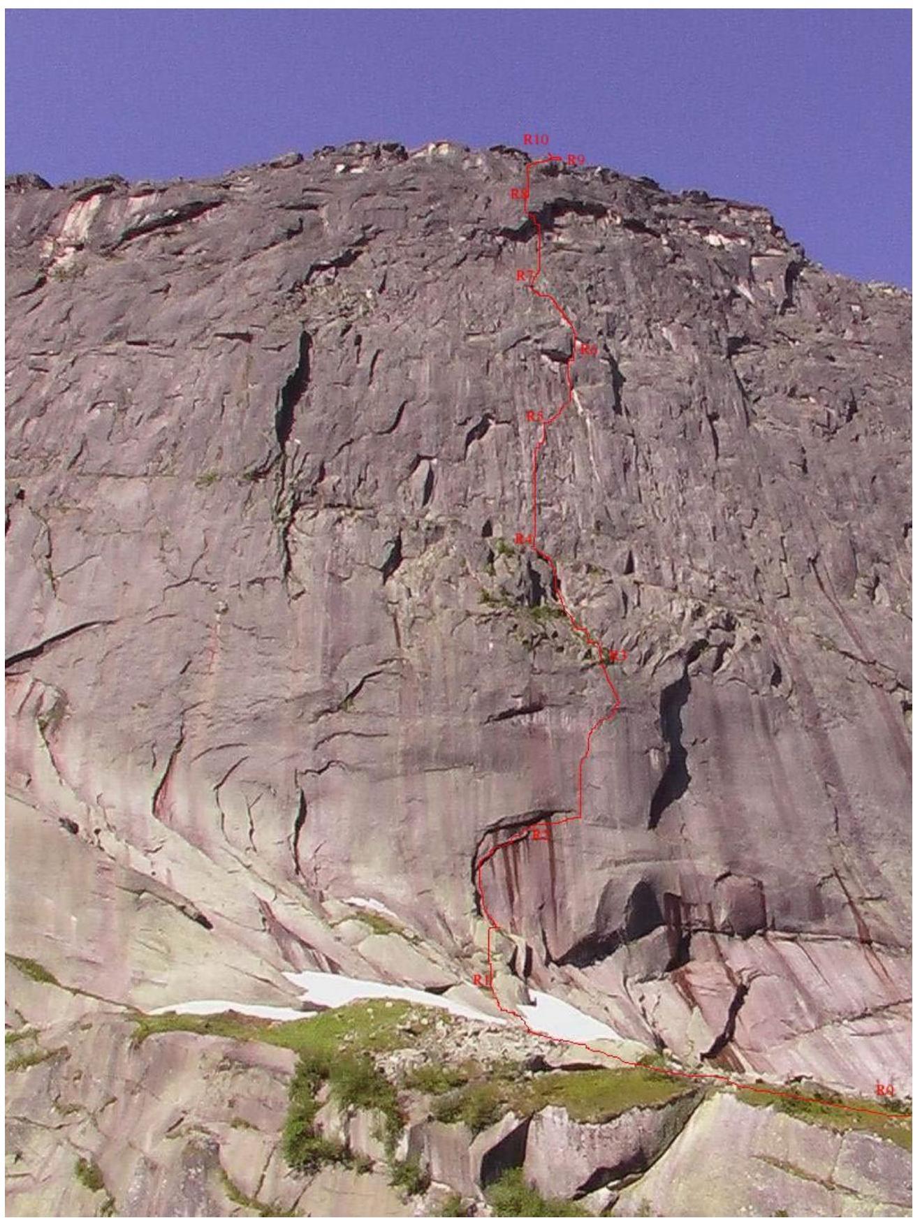
- Technical Photo of the
Route
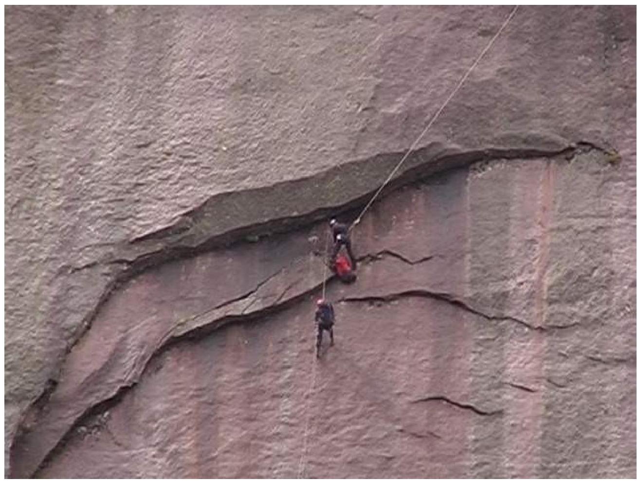
11.1. Chernaya, "sickle". Station R2 (under competition conditions, the team had no opportunity to take photos on the route)