-
Mt. Orel 1915 m, center of North wall, 2004 (first ascent) diff. cat.
-
Leader: Davy M.M., Master of Sport
-
Western Sayan, Ergaki mountain range, Taygishonok river gorge
-
Section in Classification
22nd Open Russian Championship in Alpinism 2004
Rock Climbing Class
Report
On the first ascent by the team from the Federation of Alpinism and Rock Climbing of Sverdlovsk region (FAiS Sverdlovsk region) on Mt. Orel 1915 m via the center of the north wall. 6B category of difficulty.
Addresses:
620041, Yekaterinburg, Ural'skaya st. 58/1-142, Anatoly YArunov, phone (343) 333-16-76, yarunov@etel.ru Yekaterinburg 2004
Report on the Ascent of Mt. Orel
Content
- Ascent Passport — 3
- Route Description by Sections — 4
- General Photo of the Summit — 6
- Photo of the Wall Profile — 7
- Drawn Route Profile — 8
- Panorama of the Area — 9
- Map-Scheme of the Area with Approach Options — 10
- Ascent Schedule — 11
- UIAA Scheme — 12
- Technical Photo of the Route — 13
- Photos from the Route — 14 11.1. Photo of the wall from ABC camp with the team's route — 14
1. Ascent Passport
Area — Western Sayan, Ergaki ridge, Taygishonok river gorge
Peak — Orel 1915 m, via center of N wall
Proposed — 6A category of difficulty, first ascent.
Route character — rock climbing
Route characteristics:
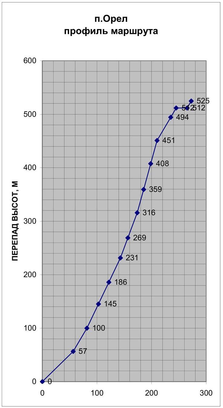
- Height difference of the route — 525 m
- Height difference of the wall section — 512 m
- Route length — approximately 610 m
- Wall section length — 585 m
- Average steepness of the route — 65°
- Average steepness of the wall section — 70°
- Length of sections with 6 category of difficulty — 450 m, 5 category of difficulty — 50 m
Left on the route: pitons — 0; protection devices — 0. Pitons used on the route:
- stationary bolted pitons — 0
- removable bolted pitons — 12 (8 mm).
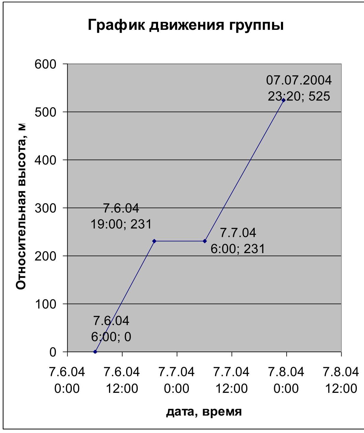
Total protection devices used — approximately 300, including skyhooks — 40. Climbing time — 29 hours, days — 2. Number of bivouacs — 1 lying on a grassy ledge.
Leader — Davy Mikhail Marenglenovich, Honored Master of Sport
Team members:
- YArunov Anatoly Anatolyevich, Master of Sport
- Bobrov Igor Borisovich, 1st sports category
- Borich Mikhail Alexandrovich, 1st sports category
Team coaches:
- Davy Mikhail Marenglenovich, Honored Master of Sport
- YArunov Anatoly Anatolyevich, Master of Sport
Departure date:
for the ascent — July 6, 2004, to the summit — July 7, 2004, return — July 8, 2004.
Organization: FAiS Sverdlovsk region.
2. Route Description by Sections
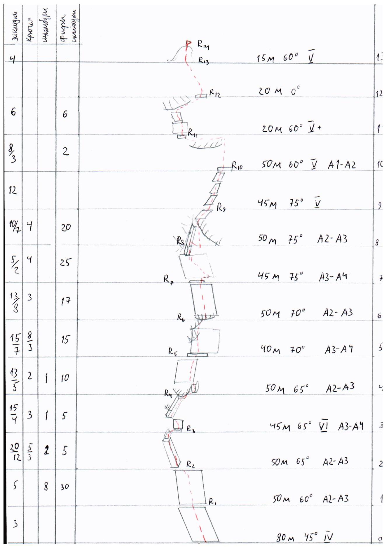
Section R0–R1. Length 80 m. Monolithic smooth slabs, complete absence of cracks. Steepness gradually increases from 40 to 50°. Friction climbing (4). Reception point is located on a pronounced white spot.
Section R1–R2. Length 50 m. Monolithic smooth slabs without cracks or obvious holds. Steepness 60°. AID on skyhooks (A2), protection via bolts. Belay station on a bolt.
Section R2–R3. Length 50 m. Left and up via a crack along a slab, exit onto a ledge above the slab. Belay station on a bolt. AID A2–A3.
Section R3–R4. Length 45 m. Up 5 m via climbing to a micro-ledge, then 5 m left-up via a "mirror" on rock pitons to an inclined ledge. Along it 30–35 m with a general direction right-up through a series of small cornices. Climbing sections (6) combined with AID (A3–A4). All cracks are dirty, filled with grass and earth. Intermediate protection points are unreliable. Wet grass greatly complicates climbing. Reception point on a bolt under a cornice. "Hanging" belay station.
Section R4–R5. Length 50 m. Exit through a cornice on the right via an overhanging internal corner. After the cornice, up via a series of blind cracks (AID on micro-protection, A2–A3) to an exit onto a ledge. Reception point on a bolt. 20 m to the right — bivouac site. From the bivouac site, the further direction of the route is clearly visible.
Section R5–R6. Length 40 m. Complex AID (A3–A4) via a series of open cracks with a general direction up through a number of small cornices. Belay station is hanging, on anchor pitons.
Section R6–R7. Length 50 m. Up via a series of blind (micro-protection) and open (stoppers, friends) cracks to a small ledge. AID A2–A3.
Section R7–R8. Length 45 m. First, 3 m traverse right via a horizontal crack on friends to a blind crack with a direction left-up. Then via the crack, AID on micro-protection (A3–A4). Protection on pitons (anchor and chock stones). Belay station is hanging, in an internal corner.
Section R8–R9. Length 50 m. From the belay station, a 10 m pendulum right to a blind vertical crack. Via it, exit into a gap between cornices. Then right and up via inclined cracks overgrown with grass. AID A2–A3. Belay station is hanging, on anchor pitons.
Section R9–R10. Length 45 m. Up and right via climbing (5) via a series of small inclined ledges to a large ledge. Space for a semi-sitting bivouac. Climbing is complex due to:
- wet rocks,
- cracks filled with wet grass.
Section R10–R11. Length 50 m. Climbing up to an approach under a large cornice (4–5). The cornice is bypassed on the right via a crack (AID A1–A2, friends, large stoppers). Then along the ledge, traverse left (climbing 3).
Section R11–R12. Length 20 m. Via a blind crack, AID on micro-protection up 3–4 m to an inclined sloping ledge, then left-up via "balance" climbing — approach under an overhang. Under the overhang, a sloping ledge — on hands, traverse right. Exit onto a ridge.
Section R12–R13. Via a simple ridge, approach under the summit tower.
Section R13–R14 — Summit Tower. Wide cracks, free climbing (5).
Descent direction: via the ridge into the couloir between Mt. Orel and Mt. Chyornaia.
| Section | Length, m | Steepness, ° | Height difference, m | Base, m | Difficulty | Notes |
|---|---|---|---|---|---|---|
| R0–R1 | 80 | 45 | 57 | 57 | ||
| R1–R2 | 50 | 60 | 100 | 82 | A2–A3 | "mirror" |
| R2–R3 | 50 | 65 | 145 | 103 | A2–A3 | |
| R3–R4 | 45 | 65 | 186 | 122 | A3–A4 | |
| R4–R5 | 50 | 65 | 231 | 143 | A2–A3 | Exit onto a ledge. Bivouac |
| R5–R6 | 40 | 70 | 269 | 157 | A3–A4 | |
| R6–R7 | 50 | 70 | 316 | 174 | A2–A3 | |
| R7–R8 | 45 | 75 | 359 | 185 | A3–A4 | |
| R8–R9 | 50 | 75 | 408 | 198 | A2–A3 | pendulum |
| R9–R10 | 45 | 75 | 451 | 210 | ||
| R10–R11 | 50 | 60 | 494 | 235 | A1–A2 | |
| R11–R12 | 20 | 60 | 512 | 245 | Exit onto a ridge | |
| R12–R13 | 20 | 0 | 512 | 265 | Along ridge | |
| R13–R14 | 15 | 60 | 525 | 273 | Summit Tower | |
| Total | 610 | 525 | 273 |
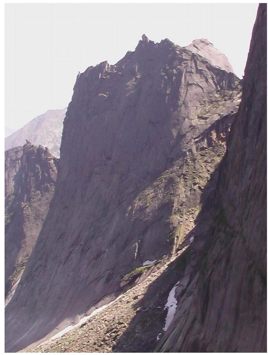 3. General Photo of the Summit (route 9). Provided by the judging panel.
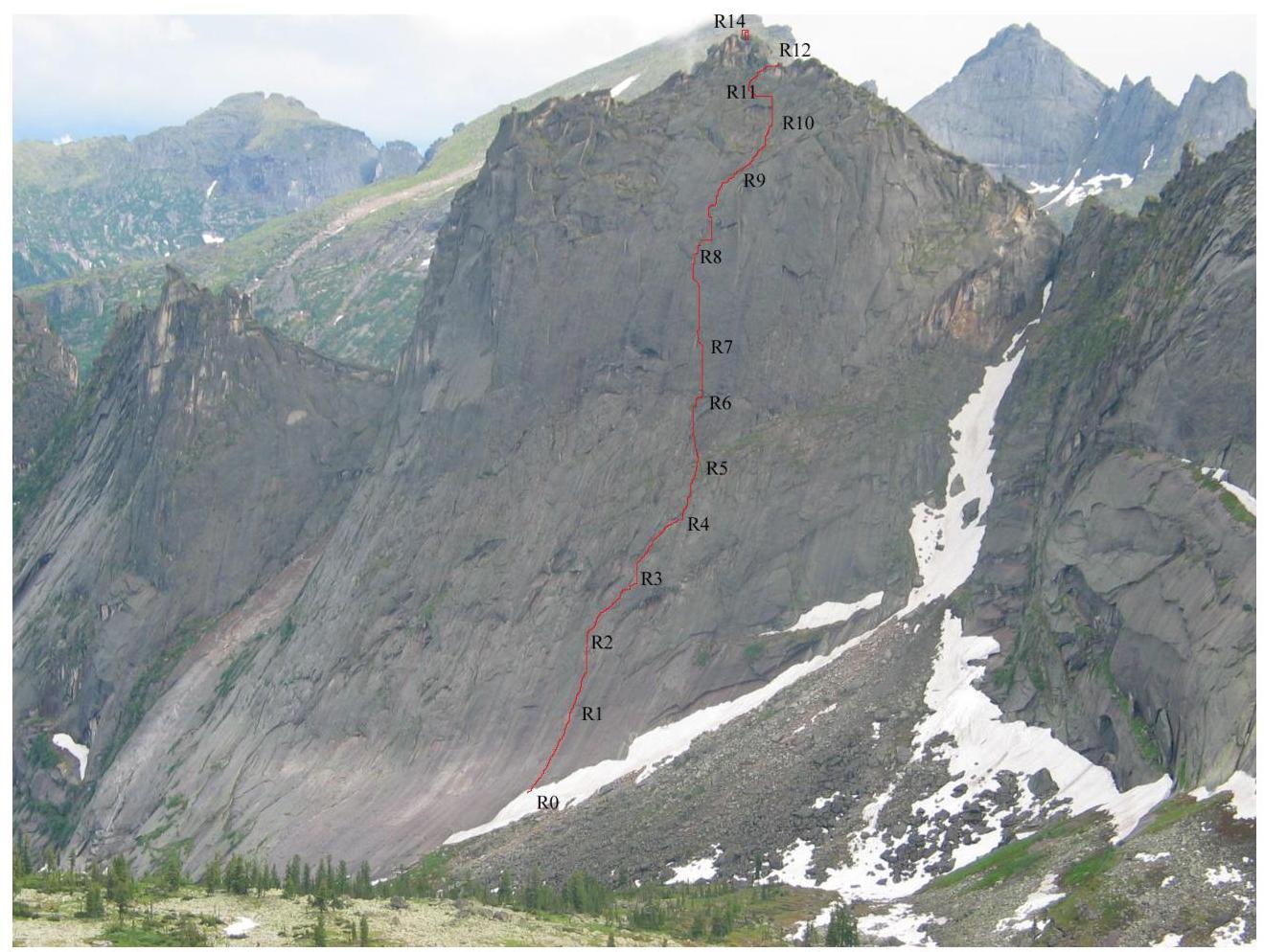
 4. Photo of the Wall Profile
 5. Drawn Route Profile
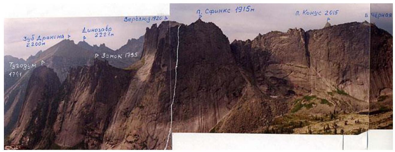
 6. Panorama of the Area. Photo taken from a report on the first ascent by climbers from the Krasnoyarsk Kraisportkomitet, team members: Bazilezin V.V., Dmitrienko E.V., Tsyganov D.V. (August 26, 2002, Mt. Sphinx).
Note: the photo incorrectly indicates the names: the decision to rename was made at a general meeting of judges and athletes of the Championship. Mt. Sphinx 1915 m is Mt. Orel 1915 m. Mt. Verblud 1920 m is Mt. Sphinx 1920 m.
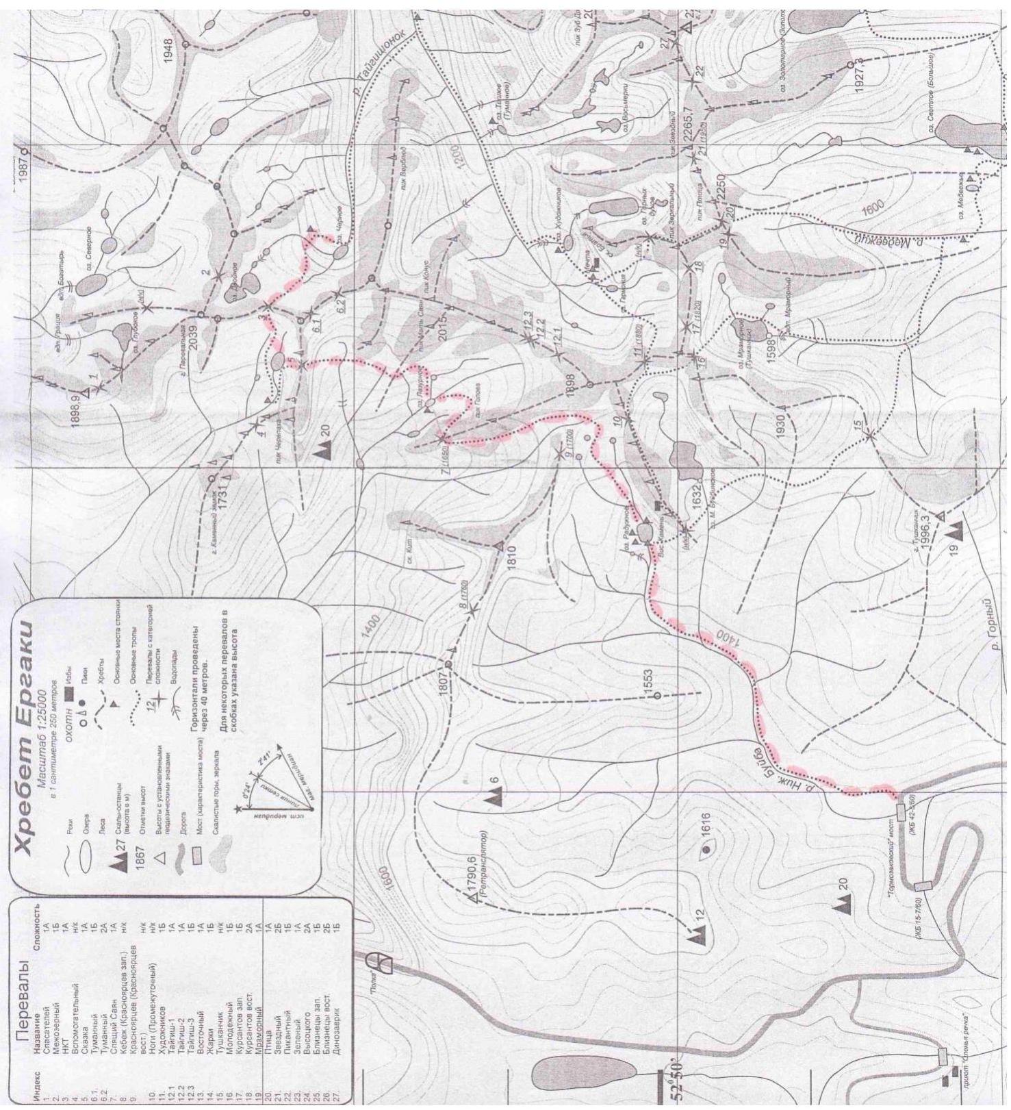
 7. Map-Scheme of the Area with Approach Options. Recommended approach — left variant. From
Tormazakovsky bridge to Raduzhnoe lake (1.5 hours), then via a trail left-up to the sleeping Sayan, through "Volosy" pass (2 hours), descent to Lazure lake and further to "Tumanny" pass (2 hours), descent from which leads to Chyornoe lake — ABC camp.
7. Map-Scheme of the Area with Approach Options. Recommended approach — left variant. From
Tormazakovsky bridge to Raduzhnoe lake (1.5 hours), then via a trail left-up to the sleeping Sayan, through "Volosy" pass (2 hours), descent to Lazure lake and further to "Tumanny" pass (2 hours), descent from which leads to Chyornoe lake — ABC camp.
 8. Ascent Schedule
 9. UIAA Scheme
10. Technical Photo of the Route
9. UIAA Scheme
10. Technical Photo of the Route
 11. Photos from the Route
Photo of the wall from ABC camp with the team's route (In the conditions of the in-person Championship, the team did not have the opportunity to take photos on the route)