REPORT
on the ascent (first ascent) of p. Zvezdniy via the right part of the South wall (proposed 5A(5B) category of difficulty)
I suggest considering it as 5B for the group. Balezin V. V.
Participants:
- Smaikina S.V.
- Kovaleva A.V.
- Coach Temerev I.M.
ASCENT PASSPORT
- Region: Western Sayan, Ergaki ridge, section number according to the 2008 classification table – 6.2
- Peak: Zvezdniy 2265 m, via the right part of the S wall
- First ascent. Proposed 5A–5B category of difficulty.
- Route type: rock
- Route height difference: 300 m (according to altimeter)
Route length: 440 m. Section lengths:
- V category of difficulty — 80 m
- VI category of difficulty — 105 m. Average steepness:
- entire route — 61°
- main part of the route — 87°
- Pitons left on the route: total 0
Used on the route:
- bolt pitons: 0
- rock pitons: 5, including
- anchor pitons: 3
- artificial points of support (AIDS): 3
- chocks, friends: 42, including AIDS – 31
Total artificial points of support (AIDS) used: 43, including fifi hooks and skyhooks
- Team's travel time:
8 hours 40 minutes, 1 day
- Team composition: Smaikina Svetlana Vladimirovna, Candidate Master of Sports
Kovaleva Anastasia Viktorovna, Candidate Master of Sports
- Team coach: Temerev Ivan Mikhailovich, Candidate Master of Sports
- Departure for the route: 10:00 July 21, 2009
Reached the summit: 18:40 July 21, 2009. Returned to Base Camp: 22:00 July 21, 2009.
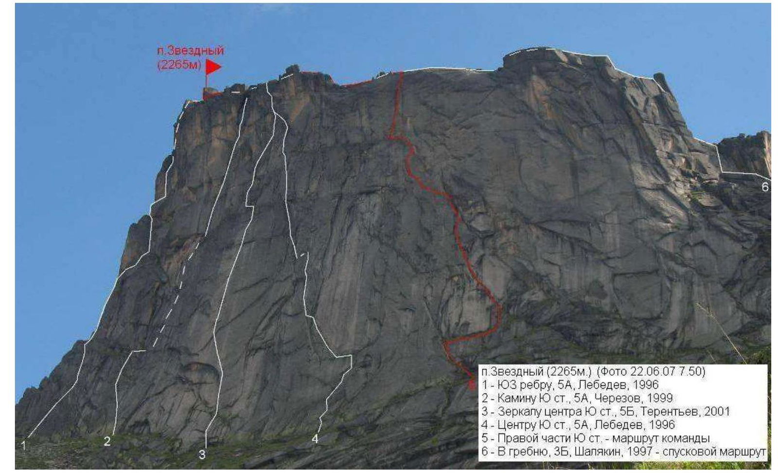
p. Zvezdniy (2265 m) (Photo 22.06.07 7:50)
1 — SW edge, 5A, Lebedev, 1996; 2 — S wall chimney, 5A, Cherezov, 1999; 3 — S wall center mirror, 5B, Terentyev, 2001; 4 — S wall center, 5A, Lebedev, 1996; 5 — Right part of S wall — team's route; 6 — E ridge, 3B, Shalyakin, 1997 — descent route
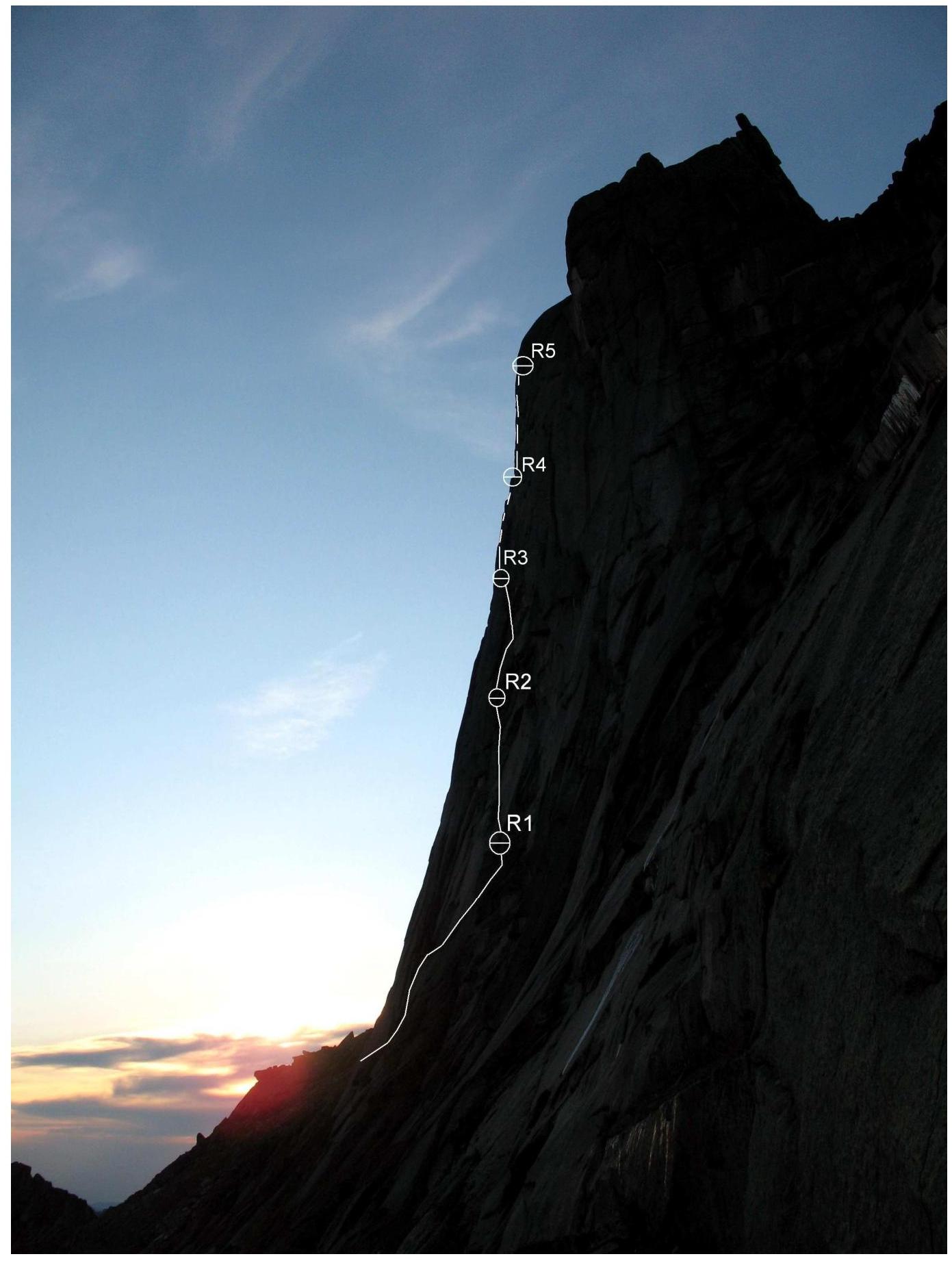
p. Zvezdniy. South wall. Route profile from the right (photo taken from the start of the route via E ridge, 3B category of difficulty, Shalyakin)

p. Zvezdniy. Hand-drawn profile of the route via the right part of the South wall
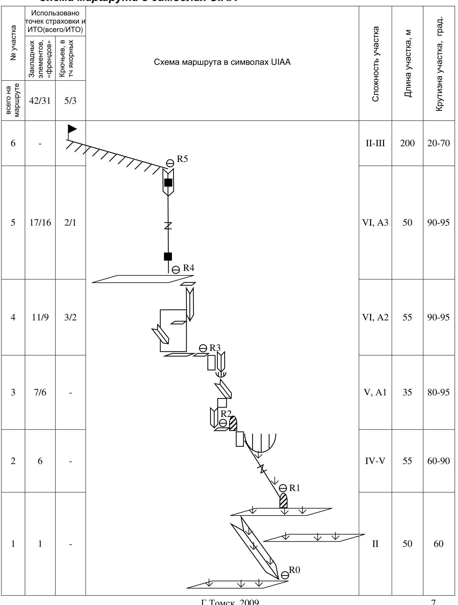
Tomsk, 2009. Route scheme in UIAA symbols
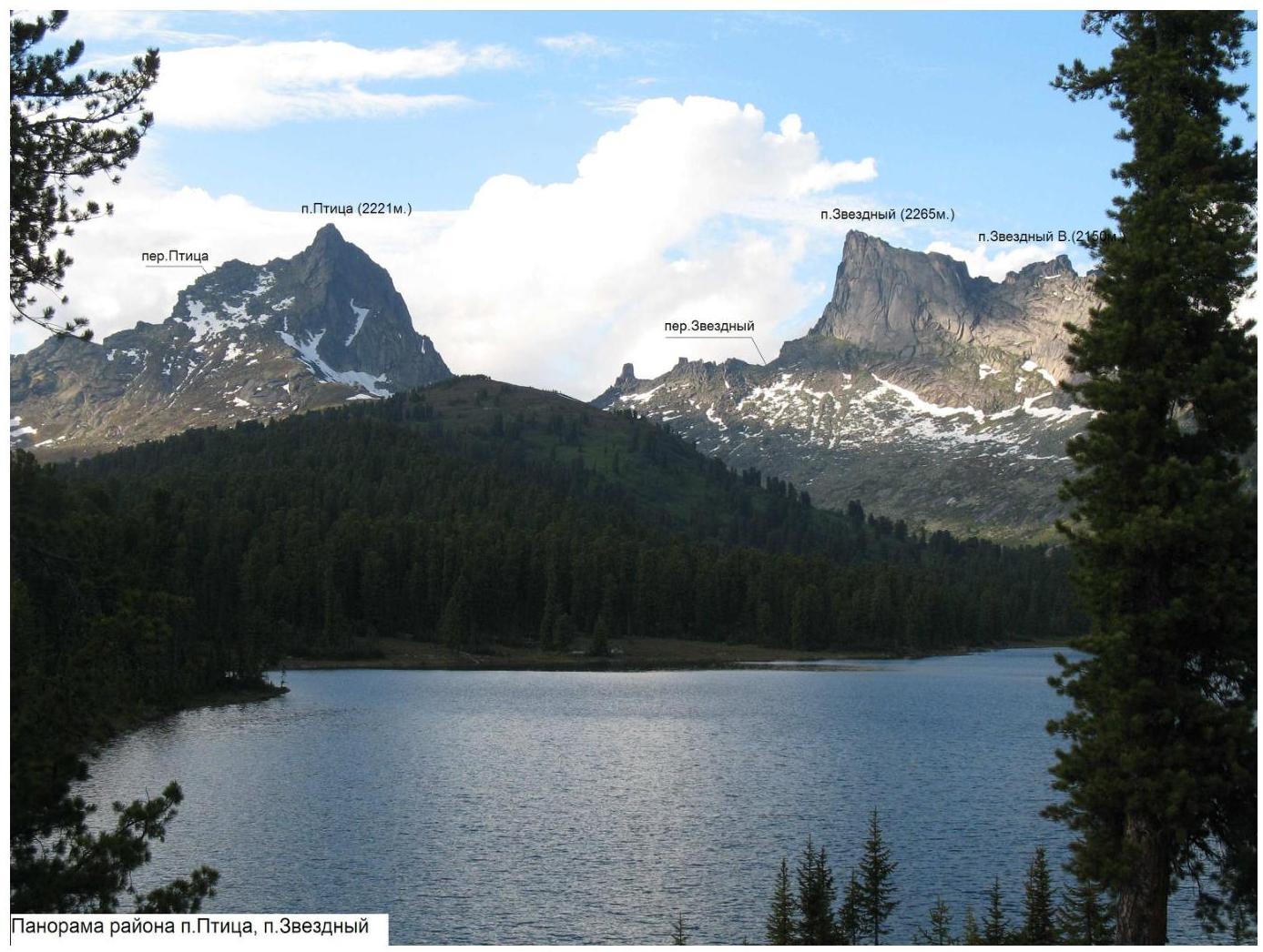
Panorama of the area p. Ptitsa, p. Zvezdniy
ROUTE DESCRIPTION BY SECTIONS
Approach to the route via overgrown grassy broad ledges from left to right. Insurance is desirable in wet weather.
R0–R1 – Overgrown grassy inner corner-crack left of a series of large grassy ledges.
- Traverse right along the upper ledge 10–12 m
- Ascend via grassy ledges to a spall
R1 belay station on the spall. 50 m, II–III
R1–R2 – Up and left via a crack heavily overgrown with grass, steepness up to 90° in places. A cornice (overhanging slab) is bypassed on the left via a small wall. Exit onto a ledge behind the spall. Convenient R2 belay station. 50–55 m, IV–V
R2–R3 — Up via the inner corner, transition via the wall (diagonal crack) to the right into another inner corner. Via it under a cornice 10–12 m. Bypass the cornice on the left. Further via the inner corner with a crack, or left via the wall — exit onto R3 ledge. 35 m, V, A1
R3–R4 — Traverse along the ledge left 10–12 m. From here via the wall with small holds up and left onto a ledge turning into an inner corner. Further — up via the corner, steepness increases from 60 to 95°. At the end of the corner, it's possible to hammer in a piton and from it, using a pendulum motion, reach a small ledge on the wall to the right. Further right 2–3 m — for transition it's convenient to use fifi hooks, a medium-sized skyhook — into a hanging inner corner. Via it — up to a spall and slightly left to a large ledge, climbing and AIDS.
For insurance and AIDS, convenient are:
- medium-sized chocks
- friends
- several pitons used
Belay station on a large ledge (piton, chocks). 55 m, VI, A2
R4–R5 — Along the ledge left 3–4 m. Up via a hanging blind crack 8–10 m.
- AIDS, fifi hooks and chocks used, for insurance — medium and small chocks, anchor pitons.
- Above, the crack widens, relief for free climbing appears.
- Exit into a hanging inner corner.
- Via the corner AIDS, fifi hooks, small chocks.
- Exit via the crack onto the flat summit ridge.
R5 belay station on a rock. 50 m, VI, A3
R5–R6 — Along the ridge, sticking to the right edge (a "trail" is visible), ascend via a small wall with good holds 10–12 m, insurance desirable. Further, also sticking to the right edge of the ridge. Before the summit tower, move to the southern side of the ridge (here begins the equipped descent via the "Kant" route), ascend to the summit "in a spiral" from the southwest. 200 m, II–III
Descent via the "Kant" route (SW edge) equipped with bolt pitons with rappel rings (6 sections, up to 50 m long).
Second descent option — via 3B route (E ridge) — return along the ridge to its end (on the ridge two "rappels" 10–12 m), then:
- "rappel" 50 m (can be divided into two sections),
- from a saddle to the southeast "rappel" 25 m — equipped with rappel rings.
Further:
- along a wide overgrown ledge from the southwest traverse 100–120 m,
- "rappel" 50 m (equipped with a rappel ring) onto a ledge.
From the ledge, descend via a trail.
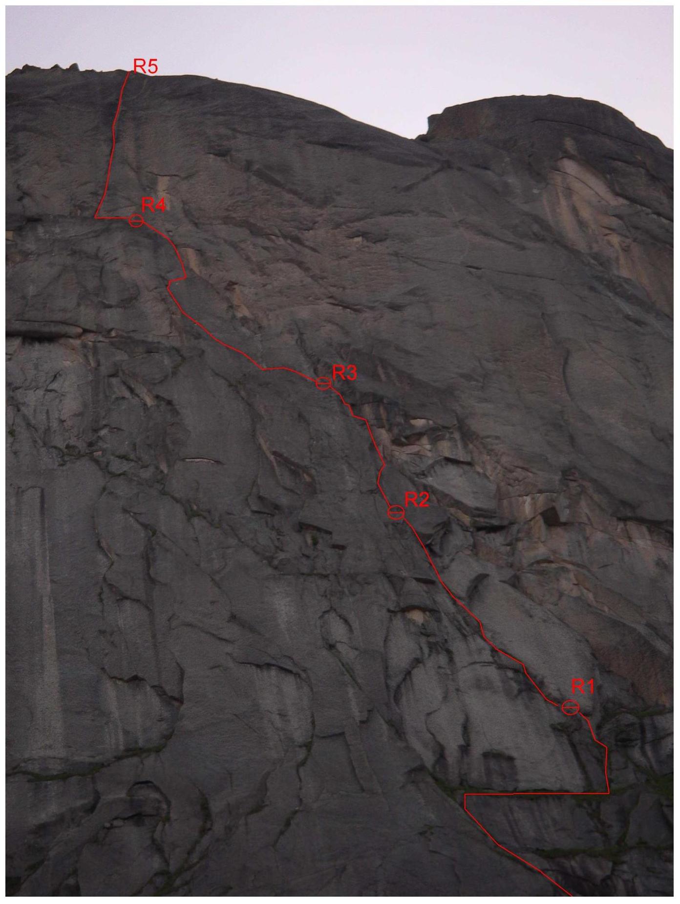
p. Zvezdniy. Right part of the South wall. "Thread" of the wall part of the route. Technical photograph.
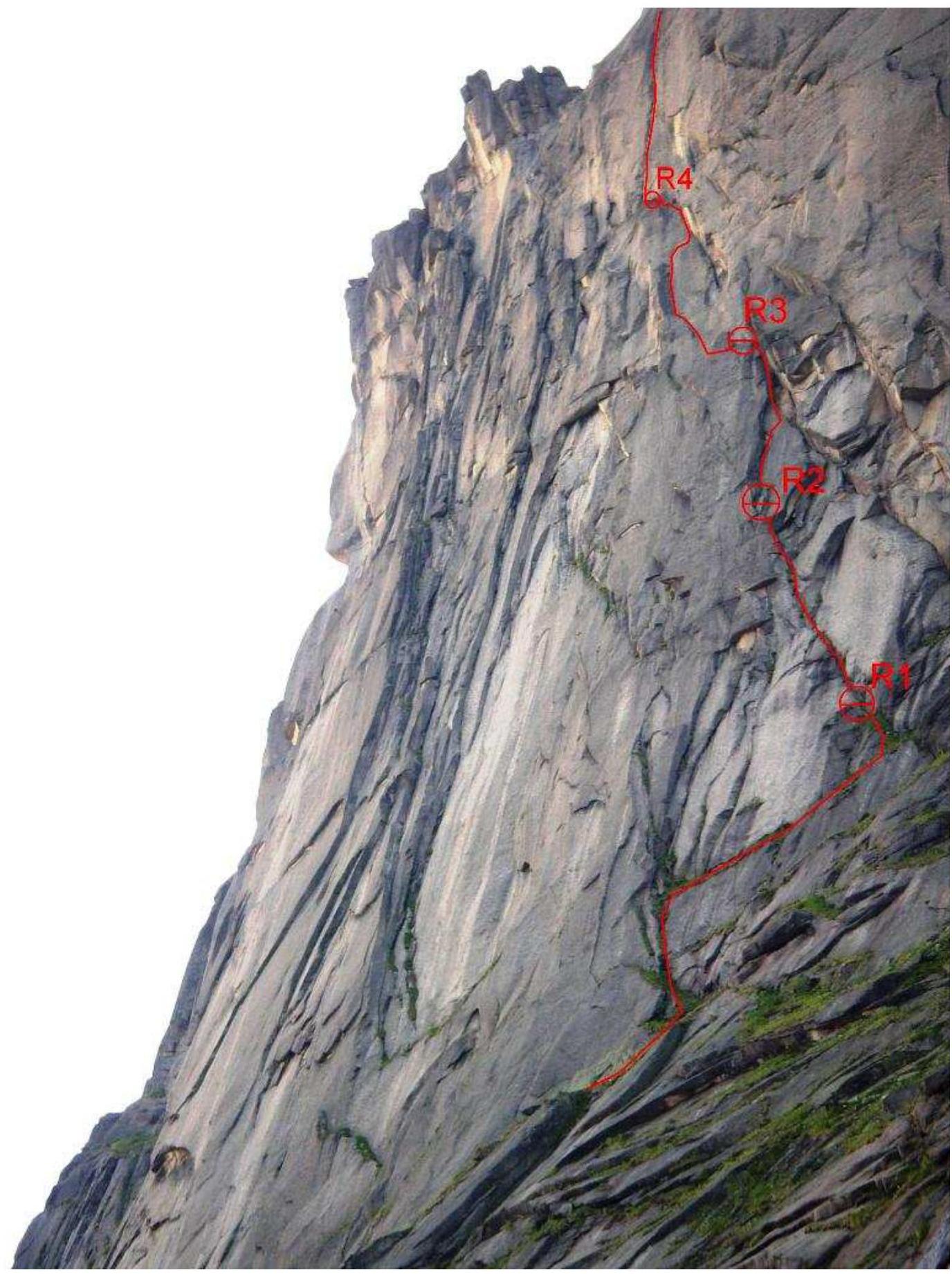
p. Zvezdniy. Right part of the South wall. "Thread" of the wall part of the route. Technical photograph. View from the right.