Irkutsk Regional Alpine Federation

Description
Ascent to v. "Flibustier" via the 3rd ridge (Tunkin Goltsy) Eastern Sayan. 2860 m. Irkutsk, 1971.
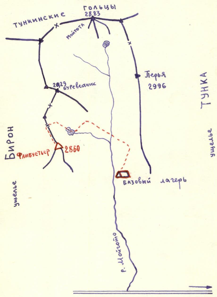
Geographical Information, Sports Characteristics, and History of the Exploration of the Moygato Valley
The Moygato valley is located in the middle part of the Tunkin Goltsy ridge in the Eastern Sayan.
Tunkin Goltsy is the highest ridge in the Eastern Sayan. The highest point is 3266 m in the upper reaches of the Ganga-Kharym valley. The ridge has alpine forms of relief. There are many peaks of interest to climbers.
The valleys are deep, covered with impenetrable taiga. The forest boundary lies at an altitude of 1700 m. The snow cover almost completely disappears by the end of summer. There is no glaciation.
The peak "Flibustier" is located in a lateral spur. The height of the peak is 2860 m.
The nearest settlement is the Arshan resort, located 30 km away, and 250 km from Irkutsk. From the valley to the base camp is an 8 km ascent through a very inaccessible valley (the use of pack transport is excluded) - 5-6 hours.
There are 7 peaks in the upper reaches of the valley, 5 of which have been conquered by Irkutsk climbers. They have laid out 8 routes of I-III category of difficulty. There are opportunities for passing several new routes.
Route Description
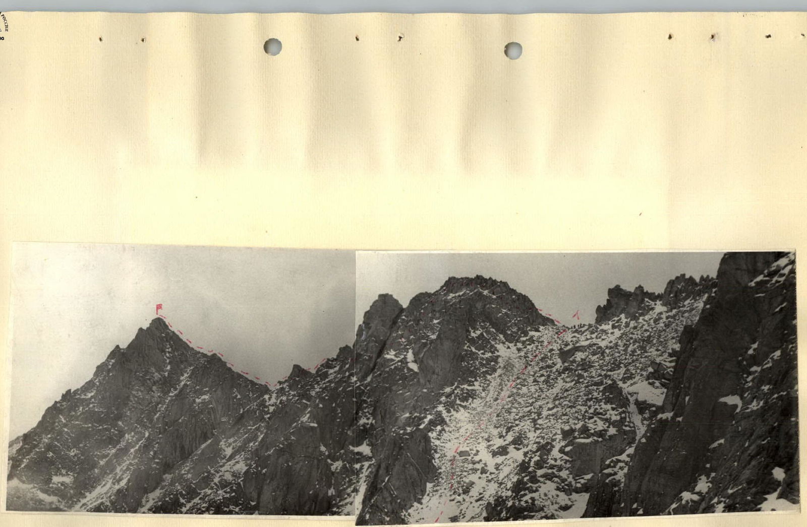
From the base camp, having overcome the moraine rampart, we move up the valley for several hundred meters. Then, having overcome a steep ascent (300 m elevation gain) consisting of large and medium-sized boulders, we enter a hanging cirque, from where the steep rocky walls of the peaks Flibustier and Burevestnik open up (photo). On the ascent, extreme caution is required due to many unstable stones. In the upper part, where the steepness reaches 50°, smoothed outcrops of rock appear, necessitating alternating belay, and in places, fixed ropes. We move deeper into the cirque. The path follows the accumulation of large boulders, associated with great difficulties. It is necessary to pass with caution. After the lake, we overcome the ascent, the nature of the relief is the same, chaotic accumulations. Having reached the upper reaches of the cirque, we turn left and begin the ascent to the ridge (photo).
Ascent along a snow-covered medium scree. Steepness 30-35° (photos 3, 4). On the saddle, there is a control cairn.
Section R0-R1
Section R1-R2
Further, the path follows the ridge. The ridge is horizontal, with small ascents and descents. All towering rocks are bypassed on the right. Movement is mostly simultaneous (photos 6, 7, 8, 9). The first rocky massif is passed with alternating belay, one rope with fixed ropes (photo 5). The rock, resembling a toad, is bypassed on the right (photos 10, 11). The detour is along monolithic boulders, with alternating belay (photos 12, 13, 14, 15).
Section R2-R3
Further, ascent along a steep slope consisting of accumulations of large boulders (photos 12, 1, 10), exit to the pre-summit ridge (photo 13). Movement is below the ridge, bypassing all gendarmes on the right (photos 14, 15). Descent from the summit is via the ascent route.
The entire route takes 9 hours. The route corresponds to 1B category of difficulty.
Table of Main Characteristics
Peak "Flibustier" 1B category of difficulty.


| Date | Section | Slope, ° | Length, m | Relief Characteristics | Category of Difficulty | Method of Passage and Belay | Weather Conditions | Time Taken | Number of Pitons |
|---|---|---|---|---|---|---|---|---|---|
| September 28, 1971 | R0-R1 | 35° | 800 | Snow-covered large and medium scree | 1B | Simultaneous | Overcast, calm | 1 | – |
| R1-R2 | 15° | 1200 | Ridge, rocks, accumulations of large boulders. | 1B | Alternating, fixed ropes, belay via ledges. | Overcast, wind | 1 h 45 min | ||
| R2-R3 | 40° | 450 | Ridge, rocks, large boulders | 1B | Alternating, belay via ledges. | Wind, fog | 45 min |
Total: 2450 m, 3 h 30 min.
Length: 30 km.