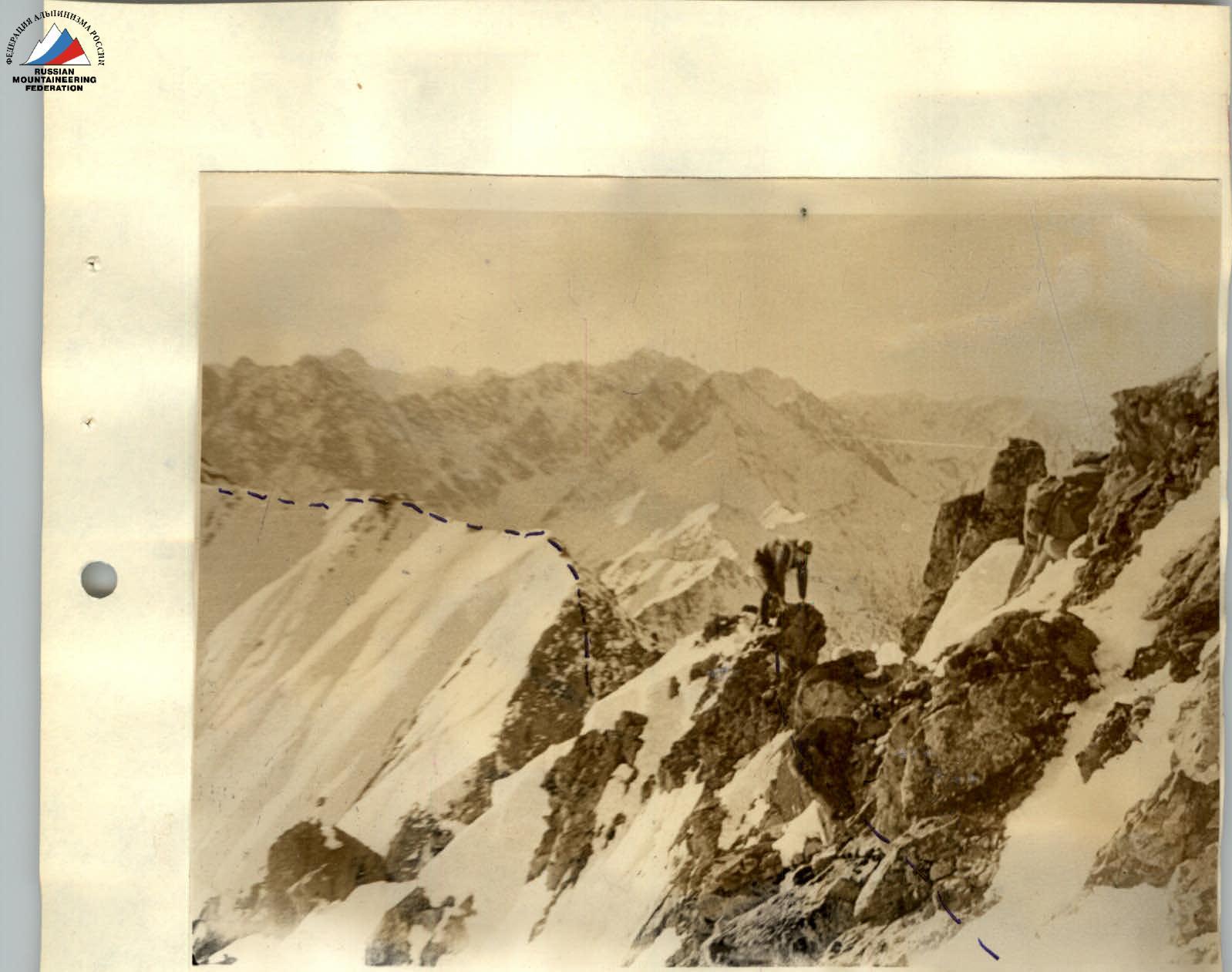
Map of the area. After 1.5 hours, we approach the gap. In this location, the ridge drops sharply to the north; to the right, there is a steep, deep snowy slope, making a detour impossible (photo 7A). From the ridge, the height of the rocks before the gap is 4 m (photos 4, 5), and the depth of the gap is up to 60 m.
The descent into the gap begins with a rope descent, sports style, from the upper part of the 8 m gendarme (organization of the descent in photo 6).
Traverse along a snowy ledge under overhanging rocks for 5 m. Then, another 7-meter sports descent follows down a sheer wall with a negative two-meter section onto an inclined snowy platform (photo 6). Insurance is combined through ledges and one rock hook. The last participant descends both times on a double rope. The top is secured to available convenient and reliable ledges.
Next is simultaneous movement across chaotically piled large boulders, and after 10 m, another sports descent follows down destroyed rocks with a steepness of 45°. Insurance is alternating, through ledges. Caution, loose rocks!
The gap is the lowest section of the ridge – 2060 m. From the summit Обзорная to the gap, it takes 2.5 hours.
From the gap, a steep, sharp ridge continues with cliffs on both sides (photo 7A). The rocks are of medium difficulty, местами разрушены. Insurance along the 200 m section of the ridge is alternating, 60 m of rope protection, one rock hook.
The overall steepness of the 200-meter ridge section is up to 50°. Further, the ridge becomes gentler (photo 7A). A rocky ascent before the last ridge depression (photo 8) is bypassed on the right, below the ridge along snowy wide inclined ledges and destroyed easy rocks. Movement is simultaneous.
Descent under the pre-summit ascent is along destroyed rocks at 35°, up to 80 m long; be cautious of loose rocks!
Monolithic rocks of the pre-summit ridge are bypassed along a snowy slope with a steepness of up to 40° in the upper part along easy rocks; movement is simultaneous.
From the pre-summit shoulder, the final ascent is up to 300 m long, with a steepness of 30°, in the upper part up to 40° with rock outcrops, leading to the summit. From gap П to the summit, it takes 2.5 hours.
Descent from the summit is 100 m along the ascent path, then a turn into the first couloir of the southern slope and further into the cirque of Левая Кынгарга. From the summit to the winter hut, it takes 3 hours and 55 minutes, and the total route time is 12–13 hours.
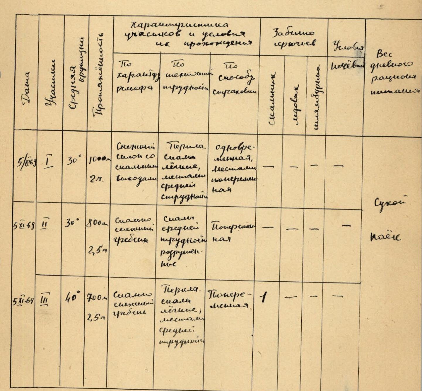
Table of main route characteristics.
-
R1 (August 5, 1969): Average steepness 30°, length 1000 m, 2 hours.
- Character: Alternating symbiosis with a rock ascent of medium difficulty.
- Difficulty scale: Rope protection. Rocks are easy, местами средней трудности.
- Insurance method: Simultaneous, местами попеременная.
- Hooks driven: Rock: 1. Ice: –. Bolts: –.
- Overnight stay conditions: Dry rations.
- Daily ration weight: –.
-
R2 (August 5, 1969): Average steepness 30°, length 800 m, 2.5 hours.
- Character: Rocky alternating ridge of medium difficulty, destroyed.
- Difficulty scale: Rope protection. Rocks are easy, местами средней трудности.
- Insurance method: Alternating.
- Hooks driven: Rock: 1. Ice: –. Bolts: –.
- Overnight stay conditions: –.
- Daily ration weight: –.
-
R3 (November 5, 1969): Average steepness 40°, length 700 m, 2.5 hours.
- Character: Rocky snowy ridge.
- Difficulty scale: Rope protection. Easy, местами средней трудности.
- Insurance method: Alternating.
- Hooks driven: Rock: 1. Ice: –. Bolts: –.
- Overnight stay conditions: –.
- Daily ration weight: –.
The summits Обзорная and Пирамида are located in the main watershed ridge of the Tunkinskie Goltsy ridge, Eastern Sayan, in the upper reaches of the Левая Кынгарга river valley.
The height of summit Обзорная is 2340 m, and Пирамида is 2400 m. Up to an altitude of 1800 m, the slopes are covered with forest.
From the winter hut at the confluence of Левая and Правая Кынгарга (according to benchmark 1202 m), the path lies upstream along the trail following the Левая Кынгарга river to the first right (orographic) tributary. Turning into the gorge of this tributary, we continue moving forward and reach the fork of the gorge in 20 minutes. One should turn into the right gorge, which begins with a canyon having steep slopes. Move on the left side along the way, using grassy ledges and "ram's foreheads."
Having passed the canyon (length about 200 m), one should gradually gain altitude. Reaching the upper forest boundary, move straight up towards the ridge.
The slope is steep with outcrops of slab-like rocks. Here is the start of the route, altitude 1908 m. The approach takes 1.5–2 hours.
The ridge is gentle, with fine gravel. After 300 m of movement along it, we reach a group of rocks, which are bypassed on the left along a steep snowy slope with small rock outcrops; movement is simultaneous.
Having bypassed the rocks, we come out onto a snowy ridge and descend along it to a saddle.
A group of rocks behind the saddle is bypassed on the left; the rocks are easy, and movement is simultaneous. A short snowy isthmus leads to a wide rock barrier 30–35 m high, which is overcome directly. The rocks are easy, the section is 7–8 m, with an average steepness of 40 to 60. Alternating insurance is provided through ledges. The section is of medium difficulty with rope protection; the ascent is sports style.
The further path to summit Обзорная goes along a not steep, wide ridge with rock outcrops, which are passed easily; movement is simultaneous. From the point of reaching the ridge to the summit (section R1) takes about 2 hours.
From summit Обзорная to summit Пирамида, there is a one-and-a-half-kilometer ridge (photos 1, 2). From the summit, a steep descent along a large snowy scree and a steep snowy slope (photo 3) leads to the ridge, with numerous rock outcrops. It is overcome in places with alternating insurance. The rocks are destroyed. Be cautious of snowy drifts!
Photo 2 — Descent from summit Обзорная.
Photo 3 — General view of the descent from the gendarme into the gap.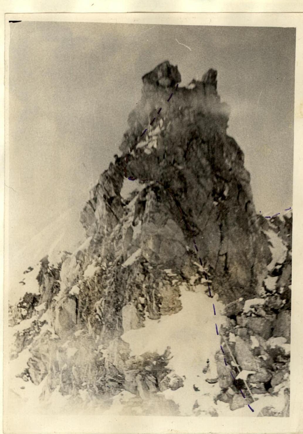
Photo 4 — R3 section. Character of the ridge.
Photo 5.