4344
IRKUTSK REGIONAL FEDERATION OF ALPINISM
Description
Ascent to peak "Perya" via the N ridge (Tunkinskie Goltsy) Eastern Sayan Mountains 2996 m. Irkutsk, 1971.
Geographical information, sports characteristics, and history of exploration of the "Moygoto" valley
The Moygoto valley is located in the central part of the Tunkinskie Goltsy mountain range, Eastern Sayan Mountains. Tunkinskie Goltsy is the highest mountain range in the Eastern Sayan Mountains, with the highest point at 3266 m, located in the upper reaches of the Gang-Khairym valley. The range has alpine relief forms and many peaks of interest to mountaineers.
The valleys are deep and covered with dense taiga. The tree line lies at an altitude of 1700 m. The snow cover largely disappears by the end of summer. There is no glaciation.
The peak "Perya" is situated in a lateral spur, separated from the main ridge by a deep saddle. The peak's height is 2996 m. The nearest settlement is the Arshan resort, located 30 km away; Irkutsk is 250 km away. From the valley to the base camp, it is an 8 km ascent through a very difficult-to-access valley (the use of pack transport is not feasible), taking 5-6 hours.
In the upper reaches of the valley, there are 7 peaks, 5 of which have been conquered by Irkutsk mountaineers. Eight routes of 1st to 3rd difficulty categories have been laid on these peaks, and there are opportunities for new routes.
Route description
From the base camp to the start of the ascent to the saddle is 2.5 hours up the valley.
Section R0–R1 (photos 2, 3, 4)
Ascent via large and then medium-sized snow-covered scree. The slope is 25-40°. There is a control cairn on the saddle.
Section R1–R2 (photos 5, 6, 7, 8, 9, 10)
Ascent to the foot of the "first feather" wall and then bypassing it on the left; movement with occasional belays through outcrops, 3 ropes of fixed protection. The final section of the bypass goes along a narrow inclined ledge above a deep precipice, and the rocks are fragile. It is recommended to abandon this route and ascend via a vertical chimney to the ridge and descend to the saddle. This section is technically more difficult but safer. The narrow, heavily fragmented crest behind the "feather" should be traversed with great caution. After the first "feather," there is an ascent via a snowy rise and then a straightforward bypass of the second "feather" along a wide ledge on the left.
Section R2–R3 (photo 11)
The most straightforward section. A fragile ascent is carefully bypassed on the right. Along the foot of the third "feather," we move through blocky terrain towards the fourth "feather," bypassing it on the right.
Section R3–R4
After bypassing the fourth "feather," we move along the fragmented ridge towards the sub-summit, from which the summit massif is visible (photo 12). It is recommended not to reach the sub-summit but to traverse it on the right with a descent. Descent for 70-80 m via fragmented large-block rocks; in places, there are challenging walls with fixed protection. Upon reaching a wide snowy couloir, we ascend to a rocky corridor.
Section R4–R5 (photos 13, 14, 15, 16, 17, 18)
Initially, along a snowy slope of 30-40°, then via snow-covered rocks, which are smooth. Belays are alternating, with fixed protection. Ascent via the right part of the corridor to a "niche," then a traverse left and upwards, a challenging section with fixed protection. Another rope and exit to a platform. One rope to the right and upwards along the foot of sheer smooth rocks and up a steep chimney, exiting to the ridge. In the chimney, there is fixed protection.
To the summit, the path goes via steep monolithic large-block rocks, with walls featuring very complex climbing and no bypasses. Everywhere, there is fixed protection. The exit to the summit is via a sheer smooth boulder with a lift-over. Descent from it is via down-climbing. Descent to the entrance of the corridor involves repeated down-climbing. From the platform to the niche, there is fixed protection. Further descent involves two ropes down-climbing (photos 19, 20, 21).
The further descent follows the ascent route.
Total time: on the route - 8 hours with approach and return to camp - 12 hours
The group assessed the route as Category 2B difficulty.
Group members:
- Shishkin V.I. - leader, 1st sports category.
- Bryansky V.P. - 1st sports category.
- Tokarev S. - 2nd sports category.
- Stanevich V. - 3rd sports category.
- Simatova L. - 3rd sports category.
-
- 3rd sports category.
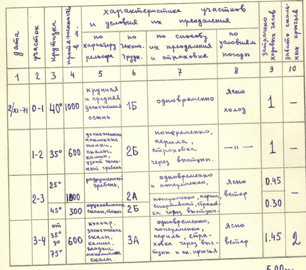
Table of key characteristics
peak "Perya" Category 2B
| Date | Section | Slope, ° | Length, m | Terrain characteristics | Technical difficulty category | Method of passage | Weather conditions | Time taken, hours | Number of pitons driven |
|---|---|---|---|---|---|---|---|---|---|
| 2/XI–71 | R0–R1 | 40 | 1000 | Large and medium snow-covered scree | 1 | Simultaneously | Clear, cold | 1 | – |
| R1–R2 | 35 | 600 | Snow-covered inclined ledges, rocks, chimney, narrow rocky ridge | 2 | Alternating, fixed protection, belays through outcrops | – | 1 | – | |
| R2–R3 | 25 | 1200 | Fragmented ridge | 2 | Simultaneously and alternating | Clear, windy | 0.75 | – | |
| 45 | 300 | Large-block rocks, walls | 2 | Alternating, fixed protection, down-climbing, belays through outcrops | – | 0.5 | – | ||
| R3–R4 | 35-75 | 600 | Couloir, snow-covered rocks, chimney, smooth monolithic rocks | 3 | Simultaneously, alternating, fixed protection, belays through outcrops and pitons | Clear, windy | 1.75 | 2 | |
| R4–R5 | |||||||||
| Total: 3500 m. |
ARSHAN 25 km
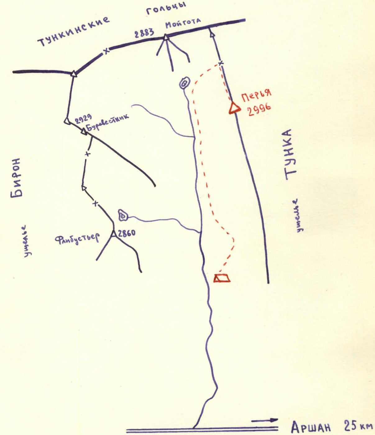
Photo 3
Photo 5
Photo 9
Photo 12
Photo 13
0
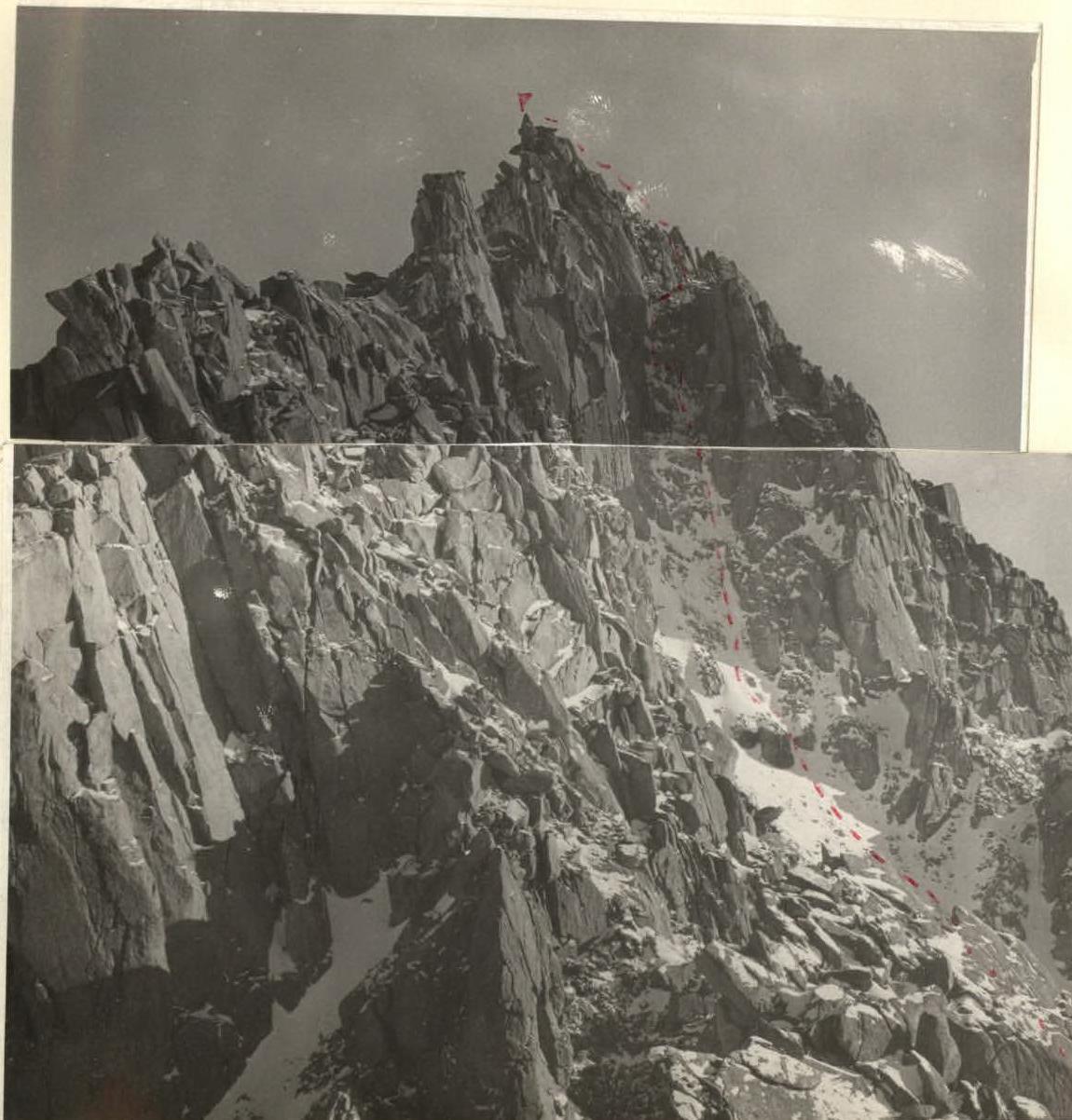
Photo 12
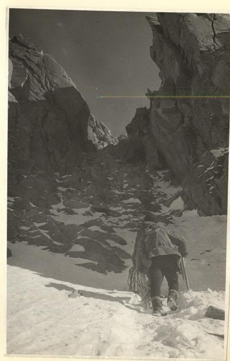
Photo 13