Geographical and Sporting Characteristics of the Area
The Barun-Khandagai valley is located in the Tunka Alps, 18 km from the Arshan settlement. Due to the lack of a trail in the valley, it is more convenient to access it through the Zun-Khandagai valley, which has an excellent trail, and then descend into Barun-Khandagai via a pass near the Dinosaur peak.
Approach times:
- To the first overnight stay (from the beginning of the valley) — 8 hours
- Through the pass to the assault camp — 6 hours
(see the map)
The Zun-Khandagai valley has classified routes:
- on the Soan peak 20 and 46
- on the Dinosaur peak 4A (unclassified)
- traverse of the Eagle Khandagai 4B.
Currently, descriptions are being compiled for a number of routes. There are more than 3 km to the forest boundary in the Barun-Khandagai valley. Several technically complex ridge routes of the 4th and 3rd categories can be laid out on the peaks surrounding the valley.
The ascent to the Neftekhimikov peak is the first attempt at classification in this interesting and significantly elevated area. It should be noted that the ascent via the northern buttress to the Neftekhimikov peak took place in low-snow conditions, which is very rare.
However, due to the northern exposure, there is almost no sunlight on the route, which creates known inconveniences during the ascent.
The variety of technical techniques requires the mandatory presence in the climbers' arsenal of:
- ladders,
- wooden wedges,
- duraluminum wedges.
The name of the peak has been submitted to the relevant organizations for approval.

Description of the Ascent via the Northern Buttress to the Neftekhimikov Peak
May 2. After exhausting 2-day approaches, the group rested and set out on a reconnaissance of the route in the second half of the day. (photo I) The reconnaissance results showed that the route is very interesting. To reach the edge of the buttress, it is necessary to overcome an 80-meter snowy wall. In addition, the buttress itself is a narrow edge bounded:
- on the left — by a couloir,
- on the right — by a vertical destroyed wall.
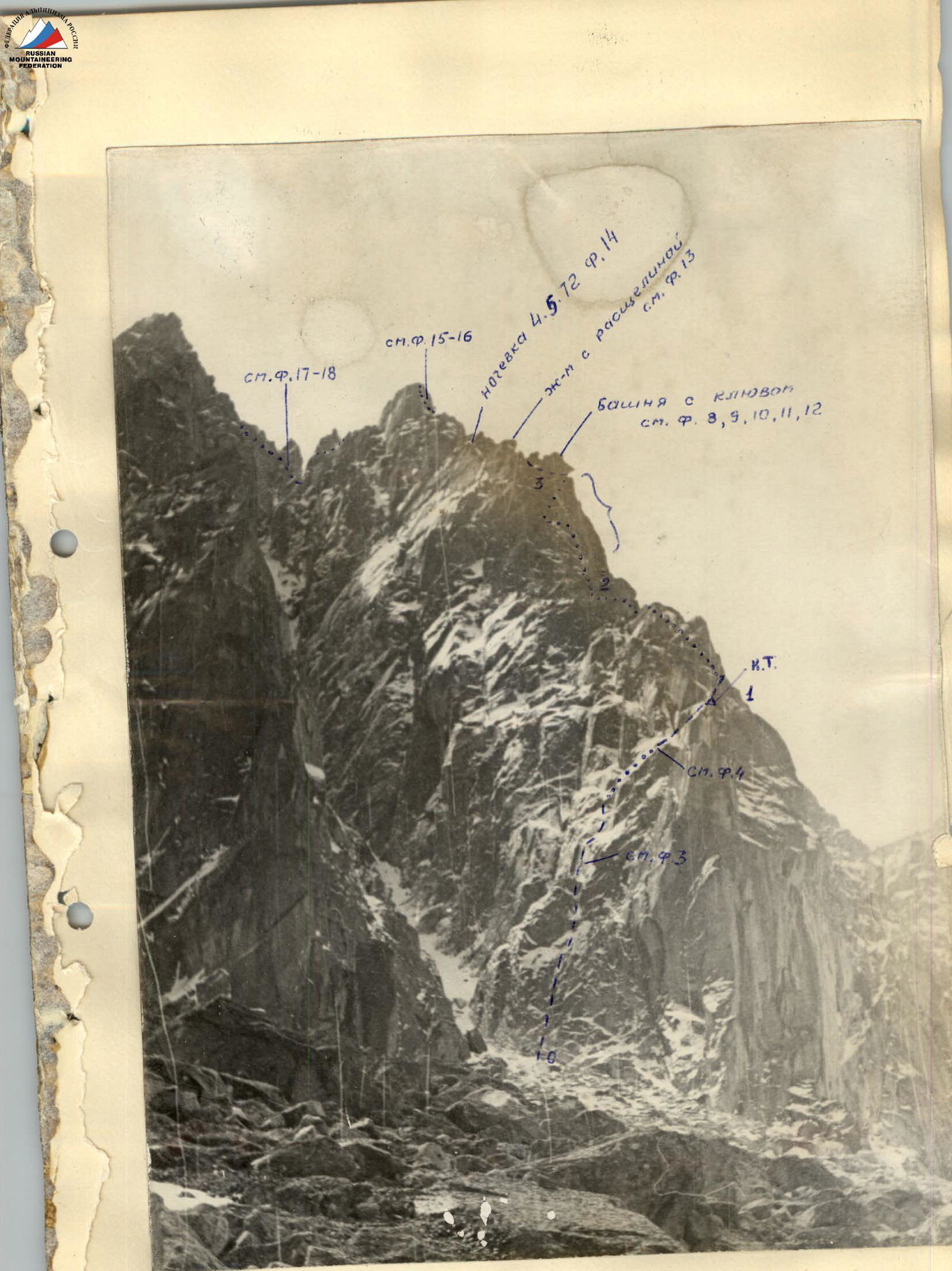
Section R0–R1 (Photo 2)
May 3. Considering the instability of the Sayans weather in May, we decide to pre-process the lower wall section of the route. The Nikonov — Cheremnykh team set out for processing at 9:00.
Having passed the first 40 m along the vertical wall, we reached a ledge. From it, 10 m up the smooth wall, where we had to drive in a single bolt (photo 3). Then, to the left, into a vertical angle, there is an exit to smooth slabs (photo 4) and an approach under the wall of the edge. A wall with a crack 6 m leads to a good site. We build a control cairn.
Section R1–R2
From the site, to the right, along the slabs with cracks along the edge. Free climbing. Further on, we encounter an inclined chimney with a plug at the top. The next wall is again a good site. From it, to the left, along a groove filled with snow (photo 5). Complex climbing under an overhanging chimney (photo 6). Having finished processing, we descended to the camp. We spent 6 hours, hanging 120 m of rope.
May 4. A fog is approaching from the valley, but we decide to set out. We spent 2.5 hours on passing the processed section and pulling out the backpacks.
The overhanging chimney 7 m (photo 7) with an iced left wall was passed with difficult climbing. We pull out the backpacks. Further, 80 m of the snowy ridge is passed alternately under a tower with a "beak" (photo 8).
Section R2–R3
We bypass the tower to the left and, via a chimney with ladders, exit to a ledge (photo 9). From it, we traverse to the left along the wall and, with ladders under the cornice (photo 10), move left – up to a ledge in a vertical angle (photo 11). Due to the limited number of holds, we have to go up the overhanging angle with ladders. Having passed a smooth slab, to which the angle leads (photo 12), we approach the site.
From it, there is an easy simultaneous movement under a tower with a crack on the right. We bypass the tower on the right along a vertical angle with ladders. Due to the impossibility of following the path of the first team, we drop the rope, and the rest climb up to the left along a snowy smooth angle (photo 13).
Section R3–R4
The next wall, 8 m, along a snowy inner angle, is passed with wooden wedges and a ladder; the weather is deteriorating, and there is still no place for an overnight stay.
Further, the edge is heavily snowy and destroyed, requiring cautious climbing with piton protection. On the way, there is a vertical wall 10 m with cracks. Climbing is extremely difficult. The cracks are clogged with ice; the snowfall has intensified. Unexpectedly, after a rope length of steep rocks, we found a small ledge under an overhanging slab on the left. The tent is only half accommodated, but as it turned out later, this is the most convenient overnight stay, although in a semi-reclining position (photo 14). We spent 11 hours of climbing time.
Section R4–R5
8:00 May 5. A light fog does not delay us, and we begin moving along heavily snowy rocks. Climbing is complex, with many loose rocks.
We approach a tower. We bypass it on the right, along an inclined smooth slab (photo 15), and along an overhanging chimney (photo 16) with very complex climbing using ladders. We exit to a ledge. In this section, we had to drive in 18 pitons. Further, to the right, along a heavily destroyed section with complex climbing. Protection is through ledges and pitons.
Section R5–R6
We approach the pre-summit tower. The wall is very complex due to significant destruction (photo 17). We exit to a ledge and from it to an overhanging inner angle with loose blocks below (photo 18). Climbing is extremely difficult. This is the key point of the route. For the last time, we pull out the backpacks onto the saddle. We move alternately to the base of the couloir and, having crossed it to the right, climb up a destroyed wall to the right of the summit onto the ridge. From here to the summit is 40 m. Easy climbing. On the summit, not finding any signs of previous climbers, we build a control cairn. We spent 10 hours of climbing time.
Section R6–R7
The descent from the summit along a simple destroyed ridge and a wide couloir to the camp took 2.5 hours.
Considering many years of experience in climbing in the Sayans, the group believes that the route in winter conditions corresponds to category 5B.
Group Composition
- Nikonov V.P. — leader, 4A+4A+4B+4B+5A.
- Nikolaeva I.M. — II category, 4A+4A+4A+4B+5A.
- Sazanov V.V. — II category, 4A+4A+4B+4B.
- Cheremnykh A.F. — III category.
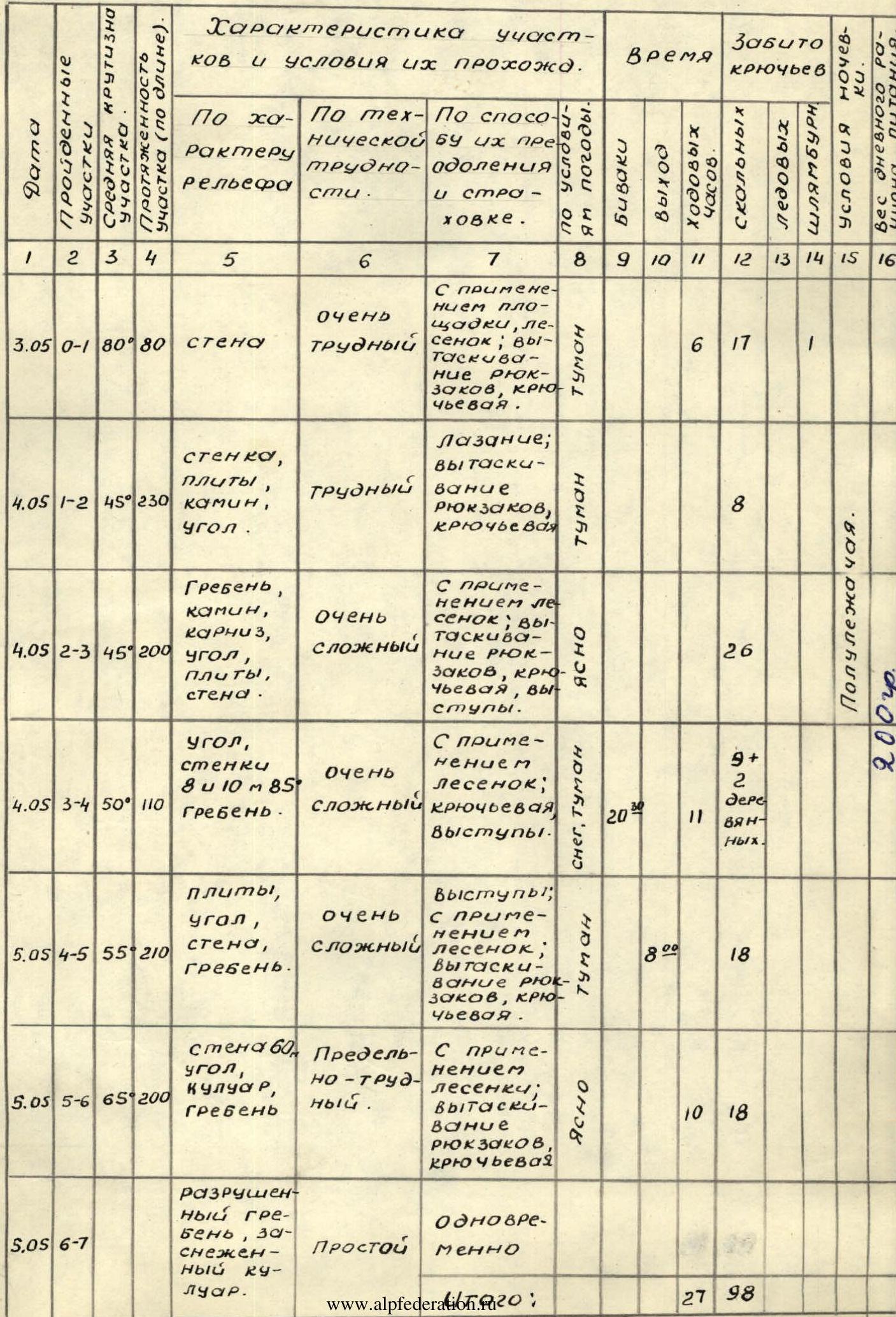
Table of the main technical sections of the Northern buttress of the Neftekhimikov peak at 2850 m. Route length — 1030 m. Average slope — 60°.
 Map of approaches to the Neftekhimikov peak.