Peak Monakh from the west, from the saddle between Peak Monakh and Charskie Zori Suvorkina L.D. East Sayan 6.1
Climbing Passport
-
Climbing category: technical
-
Region: East Sayan, Tunkin Goltsy, Barun-Khadagai valley
-
Summit: 2850 m. Peak Monakh from the west, from the saddle between Peak Monakh and Charskie Zori
-
Proposed: 2B category of difficulty
-
Route type: combined
-
Route characteristics:
Elevation gain: 840 m. Route length: 793 m. Route length of 4th category of difficulty: 40 m. Route length of 3rd category of difficulty: 18 m. Route length of 2nd category of difficulty: 265 m. Route length of 1st category of difficulty: 370 m. Steepness of the main part of the route: 45 °
-
Equipment used on the route:
Number of protection placements: 26
-
Total climbing hours: 10 hours
-
Team leader: Suvorkina Lyudmila Davydovna, Candidate Master of Sports
-
Team members: Govlyasek Olga Vladimirovna, badge holder Zakharov Alexander Viktorovich, badge holder Kuptsov Pavel Nikolaevich, badge holder Trzbyatovsky Nikolai Grigorievich, 1st sports category
-
Coach: Suvorkina Lyudmila Davydovna
-
Date of starting the route: October 26, 2008
Summit reached: October 26, 2008 Return: October 26, 2008
-
Organization: Krasnoyarsk City Alpinism Federation
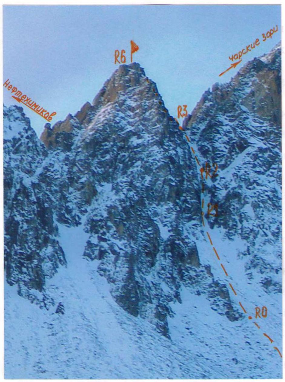
Photo 1 — Peak Monakh, 2850 m.
Route description
From the base camp on the forest edge, we follow the trail up the valley, bypassing Peak Neftehimikov to the right. We pass by a cabin, a lake, and ascend to a terrace closer to Peak Neftehimikov. The ascent from the trail is via scree and snow, 700 m., to the narrowing of the couloir between Peaks Monakh and Charskie Zori. We rope up.
R0–R1 — snowy couloir 300 m. 30–35 ° 1. Simultaneous movement. R1–R2 — rock wall, covered with ice 40 m. 80 ° 4. 8 protection placements. Rappel.
R2–R3 — snowy couloir 120 m. 35–40 ° 2, in the middle of the wall 10 m. 80 ° 3. Exit to the ridge. 6 protection placements. Rappel.
R3–R4 — movement along the ridge in belay 70 m. 35–40 ° 1 with sections of 2.
R4–R5 — wall 30 m. 45 °, traverse left along a ledge around a gendarme 12 m. 2, descent from the wall 3 m. 90 ° and ascent to the saddle 5 m. 70 ° 3. 8 protection placements. Rappel.
R5–R6 — descent from the saddle to the other side of the ridge 3 m., ascent left via a chimney 20 m., followed by small ledges, walls 40–50 ° 80 m. 2. 6 protection placements. Rappel.
Descent via the ascent route.
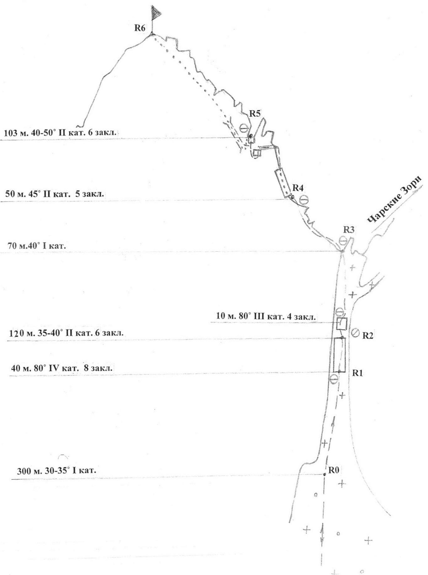
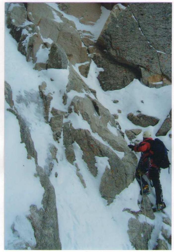
Photo 2 Section R1–R2
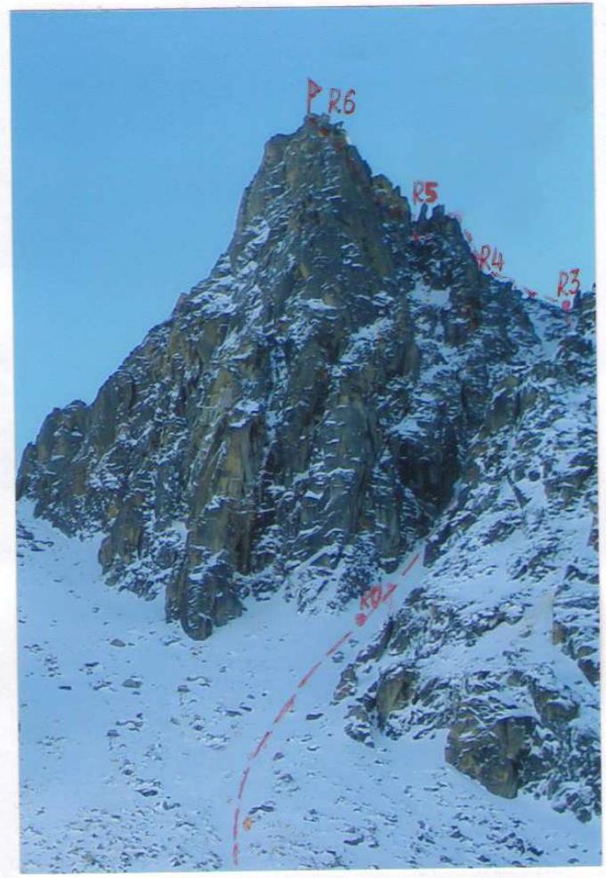
Photo 3 Route profile
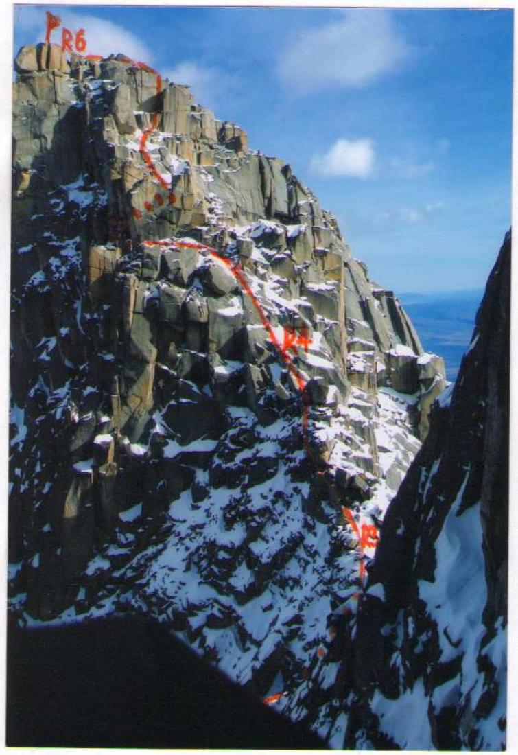
Photo 4 Section R3–R6. Photo from Peak Charskie Zori
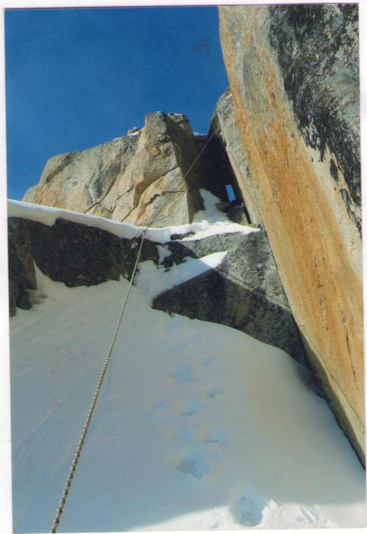
Photo 5 Section R5–R6

To the southwest of Lake Baikal, in the southeast of the vast East Sayan mountain system, lies the large Tunka Goltsy mountain range. To its south are the steppes of the Tunka valley, and to the north is the picturesque Kitoy river valley, beyond which stand the Kitoy Goltsy mountains. Further north lies the Central Sayan plateau, the Big Sayan mountain range, and northeastern Tuva.
Winters in Tunka are cold and windless, with many sunny days. Temperatures can drop to −38–40 °C at their lowest, with average temperatures ranging from −17 to −25 °C. Snowfall is generally scarce. Spring is unsettled, with frequent light snowfalls. Temperatures rise above zero in April. Avalanche danger arises in late March and persists until mid-May, though instances have been recorded in October and November. Summers are cool and rainy, especially in the latter half of July and August, with thunderstorms and heavy downpours. Autumns are clear and warm. The southern slope of the Tunka Goltsy hosts the Arshan resort.
In the early 1960s, climbers from Irkutsk, Bratsk, and Ulan-Ude began a mass assault on the peaks of Tunka. The most accessible valleys were explored:
- Kyngarga
- Moigoty
- Zuun-Khandagai
- Barun-Khandagai
The Barun-Khandagai valley is located between the Bilyuta and Zuun-Khandagai valleys, 12 km from the Arshan resort. To get there from Arshan, head west through the village of Tagarkhay (7 km) to the "Lesnichikha" clearing (5 km), then into the left valley. The trail initially follows the left bank of the river, then crosses via a log bridge to the right bank, continuing through dense forest, often far from the water.
The approach with a load takes 5–7 hours. The base camp is on the forest edge. Notable peaks in the area include:
- Barun 2874
- Neftehimikov 2850
- Kupol 2962
- Stol 2940.
Peak Barun has been climbed via routes of 1B and 2A category of difficulty, Peak Monakh via 2B, and Charskie Zori via 3A. These climbs have been repeated by local and Krasnoyarsk climbers, though they are not listed in the classifier.
- Krasnoyarsk, Karla Marksa ave., 49 Suvorkina Lyudmila Davydovna obednin@list.ru kmcp@inbox.ru