Brief Geographical Overview of the "Irkutsk" Peak Area
2742
The 2816 m "Irkutsk" peak is located in the eastern part of the Tunka Goltsy mountain range, Eastern Sayan. The range stretches from west to east for 150 km, approaches the southwestern tip of Lake Baikal, and serves as a watershed for the Irkut and Kitoi rivers, left tributaries of the Angara River. The vegetation is typically taiga, represented by:
- Cedar,
- Pine,
- Larch. The forest boundary is at an altitude of 1880–1900 m. The fauna is rich and diverse.
The Tunka valley is known for its many mineral springs. The most famous of these is the Arshan spring, on which a resort of all-Union significance has been established.
Administratively, the Tunka Goltsy range belongs to the Buryat ASSR.
The "Irkutsk" peak is located in the upper reaches of the Zun-Khandagai river gorge.
Climatological Information
The climate of the area is sharply continental. In the valley, the average temperature of the winter months is low (down to –40 °C), and the minimum temperature in the mountains is 5–10 degrees higher. In summer, cloudiness and precipitation increase in the mountains compared to the valley, and the air temperature decreases. Large diurnal temperature fluctuations are characteristic. In winter, weak southeast winds prevail. In summer, due to the passage of western cyclones, northwest winds dominate.
The amount of precipitation in the mountainous areas during the warm period reaches 500 mm, and in winter, 600 mm. The maximum snow cover height occurs in late February – early March. The snow line passes at an altitude.
The transition of the average daily temperature through 0°C in spring occurs after May 10, and in autumn, in early October. The winter period is from October 10 to May 15. From November to mid-May, the Sayan rivers are ice-bound, and deep, loose snow lies in the gorges. By May, some open snowfields become firn, but the snow generally retains its looseness until it melts. Ice fields and aufeis along the river gorges can persist until mid-July. Numerous high-altitude lakes are completely ice-free in July. There is no glaciation in the valley area.
Hazards
Hazardous phenomena in the mountains include: low temperatures, winds (sometimes with snow, even in July), snow avalanches (especially hazardous from February to May), rockfalls are rare, but heavily fragmented rocks can be hazardous with careless movement, especially in couloirs.
Travel to the Area and Approach to the Base Camp
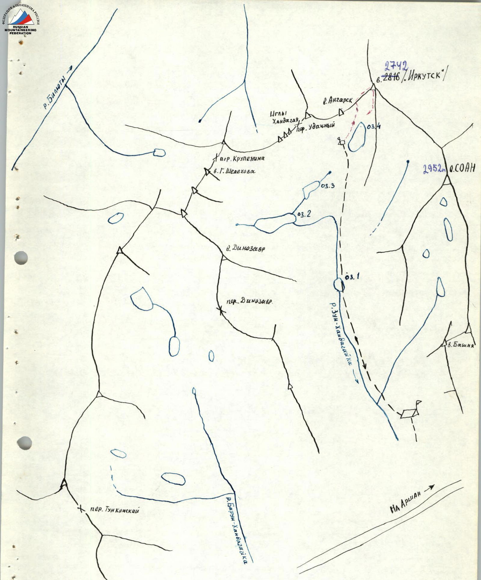
Travel from Irkutsk is by bus to the Arshan resort, and then by passing cars on a dirt road to the Tagarkhay village, and further to the dry bed of the Zun-Khandagai river.
If charter transport is available, it is not necessary to go through Arshan; the turnoff to Tagarkhay is 5 km before Arshan.
When traveling from Tagarkhay to the Zun-Khandagai riverbed, it is advisable to have a guide.
Further cargo delivery is possible:
- On foot with backpacks
- By helicopter It is possible to use pack transport, especially in summer, by agreement with the local population.
From the clearing, ascend the Zun-Khandagai river gorge, initially on a trail, which then disappears; proceed along the left orographic bank of the river. At the beginning, the riverbed is dry; water appears after 1.5 hours of walking. In the upper reaches, the river is hidden under ice and snow (late October – May).
The slopes are difficult to traverse, overgrown with trees and shrubs, and are partly rocky and talus-covered. Therefore, it is recommended to follow the river for most of the journey.
The path along the river is complicated by large boulders and, in places, involves climbing, made more difficult by backpacks.
The gorge is extensive and can be traversed in 1–2 days (depending on the group's composition and snow cover conditions).
The recommended location for the base camp is at the confluence of the Zun-Khandagai river into its left and right tributaries, near the forest boundary.
The indicated base camp location is convenient due to the availability of firewood and the possibility of accommodating a large team.
Map of the area
Route Description
To the 2816 m "Irkutsk" peak via the southwest rocky ridge. Ascent date: May 7, 1975. From the base camp (1800 m), located at the confluence of two streams that form the Zun-Khandagai river, the group needs to reach the "Irkutsk" peak (see diagram).
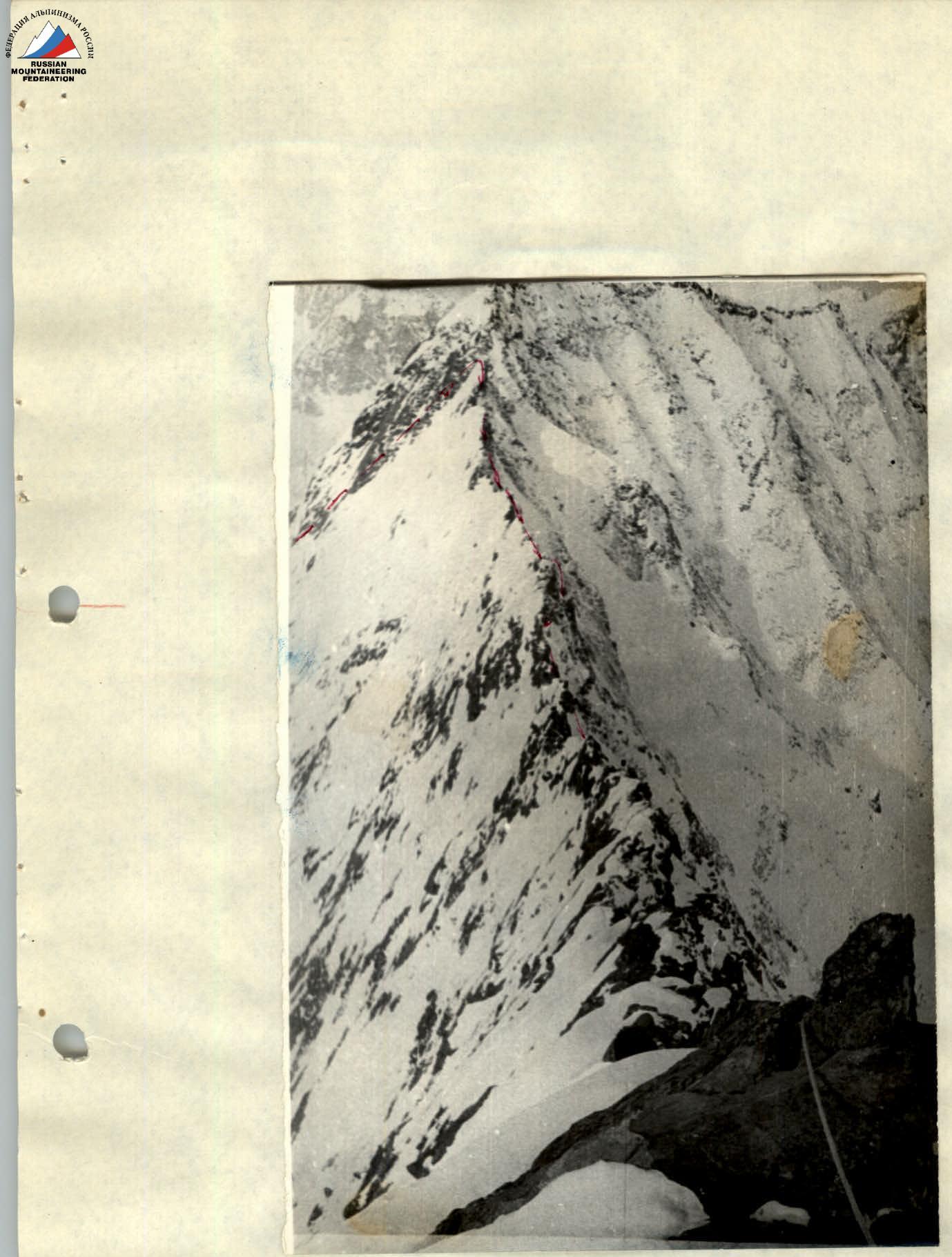
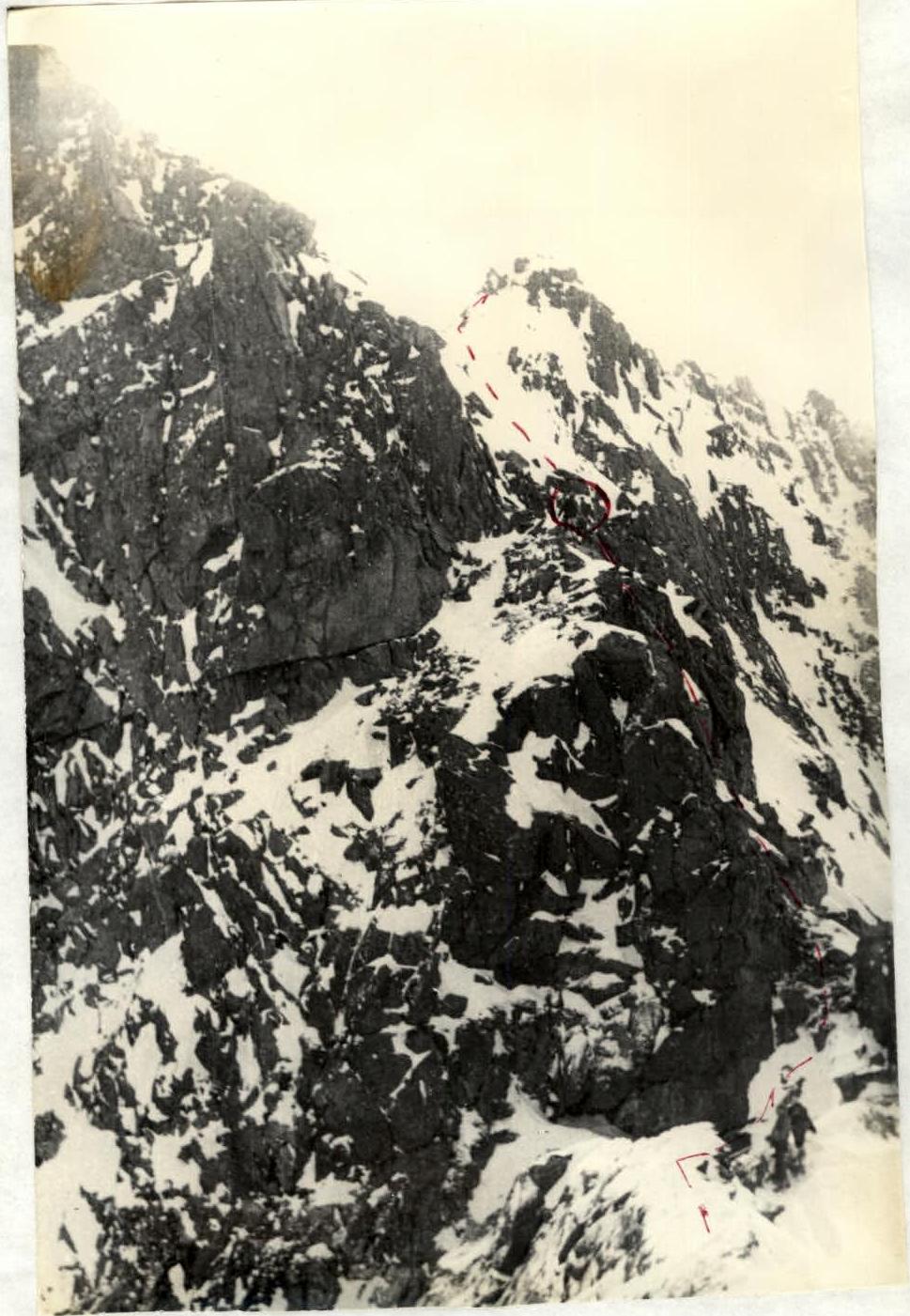
The path initially follows the stream flowing from the main cirque. Then, 500 m before the second lake in the main cirque, traverse the slope with a gain in altitude in a northeast direction, leaving the third lake on the left, and reach the fourth lake, from which a panorama of the "Irkutsk" peak opens up (photo 1).
The journey from the base camp to the start of the route takes 3 hours on good snow crust.
The weather is good, with a light breeze.
Section 0–1 From the lake, the route follows a snowy slope at the lowest part of the ridge. At the end of the section, movement is in three steps. Simultaneous insurance via ice axe (photo 2).
Section 1–2 Further along slopes of medium difficulty in the direction of a window in the ridge. 2 ropes. Piton insurance. Rocks are monolithic, snow-covered (photo 3).
Section 2–3 From the window, the route goes right along the ridge, simultaneously, with sections of alternating movement. Insurance via ledges. Short walls of medium difficulty up to 5 m are traversed by climbing. Insurance via ledges and pitons (photos 4, 5, 6, 7).
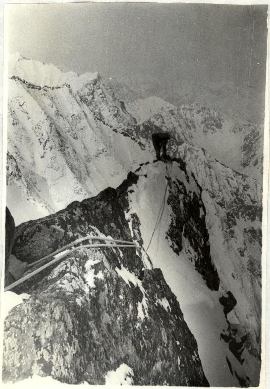
Section 3–4 A narrow, knife-edged ridge leads to the first wall, 15 m high. Rocks are of medium difficulty. Piton insurance (photo 8). Further, the narrow ridge approaches the second wall, 12 m high. Piton insurance (photos 9, 10).
Section 4–5
After the wall, there is a narrow, snow-covered ridge. Simultaneous, then alternating movement, insurance via ledges (photo 11). A 20 m ascent leads to a 40-meter narrow, knife-edged ridge (photo 12).
Section 5–6
Further, two ropes of easy rocks. The ascent at the end of the section is bypassed on the right. Alternating insurance via ledges (photo 13).
Section 6–7
Further along the ridge, with a slope angle of 15–20°, there are 5 gendarmes. The gendarmes are traversed "head-on". Climbing is easy, partly medium. Insurance via ledges and pitons (photos 14–15).
Section 7–8
Ascent to the summit. One rope. Rocks are of medium difficulty, insurance via ledges and pitons (photo 16).
Section 8–9
Descent from the summit is along the southern ridge, 150 m. A 2 × 40 m sport descent to a talus shoulder with a slope angle of 80°. Further, to the left in a couloir, descent by sport means — 2 × 40 m to a snow-covered slope with a slope angle of 50°.
1st descent option — via the ascent route. The entire route from the base camp to the base camp took 16 hours; 17 pitons were driven.
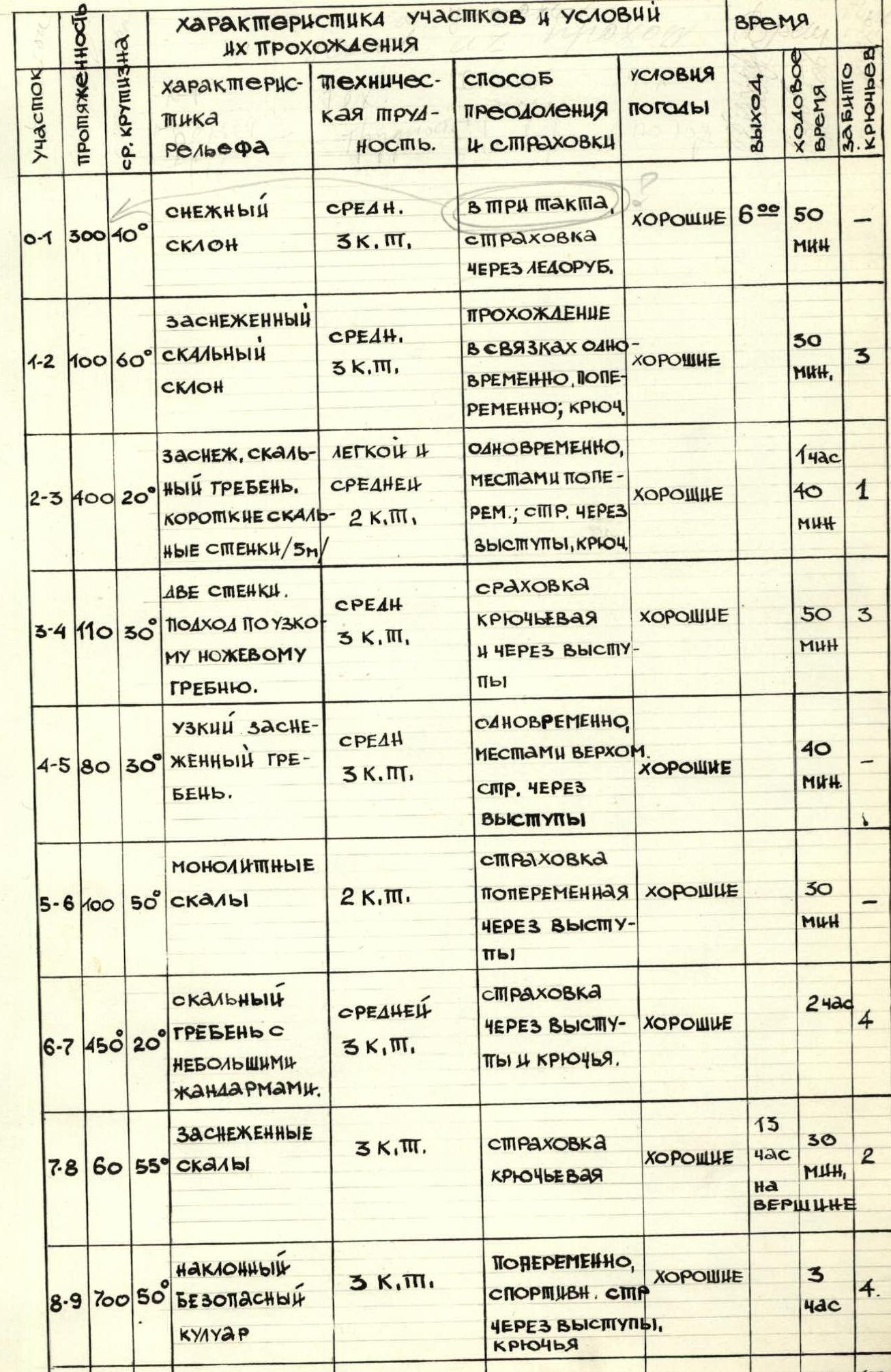
Table of Main Characteristics of the Route by Sections
| Section | Length | Average Slope Angle | Terrain Characteristics | Technical Difficulty | Method of Overcoming and Insurance | Weather Conditions | Time (walking) | Pitons Driven |
|---|---|---|---|---|---|---|---|---|
| 0–1 | 300 m | 40° | Snowy slope | 3 cat. diff. | In three steps, insurance via ice axe | Good | 60 min | 50 |
| 1–2 | 100 m | 60° | Snow-covered rocky slope | 3 cat. diff. | Simultaneous and alternating movement in rope teams; pitons | Good | 30 min | 3 |
| 2–3 | 400 m | 20° | Snow-covered rocky ridge. Short rocky walls /5 m/ | 2 cat. diff. | Simultaneous, partly alternating; insurance via ledges, pitons | Good | 1 h 40 min | 1 |
| 3–4 | 110 m | 30° | Two walls. Approach via a narrow knife-edged ridge. | 3 cat. diff. | Piton insurance and via ledges | Good | 50 min | 3 |
| 4–5 | 80 m | 30° | Narrow snow-covered ridge. | 3 cat. diff. | Simultaneous, partly belaying. Insurance via ledges | Good | 40 min | - |
| 5–6 | 100 m | 50° | Monolithic rocks | 2 cat. diff. | Alternating insurance via ledges | Good | 30 min | - |
| 6–7 | 450 m | 20° | Rocky ridge with small gendarmes. | 3 cat. diff. | Insurance via ledges and pitons. | Good | 2 h | 4 |
| 7–8 | 60 m | 55° | Snow-covered rocks | 3 cat. diff. | Piton insurance | Good | 13 h 30 min, at the summit | 2 |
| 8–9 | 700 m | 50° | Inclined safe couloir | 3 cat. diff. | Alternating, sport insurance via ledges, pitons | Good | 3 h | 4 |
| Total | 2300 m | 10 h 17 min |
Section R2–R3. Photo 3.
Section R4–R5. Photo 4.
Section R5–R6. Photo 5.