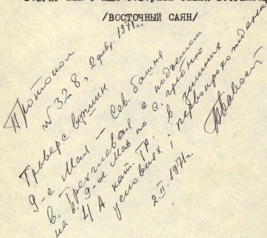
TRAVERSE DESCRIPTION:
v. BRIG – peak 9 May – North Tower v. TREHGLAVAYA.
/EASTERN SAYAN/
- ANGARSK, 1970 – The peaks of the specified traverse are located in the Tunka Goltsy ridge in the Eastern Sayan, in a long lateral spur, which serves as a watershed of the BUGOTOY and KYNGARGA rivers.
- Tunka Goltsy is the highest ridge in the Eastern Sayan, stretching in a latitudinal direction.
- The highest point is 3266 m above sea level in the upper reaches of the GANGA-KHAIRY river.
- In general, the ridge has sharp alpine forms. For 100 km – from the Arshan resort in the east to the Shumak pass in the west – it has many peaks of great interest to mountaineers.
The gorges are deep, covered with impassable taiga. The forest boundary on the southern slopes is 1880 m, on the northern ones – 1600–1700 m. The snow cover almost completely disappears by the end of summer. There is no glaciation. The peaks of the traverse BRIG – peak 9 May – TREHGLAVAYA are located on a horseshoe-shaped ridge.
The nearest settlement is the Arshan resort, 225 km from Irkutsk.
From the resort to the base camp at the confluence of the right and left Kyngarka rivers:
- 4 hours walking – ascent along the gorge.
From the base camp to the assault camp in the North circus:
- 3 hours walking.
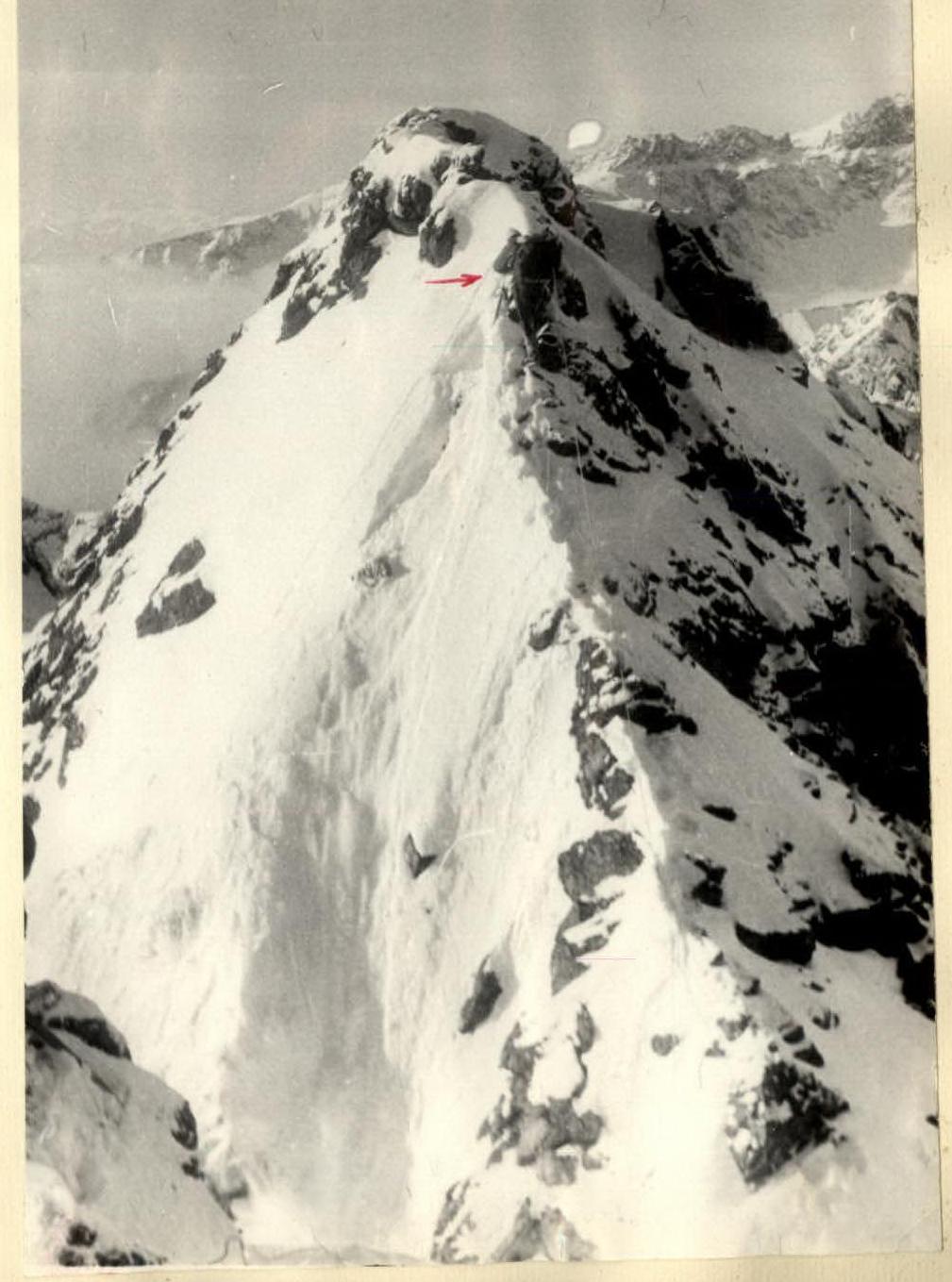
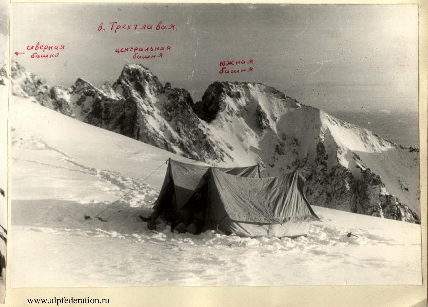
Trehglavaya peak:
- BRIG-peak
- 9 May
- North Tower
- v. TREHGLAVAYA.
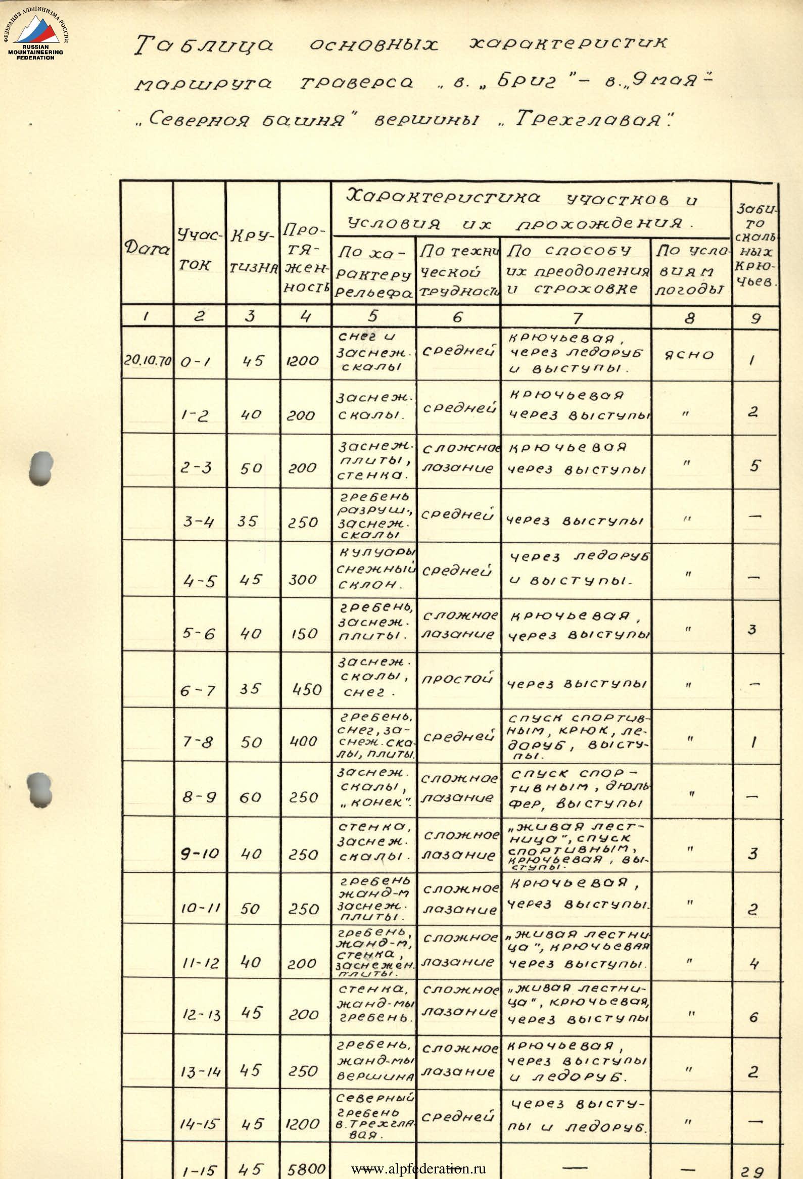
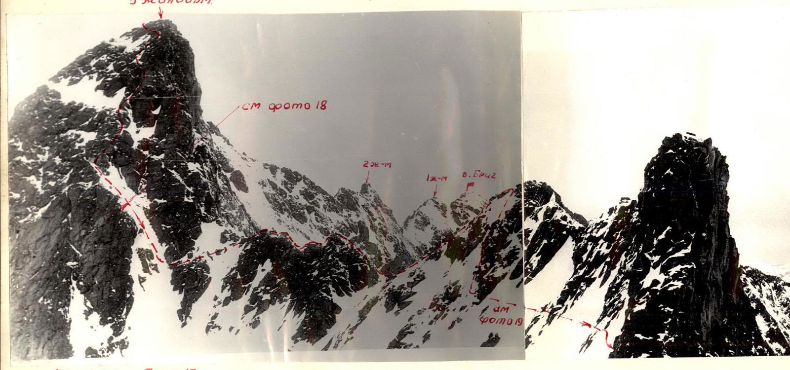
Section 0–1
We set out on the route at 7:00 from the North circus (see map). Ascent along a snowy slope (45°) (photo 1,2) to the exit of a narrow couloir 200 m, simultaneous movement. Then along the couloir (35°) simultaneously 200 m to the rocks on the right. Along the destroyed rocks (photo 3) we rise to the right side of the couloir 15 m and up to the fork of two couloirs, simultaneous movement. Here we tie in and continue moving, sticking to the ridge of the southern counterfort of the peak. Along simple snow-covered rocks, we approach the saddle between the couloirs (photo 4). Then along the snow-covered rocks (35°) 1 rope of handrails, then 1 rope alternately, insurance through ledges. We rise to a snowy ascent and along it we approach the pre-summit rocks. Along a wide snow-covered corner (40°) 1 handrail, 1 piton, then along a snowy slope (45°) and a rocky ledge we ascend to the BRIG peak. Time to reach the peak is 4 hours.
Section 1–2
Descent from the peak (photo 4a) along a destroyed rocky ridge (40°) 25 m to the saddle, alternate movement, insurance through ledges. The 1st gendarme is taken head-on (photo 5) along snow-covered slabs (45°), 30 m, handrails, 2 pitons. From the gendarme, descent on 1 rope to the saddle, simultaneous movement, and from it to the right along the descent of the rocky ridge, 2 ropes, alternate movement, to the saddle. Then along the talus and snow-covered simple rocks under the 1st tooth.
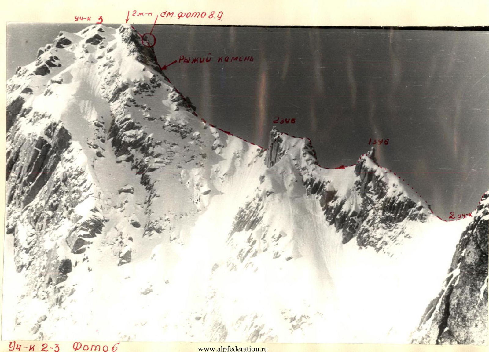
Section 2–3 (photo 6)
The 1st tooth is passed head-on (photo 7) along snow-covered slabs (50°), handrails, 3 pitons, difficult climbing.
The 2nd tooth (photo 6) is taken head-on along snow-covered slabs (50°) 15 m, insurance through ledges, handrails.
Then along the ridge to a large red stone (photo 6), alternate movement, along destroyed rocks.
From the stone head-on along the slabs (60°) to the negative corner (photo 9), 20 m.
The negative corner 1.5 m is passed by very difficult climbing with pulling out the backpack.
Then along the destroyed slabs 10 m (photo 8) (Loose rocks!) to the peak of the 2nd gendarme.
Section 3–4.
Descent from the 2nd gendarme to the left along the snow-covered rocky corner (55°) on 1 rope, handrails (photo 10). Then along the heavily jagged ridge 4 ropes alternately to the control cairn (photo 1). From it, descent along destroyed rocks (45°) (Loose rocks!) 1 rope to the saddle under the wall.
Section 4–5.
From the saddle under the wall, descent to the right couloir (40°) 1 rope to the snowy slope (Loose rocks!). We traverse the slope (45°) to the left and ascend to a snowy ledge (photo 11). Along the slope (55°), handrails, insurance through ice axe and ledges. Along the ledge, exit to the couloir (35°). Ascent along it on two ropes. We exit to the left slope of the couloir and, having overcome a small ascent (50°) (photo 12), we approach a large overhanging stone, handrails, insurance through ice axe and ledges. From the stone, ascent along the snowy slope (On the ridge, cornice!), simultaneous movement.
Section 5–6.
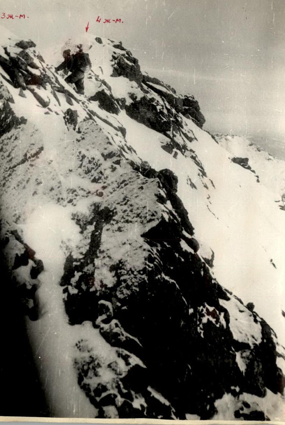
From the ridge, ascent to the sub-peak of peak 9 May (photo 13, 14) head-on along snow-covered slabs (50°) to a ledge, difficult climbing, 20 m, 2 pitons, handrails, pulling out the backpack. From it upwards to the left along snow-covered slabs (50°) to the saddle 1 rope, handrails, insurance through ledges and piton. Then along the saddle to the right (photo 13) 1 rope, alternate movement, along a snow-covered corner (50°) with good holds 15 m, insurance through ledges, and a gentle pre-summit ascent 20 m to the peak 9 May, simultaneous movement.
Section 6–7.
Descent from the peak along the middle talus (40°) to the saddle under the 3rd gendarme 50 m, simultaneous movement. Ascent to the gendarme head-on (photo 15) along snow-covered rocks (40°) 1 rope, insurance through ledges. Descent from the gendarme along a snowy gentle ridge to a large snowy plateau, simultaneous movement. We stopped for the night at 18:00 (photo 16), having spent 11 walking hours.
Section 7–8 (photo 17)
From the plateau, ascent to the 5th gendarme, simultaneous movement, along snow and easy gentle rocks 1 rope. We traverse under the peak of the gendarme to the right along snow and slabs (35°) to a ledge, 1 rope, 1 piton, handrails. Descent from the gendarme (photo 17) in sport style along smooth slabs (50°) on two ropes down to the right to a crevice above the couloir, handrails. From the crevice, descent into the couloir (50°). Movement along it is alternate 2 ropes (photo 18), insurance through ice axe. Then exit to a destroyed narrow ridge (photo 17). Along it 2 ropes, alternate movement, insurance through ledges (Loose rocks!). Then, having ascended to the ascent of the ridge (photo 17), we pass along it 2 ropes, and descend down to the right along snow and easy rocks (40°) 20 m, alternate insurance through ledges. We traverse along the rocks (photo 19) along a snowy slope (50°) on 3 ropes and exit to the ridge under the 6th gendarme, alternate movement, insurance through ice axe.
Section 8–9.
The 6th gendarme is taken head-on along snow-covered rocks (45°). At the top, there is a "ridge" 6 m (photo 20), movement upwards. Insurance through ledges, handrails. Descent from the gendarme along a snowy ledge to the right and snow-covered rocks (40°) 40 m to the saddle. Under the 7th gendarme, which is passed head-on along snow-covered rocks (45°) 15 m, insurance through ledges. Descent from the gendarme along slabs (75°) in sport style from a convenient ledge (photo 21) 45 m to the saddle. Then along a narrow jagged ridge to the end of the saddle 2 ropes, alternate insurance. (Loose rocks!). At the end of the saddle, rappel descent along the wall 10 m under the 8th gendarme (photo 22).
Section 9–10.
The 8th gendarme is taken head-on with the help of a "living ladder" along a smooth wall 3 m, with pulling out the backpack and along a snow-covered corner (40°) 25 m, 3 pitons, handrails (photo 23). Then we go around a large triangular stone to the right; then along snow-covered slabs (35°) and snow we ascend to the peak of the gendarme, 2 ropes, alternate insurance through ledges. On the ridge of the gendarme, movement is alternate on 3 ropes. Descent from the gendarme in sport style along slabs 20 m (photo 24) to the ridge.
Section 10–11.
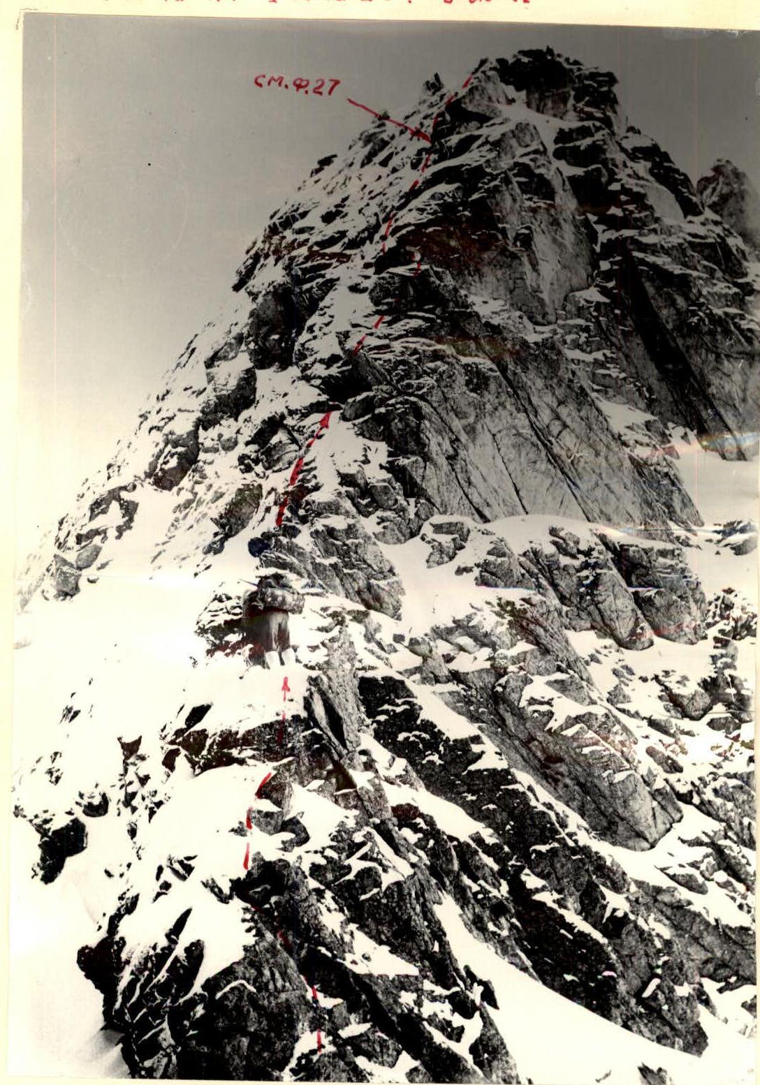
Movement along a narrow heavily jagged ridge (photo 25), 3 ropes of difficult climbing (Loose rocks!), alternate insurance through ledges. Ascent to the 9th gendarme head-on (photo 26, 27) along a snow-covered corner (50°) 1 rope, 2 pitons, handrails. Then – 1 rope to the left upwards along snow-covered slabs (60°) – difficult climbing, 2 pitons, handrails. Then along an inclined snow-covered slab, ascent to the peak of the gendarme (30°), 1 rope, handrails, insurance through ledges.
Section 11–12 (photo 31)
Then the movement is simultaneous and alternate – 5 ropes (photo 28, 29), easy climbing along snow-covered rocks (40°) to a niche in the 10th gendarme (photo 29). From the niche along a smooth 3-meter wall (photo 29) with the help of a "living" ladder to the left to a ledge, 2 pitons. From the ledge to the right upwards along a narrow edge (45°) to the peak of the gendarme, 1 rope, difficult climbing, 2 pitons (Loose rocks!). Descent from the gendarme along ledges alternately to the saddle 10 m under the 11th gendarme.
Section 12–13 (photo 31)
The 11th gendarme is passed head-on (photo 30) along a smooth 2-meter wall with the help of a "living" ladder and along an inclined snow-covered ledge (45°) with small holds to the right upwards 15 m, difficult climbing, 3 pitons, handrails, pulling out the backpack.
Then along snow-covered smooth rocks (35°):
- 1 rope of handrails
- insurance through ledges.
Then along a jagged ridge (35°) 4 ropes to the 12th gendarme "mirror" (photo 31-32). Easy climbing with simultaneous and alternate insurance.
The 12th gendarme is taken to the left along a snow-covered wall (55°) (photo 32):
- 1 rope
- 3 pitons
- handrails
Difficult climbing, pulling out the backpack.
Section 13–14.
Movement along a jagged destroyed ridge (photo 31) under the 13th gendarme. 1.5 ropes, alternate insurance. From the gendarme to the left down to a large flat stone – 1 rope. Overnight stay for one tent (photo 33). We stopped for the night at 19:00, having spent 12 walking hours.
The 13th gendarme is bypassed to the right along destroyed rocks – 1 rope to the couloir. Insurance through piton and ledges, handrails. Then along a snowy couloir (50°) (photo 34) – 1 rope to the ridge to the 14th gendarme, handrails. The ascent is easy, with alternate insurance.
From the gendarme, transition along the saddle (photo 35) (Be careful, cornice!). Ascent to the peak – along snow-covered slabs: 1 rope, 1 piton, handrails. We ascended to the peak at 11:00 (photo 36).
Section 14–15.
Descent from the North Tower v. Trehglavaya along the northern ridge along route 2B 5 hours (photo 1).
The route took 31 walking hours. The group believes that the route taken in these conditions corresponds to category 4A.
Group composition:
- NIKONOV V.P. – P r-d+4A+4B – leader.
- NIKOLAEVA I.M. – P r-d+4A+4B – participant.
- SAZANOV V.V. – P r-d+4A+4A – participant.
- VINOKUROV V.A. – P r-d+4A+4B – participant.
- ZARECHNIK I.P. – P r-d+4A+4A – participant.
- PUTILOV YU.P. – P r-d+4A+4A+4B – participant.
Recommendations:
Exit to the route for a group of no more than 4 people. Start the route in winter no later than 7:00.
RECOMMENDED EQUIPMENT:
- Rope 1 x 30 m, 1 x 40 m (for 4 people)
- Pitons, combined rock pitons 10 pcs.
- 2 rock hammers.
- Repschnur 30 m.
- Repschnur, expendable 10 m.
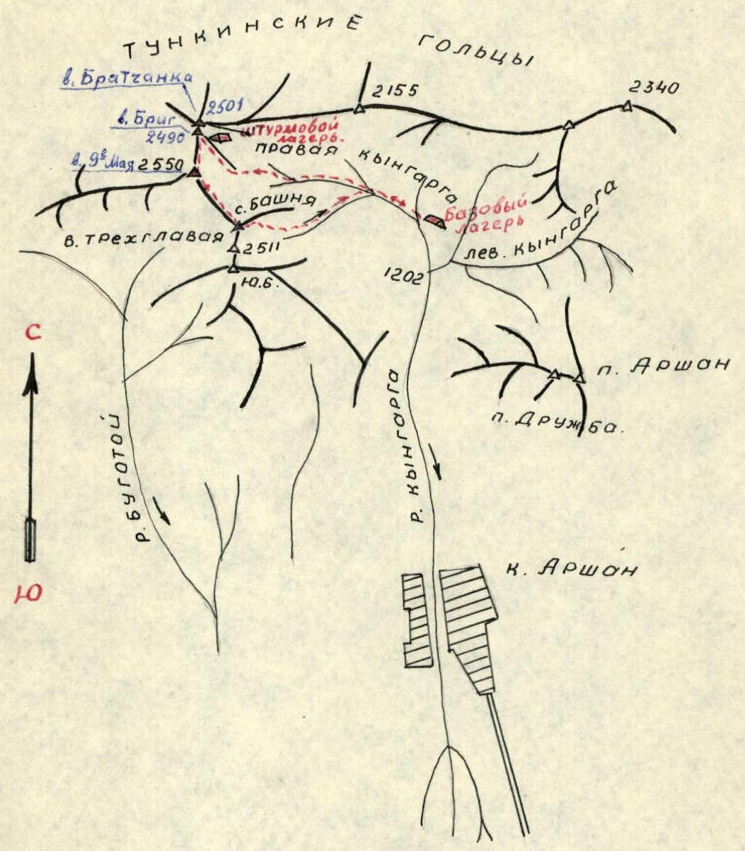
Table of main characteristics