ASCENT DOCUMENT
- Climbing category — rock climbing.
- Climbing area — Eastern Sayan, Tunka Goltsy ridge.
- Peak, its height, ascent route — Bashnya, 2800 m, via the eastern ridge.
- Proposed difficulty category — 2B, year-round.
- Height difference, average steepness — 170 m, 50°. Length of sections by category of difficulty: 1st category of difficulty — 130 m, 2nd category of difficulty — 40 m, 3rd category of difficulty — 35 m.
- Pitons hammered: for belay — 5 pcs., for I.T.O. —
- Number of walking hours — 2 hours.
- Number of nights and their characteristics — none.
- Full name of the leader, participants, and their qualifications: Belousov V.M. — CMS Petrasko G.A. — MS Taran N.V. — CMS Stanevich A.M. — CMS
- Team coach — Petrasko G.A.
- Date of ascent — May 6, 1981.
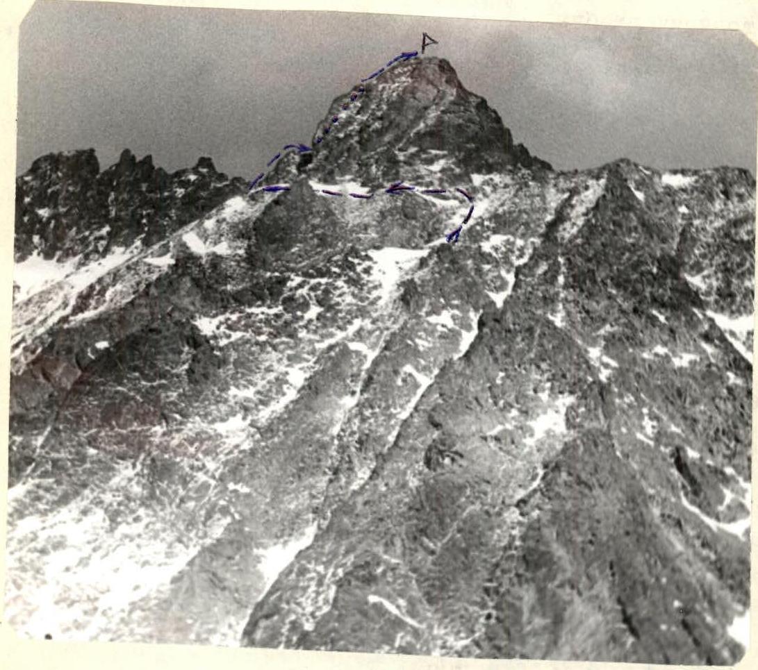
TABLE OF MAIN CHARACTERISTICS OF THE ASCENT ROUTE
| Date | Designation | Average steepness, degrees | Length, m | Relief characteristic | Difficulty | Condition | Weather conditions | Rock pitons | Ice pitons | Bolts | Note |
|---|---|---|---|---|---|---|---|---|---|---|---|
| May 6, 1981 | R0–R1 | 50 | 70 | Wide ridge | 1–2 | — | Fog, light snow | — | — | — | — |
| — | — | 0 | 20 | Ridge | — | — | — | — | — | — | — |
| — | R1–R2 | 65 | 30 | Wall | 2–3 | Monolithic rocks with good holds | Overcast | 1 | — | — | — |
| — | — | 70 | 25 | Wall | 3 | — | — | 4 | — | — | — |
| — | R2–R3 | 45 | 60 | Slope | 1 | Easy rocks | — | — | — | — | — |

EXPLANATION FOR THE TABLE OF MAIN CHARACTERISTICS OF THE ASCENT ROUTE
Approach — from the base camp on the forest border — to the western gentle shoulder of Bashnya peak, via the northwestern couloir from the SOAN peak cirque or along the right slope of the western couloir of Bashnya peak (from the Zun-Khandagai river valley).
To the left, along the talus shelf, bypassing the base of Bashnya peak (passing by the start of the route (2nd category of difficulty) along the northern counterfort). Descending slightly, enter via a short, easy couloir onto the saddle of the eastern ridge of Bashnya peak.
- 70 m — to the pre-summit shoulder of Bashnya peak — easy climbing on stepped rocks. Control cairn.
- 20 m — horizontal approach to the summit wall.
- 30 m — deviating to the right, along a crevice, easy and moderate climbing on blocky rocks. Good ledge.
- 25 m — moderately difficult climbing on steep rocks with good holds. At the top — caution! — loose rocks.
- 60 m — to the left along the ridge on easy rocks. Exit to the summit.
Descent along the southern ridge of the 1B category difficulty route.