TOWER (2800 m) via the South Ridge
Route: 1B category of difficulty
All-year-round
Geographical Location
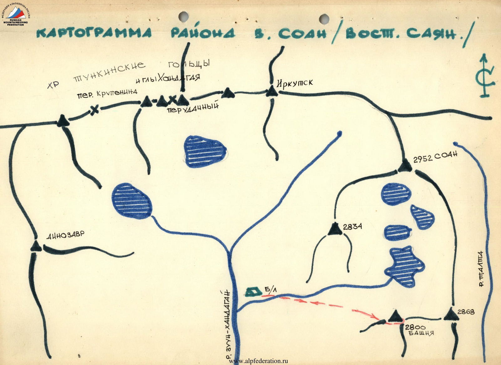
The Tower peak is located in one of the southern spurs of the main ridge of the Tunka Belki range in the Eastern Sayan Mountains, situated on the eastern side of the Zun-Khandagai River valley and closing off to the north with the SOAN peak (see diagram).
Access to the Base Camp
From Irkutsk, take a bus or drive to the Arshan resort - 218 km. From Arshan resort to the Zun-Khandagai River valley, west along the main ridge via the Tagarhoy village by car or on foot - 12 km.
Then, on foot, up the trail on the right side of the Zun-Khandagai River valley to the fork of the left and right Zun-Khandagai rivers - 9 km. The base camp is located at the fork. The forest boundary is here. Plenty of firewood.
Time breakdown: Irkutsk-Arshan - 7 hours by bus, Arshan-base camp - 2 days on foot.
Climatic Conditions
The ascent to the Tower peak was made in early May. The weather was sunny. The air temperature at the base camp level (1890 m) rose to +5°C during the day and dropped to -10°C at night.
On the approach to the base camp, there was no snow on the lower third of the trail. The remaining two-thirds of the route through the valley were snowy, and the upper part was icy. The snow was loose and deep, the ice was solid. The base camp area and above were completely snow-covered, the riverbeds were covered with ice and aufeis.
At night, a strong wind blew down the valley.
Route Description
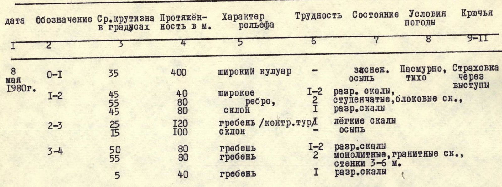
To the Tower peak via the south ridge. The peak height is 2800 m. Estimated category of difficulty - 1B all-year-round. Ascent time on May 3, 1975.
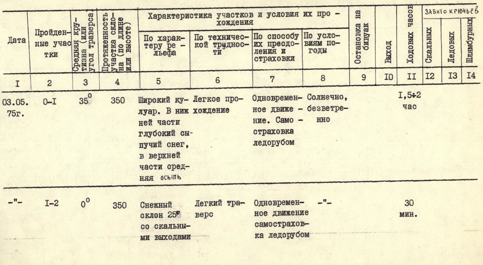
Table of main route characteristics
Climbing event: sports gathering of the Irkutsk Regional Alpine Federation.
Group composition:
- Belousov V.M. - CMS
- Vorobieva N.N. - 1st sports category
- Kharlamov S.M. - 2nd sports category
- Tsiomik A.L. - 2nd sports category
- Bryansky V.P. - 1st sports category
- Shishkin V.I. - 1st sports category
Approach to the Route Start
From the base camp, up the left Zun-Khandagai River through I+II, 54, we approach the start of the route - a wide northwest couloir descending from the western shoulder of the Tower peak.
Section R0–R1 (photo № 1)
The ascent up the couloir to the western shoulder takes 1.5-2 hours. The couloir steepness is 35°, the length is 350 m.
The couloir is filled with deep snow, with firn areas in places. The lower part of the couloir becomes more gentle. In the upper part of the couloir, there is little snow, and medium-sized rocks protrude.
The couloir leads to a wide western shoulder (a "goat pasture").
Section R1–R2 (photo № 2)
From the western shoulder, traverse left without gaining height along the slope with a steepness of 25° under the Tower wall towards the Zub. Zub is a separate monolithic rock, 30 m high, standing in the lower part of the south edge of the Tower peak. The section length is 350 m, ending 30-40 m short of Zub. It is traversed simultaneously along the boundary of snowy slopes and rocks, with self-arrest using an ice axe. Time taken: 20-30 minutes.
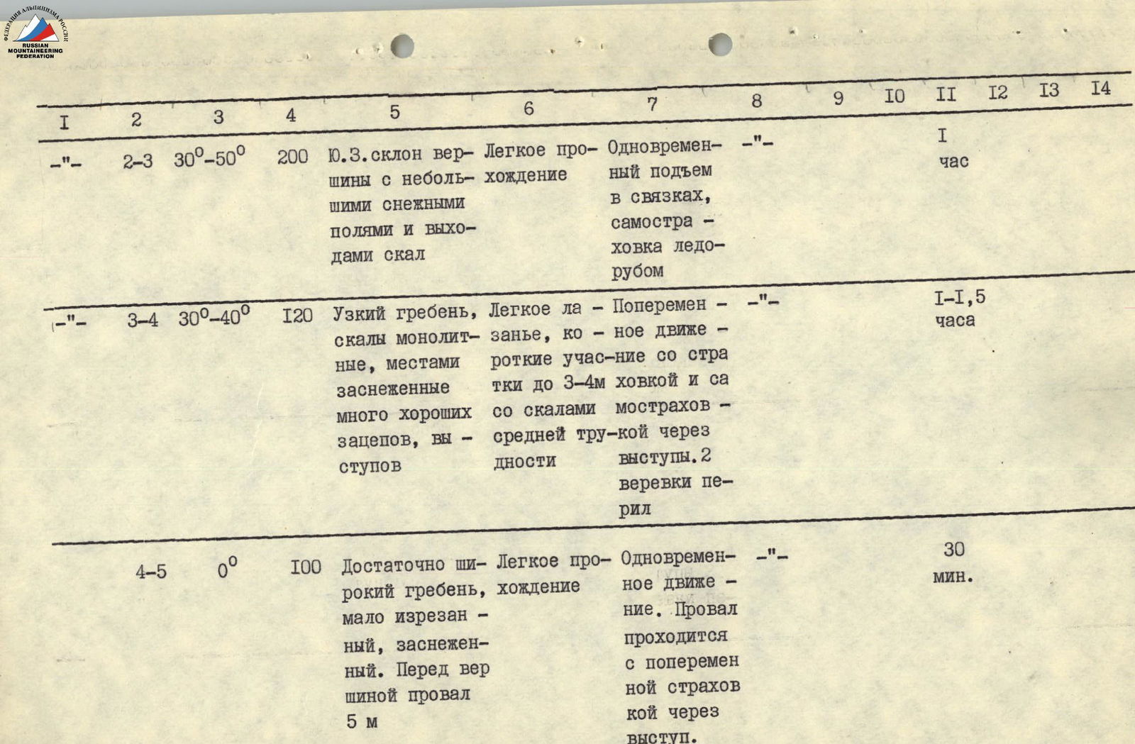
Section R2–R3 (photo № 3, 4)
Up the couloir for 25 m and then left for 120 m with a gain in height along the southwest slope of the peak to a small shoulder, from which the couloir descending from the peak is visible. From the shoulder, one rope length up to the right through snowy rocks - exit to the south ridge of the peak. Average slope steepness is 40°, snow is deep and loose. Movement is simultaneous in rope teams, with self-arrest using an ice axe. The section takes 1 hour.
Section R3–R4 (photo № 4)
The route follows strictly along the south ridge. The length is 120 m. Overall steepness is 30-40°. The ridge is narrow, dropping off to the right with a wall and transitioning to the southwest slope with a steepness of up to 70° on the left. The rocks are monolithic, easy to medium difficulty. Individual short rock outcrops reach steepness of 60-70°. Protection is alternating through outcrops or by setting up belays. The section takes 1-1.5 hours.
Section R4–R5 (photo № 4)
A horizontal section of the ridge, 100 m long. It is wide enough to be traversed simultaneously. The ridge ends with a slight rise, which is the peak.
On the ridge, before the peak, there is a 5 m deep gap. To pass the gap:
- with alternating protection to the left along a ledge under an overhanging rock;
- exit through a window formed by a detached "Pen";
- from the window, straight up to the peak.
Time taken for the section: 20-30 minutes.
The ascent to the peak takes 4-5.5 hours.
The descent along the ascent route to the base camp takes 3-4 hours.
The group believes that the route to the Tower peak via the south ridge corresponds to the 1B category of difficulty all-year-round.


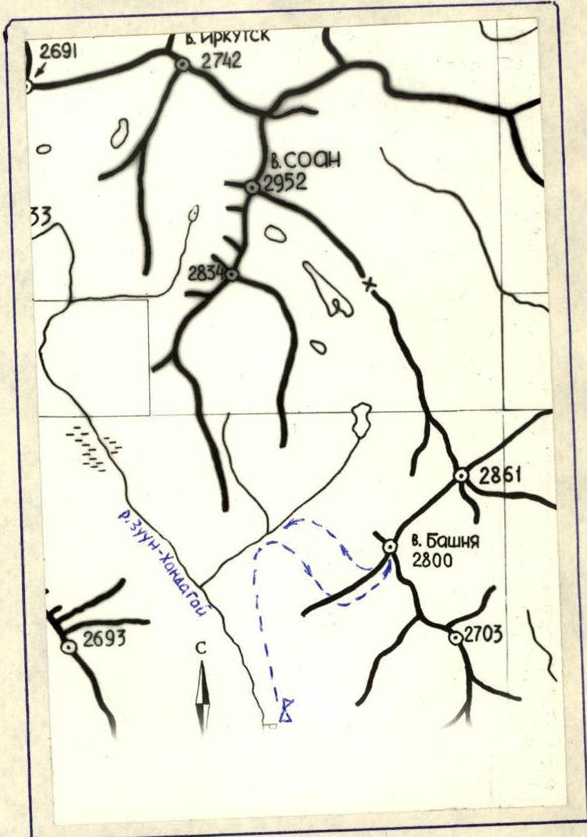 TABLE OF MAIN CHARACTERISTICS OF THE ASCENT ROUTE TO THE TOWER PEAK
Description of the Approach to the Route and Brief Explanation of the Table
From the base camp at the forest boundary, up into the first right-hand side valley (SOAN peak valley).
Entering the valley along the left-hand (orographic) pillow with large-block talus, go above the valley stream. After 150 m, at the base of the talus - to the cairn above the stream, ascend up the talus and then up to the right - into a wide couloir.
Up the couloir - 400 m - to the narrowing of the couloir. Up the wide ridge dividing the upper couloir. After 4 rope lengths of easy climbing, exit onto the ridge (control cairn), then - after 3 rope lengths - exit to the sub-peak. 100 m - transition under rocks to the D-3 ridge of the Tower peak. Along it - 2 rope lengths of easy rocks, then 2 rope lengths of more difficult rocks, with walls 3-6 m. The final easy rope length to the peak - with a gap in the ridge.
Descent:
- along the ascent route, with one sports descent;
- from the sub-peak - to the right, into the couloir, down it to the stream.