Report
On the first ascent of Peak 4971 via the central counterfort of the eastern ridge, category 5A
South-West Pamir, Northern Shugnanskiy ridge, a/l "Varzob"
Veselov A. N. Kostrichenko V. V.
1978
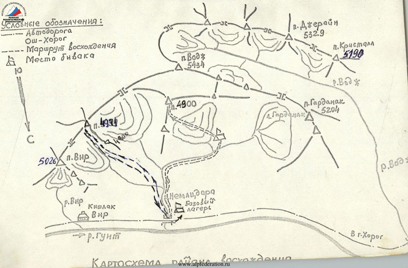
Map of the ascent area
Conventions:
- Osh-Khorog highway
- Ascent route
- Bivouac site
S
p. Vir (5026 m)
p. 4934
p. Vodzh (5434 m)
p. 4900
p. Dzherayn (5329 m)
p. Crystal (5190 m)
p. Gardanak (5204 m)
Base camp "Nematzdara"
Vir village
r. Vir
r. Gunt
r. VDzh
To Khorog
r. VDv
Appendix No. 2
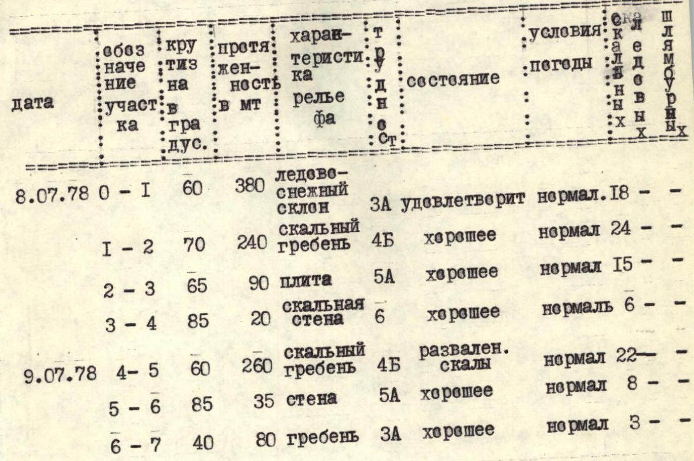
Table of main characteristics of the ascent route to Peak 4971 via the eastern ridge, category 5A
| Date | Section | Slope | Length, m | Relief characteristics | Difficulty | Condition | Weather conditions | Rock pitons | Ice screws | Bolt pitons |
|---|---|---|---|---|---|---|---|---|---|---|
| 08.07.1978 | R0–R1 | 60° | 380 | Snow-ice slope | 3 | Satisfactory | Normal | 18 | 0 | 0 |
| R1–R2 | 70° | 240 | Rocky ridge | 4 | Good | Normal | 24 | 0 | 0 | |
| R2–R3 | 65° | 90 | Slab | 5 | Good | Normal | 15 | 0 | 0 | |
| R3–R4 | 85° | 20 | Rocky wall | 6 | Good | Normal | 6 | 0 | 0 | |
| 09.07.1978 | R4–R5 | 60° | 260 | Rocky ridge | 4 | Broken rocks | Normal | 22 | 0 | 0 |
| R5–R6 | 85° | 35 | Wall | 5 | Good | Normal | 8 | 0 | 0 | |
| R6–R7 | 40° | 80 | Ridge | 3 | Good | Normal | 3 | 0 | 0 |
Start of the route - July 8, 1978 at 5:00 Reach the summit - July 9, 1978 at 15:00 Total travel time - 21 hours Descent time - 6 hours
Pitons used for belaying:
- Rock pitons - 96
- For creating artificial holds - 6
- Ice screws - 0
- Bolt pitons - 0
The table is compiled based on the Regulations on the classification of routes.
Brief description of the approach to the route
Peak 4971 is located in the north-eastern spur of Vir peak, which is in the Northern Shugnanskiy ridge (South-West Pamir).
The approach to the route is made from the base camp. The camp is located near the Khorog-Osh road (59 km from Khorog) by the Gunt river. There are sources of drinking water. Nearby are the villages of Vir and Shtam. Thanks to the road, there are conditions for communication with both Khorog and Osh.
From the base camp on the left bank of the Gunt river towards the Vir village to the gorge between p. Vir and p. 4971, then along the trail towards the saddle, then along the moraine under the route - 4 hours 30 minutes. Here is a good place for an overnight stay. There are flat safe areas. There is drinking water.
Explanation for the table
Peak 4971 is located in the Northern Shugnanskiy ridge. The route is a combined rock and snow route. The beginning of the route is along a firn-ice couloir at 60°. Then there is an exit to the eastern ridge, which leads to the summit of p. 4971.
By its nature, the entire route can be divided into the following sections:
- R0–R1 - Ice slope
- R1–R2 - Rocky ridge. Wall with streaks
- R2–R3 - Wall with streaks. Ridge
- R3–R4 - 20-meter wall
- R4–R5 - Rocky ridge
- R5–R6 - Ridge, summit tower
- R6–R7 - Summit ascent
Description of the route
R0–R1. The overnight stay is located on the moraine opposite the eastern ridge. From the overnight stay in the direction of the eastern ridge (2nd from the saddle between p. Vir and p. 4971) along a snowy couloir at 60° along the border of snow (firn) and rocks - 380 m. Belaying is done with rock pitons into the rocks. The couloir should be traversed as early as possible, around 8:00; stones sometimes fall from the adjacent ridge.
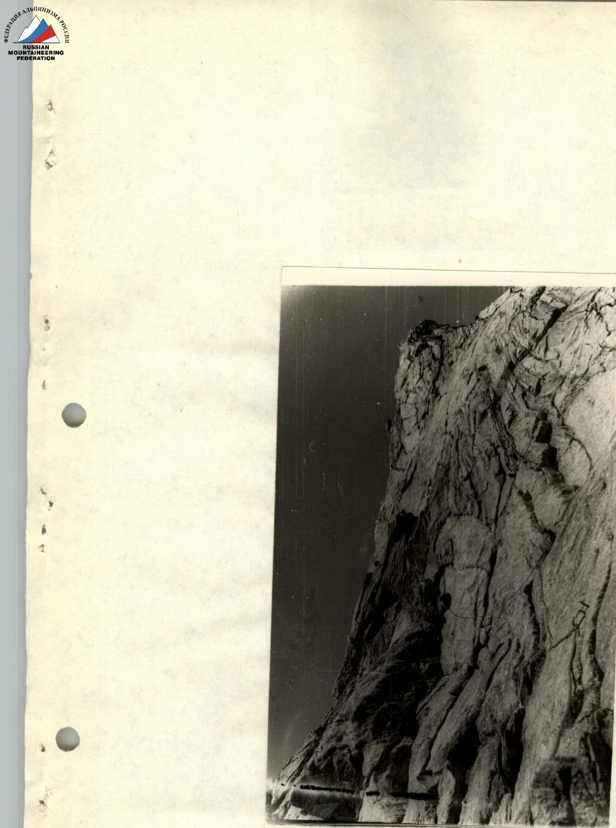
R1–R2. Further exit to the eastern ridge, rocks of medium difficulty, piton belaying, alternating climbing. And further along the ridge to the wall with black streaks. The steepness of the rocks is 70°.
R2–R3. The wall is bypassed on the right - 2.5 ropes, 90 meters of complex climbing, exit to the ridge. Here the ridge becomes gentler. There are areas for an overnight stay. Further along the ridge leads to under the 20-meter rocky wall.
R3–R4. The rocky wall is climbed directly with the use of artificial holds. Climbing is complex. Belaying is with rock pitons. It's best to use wedges and " закладки". There's a cairn and an overnight stay site at the top.
R4–R5. July 9, 1978. Further from the overnight stay along the ridge towards the summit tower. The ridge is destroyed. There are loose stones. Climbing along the ridge is of medium complexity. Steepness is 60°–70°. Belaying is done through ledges and "закладками". Along the ridge - 240 meters, a smooth exit under the summit tower.
R5–R6. The tower is climbed directly. Steepness is 90°. Climbing is complex. Belaying is with wedges or ice screws.
R6–R7. Exit to the summit. The summit is a sharp peak. Descent from the summit to the saddle towards the lake along the route of category 3A, then along the ridge with talus shelves to the snowfields and along them to the lake and further to the saddle and to the overnight stay site.
The descent from the summit to the saddle takes 1.5-2 hours, from the saddle to the overnight stay - 1 hour. From the overnight stay site to the base camp - 3 hours.
Section R1–R2
Appendix No. 1
Ascent passport
- Ascent class: technical
- Ascent area: South-West Pamir, Northern Shugnanskiy ridge
- Peak, its height, ascent route: Peak 4971 via the central counterfort of the eastern ridge
- Proposed category of difficulty: category 5A
- Route characteristics:
- Height difference: 750 m
- Length of sections: 5-6 category of difficulty
- 3 (category of difficulty) - 380 m
- 4 (category of difficulty) - 280 m
- 6 (category of difficulty) - 540 m
- 6 (category of difficulty) - 40 m
- Average steepness: 60°
- Pitons used:
- For belaying:
- Rock pitons - 80
- Ice screws - 0
- Bolt pitons - 5
- For creating artificial holds: 5
- For belaying:
- Number of travel hours: 15
- Number of overnight stays and their characteristics: (data not available)
- Surname, name, patronymic of the leader, participants and their qualification:
- Sentsov Sergey Konstantinovich - 1st sports category
- Kruglenko Alexander Vasilievich - Candidate Master of Sports
- Frolov Semen Konstantinovich - 1st sports category
- Team coach: Kensitskiy Leopold Vsevolodovich
- Date of departure and return: July 9, 1978
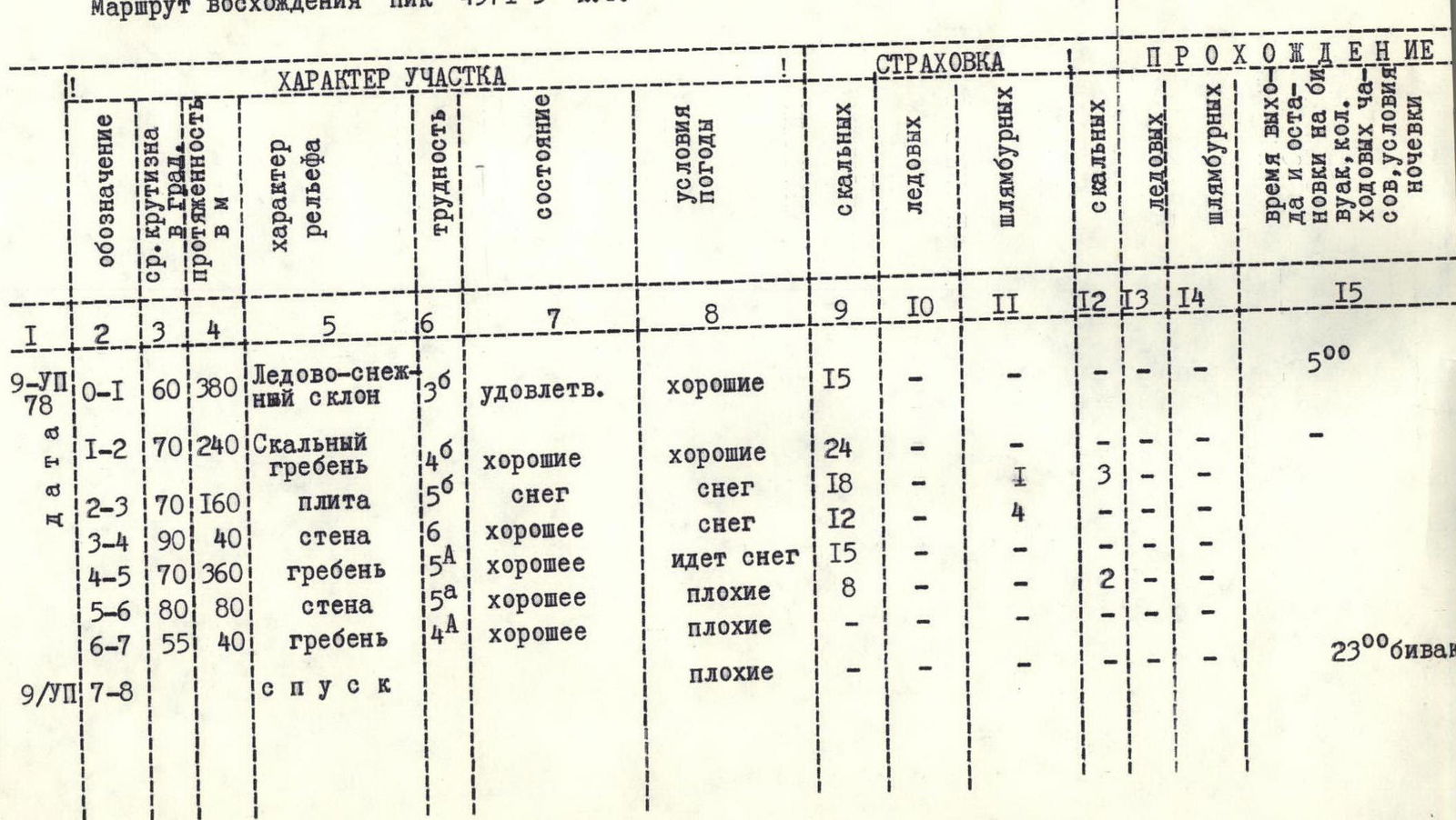
Table No. 1
Table of main characteristics of the ascent route
Ascent route: Peak 4971, category 5A
| Date | Designation | Average steepness | Length, m | Relief characteristics | Difficulty | Condition | Weather conditions | Rock pitons | Ice screws | Bolt pitons | Passage | Time of departure, h | Number of travel hours | Number of overnight stays |
|---|---|---|---|---|---|---|---|---|---|---|---|---|---|---|
| 09.07.1978 | R0–R1 | 60 | 380 | Snow-ice slope | 3 | Satisfactory | Good | 15 | – | – | – | 5:00 | – | – |
| R1–R2 | 70 | 240 | Rocky ridge | 4 | Good | Good | 24 | – | – | – | – | – | – | |
| R2–R3 | 70 | 160 | Slab | 5 | Good | Snow | 18 | – | 1 | 3 | – | – | – | |
| R3–R4 | 90 | 40 | Wall | 6 | Good | Snow | 12 | – | 4 | – | – | – | – | |
| R4–R5 | 70 | 360 | Ridge | 5 | Good | Snowing | 15 | – | – | 2 | – | – | – | |
| R5–R6 | 80 | 80 | Wall | 5 | Good | Bad | 8 | – | – | – | – | – | – | |
| R6–R7 | 55 | 40 | Ridge | 4 | Good | Bad | – | – | – | – | – | – | – | |
| 09.07.1978 | Descent | Bad | – | – | – | – | 23:00 | – | Bivouac |
PROTOCOL No. 14 July 12, 1978 a/l "Varzob"
Debriefing of the ascent of Peak 4971 via the central counterfort of the eastern ridge, category 5A, by a group consisting of:
- Sentsov S. K. - leader
- Kruglenko A. V. - participant
- Frolov S. K. - participant
Observers: Veselov A. N., Kostrichenko V. V. Debriefing conducted by 1st release Kensitskiy L. V.
Heard: Sentsov S. K. - On July 9, 1978, at 5:00 the group started the route. The beginning is along a steep snow slope, then along rocks to the counterfort. They approached the black wall (a good landmark on the route). The wall is bypassed on the left along rocks for 120 m. 40 m of complex climbing - piton belaying. After bypassing the wall, there is an exit to the ridge. Movement along the ridge with piton belaying (mainly channel and закладки pitons). The ridge leads to a 20-25 m wall with a steepness of 90°. The wall is climbed directly on artificial holds. At 13:00, snow started. It's hard to move, the rocks are wet, and it's cold. At 17:00, they rested and changed clothes. Then along the ridge of 4th category of difficulty with piton belaying. At 20:00, they reached the summit. Following the tracks of a previously passed group, they began descending to the large snowfields in the direction of the lake. At 22:30, they descended to the lake, and 30 minutes later they were at the bivouac.
Recommendations:
- Depart no later than 5:00, as stone and ice falls were observed on the first wall.
- It is mandatory to take two ice axes for a group of 4 people.
The group spent 15 travel hours on the ascent.
Kensitskiy: "Route length by ropes?" Sentsov: "400 m along snow, 18 × 40 m along rocks, 3 × 40 m combined".
Kensitskiy: "Number of pitons used for belaying and reception?" Sentsov: "For belaying - 60 pieces. For reception and gathering of the group - 25 pieces. In many places, belaying for reception was done through ledges and stones. Total of 85 pitons".
DECIDED: The ascent and leadership are recognized.
First release L. V. Kensitskiy