
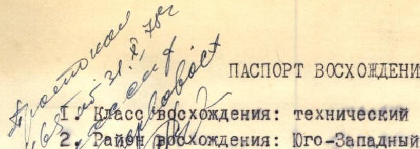
- Peak, its height, ascent route: p. 4800 m via N wall
- Estimated difficulty category: 5B
- Route characteristics:
Height difference — 950 m, length of sections: 4th cat. diff. — 505 m; 5th cat. diff. — 275 m; 6th cat. diff. — 318 m. Average steepness of the route 71°, steepness of the defining part (sections R1 + R16) — 78°.
Pitons hammered in
For belaying: rock — 82, ice (into rocks) — 22, bolt — 8, placed — 37.
For creating ITO (Intermediate Technical Objects):
| Rock | — | 8 |
| Ice | — | 2 |
| Bolt | — | 1 |
| Placed | — | 5 |
- Number of climbing hours — 24 h 30 min.
- Number of bivouacs and their characteristics: 3 bivouacs, ledges for 1 person, 50–60 cm wide.
- Leader of the ascent — A.M. Stavnitser, Candidate for Master of Sports, instructor.
Ascent participants:
- V.R. Bovkun, 1st sports category
- V.V. Zasypkin, Candidate for Master of Sports, instructor
- A.A. Samoded, Master of Sports, instructor
-
Team coach: L.V. Kensitsky, Master of Sports, senior instructor.
-
Date of departure and return: July 23 – July 26, 1978.
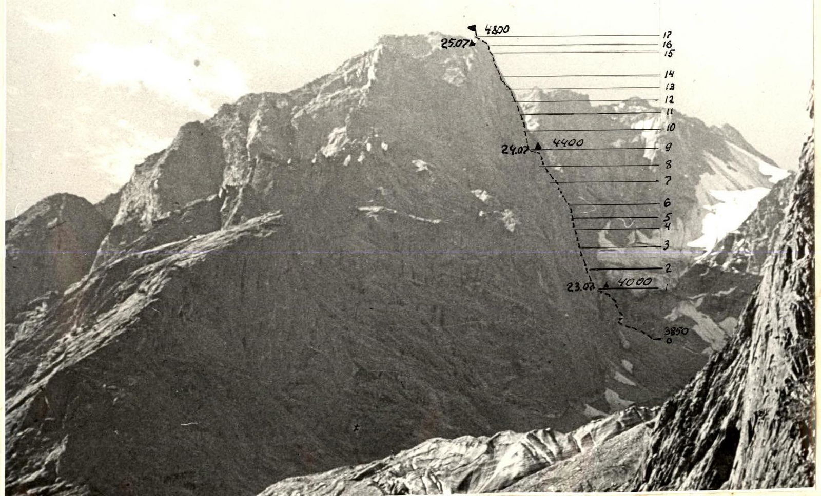
General view of Peak 4800 m from the Vodzh River valley.
Brief description of the approach to the route
The approach to the route starts from the 49/687 km post on the Khorog — Osh highway from the settlement of VUZh towards the peak of characteristic trapezoidal shape, clearly visible from the highway. Moving orographically along the left bank of the Vodzh-Dara River, we cross several streams flowing from the glacier. From the highway to the glacier tongue — 1.5–2 hours.
We go around the glacier tongue from the left and, moving along the middle scree between the walls of the "trapezoid" and the right lateral moraine of the glacier (and in June — on snow), sometimes approaching the walls of the "trapezoid" closely, we ascend to a bivouac on the scree under the North wall.
From the glacier tongue 2–2.5 hours. A short steep counterfort leads to the wall part of the route; it is not recommended to bypass it to the right due to frequent rockfalls and ice avalanches from the "hanging" glacier.
Brief explanation for the table of main route characteristics
On July 23 at 8:00 we leave the camp above the Vodzh village. At 12:00 we approach the route, at 12:30 we start working. Slab section — 240 m, we complete it by 16:00.
The Stavnitser — Samoded rope starts processing the steep wall cut by a vertical chimney up to 200 m long. The chimney:
- is twice closed by overhanging plugs,
- in the third quarter leads to a cornice with an overhang of up to one and a half meters.
120 m processed.
July 24 We start working at 8:30. Moving with a backpack in the chimney is very inconvenient. We use different techniques for pulling up backpacks. The cornice is passed "head-on" to the right of the direction, the plugs are bypassed to the right along sections of steep and overhanging wall. Climbing is difficult; various placed pitons work well.
After the chimney, the wall becomes less steep, it is dominated by a large-block structure, then there are sections of destroyed rocks.
After the destroyed rocks, a monolithic wall with a slight undercut in the upper part leads to the bivouac site. Narrow, short ledges for 1 person. We process one and a half ropes of the wall.
July 25 The first rope starts the ascent at 8:00. It's cold on the wall. Very difficult sections, several small cornices, feathers. Rocks are strong. The steep monolith is replaced by less steep destroyed sections leading to the ridge. On the opposite slope of the ridge, there are excellent bivouac sites.
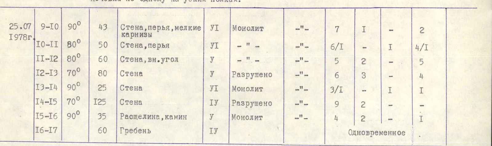
Table of main characteristics of the ascent route
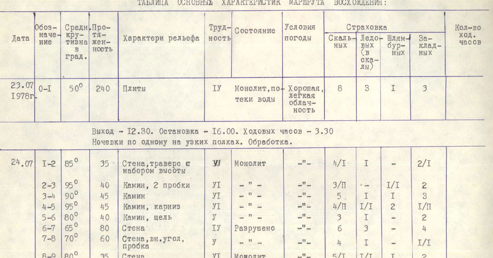
| Date | Designation | Average steepness in degrees | Length | Relief characteristic | Difficulty | State | Weather conditions | Rock | Ice (into rocks) | Bolt | Placed | Climbing hours |
|---|---|---|---|---|---|---|---|---|---|---|---|---|
| July 23, 1978 | R0–R1 | 50° | 240 m | Slabs | 1 | Monolith, water flow | Good, light cloudiness | 8 | 3 | 1 | 3 | |
| July 24 | R1–R2 | 85° | 35 m | Wall, traverse with height gain | 1 | Monolith | — | 4/1 | 1 | — | 2/1 | |
| R2–R3 | 95° | 40 m | Chimney, 2 plugs | 6 | — | — | 3/1 | 1/1 | 2 | |||
| R3–R4 | 90° | 45 m | Chimney | 6 | — | — | 5 | 1 | 1 | 3 | ||
| R4–R5 | 95° | 45 m | Chimney, cornice | 6 | — | — | 4/1 | 1/1 | 2 | 1/1 | ||
| R5–R6 | 80° | 40 m | Chimney, crack | 1 | — | — | 3 | 1 | — | 2 | ||
| R6–R7 | 65° | 80 m | Wall | 1 | Destroyed | — | 6 | 3 | — | 4 | ||
| R7–R8 | 70° | 60 m | Wall, internal angle, plug | 1 | — | — | 4 | — | 1 | 1/1 | ||
| R8–R9 | 80° | 35 m | Wall | 6 | Monolith | — | 5/1 | 1/1 | 1 | 2 | ||
| July 25, 1978 | R9–R10 | 90° | 43 m | Wall, feathers, small cornices | 6 | Monolith | — | 7 | 1 | — | 2 | |
| R10–R11 | 80° | 50 m | Wall, feathers | 6 | — | — | 6/1 | 1 | — | 4/1 | ||
| R11–R12 | 80° | 60 m | Wall, internal angle | 1 | — | — | 5 | 2 | — | 5 | ||
| R12–R13 | 70° | 80 m | Wall | 1 | Destroyed | — | 6 | 3 | — | 4 | ||
| R13–R14 | 90° | 25 m | Wall | 6 | Monolith | — | 3/1 | 1 | — | 1 | ||
| R14–R15 | 70° | 125 m | Wall | 1 | Destroyed | — | 9 | 2 | — | — | ||
| R15–R16 | 90° | 35 m | Crevice, chimney | 1 | Monolith | — | 4 | 2 | — | 1 | ||
| R16–R17 | 60 m | Ridge | 1 | Simultaneous |
Departure — 12:30; stop — 16:00; climbing hours — 3 h 30 min. Bivouacs for one person on narrow ledges.
Departure at 8:30; stop — 19:30; climbing hours — 10. Bivouac for one person on narrow ledges. Departure – 8:00; stop – 20:00; climbing hours – 11. Bivouac on the ridge below the summit, good site. The table does not include the time for preliminary processing of difficult sections, carried out on July 23 and 24, including preparation, etc. — 30 min.