4.13.136
SOUTHWESTERN PAMIR NORTH SHUGNAN RANGE Peak 40 let Chelyabinskogo politekhnicheskogo instituta im. Leninskogo komsomola (5070)
First ascent route, category 3B, via the N wall, ice and snow.
KARPENKOV M.V., SITCHIKHIN YU.V., SMIRNOV M.G., VAKHITOV T.K. August 16, 1983 450 m, 45°, III, 220/II, 160/16, 28 rope ladders 6 hours
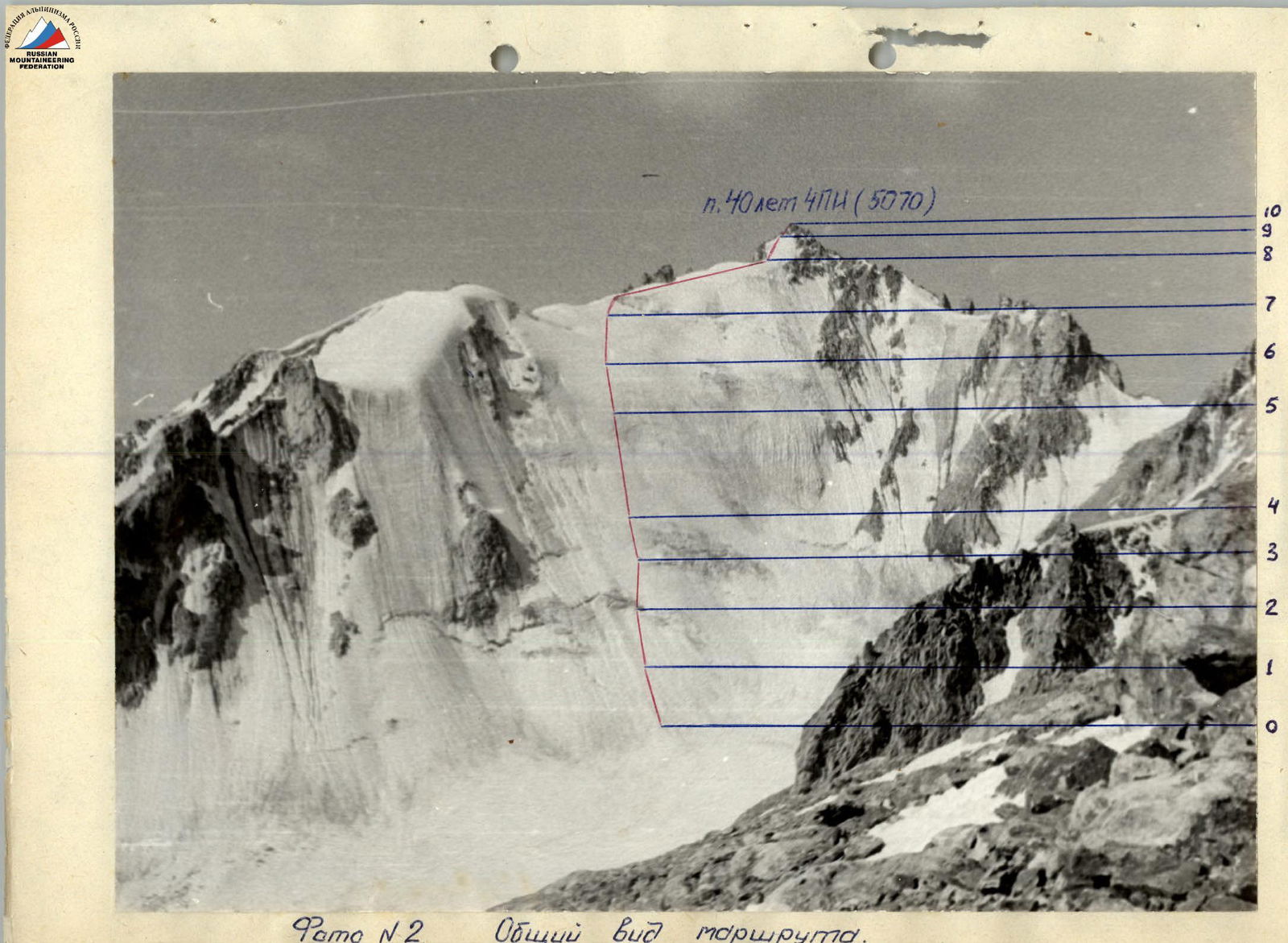
Photo # 2. General view of the route.
Brief Description of the Approach
To the Route
By car from Osh along the Pamir Highway, pass Vir settlement and at the 58th km (counting from Khorog) on the left side in an willow grove is the base camp.
The assault camp "4300" is located on the right (orographically) side of the Vodzh Severny glacier under the saddle between Peak 4971 and Peak Vodzh. The approach from the base camp to camp "4300" takes 4 hours.
From here, the approach to the route takes 2 hours. From camp "4300" along the right-hand (orographically) moraine of the glacier and on snow, ascend to the saddle between Peak 4971 and Peak Vodzh, and then exit onto the saddle. From the saddle, without gaining height, move along the southern slope of Peak Vodzh in a southwest direction. A slight descent and exit onto the glacier flowing from the cirque between Peak 40 let ChPI and Peak Vodzh. From here, the ice wall of Peak 40 let ChPI is visible.
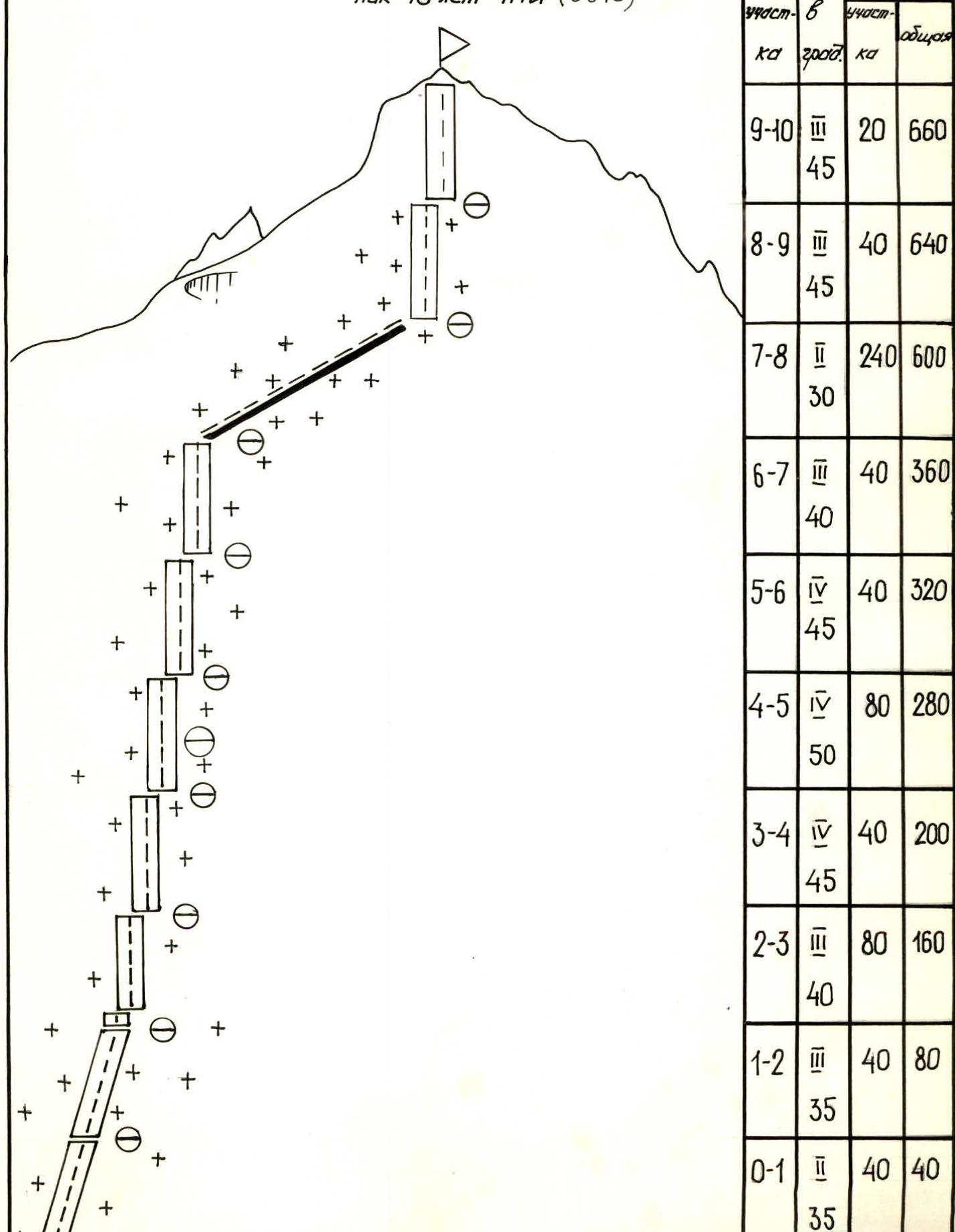
| Date, time | Designations | Average steepness, degrees | Length, m | Terrain characteristics | Difficulty | Condition | Weather | Rock | Ice | Notes |
|---|---|---|---|---|---|---|---|---|---|---|
| August 16, 1983, 10:00–16:00 | ||||||||||
| 6 hours of climbing | R0–R1 | 35 | 40 | snow slope | 2 | soft deep snow | clear, sunny | – | – | |
| R1–R2 | 35 | 40 | snow slope | 3 | dense snow | – | – | – | ||
| R2–R3 | 40 | 80 | snow-ice wall, serac | 3 | ice covered with a thin layer of snow | – | – | 7 | ||
| R3–R4 | 45 | 40 | ice wall | 4 | porous ice | – | – | 5 | ||
| R4–R5 | 50 | 80 | ice wall | 4 | porous ice | – | – | 10 | ||
| R5–R6 | 45 | 40 | snow-ice wall | 4 | ice covered with a thin layer of snow | – | – | 4 | ||
| R6–R7 | 40 | 40 | snow-ice wall | 3 | ice covered with a thin layer of snow | – | 2 | – | ||
| R7–R8 | 30 | 240 | snow ridge | 2 | deep soft snow | – | – | – | ||
| R8–R9 | 45 | 40 | snow wall | 3 | deep soft snow | – | – | – | ||
| R9–R10 | 45 | 20 | summit rock tower | 3 | destroyed rocks | – | – | – | Summit cairn |
Descent via the North Ridge to the saddle between Peak 40 let ChPI and Peak Vodzh. 1 rappel was organized on the descent. The descent took 2 hours.