- Climbing category: technical.
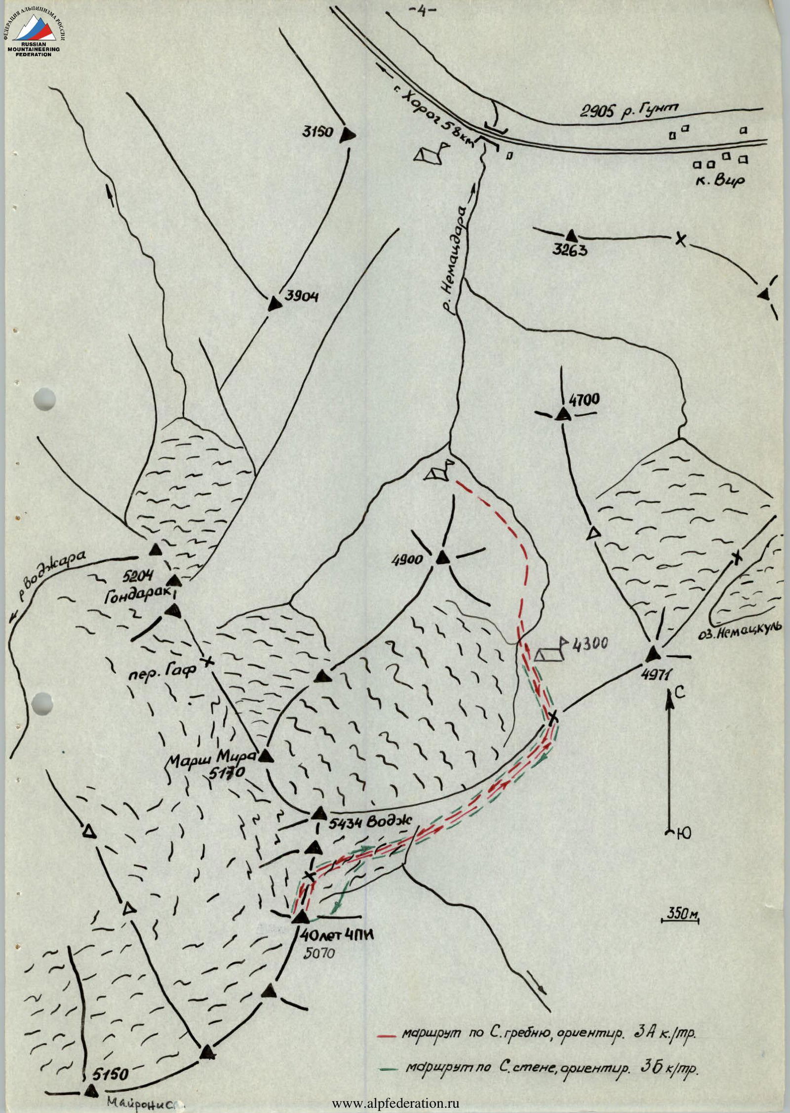
- Climbing area: South-Western Pamir; ridge: North-Shugnan.
- Peak: 40 years of Chelyabinsk Polytechnic Institute named after Lenin Komsomol; height: 5070 m; ascent route: along the northern ridge.
- Route characteristics: height difference — 380 m, length of sections 2nd cat. diff. — 570 m, 3rd cat. diff. — 105 m, 4th cat. diff. — 35 m, average steepness — 35°.
- Estimated difficulty category of the route: 3A, 25 combined.
- Pitons driven:
for belay for ITO rock 11 0 ice 3 0 bolt 0 0 - Number of walking hours: 7 hours.
- Number of overnight stays and their characteristics: no overnight stays.
- Surname, name, patronymic of participants and their qualification:
- Poludov Sergey Andreevich, 1st sports category
- Bochkov Vladimir Viktorovich, 1st sports category.
- Team coach: Ryabukhin Alexander Grigorievich, Honored Coach of the RSFSR.
- Date of departure and return: August 15, 1983.
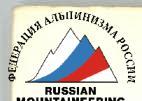
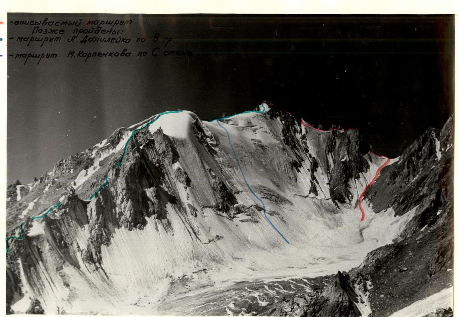

 Photo #1. General view of the peak, Peak 40 years of ChPI.
- route along the N ridge, estimated 3A cat. diff.
- route along the N wall, estimated 3B cat. diff.
Brief description of the approach to the route.
By car from Osh along the Pamir Highway, pass the village Vir and at 58 km (counting from Khorog) on the left side along the way in the Willow grove is the base camp.
The assault camp "4300" is located on the right (orographically) side of the Vodj Severny glacier under the saddle between peak 4971 and peak Vodj. The approach from the base camp to camp "4300" takes 4 hours.
From here, the approach to the route takes 2.5 hours: from camp "4300" along the right-hand (orographically) moraine of the glacier and snow ascent to the saddle between peak 4971 and peak Vodj, and then exit to the saddle. From the saddle without gaining height, move along the southern slope of peak Vodj in a southwesterly direction.
A slight descent and exit to the glacier flowing out of the cirque between peak 40 years of ChPI and peak Vodj. Then move to the saddle between peak 40 years of ChPI and peak Vodj.
Route diagram
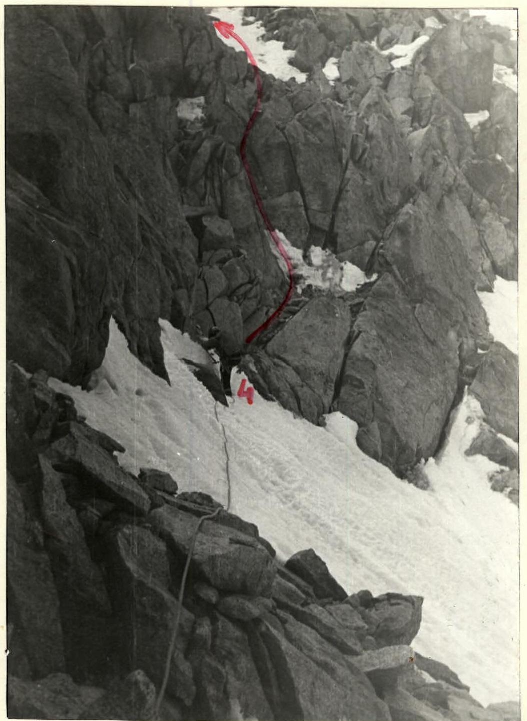
Photo #3. Section R3–R4 and beginning of section R4–R5.
TABLE OF MAIN CHARACTERISTICS OF THE ASCENT ROUTE
August 15, 1983 Walking hours — 5
| Date | Designation | Average steepness, ° | Length, m | Terrain characteristics | Difficulty | Condition | Weather conditions | Pitons: Rock | Pitons: Ice | Pitons: Bolt | Note |
|---|---|---|---|---|---|---|---|---|---|---|---|
| R0–R1 | 30 | 220 | Slope | 2 | Firm firn (rockfall hazard) | - | - | - | |||
| R1–R2 | 40 | 40 | Slope, cornice | 3 | Ice covered with a thin layer of snow, cornice soft, deep snow | - | 3 | - | |||
| R2–R3 | 15 | 40 | Ridge | 2 | Soft snow | - | - | - | |||
| R3–R4 | 35 | 40 | Ledge | 2 | Firm firn | - | - | - | |||
| R4–R5 | 70 | 20 | Internal angle | 4 | Rocky, monolithic | 3 | - | - | |||
| R5–R6 | 30 | 20 | Ledge | 2 | Rocky, monolithic | clear sky | 3 | - | - | ||
| R6–R7 | 60 | 15 | Wall | 4 | Rocky, monolithic | 3 | - | - | |||
| R7–R8 | 50 | 40 | Wall | 3 | Slightly destroyed rocks | 1 | - | - | |||
| R8–R9 | 30 | 60 | Ridge | 2 | Rocky, large-block | - | - | ||||
| R9–R10 | 40 | 40 | Ridge | 2 | Soft firn | - | - | - | |||
| R10–R11 | 30 | 50 | Ridge | 2 | Rocky, snow-covered, slightly destroyed | - | - | ||||
| R11–R12 | 45 | 25 | Wall | 3 | Rocky, destroyed | 1 | - | - | |||
| R12–R13 | 20 | 60 | Ridge | 2 | Rocky, slightly destroyed | - | - | ||||
| R13–R14 | 35 | 40 | Ridge | 2 | Rocky, large-block | - | - | summit cairn |
Descent from the summit — along the ascent route. On sections R11–R12, R6–R8, R4–R5, R1–R2 — rappels. Descent took 2 hours.