Ascent Passport
Class of ascent — technical. Rank of ascent — D-3. Pamir, Shugnan Range. Crystal Peak, ascent route — Peak 5190 via South Ridge. Proposed difficulty category — 5B. Route characteristics: height difference — 1250 m, length of sections of 2nd category — 360 m; 3rd–4th category — 585 m; 5th category — 415 m; 6th category — 245 m. Average steepness of the route: from the start of the route (sections R0–R19) — 58°; from the saddle (sect. R3–R19) — 70°; steepness of the South Ridge (sections R3–R18, defining part of the route) — 79°.
Pitons hammered in: for rock insurance — 63, ice — 18, bolt — 6, placements — 32. For creating ITO: rock — 6, ice — 2, bolt — 4, placements — 4.
Number of climbing hours — 25 h 30 min. Number of bivouacs and their characteristics: 3 bivouacs:
- — first — on the saddle under the S. ridge (satisfactory);
- — second — on the wall (narrow shelves for 1–2 people);
- — third — when exiting to the ridge (platform for a tent).
Surname, first name, patronymic of participants and their qualification:
- — Stavnitscer A.M. Candidate for Master of Sports, instructor — leader
- — Samoded A.A. Master of Sports, instructor — participant
- — Boyko V.G. Candidate for Master of Sports, instructor — participant.
- — Bovkun V.R. 1st sports category — participant.
Team coach — Kensitsky L.V., Master of Sports, senior instructor. Date of departure and return — August 1–5, 1978. General view of Peak 5190 from the slope of Peak 4800. The path to the saddle under the S. ridge is not visible in the photo (gully, sect. R0–R2). The dotted line indicates the path of V. Kavunenko. First ascent, 1978.

Brief description of the approach to the route
The approach to the route starts from the 44/692 kilometer post of the Khorog–Osh highway, not reaching the village of Debasta upstream along the right (orographic) bank of the Debasta River.
In 2–3 hours from the road, not reaching 600–700 m to the glacier tongue, there is a gorge formed by two gullies on the left. The first gully, located between the sheer walls of Peak 5190 and the slabs of the counterfort of Peak 5000, leads to the saddle under the S ridge of Peak 5190.
To the right of the gully gorge, in a moraine pocket, there are convenient bivouacs with good water.
Brief explanation of the table
July 31 At 9:00, we leave the base camp at km 58 of the Khorog–Osh road. At 14:00, we are in the area of a nameless glacier that feeds the Debasta River. For some time, we couldn't figure out the jumble of ridges, gullies, etc. We cross the glacier and ascend to a gendarme on the opposite ridge. From here, the gully leading to the saddle between Peak 5190 and Peak 5000 is visible. The gully is narrow and very rockfall-prone in its middle part. At dusk, we descend from the glacier to the gully gorge. Excellent bivouac.
August 1 Ascent at 5:15, departure at 6:00. We ascend the gully at a good pace, bypassing 4–5 huge boulders blocking the gully.
After 2 hours of ascent, we reach frozen snow. It becomes significantly harder to climb, but we can't stop because with the arrival of the sun, rocks will start falling from the summit slope of Peak 5000 into the gully.
Bypassing a "plug" (ice, slab), sometimes exiting onto destroyed steep rocks, we reach the saddle by 12:00. We have lunch and rest.
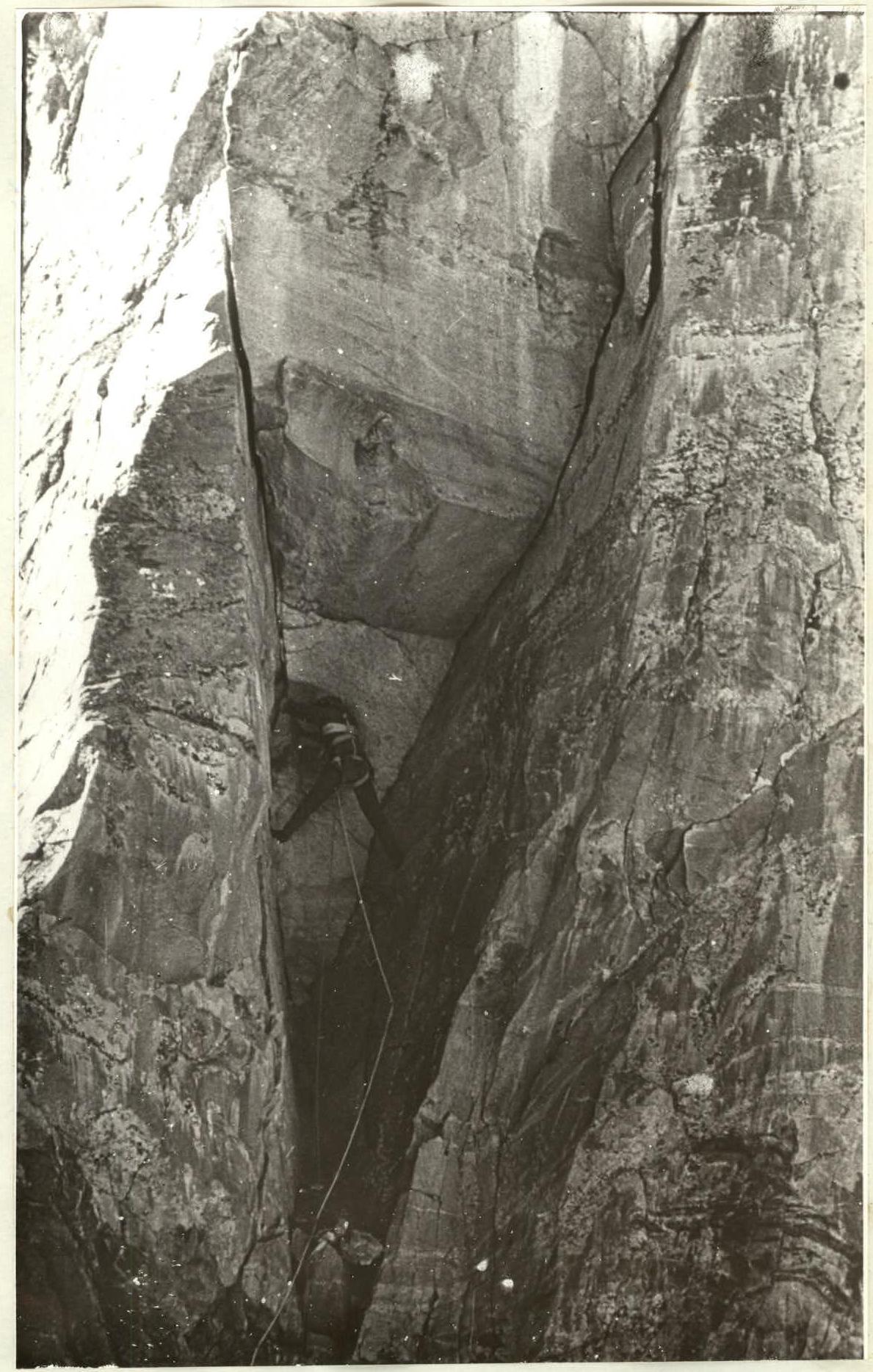
At 14:30, the rope team Samoded–Stavnitscer starts processing the S ridge. Climbing is very challenging, with an overhanging cornice 150–180 cm in overhang, and much overhanging rock. The first cornice (sect. R3–R4) is climbed "head-on," the second is bypassed along the left edge of the ridge, with an exit through an overhanging section. About 100 m are processed in 4 hours. The rock is monolithic; there are small slab sections.
We bivouac alone, creating platforms among the rocks on the saddle. August 2
Ascent at 7:00, departure at 8:30. We pass the pre-placed ropes, exit onto the left edge of the ridge. There's a 40 m wall, then an exit onto ridge slabs. Climbing is on friction. The ridge becomes less steep; sections of smooth rocks with few holds alternate with sections of destroyed rocks.
The leading rope team Bovkun–Boyko suggests setting up a bivouac because there's no suitable place further.
The duo Stavnitscer–Samoded starts processing the route.
60 m are fixed.
We bivouac on narrow shelves, one person each. Samoded is in a hammock.
August 3 We depart at 9:00 with the intention to reach the summit today. On average, today's work is less tense; the rocks are more pronounced, with internal corners and small chimneys. Placement of pitons (stoppers, cams, hexes) goes well.
Today's key section is 30 m of slab-like rocks before exiting onto the right edge of the ridge.
On a small shelf (sect. R16–R17), we find traces of V. Kavunenko's group, which made the first ascent of Peak 5190 via the E wall during the USSR Championship.
By 17:00, we reach rocks abounding in holds and live rocks. We pass 2 small chimneys, an internal corner with a "plug," and by 18:30, we exit onto the ridge. We decide to bivouac here. The platforms are excellent.
August 4 At 9:30, we depart lightly loaded towards the summit. We reach the highest point at 10:30 and retrieve a note left by the first ascenders — V. Kavunenko's group. We descend to our bivouac, then down to the saddle via the ascent route because there's no easier or safer descent.
TABLE OF MAIN CHARACTERISTICS OF THE ASCENT ROUTE TO PEAK 5190 VIA THE SOUTH RIDGE
| Date | Designation | Average steepness in degrees | Length | Character of relief | Difficulty | Condition | Weather conditions | Insurance: rock | ice (into rock) | bolt | placements |
|---|---|---|---|---|---|---|---|---|---|---|---|
| August 1, 1978 | R0–R1 | 35–40° | 360 m | Narrow gully, compressed by sheer walls | 2 | Water, местами наteчный лёд | Clear | 0 | 0 | 0 | 0 |
| R1–R2 | 40–45° | 320 m | — " — | 3–4 | Snow, фирн, местами лёд | — | — | — | — |
Departure — 6:00, stop on the saddle — 12:20, climbing hours — 6 h; bivouac among rocks, one person each. Processing. Simultaneously, through an ice axe.
| Date | Designation | Average steepness in degrees | Length | Character of relief | Difficulty | Condition | Weather conditions | Insurance: rock | ice (into rock) | bolt | placements |
|---|---|---|---|---|---|---|---|---|---|---|---|
| August 2 | R2–R3 | 85° | 30 m | Chimney under a cornice | 6 | Monolith | Clear | 4 | — | 1 | 3 |
| R3–R4 | 100° | 25 m | Wall, cornice | 6 | — " — | 3/1 | 1 | —/1 | 2/1 | ||
| R4–R5 | 95° | 45 m | Wall, overhang | 6 | — " — | 4/1 | 1 | —/1 | 4/1 | ||
| R5–R6 | 90° | 40 m | Wall | 6 | — " — | 5/1 | — | 1 | 2/1 | ||
| R6–R7 | 85° | 35 m | Ridge, slabs | 6 | — " — | 4 | 1 | 1 | 2 | ||
| R7–R8 | 85° | 40 m | Wall with few holds | 6 | — " — | 6 | 2/1 | 1/1 | — | ||
| R8–R9 | 80° | 50 m | Wall, ridge | 5 | — " — | 5 | 1 | — | 2 | ||
| R9–R10 | 75° | 55 m | — " — | 5 | — " — | 4 | 1 | — | 2 | ||
| R10–R11 | 70° | 40 m | — " — | 5 | Destroyed | 3 | 2 | 1 | — | ||
| R11–R12 | 70° | 60 m | — " — | 5 | Heavily destroyed | 2/1 | 3 | — | 1 |
Departure — 8:30; stop — 18:30; climbing hours 9 h 30 min; bivouac on shelves, one person each, hammock. Processing.
| Date | Designation | Average steepness in degrees | Length | Character of relief | Difficulty | Condition | Weather conditions | Insurance: rock | ice (into rock) | bolt | placements |
|---|---|---|---|---|---|---|---|---|---|---|---|
| August 3 | R12–R13 | 80° | 30 m | Chimney, wall | 5 | Monolith | Clear | 2 | 1 | — | 2 |
| R13–R14 | 90° | 30 m | Ridge, wall | 6 | — " — | 3/1 | — | 1/1 | 2 | ||
| R14–R15 | 80° | 40 m | Wall, internal corners | 5 | Large blocks | 4 | — | — | 3 | ||
| R15–R16 | 70° | 80 m | Ridge, internal corner | 5 | Monolith | 4 | 2 | — | 4 | ||
| R16–R17 | 85° | 60 m | Wall, ridge | 5 | — " — | 6/1 | 2 | 1 | 3 | ||
| R17–R18 | 60° | 85 m | Wall; chimneys, internal corners | 4 | Destroyed | 4 | 3 | — | 1 |
Departure — 9:00; stop on the ridge — 19:30; climbing hours — 9 h; bivouac on the ridge, platform on rocks.
| Date | Designation | Average steepness in degrees | Length | Character of relief | Difficulty | Condition | Weather conditions | Insurance: rock | ice (into rock) | bolt | placements |
|---|---|---|---|---|---|---|---|---|---|---|---|
| August 4 | R18–R19 | 40° | 180 m | Ridge, rocks, snow, ice | 3–4 | Destroyed | Clear | simultaneously | outcrops | via | ice axe. |
Departure — 9:30; summit — 10:30; climbing hours — 1 h. The table does not include the time for preliminary route processing, which was done:
- — on August 1 — for 4 hours
- — on August 2 — for 2 hours On section R3–R4. Under the cornice.