South-West Pamir, Shugnan Ridge, Peak 5190, ascent via North-Eastern wall.
Climbing Report.
USSR Climbing Championship.
Technical Climbing Class.

GENERAL VIEW OF PEAK 5190 /SHUGNAN RIDGE/
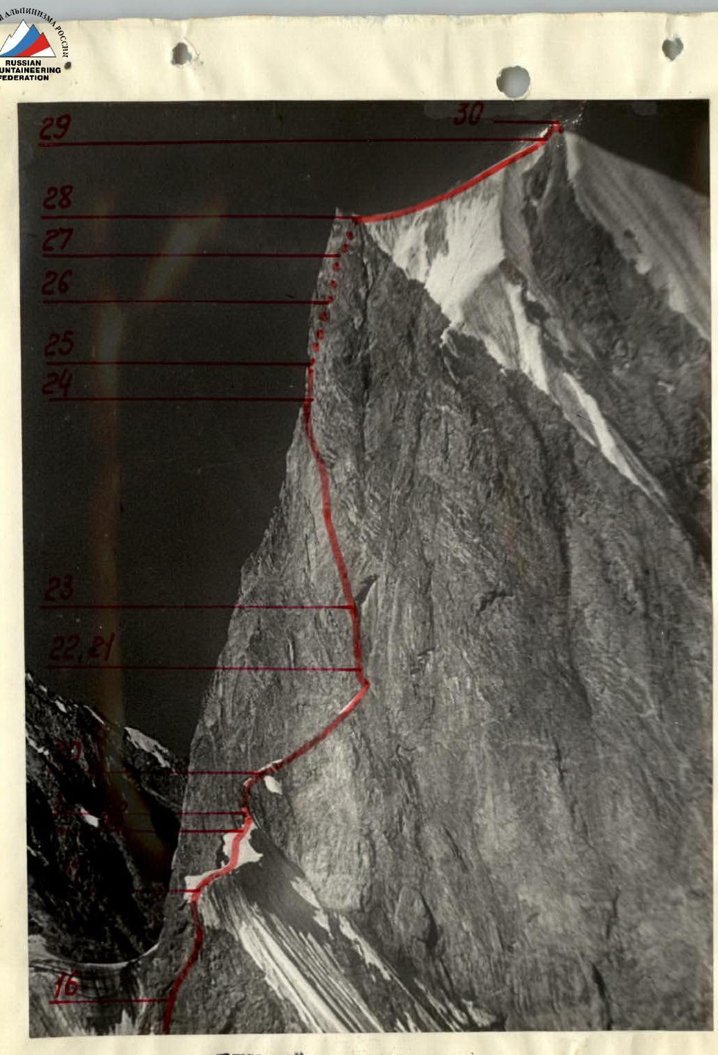
UPPER BASTION
PROFILE OF THE LOWER BASTION /VIEW FROM THE RIDGE TO THE LEFT OF THE UPPER BASTION/
Area of Ascent Scheme
Brief Geographical Information. Preparation for the Ascent
South-West Pamir is a vast mountainous region stretching from the Pyandj River in the south to the Bartang River in the north, defined by the geographical arrangement of ridges, their common climbing characteristics, and the most accessible communication routes leading to the foot of the peaks.
Between the Rushan and Shakhdara ridges of this region lies a vast mountainous knot known as the Shugnan Ridge.
Shugnan is not just a geographical term; it is a historically inhabited region of Badakhshan, where the Gunt and Shakhdara valleys have been home to a hospitable and welcoming people with a rich culture and over a thousand years of highland living traditions.
Domestic mountaineering and geographical literature lacks information on the climbing history of the Shugnan Ridge, despite the exceptional beauty of some of its peaks, convenient access not requiring helicopter or caravan support, and numerous expeditions in recent years to the South-West Pamir.
In 1977, after completing ascents in the Shakhdara Ridge, the team members conducted reconnaissance and photographed an unnamed peak with an elevation of 5190 in the Shugnan Ridge. The peak was deemed to be of significant sporting interest and the materials were submitted for the 1978 USSR Climbing Championship application in the technical climbing class.
The idea of a first ascent on this difficult-to-access peak and the commencement of climbing exploration of the Shugnan Ridge captivated the team of climbing instructors from Moscow's Spartak and Odessa's Avangard, who for the second consecutive year were representing the Alai climbing camp in the national championship.
In the 1978 season, the team conducted their training period in the Kok-Su gorge (Pamir-Alai), where they climbed several routes as part of their preparation, including an alternate object listed in their application.
The relocation from the Kok-Su gorge and the establishment of the base camp near Peak 5190 took 2 days.
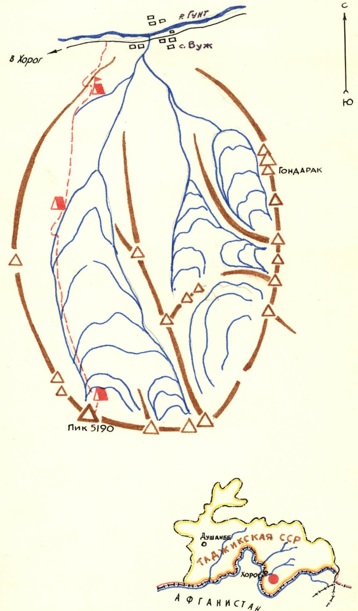
Approach to the Route Description
The road journey along the Pamir Highway from Osh to Khorog ends in the village of Vuk, which is 48 km away from Khorog.
The base camp is situated on the left bank of the Vuk River, which flows from the slopes of the Shugnan Ridge and empties into the Gunt River near the village.
From the village, several footpaths and caravan trails lead to a green meadow suitable for setting up a camp (1 hour walk). There's also a dirt road, but it requires bridging an irrigation canal.
From the base camp, the path to the start of the route goes towards the tongue of a steep and narrow glacier, which feeds the left (orographically) tributary of the Vuk River and lies at the foot of the NE wall of Peak 5190. Then, along the left (orographically) moraine and further along a lateral terrace, which is a combination of slab-like rocks and grassy ledges, to the point where it reaches the snowy slope before the icefall. This is the site of Camp #1. The journey from the base camp takes 4-5 hours. There are safe areas for setting up 3-4 tents, free from falling rocks, and a source of clean water.
The further path under the route goes through the icefall with a complex and constantly changing relief. The entire length of the icefall is exposed to rockfall from the walls of Peak 5190.
Overcoming the icefall, subglacial crevices, and steep rocks while bypassing the most mobile ice sections, taking into account rockfall danger, is a complex tactical task requiring the use of modern ice and rock climbing techniques.
Camp #2 (assault camp) is located on a small, enclosed section in the middle of the glacier, before the second step of the icefall, opposite the snowy ridge between Peak 5190 and an unnamed peak to the left.
The relief of the icefall is so changeable that each passage through the most complex sections requires their repeated processing.
From Camp #1, it takes 8-9 hours to reach Camp #2. The time can significantly increase due to greater fragmentation, rockfall danger, etc.
Ascent Description
(a brief explanation of the table of main characteristics)
On July 19, 1978, at 4:00 AM, the team left the base camp. Four hours later, they reached Camp #1, where they rested, clarified the radio communication scheme with the observation group, identified points for visual observation, and prepared for work on the icefall.
At 9:00 AM, the team began their ascent towards the assault camp. Overcoming the icefall requires rapid movement and constant observation of Peak 5190's walls, from which rockfalls periodically occur.
There are many crevices, ice walls, lattice-like bridges, chaotic heaps of boulders, and seracs. Eight hours of continuous movement. 18 ice screws and 6 rock anchors were hammered.
In the evening, at the assault camp, the team prepared for work on the route, attended to various household chores, and rested.
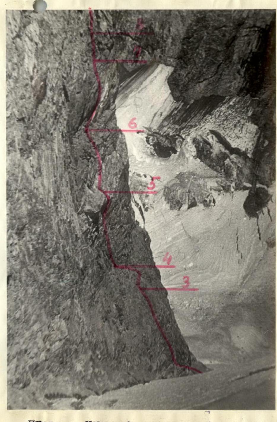
On July 20, 1978, at 8:00 AM, three team members in one rope team started ascending the lower bastion's wall with the task of processing 4-6 ropes and reaching a possible bivouac site near the "Feathers" (sections R1-R9).
Having overcome the bergschrund and the ice slope, the rope team reached the rocks and, after three ropes of demanding climbing up the wall transitioning into an internal corner, approached a narrow "yellow" ledge on a very broken section. From the ledge towards the "Feathers" - a noticeable outcrop - difficult climbing up an internal corner with an overhang. Then, a wall (a combination of corners and slabs). Before entering a narrow, upward-widening crevice - a 7-meter wall with an overhang. After the crevice, using a wall of strong blocks, they reached a "balcony" - a narrow ledge where a sitting bivouac is possible.
There is no water on sections R2-R9.
While the first rope team worked above the "yellow" ledge (sections R3-R4), four team members transported 40 kg of cargo to the "yellow" ledge.
By 7:00 PM, everyone descended to the assault camp.
On July 21, 1978, at 7:00 AM, they dismantled the assault camp and began their ascent along the processed path.
The nature of the relief, rock, structure, and the presence of broken sections, as well as the absence of a convenient and safe spot on the wall, made it impossible to pull up rucksacks from the "yellow" ledge.
The cargo to the "balcony" was decided to be delivered by shuttle.
At 2:00 PM, the team started setting up a bivouac on the "balcony." Meanwhile, one rope team processed the wall up to the exit onto the bastion's ridge (sections R9-R15).
By 8:00 PM, everyone was on a sitting bivouac.
On July 22, 1978, at 8:00 AM, they began their ascent along the processed path. After a 20-meter monolithic wall, they reached a narrow, inclined, and partly overhanging ledge. Then, a wall with some broken sections led to inclined monolithic slabs, behind which the bastion's ridge was discernible (sections R9-R13).
Up to the ridge, there were two ropes of climbing: first, along unstable rocks, and then along monolithic slabs (sections R13-R14, R14-R15).
After passing the processed section, the further path along the rocky, partly very broken ridge, with small walls, internal corners, and heaps of blocks, seemed relatively easy. Having overcome an ice wall, they reached a gentle section of the ice ridge, where they stopped for the night and set up a lying bivouac (section R17-R18).
On July 23, 1978, according to the tactical plan, this was a day for observing the upper bastion to clarify the further path and its processing.
The most logical and safe route was considered to be along the left part of the wall. Two rope teams processed the path up to the cornice at the lower part of the upper bastion's wall and returned for the night (sections R18-R23).
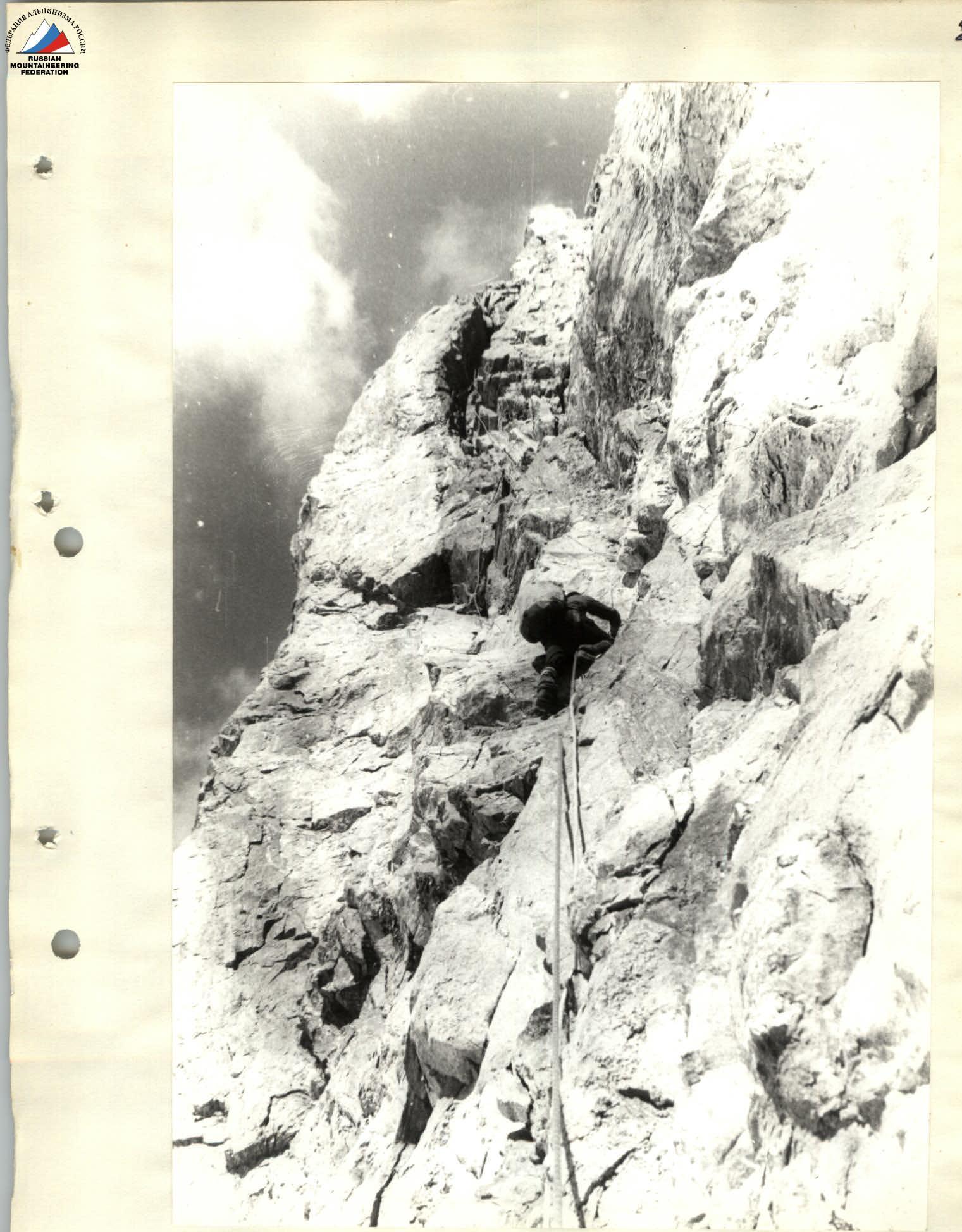
On July 24, 1978, they departed at 6:00 AM along the scouted and processed path. An ice wall led to an internal corner composed of separate blocks. Further along the rocky ridge, transitioning into a scree-covered, snow-covered slope and a ledge, they reached under a monolithic 40-meter wall with an overhang. The wall was climbed using artificial aids (ITOS).
- Rucksack extraction.
The further path (section R23-R24) went along strong crevices of the wall, almost vertically upwards, using small crevices. One of the most difficult sections of the wall. The general direction was towards a notch in the summit ridge.
Rucksack extraction.
At 7:00 PM, near the notch, they set up a sitting bivouac. There was clean ice in the crevice.
On August 25, 1978, at 6:00 AM, they began moving without rucksacks along a нависающему caмин (section R24-R25), in the upper part of which there was a plug of "live" stones. Further - difficult but pleasant climbing along sheer monolithic rocks under an overhanging stone.
Having passed the caмин and a 25-meter wall with a slight overhang in its upper part, they cautiously overcame strongly destroyed rocks upwards to the right. Another rope length on rocks of medium difficulty - and they were on the ice ridge leading them to the summit. They ascended to the summit on rocks of medium difficulty. At 2:00 PM, they made radio contact with the base camp.
After communication, they descended and spent the night at the notch. A short rest. Further descent and overnight stay on the ice ridge between the bastions.
On August 26, 1978, they descended along the ascent route to the glacier and further to the base camp.
PROFILE SCHEME OF THE ROUTE (in conventional images)
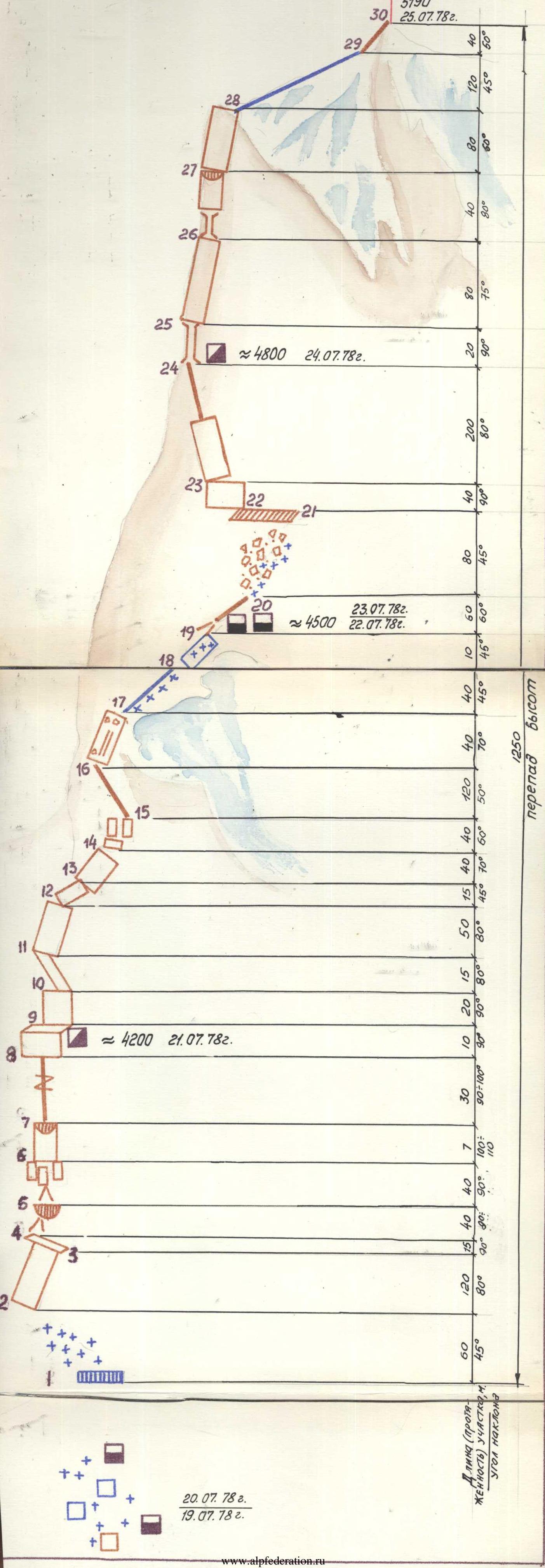
Table
of main characteristics of the ascent route to Peak 5190 (Shugnan Ridge) via the NE wall
| Date | Section | Steepness | Length | Relief Character | Difficulty Category | Relief State | Weather Conditions | Rock Anchors | Ice Anchors | Piton Anchors | Notes |
|---|---|---|---|---|---|---|---|---|---|---|---|
| 19.07 | R0–R1 | 0–60° | 2000 | Glacier, icefall, rock and ice walls | 2–5 | Ice collapses, rockfalls from slopes, crevices | clear | 6 | 18 | - | Departure from Camp #1 at 9:00 AM. Arrival at Camp #2 at 5:00 PM. Total climbing hours - 8 |
| 20.07 | R1–R2 | 45° | 60 | Slope | 4 | Ice, bergschrund | clear | - | 3 | - | Processing of the lower bastion and partial cargo transportation to the route. Departure from Camp #2 at 8:00 AM. |
| R2–R3 | 80° | 120 | Wall | 5–6 | Monolith, separate broken sections | 28 | 2 | - | |||
| R3–R4 | - | 15 | Ledge | 3 | Broken rocks | 2 | - | - | |||
| R4–R5 | 80° | 40 | Internal corner, overhang | 5 | Monolith | 11 | - | 1 | |||
| R5–R6 | 90° | 40 | Wall, combination of corners and slabs | 6 | Monolith, partly broken | 7 | - | - | |||
| R6–R7 | 100-110° | 7 | Wall with overhang | 6 | Monolith | 4 | 11 | 1 | |||
| R7–R8 | 90-100° | 30 | Crevice | 6 | Broken | 6 | - | - | |||
| R8–R9 | 90° | 10 | Wall leading to a ledge | 5 | Monolithic blocks | 3 | - | - | |||
| 21.07 | R9–R10 | 90° | 20 | Wall | 6 | Monolith | clear | 3 | 1 | 1 | Departure from Camp #2 at 7:00 AM. Arrival at bivouac at 8:00 PM. Total climbing hours - 10. Processing of the upper part |
| R10–R11 | 80° | 15 | Narrow inclined ledge | 5 | Broken | 5 | - | - | |||
| R11–R12 | 80° | 50 | Wall | 6 | Broken | 8 | - | - | |||
| R12–R13 | 45° | 15 | Inclined slab | 4 | Monolith | 4 | - | - | |||
| R13–R14 | 70° | 40 | Wall | 5 | Unstable rocks | 11 | - | - | |||
| R14–R15 | 60° | 40 | Slabs | 5 | Monolith | 5 | - | - | |||
| 22.07 | R15–R16 | 50° | 120 | Rocky ridge | 4 | Broken | clear | 12 | - | - | Departure at 8:00 AM. Arrival at bivouac at 7:00 PM. Total climbing hours - 10. Lying bivouac. |
| R16–R17 | 70° | 40 | Wall, internal corner | 4 | Broken | 6 | - | - | |||
| R17–R18 | 45° | 40 | Ice ridge | 4 | Ice | - | 2 | - | |||
| 23.07 | R18–R19 | 45° | 10 | Ice wall | 4 | Ice | clear | - | 1 | - | Reconnaissance and processing of the upper bastion. Departure for processing at 10:00 AM. Return to bivouac at 4:00 PM. |
| R19–R20 | 60° | 30 | Internal corner, rocky ridge | 3 | Broken | alternately | - | - | |||
| R20–R21 | 45° | 80 | Scree-covered snowy slope | 3 | Snowy, rockfalls | alternately | - | - | |||
| R21–R22 | - | 80 | Ledge under the upper bastion | 3 | Snowy, rockfalls | alternately | - | - | |||
| R22–R23 | 90° | 40 | Wall with overhang | 6 | Monolith | 4 | 1 | - | |||
| 24.07 | R23–R24 | 80° | 200 | Wall, crevice, notch | 6 | Monolith | clear | 37 | - | 2 | Departure at 6:00 AM. Arrival at bivouac at 7:00 PM; sitting bivouac. Total climbing hours - 10 |
| 25.07 | R24–R25 | 90° | 20 | Chimney | 5 | Monolith, "live" stones | clear | 6 | 1 | - | Departure at 6:00 AM. Summit arrival at 2:00 PM. Total climbing hours - 8 |
| R25–R26 | 75° | 80 | Wall | 5 | Monolith | 14 | - | - | |||
| R26–R27 | 80° | 40 | Chimney, wall with overhang | 5 | Monolith | 10 | - | 1 | |||
| R27–R28 | 60° | 80 | Wall leading to the summit ridge | 3 | Broken | 6 | - | - | |||
| R28–R29 | 45° | 120 | Ice ridge | 3-4 | Ice | - | 8 | - | |||
| R29–R30 | 50° | 40 | Rocky ridge | 3 | Monolith | alternately | - | - |
Note. Data for section R0–R1 were considered only when determining the total number of anchors used and total climbing hours.
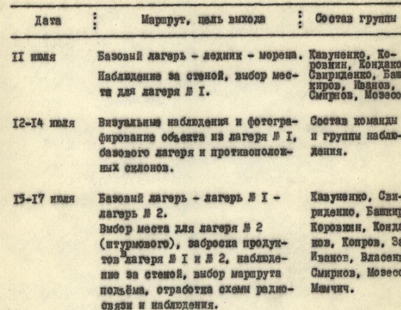
Information on Reconnaissance and Supply Deliveries
Justification of Route Choice and Ascent Tactics Development
The team faced the task of a first ascent on Peak 5190 in a previously unexplored region, which significantly complicated issues related to approaches, the choice of a specific ascent route, and the development of tactics.
As a result of studying the macro-relief of the wall, the character and degree of rockfall danger observed from the glacier, and considering the choice of the most difficult yet safe path, and giving preference to the logic of the route and the team's desire to climb using free climbing techniques with minimal use of ITOS, the final route variant was chosen. The most optimal choice, balancing considerations of logic, safety, and difficulty, was the ascent via the center of the lower bastion, exiting onto an ice shoulder, and then along the sheer of the upper bastion towards the ice-covered summit.
While the lower part of the route was practically unambiguous due to the increased danger of other possible variants and was well-studied during observations from the glacier, the upper bastion required additional study during the ascent since observations from the glacier only determined the general possible direction of a safe route but did not provide a clear answer about:
- the character of the rocks;
- the trajectory of falling stones.
When developing the ascent tactics, the following main issues were taken into account:
- The presence on the route of a combination of monolithic and broken (partly significantly) sections with overall great steepness and technical complexity.
- The absence on the bastions of places convenient for bivouacs.
- The presence of a large number of sections with overhangs.
- The numerical composition of the group being 8 people.
- Possible unforeseen circumstances related to the route being a first ascent and the need for additional study of the upper bastion.
- The absence of studied safe descent paths.
- The absence of visible water sources on the lower and upper bastions.
Based on these considerations, the tactical plan provided for:
1.  The use of daily preliminary reconnaissance and processing to ensure fast passage and, related to this, the establishment of bivouacs at an optimal distance to create a time reserve for processing.
2.  Passage of the route within optimal terms with a rational distribution of participants' strength and a reserve of strength for the final days and descent.
3.  Provision of a universal set of practically all types of modern rock and ice climbing equipment and a significant reserve of rope.
4.  The possibility of quickly changing the group's movement scheme depending on the relief character.
5.  The use of wall ration and bivouac equipment to minimize rucksack weight.
6.  Development of a stable radio communication scheme with the observation group and base camp at any section of the route.
7.  Utilization of the experience of joint wall ascents and established work practices among participants, who are experienced and well-trained for routes of any difficulty.
These tactical plan provisions formed the basis of the developed route documentation and were fully adhered to during the ascent.
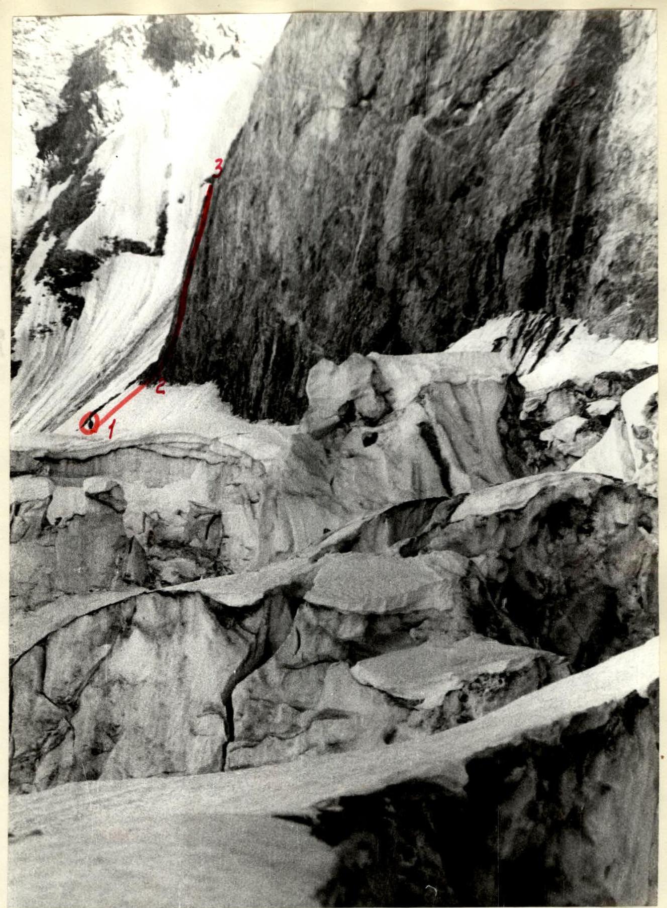
AREA OF ASSAULT CAMP (SECTIONS R0–R1, R1–R2, R2–R3)
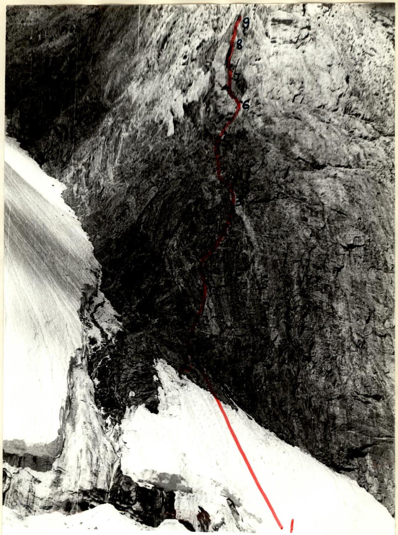
LOWER BASTION (SECTIONS R2–R9)
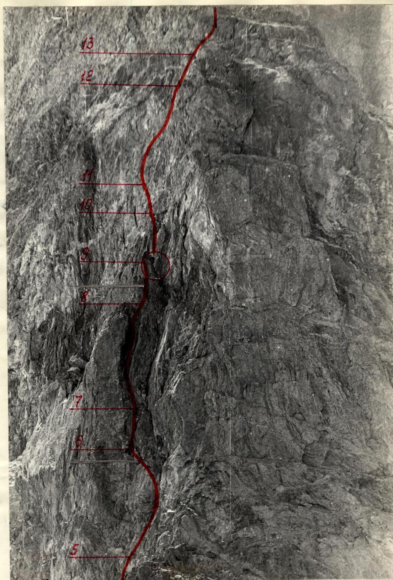
LOWER BASTION (SECTIONS R4–R14)
EXIT TO "PERYA" (FEATHERS)
UPPER BASTION WALL (SECTION R23–R24)


