
Ascent Passport
- Ascent class — technical
- Ascent area — South-West Pamir, North Shugnan Ridge
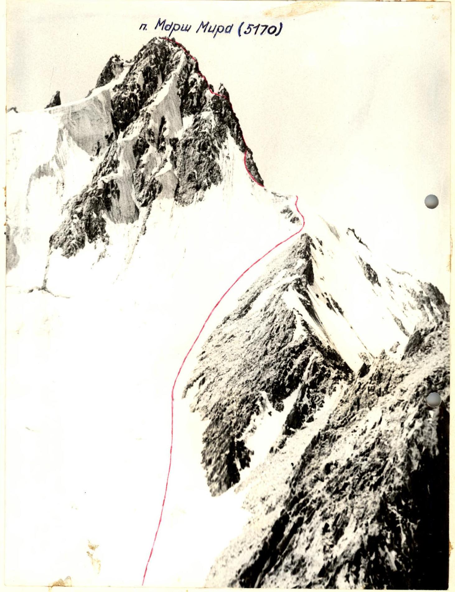
- Peak — Marsh Mira, 5170 m, via the northern ridge, combined
- Proposed difficulty category — 4A
- Route characteristics: height difference — 475 m, average steepness of the ridge — 55°, length of sections of 3rd cat. diff. — 165 m, 4th cat. diff. — 210 m, 5th cat. diff. — 65 m.
- Pitons driven:
| for belay | for standing pitons | |
|---|---|---|
| rock | 22 | — |
| ice | 13 | — |
| bolt | — | — |
| chocks | 5 | 1 |
- Number of climbing hours — 8
- Number of nights on the route and their characteristics — none
- Leader: Zarutsky A.G. — 1st sports category
Team members:
- Fedyaev A.L. — 1st sports category
- Bochkov V.V. — 1st sports category
- Poludov S.A. — 1st sports category
- Team coach: Ryabukhin A.G., Honored Coach of the RSFSR
Brief Description of the Approach
To the Route
By car from Osh, along the Pamir Highway, pass the village of Vir, and at the 58th km (counting from Khorog), on the left side along the way in a willow grove is the base camp.
The "4300" assault camp is located on the right (orographically) side of the Vodj Severny glacier, under the saddle between peak 4971 and peak Vodj. The approach from the base camp to the "4300" camp takes 4 hours.
From here, the approach to the route takes 2 hours. From the "4300" camp, move along the right (orographically) side of the glacier. In the central part, cross the glacier and on the left (orographically) side approach the snow-ice saddle between peak Marsh Mira and peak 4900. The route begins here.
| Point/Feature | Value/Description |
|---|---|
| 3150 | 3800 |
| 3150 | 2905 r. Gunt |
| 3904 | 4700 |
| 5204 | 4300 |
| 5204 | 4300 |
| Gondarak | 4300 |
| p. 4971 | |
| Marsh Mira | 5170 |
| 5190 | 5434 Vodj |
| 5190 | 5434 Vodj |
| 5150 | Mairanis |
Photo #1. General view of the peak.
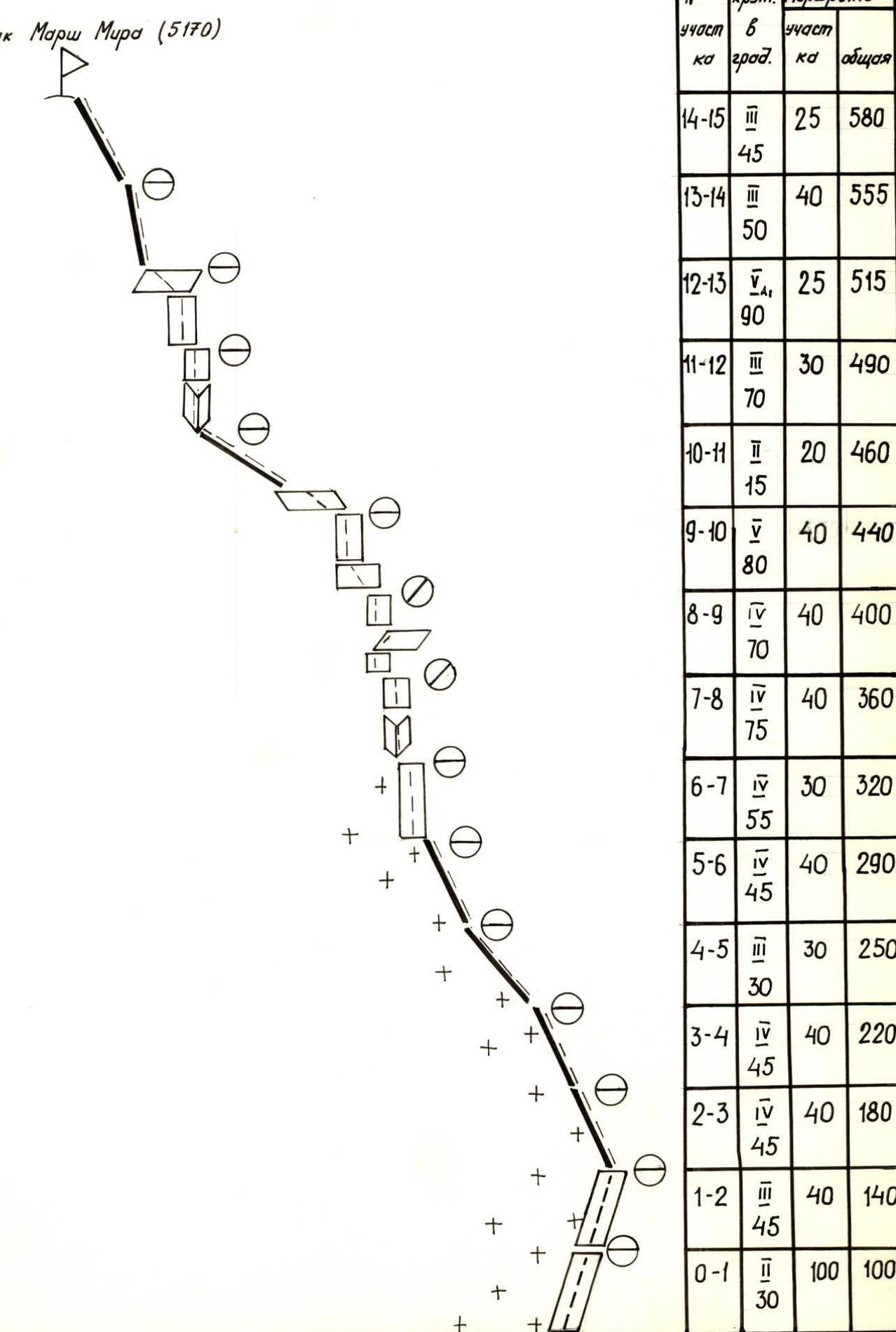
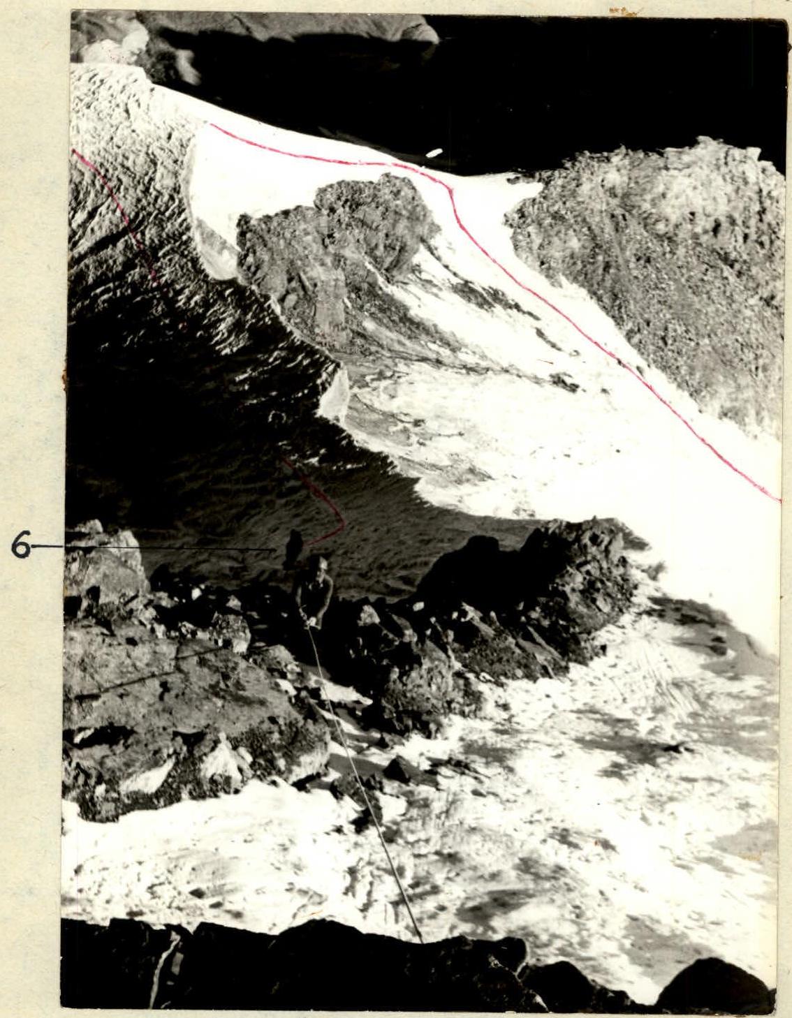
Photo #5. Section R6–R7.
Peak Marsh Mira (5170)
| Section # | Cat. diff. of section | Steepness (°) | Length of section (m) | Total length (m) |
|---|---|---|---|---|
| R14–R15 | 3 | 45 | 25 | 580 |
| R13–R14 | 3 | 50 | 40 | 555 |
| R12–R13 | 4 | 90 | 25 | 515 |
| R11–R12 | 3 | 70 | 30 | 490 |
| R10–R11 | 2 | 15 | 20 | 460 |
| R9–R10 | 4 | 80 | 40 | 440 |
| R8–R9 | 4 | 70 | 40 | 400 |
| R7–R8 | 4 | 75 | 40 | 360 |
| R6–R7 | 4 | 55 | 30 | 320 |
| R5–R6 | 4 | 45 | 40 | 290 |
| R4–R5 | 3 | 30 | 30 | 250 |
| R3–R4 | 4 | 45 | 40 | 220 |
| R2–R3 | 4 | 45 | 40 | 180 |
| R1–R2 | 3 | 45 | 40 | 140 |
| R0–R1 | 2 | 30 | 100 | 100 |
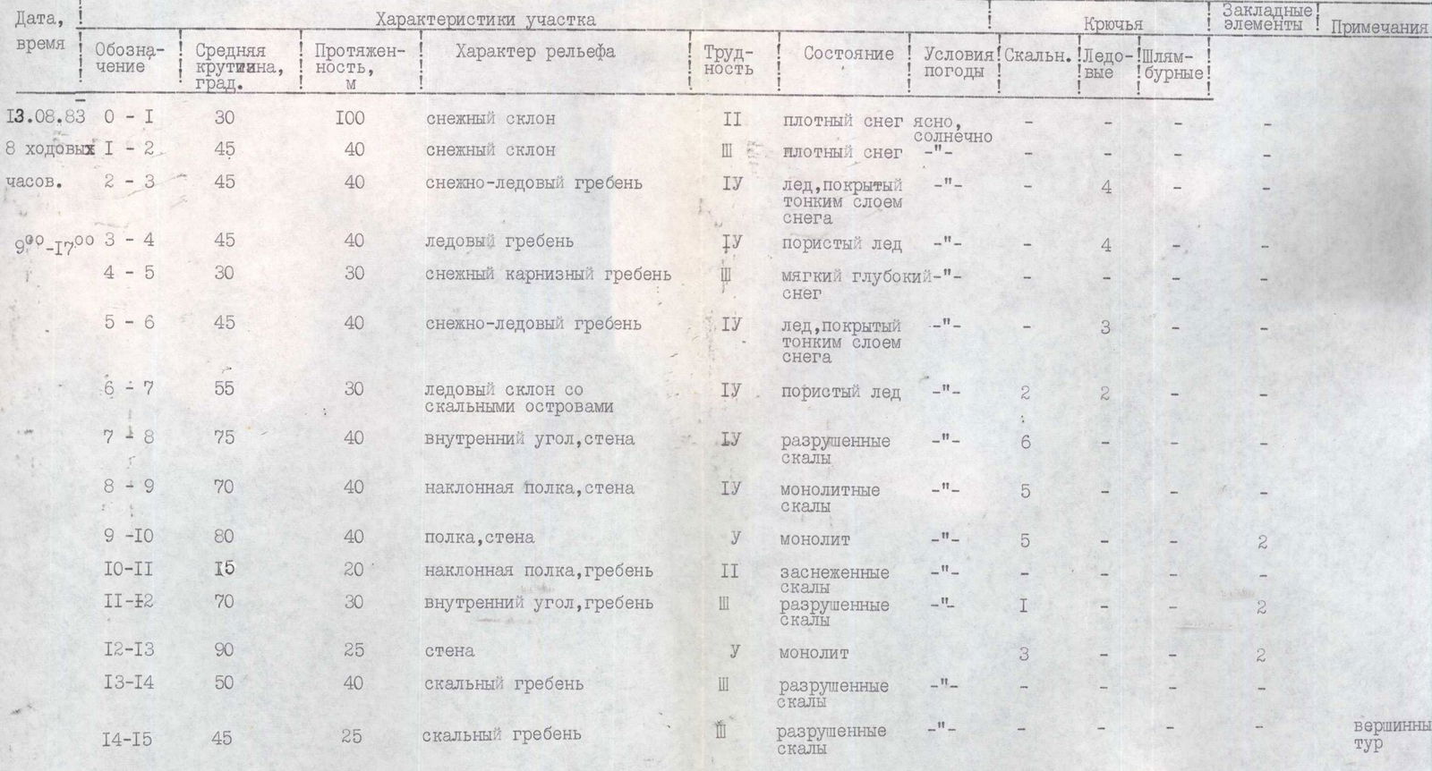
Table of Main Ascent Characteristics
| Date, time | Designation | Average steepness, ° | Length, m | Terrain characteristics | Difficulty | Condition | Weather conditions | Rock pitons | Ice pitons | Bolt pitons | Chocks | Notes |
|---|---|---|---|---|---|---|---|---|---|---|---|---|
| August 13, 1983 | R0–R1 | 30 | 100 | snow slope | 2 | dense snow | clear, sunny | — | — | — | — | |
| 8 climbing hours | R1–R2 | 45 | 40 | snow slope | 3 | dense snow | — | — | — | — | — | |
| R2–R3 | 45 | 40 | snow-ice ridge | 4 | ice covered with a thin layer of snow | — | 4 | — | — | — | ||
| from 9:00 to 17:00 | R3–R4 | 45 | 40 | ice ridge | 4 | porous ice | — | 4 | — | — | — | |
| R4–R5 | 30 | 30 | snow cornice ridge | 3 | soft deep snow | — | — | — | — | — | ||
| R5–R6 | 45 | 40 | snow-ice ridge | 4 | ice covered with a thin layer of snow | — | 3 | — | — | — | ||
| R6–R7 | 55 | 30 | ice slope with rock outcrops | 4 | porous ice | — | 2 | 2 | — | — | ||
| R7–R8 | 75 | 40 | inner corner, wall | 4 | destroyed rocks | — | 6 | — | — | — | ||
| R8–R9 | 70 | 40 | inclined ledge, wall | 4 | monolithic rocks | — | 5 | — | — | — | ||
| R9–R10 | 80 | 40 | ledge, wall | 5 | monolith | — | 5 | — | — | 2 | ||
| R10–R11 | 15 | 20 | inclined ledge, ridge | 2 | snow-covered rocks | — | 1 | — | — | — | ||
| R11–R12 | 70 | 30 | inner corner, ridge | 3 | destroyed rocks | — | 1 | — | — | 2 | ||
| R12–R13 | 90 | 25 | wall | 5 | monolith | — | 3 | — | — | 2 | ||
| R13–R14 | 50 | 40 | rock ridge | 3 | destroyed rocks | — | — | — | — | — | ||
| R14–R15 | 45 | 25 | rock ridge | 3 | destroyed rocks | — | — | — | — | — | summit cairn |
Descent from the peak via the ascent route. 8 rappels were organized. The descent took 3 hours 30 minutes.