
Ascent Passport
-
Ascent class — technical
-
Ascent area — North Shugnanskiy ridge
-
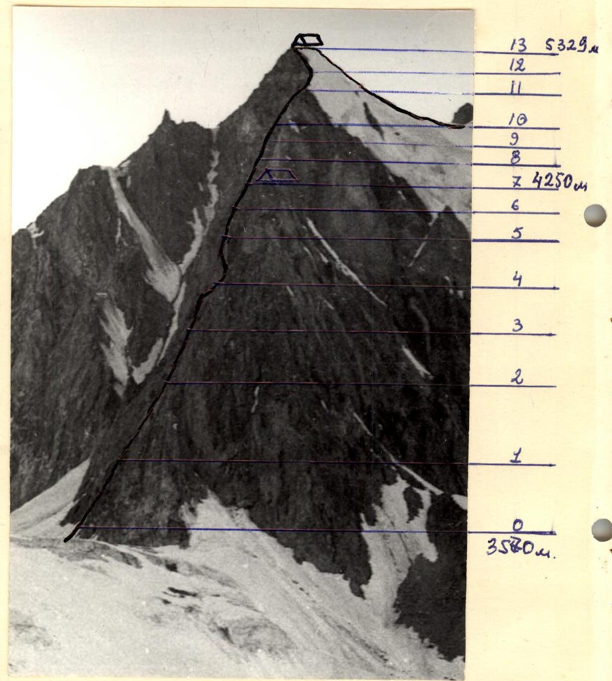
Peak, its height, ascent route — peak Dzheraim 5329 m via the left counterfort of the eastern wall
-
Proposed difficulty category — 5B
-
Route characteristics:
height difference — 1760 m average steepness — 56° length of sections: I — none, II — 800 m, III — none, IV — 810 m, V — 440 m, VI — 90 m.
-
Pitons hammered:
for belaying rock 133 pcs. ice — bolted — for creating I.T.O.: X
-
Number of climbing hours — 23.5 h
-
Surname, name, patronymic of the leader and participants, their sports qualification: KULYAMIN Vladimir Romanovich — CMS, leader BERESNEV Valeriy Prokhorovich — CMS, participant MOLDOVANOV Alexander Anatolyevich — CMS, participant GOLUBENKO Mikhail Nikolayevich — CMS, participant
-
Team coach — KENSITSKIY Leopold Vsevolodovich — Master of Sports of the USSR, senior instructor.
-
Number of bivouacs and their characteristics — 2 bivouacs, bivouac conditions normal.
-
Departure to the route August 2, 1978. Return August 5, 1978.
 www.alpfederation.ru
www.alpfederation.ru
Route Profile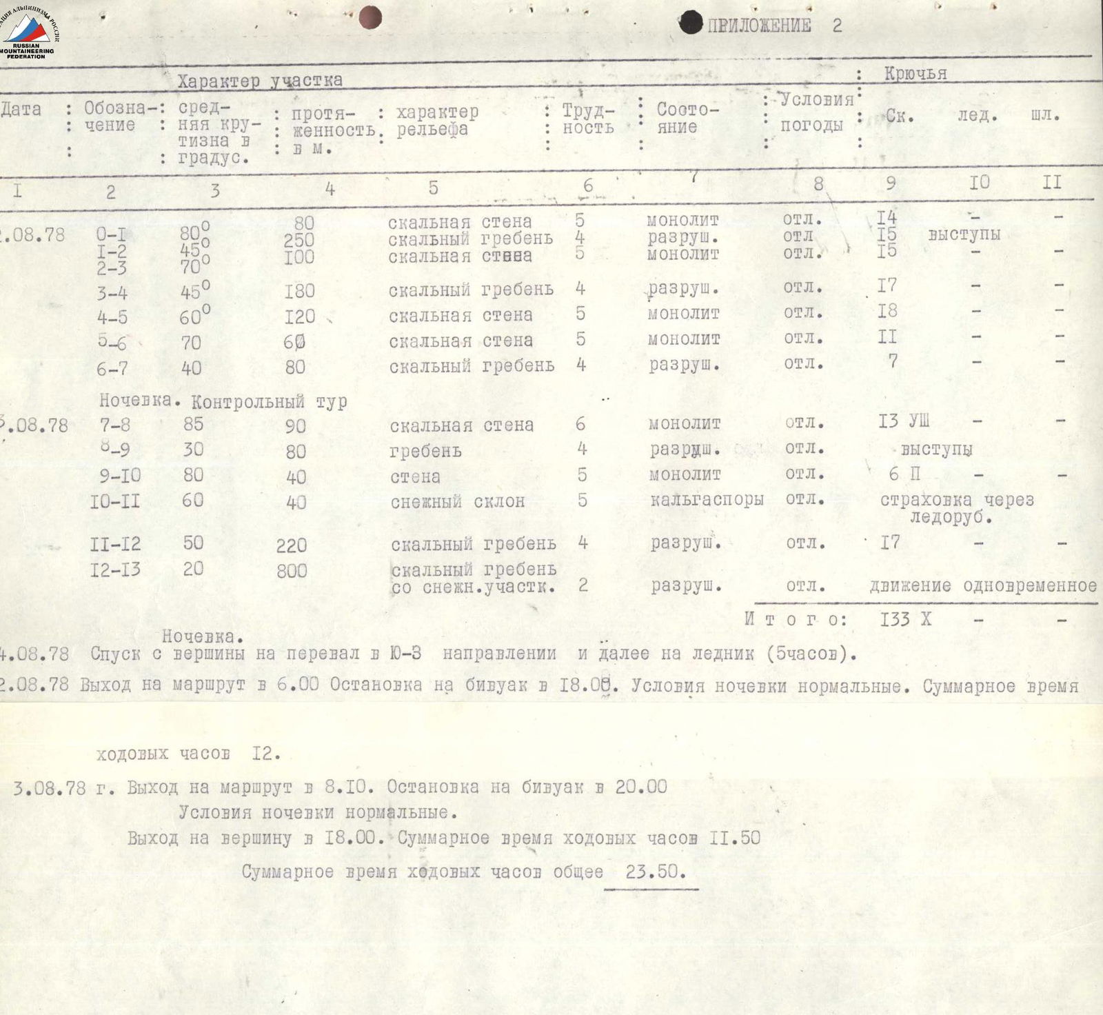
Section Characteristics
| Date | Designation | Average steepness in degrees | Length, m | Relief characteristics | Difficulty | Condition | Weather conditions | Pitons: Rock | Ice | Bolted |
|---|---|---|---|---|---|---|---|---|---|---|
| 2.08.1978 | R0–R1 | 80 | 80 | rock wall | 5 | monolith | excellent | 14 | — | — |
| R1–R2 | 45 | 250 | rock ridge | 4 | destroyed | excellent | 15 | ledges | — | |
| R2–R3 | 70 | 100 | rock wall | 5 | monolith | excellent | 15 | — | — | |
| R3–R4 | 45 | 180 | rock ridge | 4 | destroyed | excellent | 17 | — | — | |
| R4–R5 | 60° | 120 | rock wall | 5 | monolith | excellent | 18 | — | — | |
| R5–R6 | 70 | 60 | rock wall | 5 | monolith | excellent | 11 | — | — | |
| R6–R7 | 40 | 80 | rock ridge | 4 | destroyed | excellent | 7 | — | — | |
| Bivouac. Control tour | ||||||||||
| 3.08.1978 | R7–R8 | 85 | 90 | rock wall | 6 | monolith | excellent | 13 | — | — |
| R8–R9 | 30 | 80 | ridge | 4 | destroyed | excellent | — | ledges | — | |
| R9–R10 | 80 | 40 | wall | 5 | monolith | excellent | 6 | — | — | |
| R10–R11 | 60 | 40 | snow slope | 5 | hanging | excellent | — | belay | via ice axe | |
| R11–R12 | 50 | 220 | rock ridge | 4 | destroyed | excellent | 17 | — | — | |
| R12–R13 | 20 | 800 | rock ridge with snow sections | 2 | destroyed | excellent | — | simultaneous movement | ||
| Total: | 133 | X | — |
Bivouac. August 4, 1978. Descent from the summit to the pass in the southern direction and further to the glacier (5 h). August 2, 1978. Departure to the route at 6:00. Stop for bivouac at 18:00. Bivouac conditions normal. Total climbing time 12 h. August 3, 1978. Departure to the route at 8:10. Stop for bivouac at 20:00. Bivouac conditions normal. Reached the summit at 18:00. Total climbing time 11.5 h. Total climbing time overall 23.5 h.
Brief description of the approach to the route
The peak "5329" is located in the North Shugnanskiy ridge of the South-West Pamir. The approach to the peak is made on the 59th km from Khorog on the Osh-Khorog highway. From the base camp up the trail along the left bank of the Nomatsdary river to the cirque of the glacier flowing from peak "4800" and peak "5204", to the Khaf pass. From the pass, a panorama of peak "5329" is clearly visible. The left counterfort of the peak is the route. From the Khaf pass, 2 rock ridges are clearly visible, which must be crossed when approaching the route. The approach from the Osh-Khorog highway takes 12–14 h.
Brief explanation for the table
Peak "5329" is located in the North Shugnanskiy ridge. The route is rock. First, along the left rock counterfort to its summit, then along the combined snow-rock ridge to the summit. The entire route can be divided into the following sections:
- R0–R1 — rock wall
- R1–R2 — rock ridge
- R2–R3 — wall
- R3–R4 — ridge
- R4–R5 — wall
- R5–R6 — wall
- R6–R7 — ridge
- R7–R8 — wall
- R8–R9 — ridge
- R9–R10 — wall
- R10–R11 — snow slope
- R11–R12 — rock ridge
- R12–R13 — combined snow-rock ridge, summit
The following is a description of the route with a detailed indication of the characteristic sections of the ascent:
- 0–I — from the bivouac on the moraine along the glacier, approach to the beginning of the left counterfort. Along the wall with a steepness of 80° for 80 m to the ridge. Complex climbing.
- I–2 — further straight up along the destroyed ridge in the direction of the reddish wall with a characteristic chip to the left.
- 2–3 — the reddish wall with a steepness of 70° is overcome straight up and further along the ridge in the direction of the rock finger.
- 3–4 — from the rock finger in the direction of the gray ridge, turning into a wall.
- 4–5 — 20 m up the wall to the base of the "gendarme". The "gendarme" is passed straight up. From the top of the "gendarme" a 80 m descent to the saddle.
- 5–6 — from the saddle, ascent up the wall with a steepness of 70° to the ridge.
- 6–7 — along the ridge to a small "gendarme", which is bypassed on the right side. Bivouac. Control tour.
- 7–8 — from the bivouac straight up the wall with a steepness of up to 85° for 90 m to the shoulder of the ridge. Very complex climbing. The wall is passed using ITO. Key point of the route.
- 8–9 — from the shoulder along the destroyed ridge under the wall.
- 9–10 — the wall with a steepness of up to 80° is passed by very complex climbing using ITO along the system of cracks in the right part.
- 10–11 — exit to the snow ridge. To the left is a light wall, which is bypassed on the right along a steep snow slope. The snow is very unstable, with hanging icicles up to 1.5 m high.
- 11–12 — from the snow, transition to a very destroyed rock ridge leading to the summit of the counterfort. Many loose stones. Unstable rock. It is necessary to be extremely careful, as it is very difficult to organize reliable belaying 220 m, 50°.
- 12–13 — from the summit of the counterfort along the combined snow-rock ridge to the summit and then return to the summit of the counterfort. Bivouac. Conditions normal.
Descent in the southern direction to the pass and further to the glacier takes 5 h. Return to the base camp along the approach path.
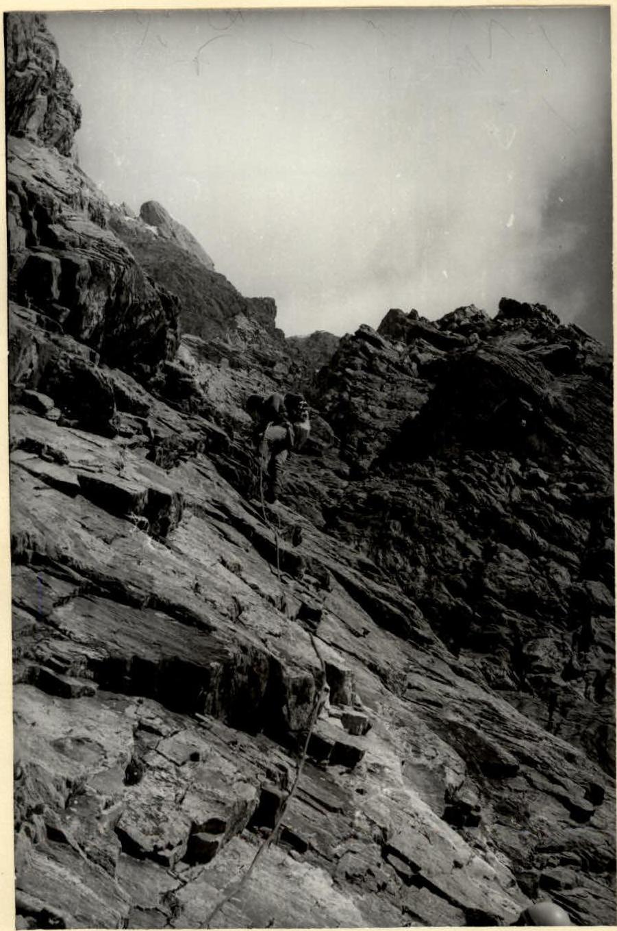
Section 3–4
Comments
Sign in to leave a comment