Climbing Passport
-
Climbing category — technical.
-
South-West Pamir, Shugnan Ridge.
-
Peak 5204 m, first ascent via the Eastern wall.
-
Proposed difficulty category — 5B.
-
Route characteristics:
height difference — 1500 m; average steepness — 58°.
-
Length of sections with 5th and 6th difficulty categories — 780 m.
-
Number of pitons driven for belaying: for creating artificial holds:
| rock | : | 114 | 11 |
| ice | : | 7 | – |
| bolt | : | 2 | 1 |
| chocks | : | 69 | 9 |
-
Number of walking hours — 31.
-
Overnight stays — 2, on snow, in a tent.
-
Group composition:
Orobey I. A., Candidate for Master of Sports, instructor, leader; Gorbenko M. M., Candidate for Master of Sports, instructor, participant; Serpak A. A., Candidate for Master of Sports, instructor, participant; Staritsky P. I., Candidate for Master of Sports, instructor, participant.
-
Team coach — Master of Sports, senior instructor, V. S. Sviridenko.
-
Departure to the route July 21, 1978.
return July 24, 1978
 Map of the area
Brief description of the approach to the route
Peak 5204 m is located in the northern spur of the Shugnan Ridge and is clearly visible for many kilometers along the Pamir Highway.
The starting point from which the trail begins, leading to the peak, is the 59th km of the Pamir Highway from the city of Khorog, near the village of Vir.
The trail leads in a steep serpentine to the green meadows of the Namadara River valley. The trail is beaten, convenient for pack transport, and goes along the left bank of the Namadara River (here and further orographically) to a large left tributary originating from the Vodzh-1 glacier — 1.5 hours.
Further along the left bank of the tributary, through onion fields, upstream. The trail disappears behind the final large moraine. On the green glades is the initial bivouac — 1.5 hours.
From this place, the first half of the route is clearly visible. To the beginning of the route — a giant snow-ice cone, half an hour's walk.
Tactical plan for the ascent
The ascent to peak 5204 m was planned during the general reconnaissance of the area. Preliminary visual examination showed that a logical, unambiguous wall route with a rather large height difference, approximately 5B category of difficulty, is visible to the peak via the Eastern wall.
More thorough targeted reconnaissance confirmed the group's observations:
- studying the route;
- observing possible rockfall areas;
- photographing the peak from all necessary points;
- determining possible descent paths from the route (if necessary);
- determining (approximately) possible overnight stay locations;
- obtaining consultations on the most convenient paths to approach the route from the first ascenders.
Consultations obtained from the first ascenders made it possible to learn about the structure of the rocks, which allowed selecting metal equipment (piton), footwear, and bivouac gear. Additionally, consultation on the descent path was obtained.
Careful observation of the peak made it possible to refine the ascent path and roughly plan overnight stay locations.
The tactical plan determined the movement schedule, which provided for the ascent to the peak to be carried out with two overnight stays and descent to the base camp with one.
Based on this, a food supply was prepared for 5 days (1 reserve day).
To pass complex smooth sections, participants took galoshes on the route. Monolithic rocks allowed the wide use of "chocks" on the route.
The tactical plan also provided for passing the route with maximum easing of the leading climber, frequent change of both rope teams and climbers within the team…
Communication with the "bottom" — base camp — was to be carried out by agreement through the "Kievan" team.
The schedule provided for:
- on the first day — from the bottom to the overnight stay 600–700 m;
- on the second day — 500–600 m;
- on the third day — the remainder.
The schedule was fully implemented.
Table of main route characteristics
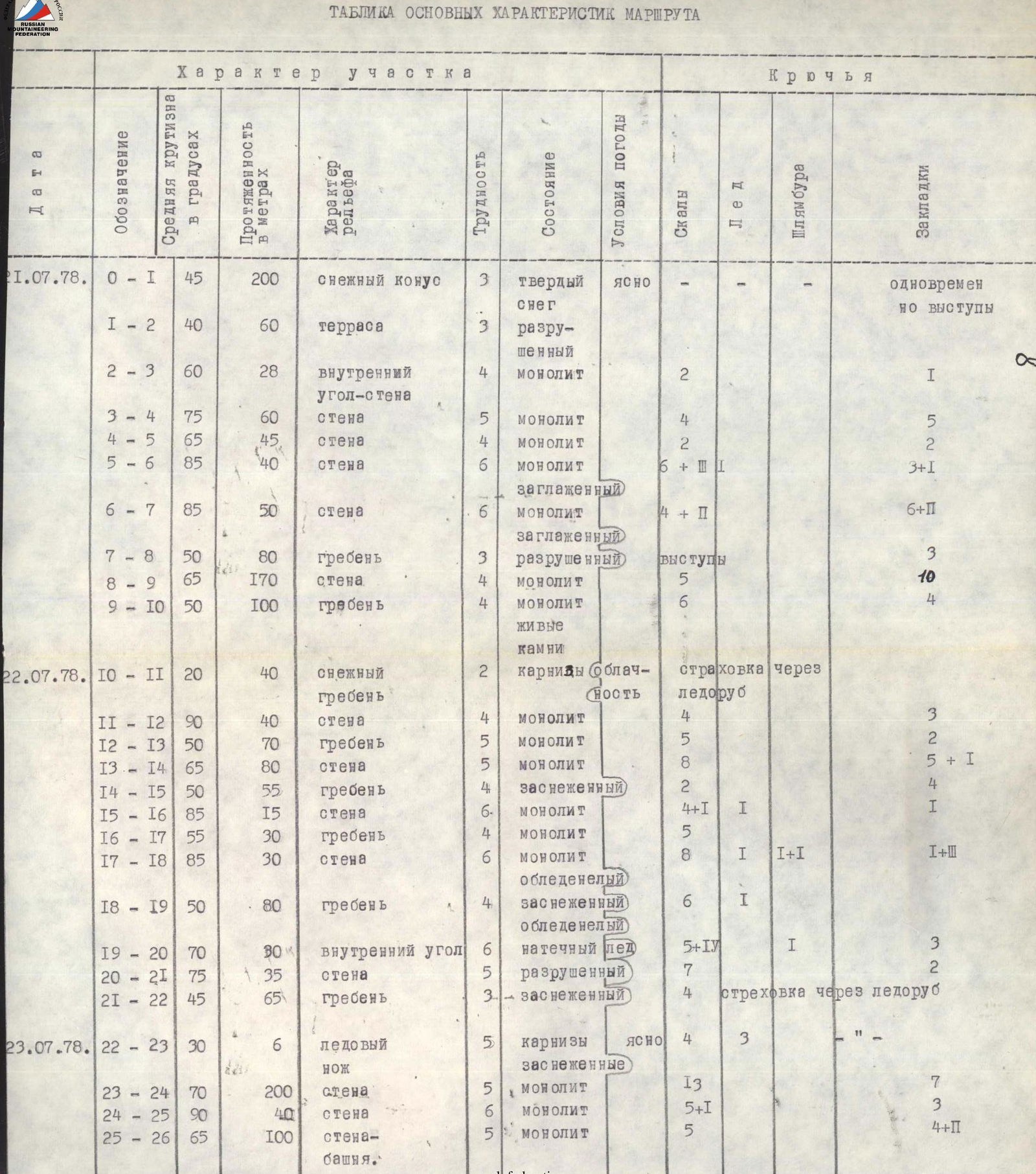
| Date | Designation | Average steepness in degrees | Length in meters | Terrain character | Difficulty | Condition | Weather conditions | Rocks | Ice | Bolts | Chocks |
|---|---|---|---|---|---|---|---|---|---|---|---|
| July 21, 1978 | R0–R1 | 45° | 200 m | snow cone | 3 | hard snow | clear | simultaneously ledges | |||
| R1–R2 | 40° | 60 m | terrace | 3 | destroyed | ||||||
| R2–R3 | 60° | 28 m | inner corner-wall | 4 | monolithic | 2 | 1 | ||||
| R3–R4 | 75° | 60 m | wall | 5 | monolithic | 4 | 5 | ||||
| R4–R5 | 65° | 45 m | wall | 4 | monolithic | 2 | 2 | ||||
| R5–R6 | 85° | 40 m | wall | 6 | monolithic | 6+1 | 3+1 | ||||
| smooth | |||||||||||
| R6–R7 | 85° | 50 m | wall | 6 | monolithic | 4+2 | 6+2 | ||||
| smooth | |||||||||||
| R7–R8 | 50° | 80 m | ridge | 3 | destroyed | ledges | 3 | ||||
| R8–R9 | 65° | 170 m | wall | 4 | monolithic | 5 | 10 | ||||
| R9–R10 | 50° | 100 m | ridge | 4 | monolithic | 6 | 4 | ||||
| loose rocks | |||||||||||
| July 22, 1978 | R10–R11 | 20° | 40 m | snow ridge | 2 | cornices | cloudy | belay via ice axe | |||
| R11–R12 | 90° | 40 m | wall | 4 | monolithic | 4 | 3 | ||||
| R12–R13 | 50° | 70 m | ridge | 5 | monolithic | 5 | 2 | ||||
| R13–R14 | 65° | 80 m | wall | 5 | monolithic | 8 | 5+1 | ||||
| R14–R15 | 50° | 55 m | ridge | 4 | snow-covered | 2 | 4 | ||||
| R15–R16 | 85° | 15 m | wall | 6 | monolithic | 4+1 | 1 | 1 | |||
| R16–R17 | 55° | 30 m | ridge | 4 | monolithic | 5 | |||||
| R17–R18 | 85° | 30 m | wall | 6 | monolithic | 8 | 1 | 1+1 | 1+2 | ||
| icy | |||||||||||
| R18–R19 | 50° | 80 m | ridge | 4 | snow-covered | 6 | 1 | ||||
| icy | |||||||||||
| R19–R20 | 70° | 30 m | inner corner | 6 | flow ice | 5+4 | 1 | 3 | |||
| R20–R21 | 75° | 35 m | wall | 5 | destroyed | 7 | 2 | ||||
| R21–R22 | 45° | 65 m | ridge | 3 | snow-covered | 4 | belay via ice axe | ||||
| July 23, 1978 | R22–R23 | 30° | 6 m | ice "knife" | 5 | cornices | clear | 4 | 3 | “” | |
| snow-covered | |||||||||||
| R23–R24 | 70° | 200 m | wall | 5 | monolithic | 13 | 7 | ||||
| R24–R25 | 90° | 40 m | wall | 6 | monolithic | 5+1 | 3 | ||||
| R25–R26 | 65° | 100 m | wall-tower | 5 | monolithic | 5 | 4+2 |
Brief explanation of the table
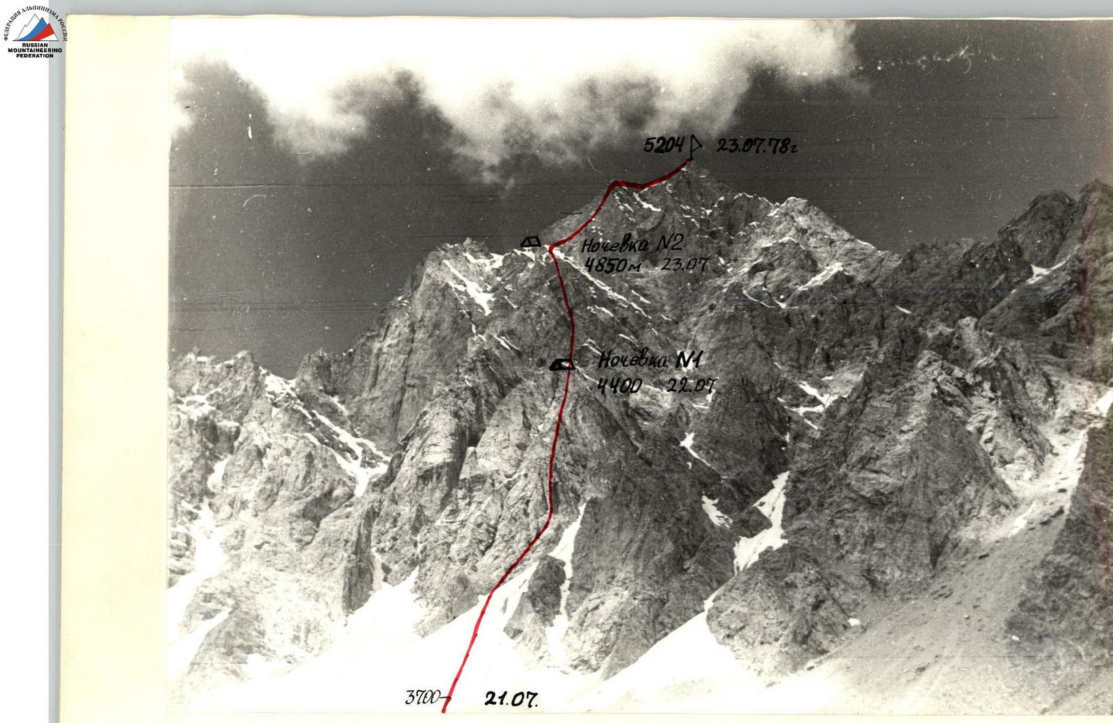
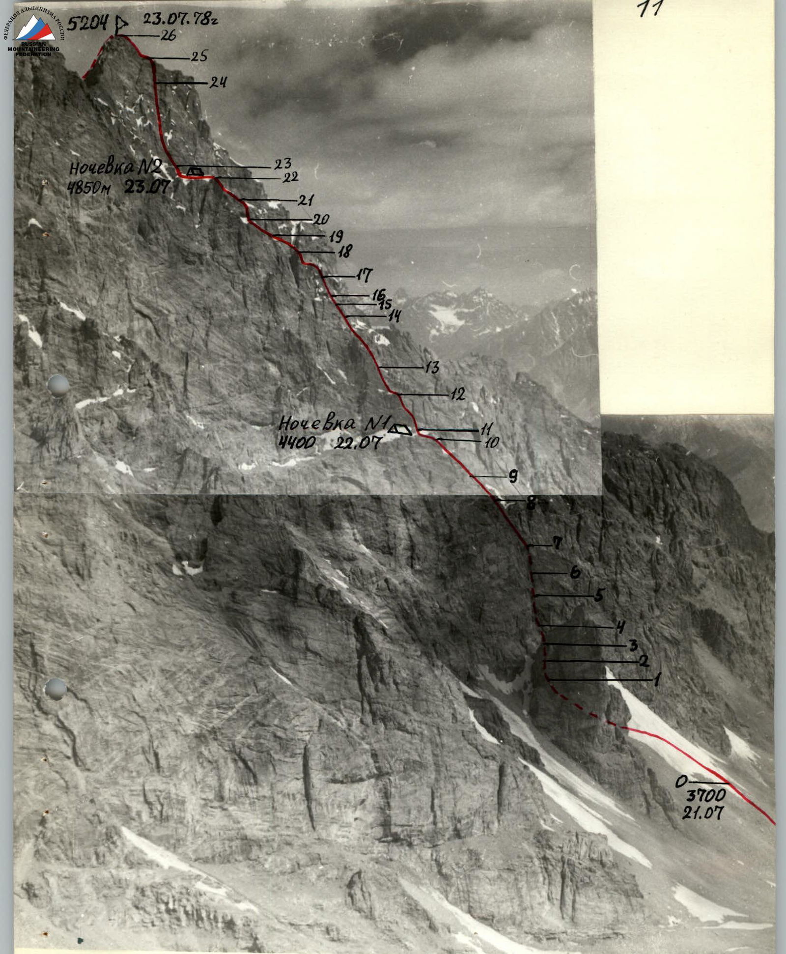
The base of the Eastern wall of peak 5204 m drops into the valley with three clearly defined rock buttresses. The route:
- starts on a snow cone;
- then on the left (orographically) buttress — ascent to the main wall;
- on the main wall — to the pre-summit triangular wall, crowned by a pyramid.
July 21, 1978. Departure from the initial bivouac at 5:00. At 5:30, we begin the ascent up the snow cone to an inclined rock terrace, from which we exit onto the buttress.
Ascent upwards — to the right (in the direction of travel) along smooth black slabs. The route further passes along an overhanging wall (section R5–R6). Difficult climbing, artificial holds, ladders. Rope hauling. After the overhang, to the left and upwards along smooth rocks, exit onto the ridge of the buttress. Here, on a small ledge, is a control cairn. We ascend along the buttress. All walls are climbed directly. In the upper part of the buttress, tense climbing on friction. Along the narrow "saw" of the buttress, overcoming low walls, exit onto a snow-ice saddle connecting the buttress to the main wall of the route. Here we stop for a bivouac at 19:30. The site is cut out in the snow and ice. Walking hours — 13.
July 22, 1978. Before dismantling the bivouac, preliminary processing of the "double" 40-meter wall overhanging the saddle.
After breakfast, the group departs at 8:00. Along a narrow horizontal ledge, move away from the wall to the right in the direction of travel, and then along a wide inner corner steeply upwards. Rocks — monoliths. Along the buttress, we approach one of the key locations — section R15–R16, which represents an icy wall. To pass and organize belaying, it was necessary to cut through flow ice (thick layer up to 5 cm) and ascend using artificial holds and ladders.
Rope hauling. Further along a narrow rocky ridge — exit onto a destroyed, rockfall-prone wall. Traverse with ascent. Caution! Small snow-ice cornices overhang from above. Along snow-covered rocks of medium difficulty, exit onto a snow-ice "knife" with X-shaped cornices. One rope team continues processing the ice "knife" and passes two ropes of the triangular wall. The second team cuts out a platform for a tent in the ice in two hours. Hook belaying of the tent and self-belaying of participants are organized. 21:00.
Walking hours — 12.
July 23, 1978. Departure at 7:30. Along ready-made rope ladders to a small cornice. Further, bypass to the left in the direction of travel along the cornice and along uncomfortable, tile-like rocks steeply upwards. To the right in the direction of travel on the left edge of the wall, a large "sentinel-finger" stands out. Exit under the sentinel along large-block rocks. The sentinel is overcome directly, difficult climbing, rope hauling. Bypassing the sentinel: to the left in the direction of travel — rockfall-prone; to the right — ice cornices.
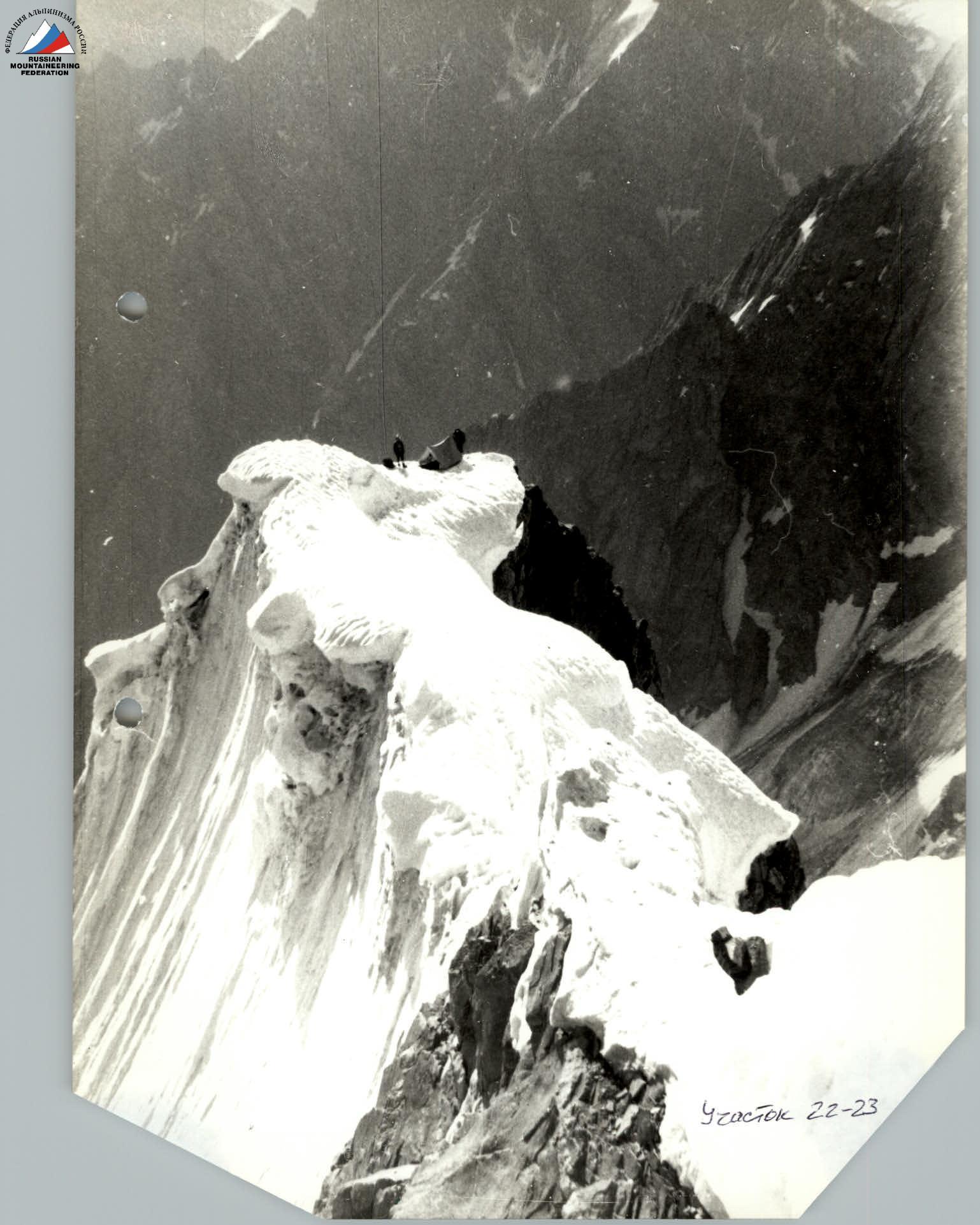
Along a short snow-covered rocky ridge to a 70-meter rocky pyramid — The Summit! 13:30.
Walking hours — 6. Descent from the summit.
Descent began at 15:00 along the northern ridge of the summit in the direction of peak 5100 m. After traversing a 30-meter sentinel, descent along a snow slope and exit onto the edge of rocks leading to a snow col. Along the edge, 1 rappel and 2 abseils. At 18:00, we stopped for a bivouac.
July 24, 1978. At 8:00, we began descent to the west along a narrow, one-and-a-half-kilometer couloir filled with snow and ice in the upper third. We placed 10 rappels of 80 m each.
It is recommended to pass the couloir in the first half of the day due to possible ice and rock falls from the couloir walls when they thaw.
When exiting the couloir:
- stay on the right bank of the Vodjdara River until the snow bridge;
- cross to the left side and follow it to the Base.
14:00.
Conclusion on the route and ascent
The route passed by the group to peak 5204 m via the Eastern wall is combined in its lower part and rocky, with individual ice and snow sections encountered, in the middle and upper parts.
Rocky sections are composed of monolithic, partially smooth rocks. On the route, there are individual destroyed rock sections, which required participants to pass them attentively and clearly.
The route is logical, unambiguous. Good physical and tactical preparation, as well as experience gained this season by the same team on three routes of the highest category of difficulty with similar microrelief, allowed the group to successfully complete this route.
Considering the characteristics of the route passed, its steepness, the large length of sections with 5th and 6th categories of difficulty, as well. as the conclusions of the group made during debriefing and having sufficient experience in passing classified routes of 5B category, we agree with the opinion that the route to peak 5204 m via the Eastern wall corresponds to the 5B category.
Releasing officer from the training camp,
coach, Master of Sports
V. NELUPOV
Lower part of the route profile
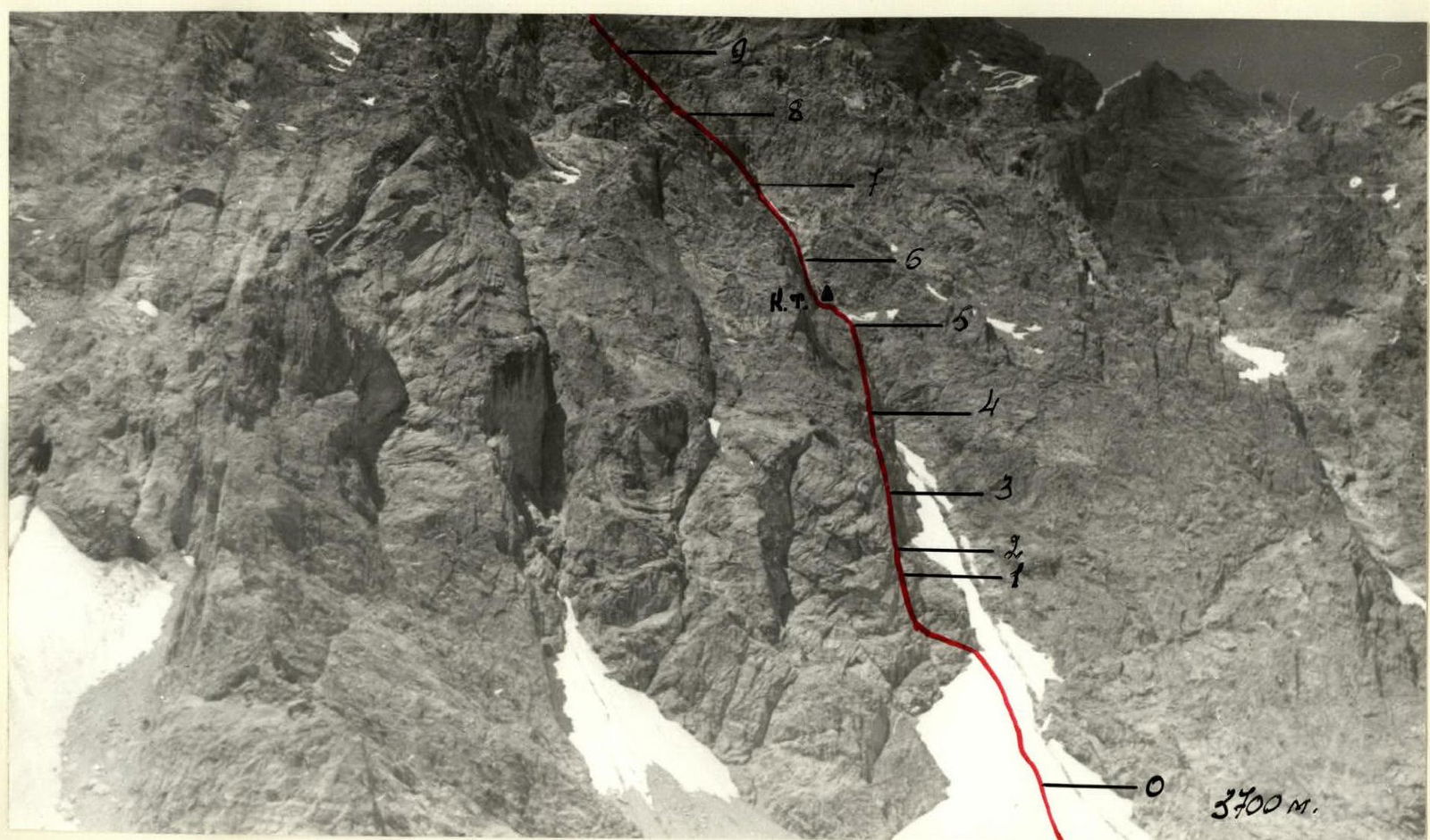
Photo of the route profile