Ascent Passport
- Ascent class: technical.
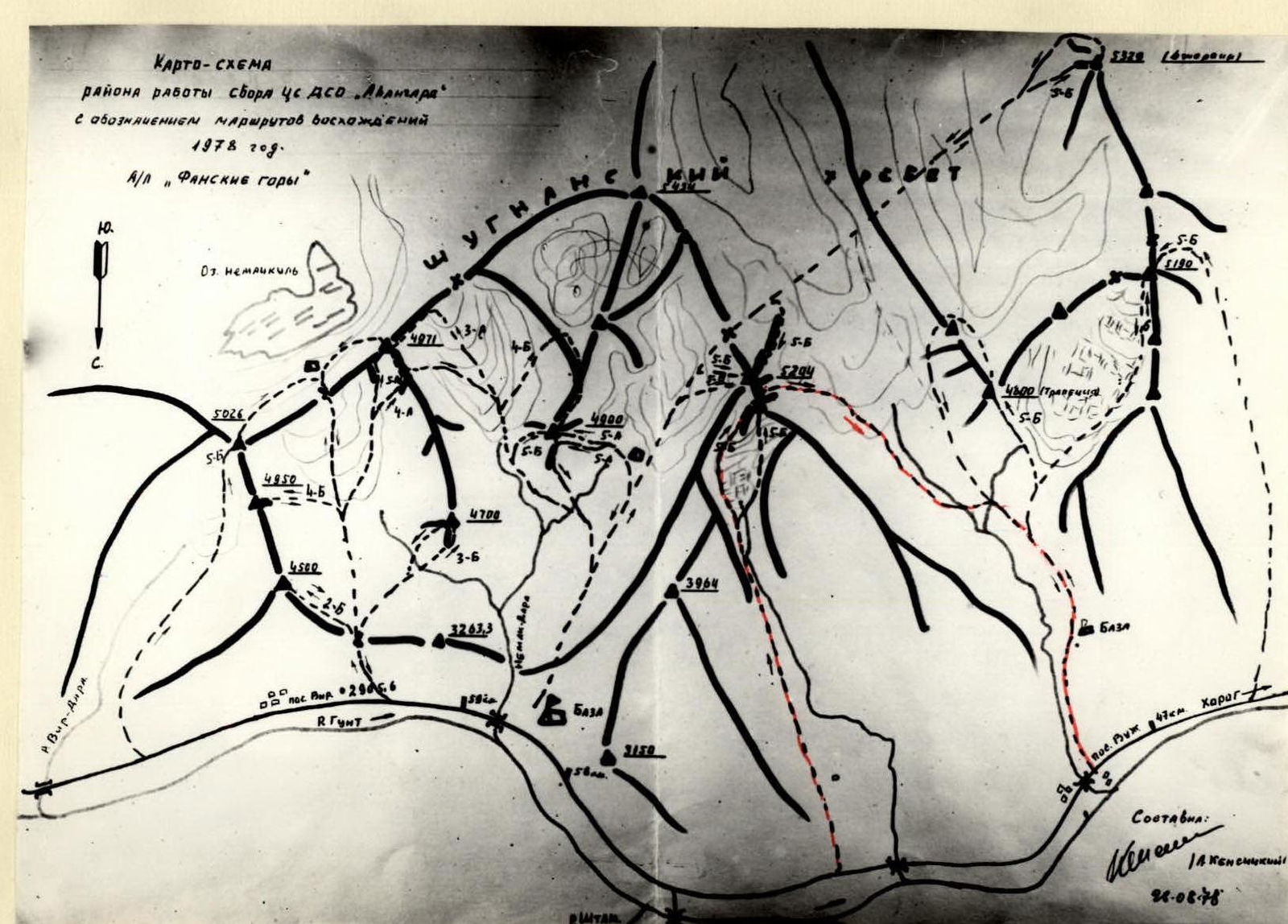
- Ascent area: 10-3 Pamir, North Shugnanskij Ridge.
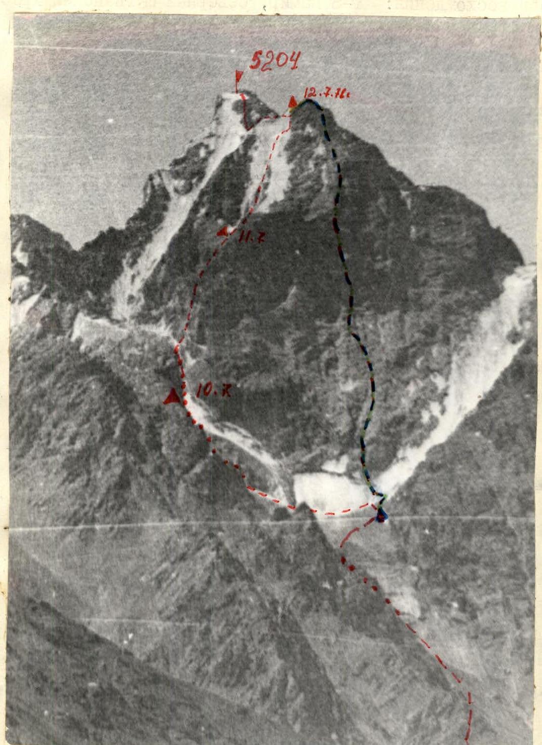
- Peak, height, ascent route: P. 5204 via the left edge of the northern wall.
- Estimated difficulty category: 5B.
- Route characteristics: elevation difference: 1050 m; length of sections with 5–6 difficulty category — 660 m; average steepness — 70°.
- Number of pitons: for belaying: rock — 84; ice — 54. for creating intermediate anchor points: rock — 29; ice — 23.
- Number of climbing hours: 29 h.
- Number of bivouacs on the route and their characteristics: 2 bivouacs on ledges for 2–3 people, 1 on the descent from the summit.
- Full name of the leader, team members, and their qualifications:
- Golubenko M.N. — Candidate Master of Sports,
- Volynskij V.A. — Master of Sports instructor,
- Umanec E.V. — Candidate Master of Sports instructor,
- Kijanica N.N. — Candidate Master of Sports instructor,
- Chub G.I. — Candidate Master of Sports
- Team coach: Kesnickij Leopold Vsevolodovich.
- Date of departure and return:
July 9–12, 1978
 *-- via the left edge of the N. wall --- via the N. wall (Vik. Grishchenko's route)
 www.alpfederation.ru↗
Description of the approach to the north-eastern wall, p. 5204 m
From the 52nd km of the Khorog—Osh road, to the right of two separate houses, up the talus slope to a large boulder. From the large boulder, to the right along the path, exit onto a grassy ridge. Along the ridge to the outcropping rocks, bypassing them on the right. Further along the grassy and talus slopes, crossing a couloir, move in the direction of the glacier tongue. Exit onto the glacier along the right (orographic) moraine. From the highway 3.5–4 h.
The approach to the left edge of the northern wall of 5204 is made via a steep, loose couloir to the left of the icefall onto a rocky shoulder and along rocky ledges to the second step of the icefall. Bivouac under the rocks. The approach from the road to the bivouacs takes 5–6 h.
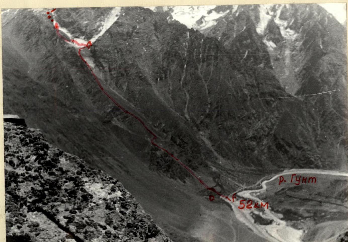
Table of main characteristics of the ascent route
Ascent route: p. 5204 via the left edge of the N. wall.
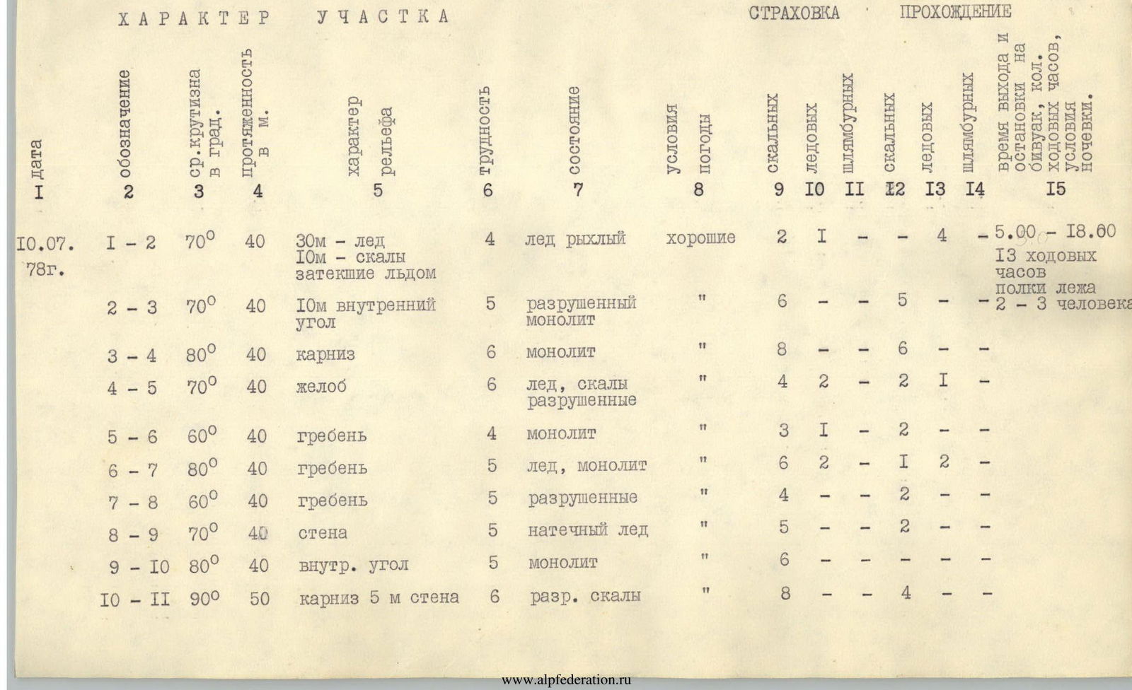
| Date | Designation | Avg. steepness | Length, m | Terrain characteristics | Difficulty | Condition | Conditions | Rock | Ice | Bolts | Ice screws | Climbing hours | Bivouacs |
|---|---|---|---|---|---|---|---|---|---|---|---|---|---|
| 10.07.1978 | R1–R2 | 70° | 40 | 30 m — ice, 10 m — rocks, frozen with ice | 4 | ice is friable | good | 2 | 1 | - | - | from 5:00 to 18:00, 13 climbing h, lying ledges, 2–3 people | - |
| R2–R3 | 70° | 40 | 10 m internal corner | 5 | destroyed monolith | «» | 6 | - | - | 5 | - | ||
| R3–R4 | 80° | 40 | cornice | 6 | monolith | «» | 8 | - | - | 6 | - | ||
| R4–R5 | 70° | 40 | gully | 6 | ice, destroyed rocks | «» | 4 | 2 | - | 2 | 1 | ||
| R5–R6 | 60° | 40 | ridge | 4 | monolith | «» | 3 | 1 | - | 2 | - | ||
| R6–R7 | 80° | 40 | ridge | 5 | ice, monolith | «» | 6 | 2 | - | 1 | 2 | ||
| R7–R8 | 60° | 40 | ridge | 5 | destroyed | «» | 4 | - | - | 2 | - | ||
| R8–R9 | 70° | 40 | wall | 5 | ice forming | «» | 5 | - | - | 2 | - | ||
| R9–R10 | 80° | 40 | internal corner | 5 | monolith | «» | 6 | - | - | - | - | ||
| R10–R11 | 90° | 50 | cornice, 5 m wall | 6 | destroyed rocks | «» | 8 | - | - | 4 | - | ||
| 11.07.1978 | R11–R12 | 50° | 40 | ridge | 4 | destroyed | good | 4 | - | - | - | from 8:00 to 19:00, 11 climbing h, lying ledges, 2–3 people | - |
| R12–R13 | 70° | 360 | ice wall, 5 | 5 | ice | «» | - | 40 | - | - | 12 | - | |
| R12–R13 | 80° | 60 | ice wall, 5 | 5 | ice | «» | - | 8 | - | - | 4 | - | |
| R13–R14 | 80° | 80 | wall, 5 | 5 | destroyed rocks | «» | - | 12 | - | - | 5 | - | |
| 12.07.1978 | R14–R15 | 60° | 160 | wall, 5 | 5 | slabs | «» | - | 16 | - | - | - | - |
Explanations
To the table of main characteristics of the ascent route
Section R0–R1
Description of the approach. From the bivouacs, up the snow-ice slope for 1.5 h to the approach under the ice couloir (which is crossed from left to right upwards) with an avalanche cone in its lower part and a bergschrund.
Section R1–R2
To the right upwards through the bergschrund, we cross the ice couloir with a steepness of 70–80% in the direction of the talus ledge 40 m. Section R1–R2 is climbed until 7:00 am due to avalanche and rockfall danger.
Section R2–R3
Upwards along the rocky rib, exit into an internal corner 10 m, overhanging in the upper part, along the internal corner, exit onto a ledge at the base of a gully leading to the northern edge. The length of the section is 40 m, climbing is difficult.
Section R3–R4
Along the edge of the slab, to the left of the gully, exit under the cornice, through it, exit onto the turn of the gully. The cornice is passed using ladders. The length of the section is 40 m. Steepness 70–80% up to the cornice and above.
Section R4–R5
Further, transition of the gully from left to right, from the turn and to the exit onto the ridge, the gully is filled with ice and snow, 10 m on ice and 30 m on smooth rocks. There are very few cracks for pitons. Steepness of the section is 70–80%. Steepness 70–80% up to the cornice and above.
Section R5–R6
Along the boundary of ice and rocks, exit onto the ridge. 20 m from point "5", transition through an overhanging snow-ice wall 5 m. Length 40 m. Steepness 60–95°.
Section R6–R7
Further 10 m approach along the boundary of ice and rocks, exit onto the ridge and 30 m along the ridge. Steepness of the 10 m section is 80–90%. To the right of the ridge, there is a platform. The first 10 m climbing is difficult.
Section R7–R8
To the left upwards along the ridge along destroyed rocks to the beginning of a steep descent, steepness of the section is 60–80°. Climbing is of medium difficulty 40 m.
Section R8–R9
To the right upwards along the wall under the lower edge of the snowpatch, exit onto grey slabs, transition dirt-grit and water on rocks – 20 m. Further exit along loose rocks to the beginning of two converging internal corners 20 m. The first internal corner is filled with ice. Steepness 70–90°.
Section R9–R10
Along the left internal corner upwards 30 m under the overhanging part. Traverse to the right-upwards along cracks under the cornice in the upper part of the right internal corner. The length of the section is 40 m, average steepness 80–90°.
Section R10–R11
Transition through the cornice using ladders 5 m. 50 m upwards along difficult rocks leading to the ridge. Here to the left along the ridge is a bivouac site.
Section R11–R12
Further along the left part of the ridge along destroyed rocks 200 m, exit under the base of the snow-ice knife going upwards to the saddle. Climbing is of medium difficulty.
Section R12–R13
Upwards along the ice-snow slope with a steepness of 70–80% (in the lower third 70%) 360 m upwards in 12 ice screws with the use of ice screws. Further traverse along the ice 60 m to the right onto the rocks of the summit bastion of the northern summit.
Section R13–R14
Upwards along strongly destroyed difficult rocks onto the snow saddle. Steepness 75–85°. On the south-western side on rocky ledges is a bivouac.
Section R14–R15
Further along the boundary of snow and rocks 100 m descent onto the saddle between the main and northern summit. 160 m along inclined rocky slabs with a minimal number of holds, exit onto the main summit. Steepness 70–75°. Climbing is difficult on friction.
Descent from the summit
Carried out by 4 sport rappels onto the saddle along the ascent route, and further downwards along the ice-snow couloir into the valley of the Vuzh river. Along the left (orographic) slope of the river, exit to the village of Vuzh.


