
Ascent Passport
- CATEGORY — High-altitude technical
- REGION — South-Western Pamir, Shugnan Range
- PEAK — Vodzh peak 5434 m first ascent via the counterfort of the northeastern wall
- PROPOSED difficulty category — 5B
- HEIGHT DIFFERENCE — 1065 m LENGTH of sections with 5–6 difficulty category — 600 m. AVERAGE slope — 62°.
- PITS DRIVEN: For belaying: For creating ITO Ice 22: 1 Rock 57: 6 Bolts: Used 64: 8 chocks
- NUMBER of climbing hours (for ascent) — 28
- NIGHTS on the route — TWO, both comfortable, with water
- Captain: 1. KAYGORODTSEV
Sergey Aleksandrovich — CMS
Participants:
- 2. KOCHERGA Yury Ivanovich — CMS
-
- MOSIICHUK Igor Grigorievich — CMS
-
- SHIDLOVSKY Sergey Vladislavovich — CMS Trainer: TARKHANOV Vladimir Grigorievich — MS
- DATES of departure and return — 23–26 August 1983
Chelyabinsk Alpine Federation
1983 year
www.alpfederation.ru ↗
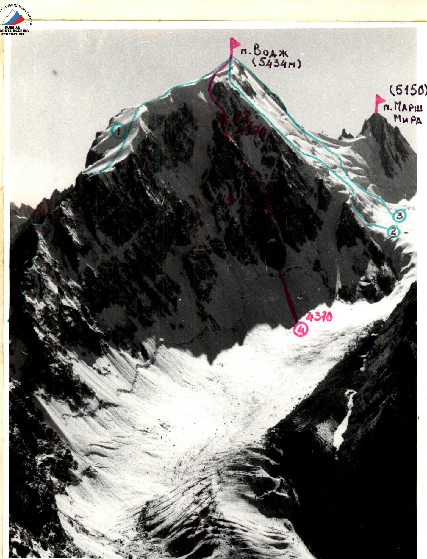
GENERAL PHOTO OF THE PEAK. PHOTOGRAPHY on August 15, 1983 at 18:00 from the ridge of p. 4971. Height 4750 m. LENS
"HELIOS-44". f=58 mm. 1 — P.V. orient. ZA on the eastern slope, V. TARKHANOV+5
2 — or. 5A on the left edge of the N. wall, Yu. KOCHERGA
3 — or. 5A on the right edge of the N. wall, A. FEDYAEV+3
www.alpfederation.ru ↗ — PROPOSED ROUTE
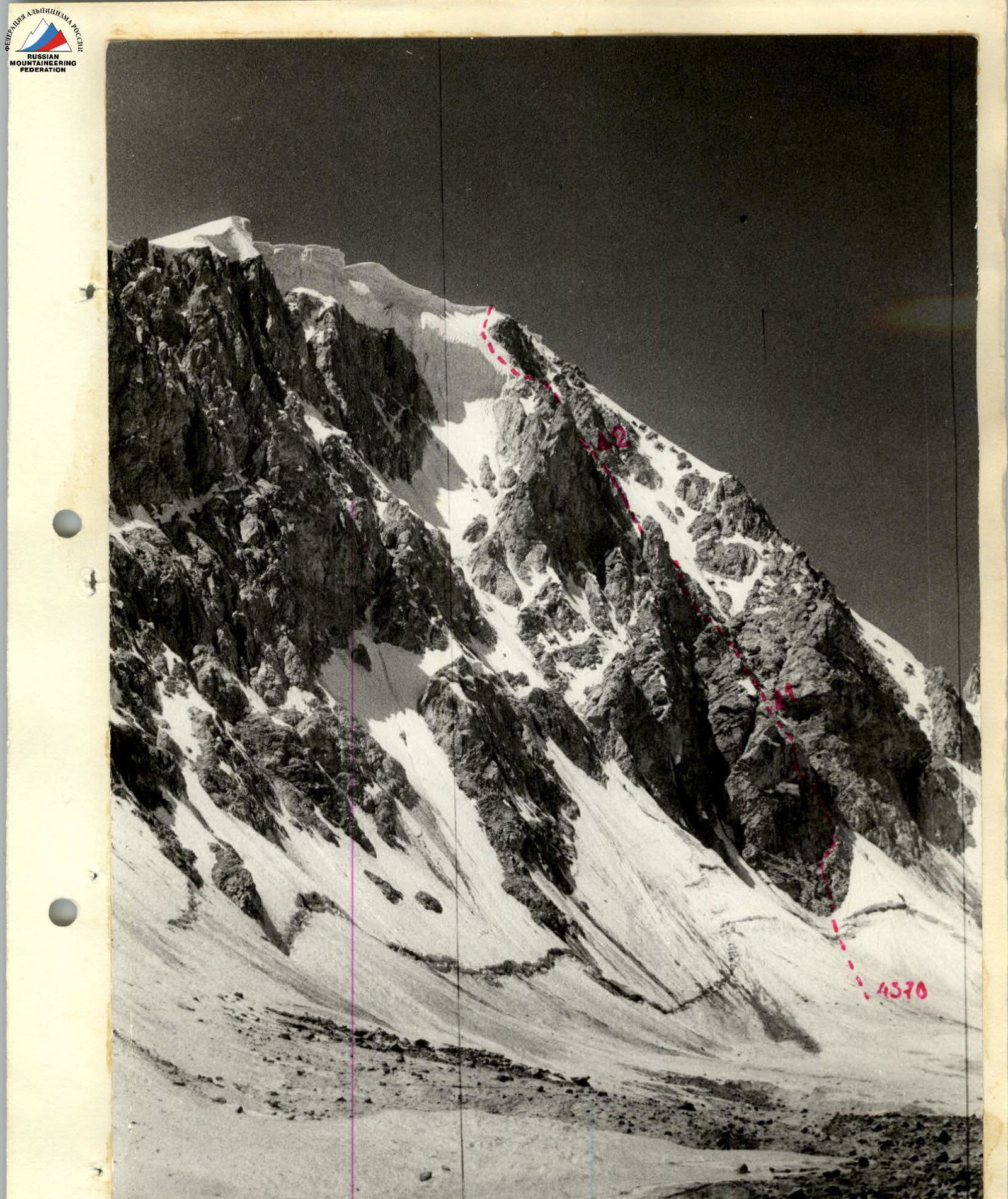
Photo 2: Profile of the NE wall of p. Vodzh from the east. PHOTOGRAPHY FROM THE GLACIER. Height — 4380 m.
August 21, 1983, 13:00. LENS "Helios-44". f=58 mm.
 Right profile of the NE wall of p. Vodzh. Photography from the top of Gondorak on August 23, 1983 at 18:00 (5200) Helios-44 f=58 mm

Left profile of the NE wall of p. Vodzh. Photography from the ridge of p. 4971 — on August 14, 1983 at 9:30 (4900) Helios-44 f=58 mm.

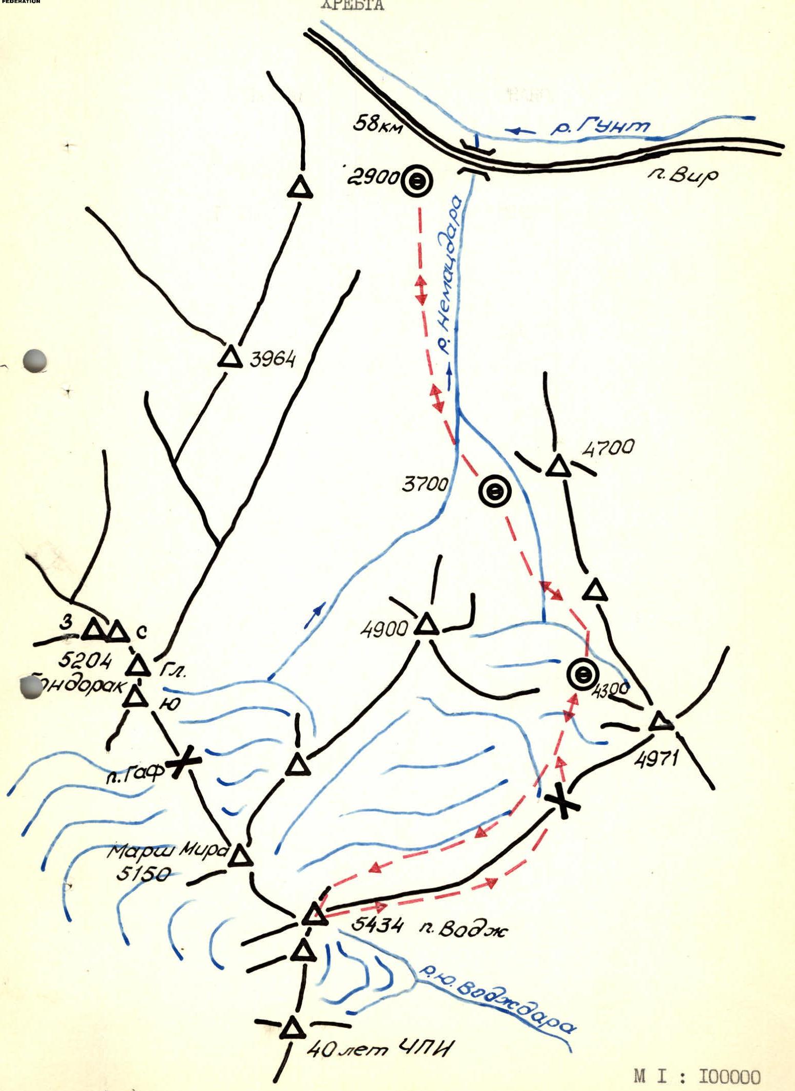
Scaled Carto-Scheme of the North Shugnan Range
This is the third region developed by Chelyabinsk climbers (1957–1966 — Karakol, 1975–1983 — Kisil-Aliay). Many know that the Chelyabinsk Regional Alpine Federation, in contact with the regional military commissariat, has established year-round training for conscripts to serve at high-mountain outposts of our Motherland, annually sending 300–350 of its trainees to the border troops in the autumn after training them in the mountains in winter and spring 3–5 times. The work of Chelyabinsk climbers within the framework of contacts established with the Topographic Complex Expedition No. 222 was of a similar, if not greater, scope: for four years, the best athletes in the region ensured the success of correcting old topographic references from satellite images and some resurveying. The Shugnan Range was not overlooked, but descriptions were not made; the only exception: a group led by K. Vifbalis, consisting of Lithuanian and Chelyabinsk climbers, submitted descriptions of their first ascents from the south to peaks Kaunas and Maifronisa to the Alpine Federation of the USSR (1977).
Alpinist exploration of the region began in the following year, 1978 — but not by Chelyabinsk climbers or Lithuanians, but by a powerful team from the Alay alpine camp led by V. Kavunenko and a friendly team from "Avangard", whose leader, Leopold Vsevolodovich Kensitsky, provided invaluable assistance during preparation, and MS P. Slavininsky shared descriptions. Efforts by these collectives classified routes to peaks Vir, Gondorak, Dzheraim, Crystal, Trapezia, and others in the area between the villages of Vir and Vuzh (Vodzh).
We note inaccuracies in section 4.13 of the "Classification Table of Routes": a) No. 2 "Gondorak 5A rock via the left edge of the N. wall" and No. 7 "Gondorak West 5A rock via the counterfort of the N. wall", climbed by A. Zybin (Moscow Spartak), are the same COMBINED route. The western peak of Gondorak, in our opinion, is not independent (the ridge is small and not deep). b) No. 13 "Maifronisa" and No. 14 "5150" are the same peak "5155", on which there is a geodetic sign, disappointing the group of Odessans led by I. Orobei, who ascended the NW wall with the aim of giving the "nameless peak" the name of the Heroes of Potemkin.
Access to the region is through Osh to Djilanandy and then to the village of Vir — 670 km. The second access option: through Dushanbe-Khorog — 580 km, in our opinion less preferable, although shorter. The attached carto-scheme clearly shows that the approaches in this area are clear and small. From the base camp "2900", located in an willow grove on the western outskirts of the village of Vir, to the start of the route, the approach takes 5–5.5 hours and goes first up the Nematsdara river and then bypassing peak "4900" on the left along the orographic right part of the glacier flowing from the northern slopes of p. Vodzh. www.alpfederation.ru ↗
Tactical Actions of the Team
The tactical plan, drawn up on the eve of the ascent based on the results of reconnaissance, included the following positions:
- Time breakdown:
- August 22, 1983 12:00 — departure from base camp "2900" 16:00 — arrival at assault camp "4300", overnight stay
- August 23, 1983 6:30 — departure from camp "4300" 8:00 — start of work on the route 19:00 — passage of the 1st bastion, stop for the night
- August 24, 1983 19:00 — passage of the 2nd bastion, stop for the night
- August 25, 1983 13:00 — exit to the Eastern ridge 15:00 — exit to the summit 18:00 — descent along the Eastern ridge to camp "4300"
- August 26, 1983 12:00 — descent to base camp "2900"
- Breakdown by rope teams:
- KOCHERGA Yu. — MOSIICHUK I. — attacking rope team
- KAYGORODTSEV S. — SHIDLOVSKY S.
- The first in the attacking rope team works on a double rope on the wall section of the route.
- Emergency descent from the wall section of the route — along the ascent route.
- Each rope team has its own individual first-aid kit.
- Radio communication with the base camp at even hours from 8:00 to 20:00 The planned tactical plan was largely executed, with no deviations from the movement schedule. On sections R3–R24, the first climber worked on a double rope. On complex sections (R3, R5–R9, R13–R17, R19), fixed ropes were organized, and climbers moved on jumars with top belay. The first in the attacking rope team alternated when passing key sections of the route: KOCHERGA Yu. — sections R3, R8, R9, R13, R15, R16, R19; MOSIICHUK I. — R5–R7, R14, R17. Starting from section R25, the attacking rope team was changed. Gear was transported using a shuttle method. On August 23 and 24 at 13:00, a short break was taken for a snack (canned fish, lard, condensed milk). Each team member had a pocket snack (chocolate, dried fruits) during the ascent. Both overnight stays on the route were in tents, with platforms made of stone. Radio communication with the base camp and observers was stable and timely. There were no missed communication sessions. There were no falls or injuries on the route. www.alpfederation.ru ↗
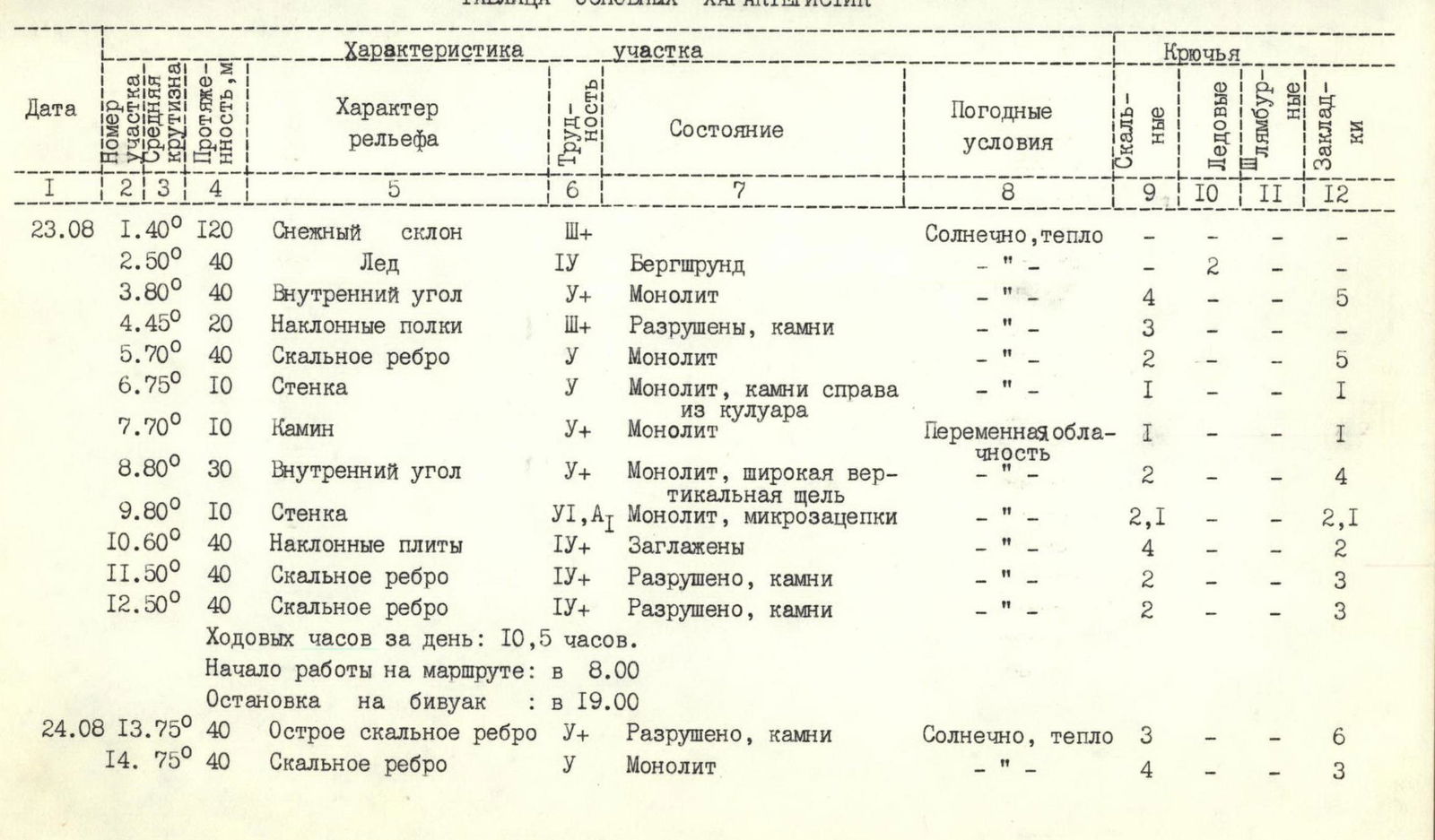
Table of Main Characteristics
| Date | Height Difference | Average Slope | Length | Terrain Character | Difficulty | State | Weather Conditions | Pitons |
|---|---|---|---|---|---|---|---|---|
| Rock Pitons | ||||||||
| 23.08 | 1.40° | 120 | Snow slope | 3 | Sunny, warm | |||
| 2.50° | 40 | Ice | 4 | Bergschrund | " | 2 | ||
| 3.80° | 40 | Inner corner | 5 | Monolith | " | 4 | ||
| 4.45° | 20 | Inclined shelves | 3 | Destroyed, stones | " | 3 | ||
| 5.70° | 40 | Rock rib | 5 | Monolith | " | 2 | ||
| 6.75° | 10 | Wall | 5 | Monolith, stones on the right from the couloir | " | 1 | ||
| 7.70° | 10 | Chimney | 5 | Monolith | Partly cloudy | 1 | ||
| 8.80° | 30 | Inner corner | 5 | Monolith, wide vertical slot | " | 2 | ||
| 9.80° | 10 | Wall | 6 | Monolith, micro-holds | " | 2,1 | ||
| 10.60° | 40 | Inclined slabs | 4 | Smooth | " | 4 | ||
| 11.50° | 40 | Rock rib | 4 | Destroyed, stones | " | 2 | ||
| 12.50° | 40 | Rock rib | 4 | Destroyed, stones | " | 2 | ||
| 24.08 | 13.75° | 40 | Sharp rock rib | 5 | Destroyed, stones | Sunny, warm | 3 | |
| 14.75° | 40 | Rock rib | 5 | Monolith | " | 4 | ||
| Hours worked per day: 10.5 hours. | ||||||||
| Start of work on the route: at 8:00 | ||||||||
| Stop for bivouac: at 19:00 | ||||||||
 | ||||||||
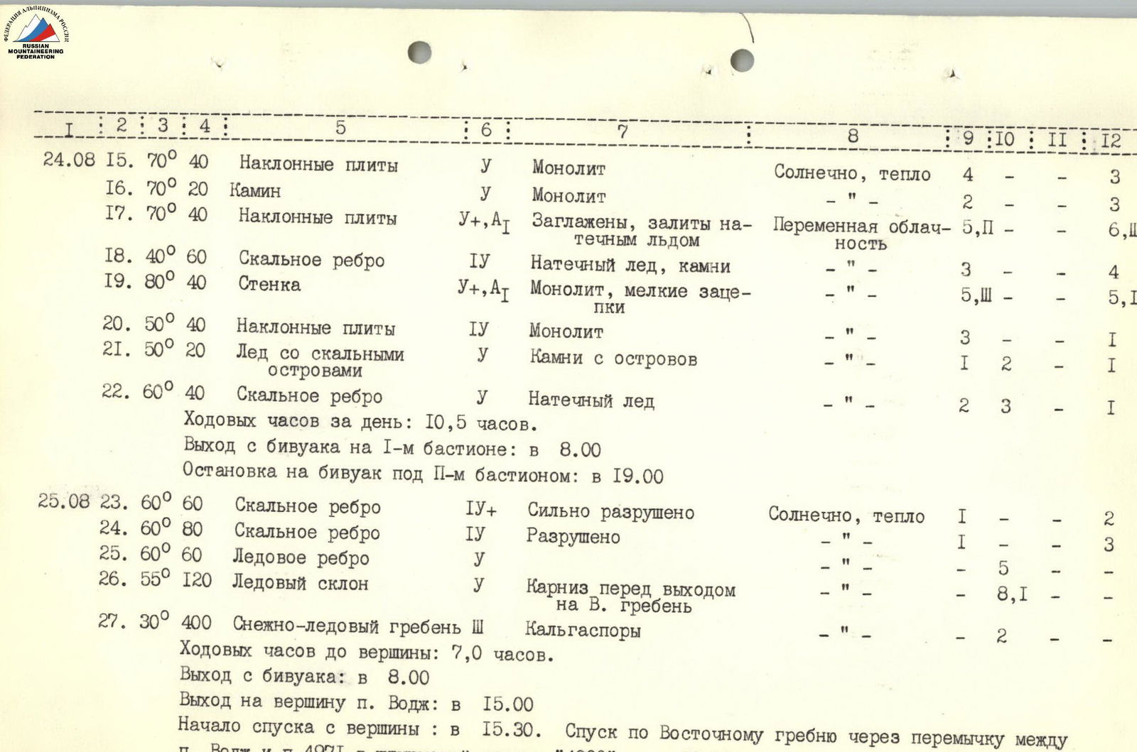 |
| 24.08 | 15.70° | 40 | Inclined slabs | 5 | Monolith | Sunny, warm | 4 | 3 | |||
| 16.70° | 20 | Chimney | 5 | Monolith | " | 2 | 3 | ||||
| 17.70° | 40 | Inclined slabs | 5 | Smooth, covered with rime ice | Partly cloudy | 5, P | 6, Ш | ||||
| 18.40° | 60 | Rock rib | 4 | Rime ice, stones | " | 3 | 4 | ||||
| 19.80° | 40 | Wall | 5 | Monolith, small holds | " | 5, Ш | 5, 4 | ||||
| 20.50° | 40 | Inclined slabs | 4 | Monolith | " | 3 | 1 | ||||
| 21.50° | 20 | Ice with rock outcrops | 4 | Stones from outcrops | " | 1 | 2 | 1 | |||
| 22.60° | 40 | Rock rib | 5 | Rime ice | " | 2 | 3 | 1 | |||
| Hours worked per day: 10.5 hours. | |||||||||||
| Departure from bivouac on the 1st bastion: at 8:00 | |||||||||||
| Stop for bivouac under the 2nd bastion: at 19:00 | |||||||||||
| 25.08 | 23.60° | 60 | Rock rib | 4 | Severely destroyed | Sunny, warm | 1 | 2 | |||
| 24.60° | 80 | Rock rib | 4 | Destroyed | " | 1 | 3 | ||||
| 25.60° | 60 | Ice rib | 5 | " | 5 | ||||||
| 26.55° | 120 | Ice slope | 5 | Cornice before exit to the E. ridge | " | 8,1 | |||||
| 27.30° | 400 | Snow-ice ridge | 3 | Cornices | " | 2 | |||||
| Hours worked to the summit: 7.0 hours. | |||||||||||
| Departure from bivouac: at 8:00 | |||||||||||
| Exit to the summit of p. Vodzh: at 15:00 | |||||||||||
| Start of descent from the summit: at 15:30. Descent along the Eastern ridge through the saddle between | |||||||||||
| p. Vodzh and p. 4971 to assault camp "4300" — at 18:00 | |||||||||||
| www.alpfederation.ru ↗ | |||||||||||
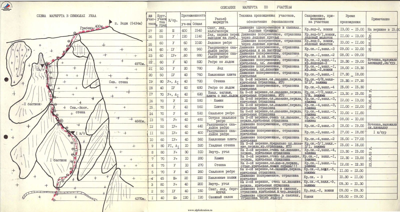 |
Description of the Route by Sections
| Section No. | Slope in Degrees | Length of Section | Total Length | Terrain of the Route | Technique for Passing Sections, Safety Measures | Equipment Used on Sections | Time Taken | Note |
|---|---|---|---|---|---|---|---|---|
| R27 | 30 | 3 | 400 | 1540 | Snow, ice, cornices | Simultaneous movement in rope teams. Ice crevasses! | Ice ax-4, crampons | 13:00–15:00 |
| R26 | 55 | 5 | 120 | 1140 | Ice, cornice before exit to the ridge | Alternating movement, belay via ice screws | Ice ax-9/1, crampons, ice hammer | 11:00–13:00 |
| R25 | 60 | 5 | 60 | 1020 | Ice rib | Alternating movement, screw and outcrop belay | Ice ax-5, crampons, ice hammer | 10:00–11:00 |
| R24 | 60 | 4 | 80 | 960 | Destroyed rock rib | Alternating movement, screw and outcrop belay | Rock piton-1, chock-3 | 09:00–10:00 |
| R23 | 60 | 4 | 60 | 880 | Destroyed rock rib | Alternating movement, screw and outcrop belay | Rock piton-1, chock-2 | 08:00–09:00 |
| R22 | 60 | 5 | 40 | 820 | Rib with ice | Alternating movement: screw belay, difficult climbing | Rock piton-1, chock-1, ice ax-2, crampons | 18:30–19:00 |
| R21 | 50 | 5 | 20 | 780 | Ice | Alternating movement, screw belay | Rock piton-1, chock-1, ice ax-2 | 18:00–18:30 |
| R20 | 50 | 4 | 40 | 760 | Inclined slabs | Alternating movement, screw belay | Rock piton-3, chock-1 | 17:30–18:00 |
| R19 | 80 | 5 | 40 | 720 | Wall | Double rope, difficult climbing, fixed ropes, ITO | Rock piton-7/P, chock-7/P, jumars | 15:30–17:30 |
| R18 | 40 | 4 | 60 | 680 | Rib with ice | Alternating movement, belay | Rock piton-3, chock-4 | 15:00–15:30 |
| R17 | 70 | 5 | 40 | 620 | Inclined, smooth slabs with rime ice | Double rope, difficult climbing, fixed ropes, ITO | Rock piton-7/P, chock-7/P, jumars | 13:30–15:00 |
| R16 | 70 | 5 | 20 | 580 | Chimney | Double rope, difficult climbing, fixed ropes | Rock piton-4, chock-3, jumars | 13:00–13:30 |
| R15 | 70 | 5 | 40 | 560 | Slabs | Double rope, difficult climbing, fixed ropes | Rock piton-4, chock-3, jumars | 11:00–12:00 |
| R14 | 70 | 5 | 40 | 520 | Rock rib | Double rope, difficult climbing, fixed ropes | Rock piton-4, chock-3, jumars | 10:00–11:00 |
| R13 | 75 | 5 | 40 | 480 | Sharp rock rib | Double rope, very difficult climbing, fixed ropes | Rock piton-3, chock-6, jumars | 08:00–10:00 |
| R12 | 50 | 4 | 40 | 440 | Destroyed rock rib | Alternating movement, screw belay | Rock piton-2, chock-3 | 18:00–19:00 |
| R11 | 50 | 4 | 40 | 400 | Destroyed rock rib | Alternating movement, screw belay | Rock piton-2, chock-3 | 17:00–18:00 |
| R10 | 60 | 4 | 40 | 360 | Inclined slabs | Alternating movement, screw belay | Rock piton-4, chock-2 | 16:00–17:00 |
| R9 | 80 | 6 | 10 | 320 | Smooth wall | Double rope, extremely difficult climbing, fixed ropes, ITO | Rock piton-3/1, chock-3/1, jumars | 15:00–16:00 |
| R8 | 80 | 5 | 30 | 310 | Inner corner | Double rope, very difficult climbing, fixed ropes | Rock piton-2, chock-4, jumars | 13:30–15:00 |
| R7 | 70 | 5 | 10 | 280 | Chimney | Double rope, very difficult climbing, fixed ropes | Rock piton-1, chock-1, jumars | 12:30–13:00 |
| R6 | 75 | 5 | 10 | 270 | Wall | Double rope, difficult climbing, fixed ropes, stones on the right!!! | Rock piton-1, chock-1, jumars | 12:00–12:30 |
| R5 | 70 | 5 | 40 | 260 | Rock rib | Alternating movement, screw belay | Rock piton-2, chock-5, jumars | 11:00–12:00 |
| R4 | 45 | 3 | 20 | 220 | Inclined shelves | Alternating movement, screw belay | Rock piton - 3 | 10:30–11:00 |
| R3 | 80 | 5 | 40 | 200 | Inner corner | Double rope, very difficult climbing, fixed ropes | Rock piton-4, chock-5, jumars | 09:30–10:30 |
| R2 | 50 | 4 | 40 | 160 | Snow, ice, bergschrund | Alternating movement in rope teams, belay via ice screw and ice axe | Ice ax-2, crampons | 09:00–09:30 |
| R1 | 40 | 3 | 120 | 120 | Snow slope | Simultaneous movement in rope teams, belay via ice axe | Crampons | 08:00–09:00 |
| www.alpfederation.ru ↗ | ||||||||
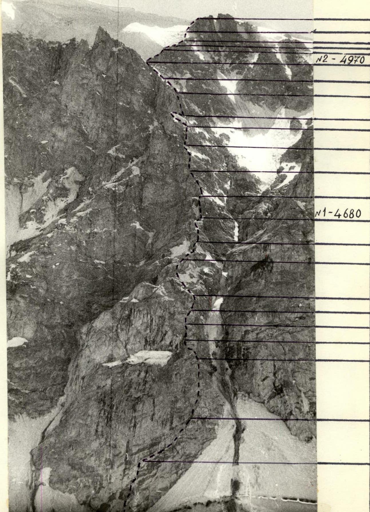 |
Photo 3: Technical photograph of the route. PHOTOGRAPHY on August 21, 1983 at 15:00 from the left
moraine of the glacier. Height 4400 m. LENS "Helios-44", f=58 mm.
www.alpfederation.ru ↗

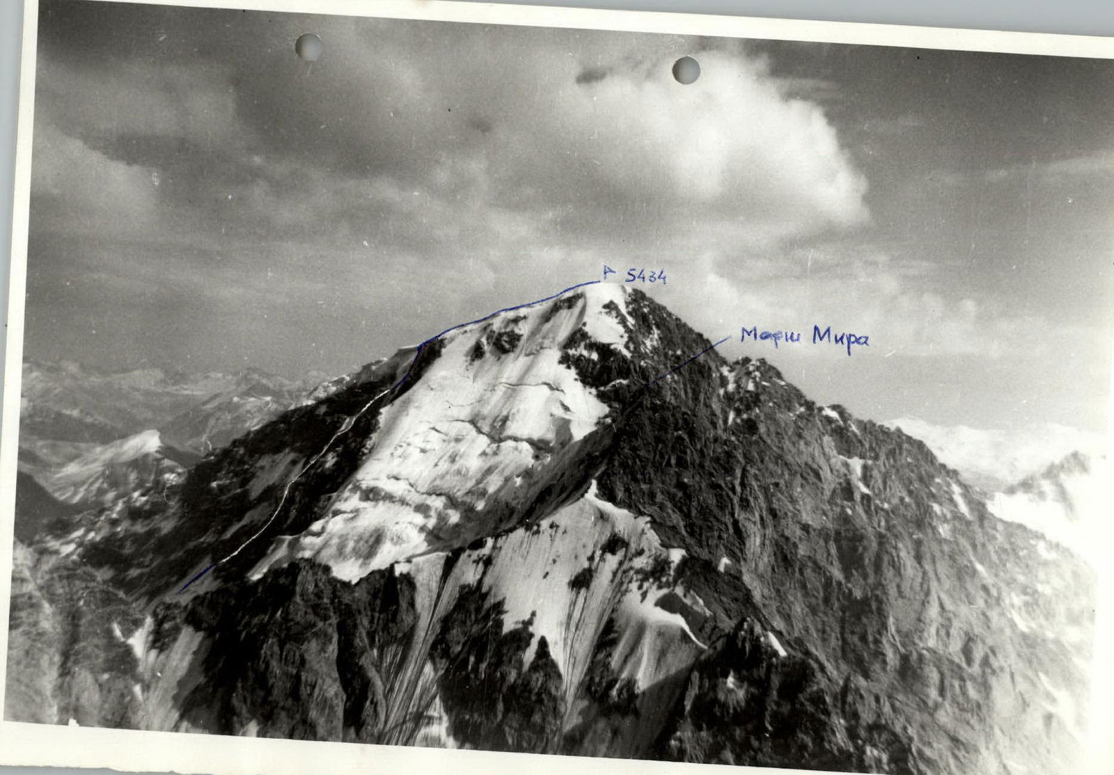
Photo 4: GENERAL VIEW OF THE ROUTE www.alpfederation.ru ↗
Comments
Sign in to leave a comment