Ascent Passport
- Class — High-altitude technical
- South-West Pamir, North Shugnan Range, Nematzdara valley
- Vodzh peak, 5434 m, via the North face through Marsh Mira pass
- Proposed category of complexity — 5A cat. diff., snow-ice
- Height difference: 780 m, length 1170 m, length of 5th category sections — 410 m, average steepness of main sections — 51° (5170–5410) 49° (4694–5080)
- Pitons driven: protection and ITO rock — bolt — ice — 121, ITO — 2
- Number of travel hours — 11 hours
- No overnight stays
- Fedyaev Alexey Leonidovich — 1st sports category, leader Vakhitov Talgat Kamilevich — 2nd sports category Karpenkov Mikhail Vladimirovich — 2nd sports category Ryabukhin Alexander Grigorievich — Master of Sports Stepanov Sergey Igorevich — 2nd sports category
- Coach — Honored Coach of the RSFSR, Master of Sports Ryabukhin A.G.
- Approach to the route — August 19, 1983 Return — August 19, 1983
— group route first ascent 5A category via N face through Marsh Mira pass (August 19, 1983)
— 5A via the left edge of N face first ascent (1983) by Yu. Kocherga (sorry for inaccurate representation — see p. 20)
— 5B via N-E face first ascent (1983) by S. Kaygo
— 3A via E ridge first ascent (1983) by V. Tarkhanov
— Marsh Mira (5170)
— 4A via N ridge first ascent (1983)
— 40 Let ChPI (5070)
— 3A via N ridge (1983)
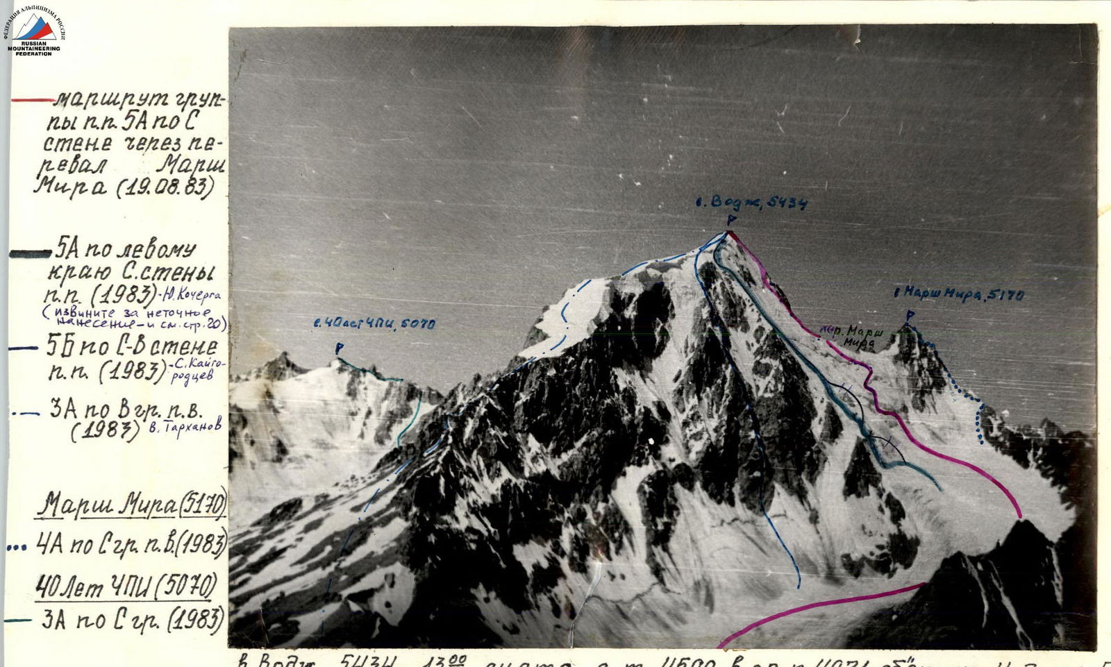
Mt. Vodzh, 5434, 13°, shot from point 4500 in gully 4971, lens Industar-50
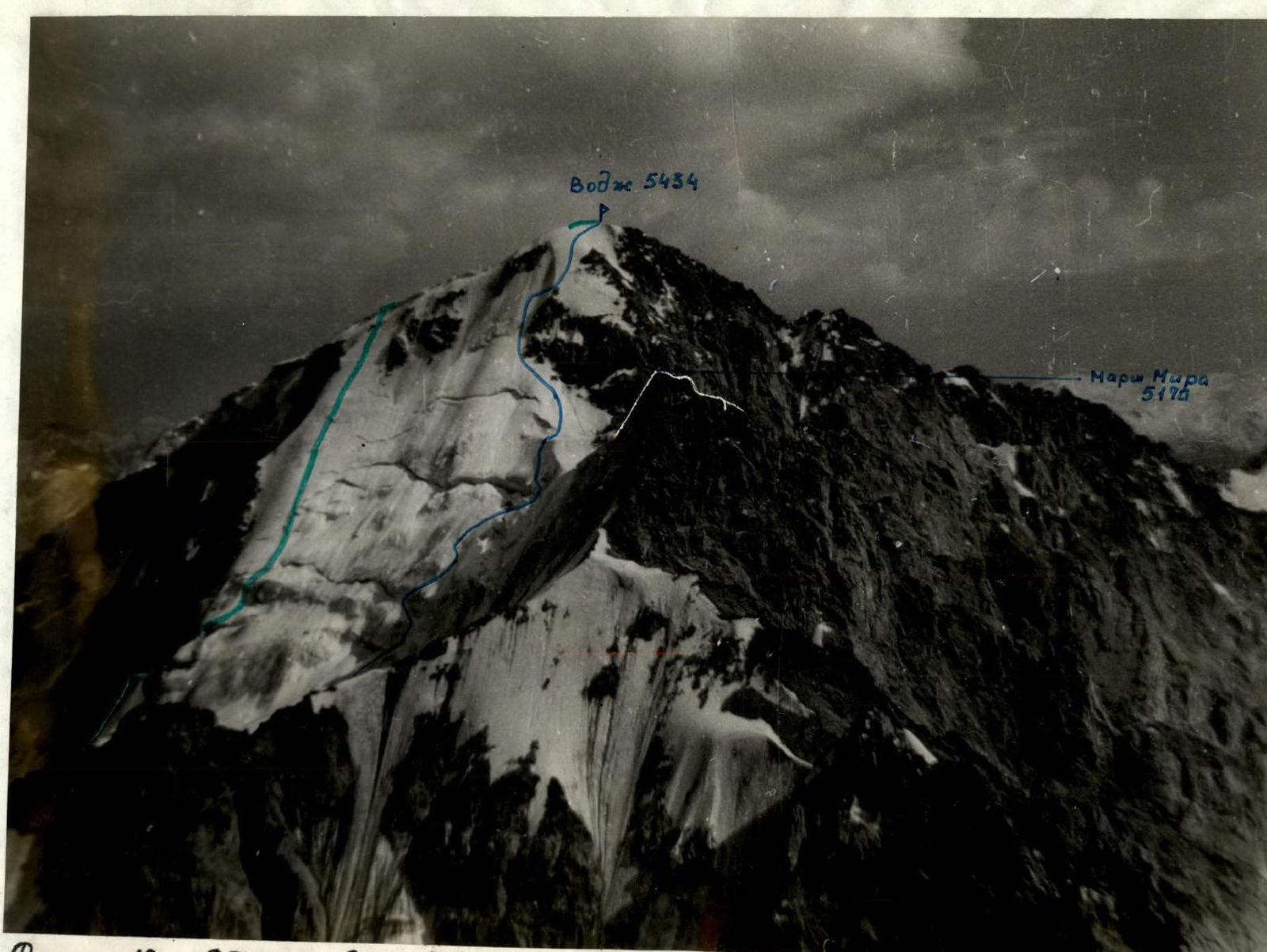
Photo #2. General view of Mt. Vodzh from NW from Gonda Rak ridge, August 23, 1985, 16:00, ~2.5–3 km 4600
— A. Fedyaev's route
— Yu. Kocherga's route
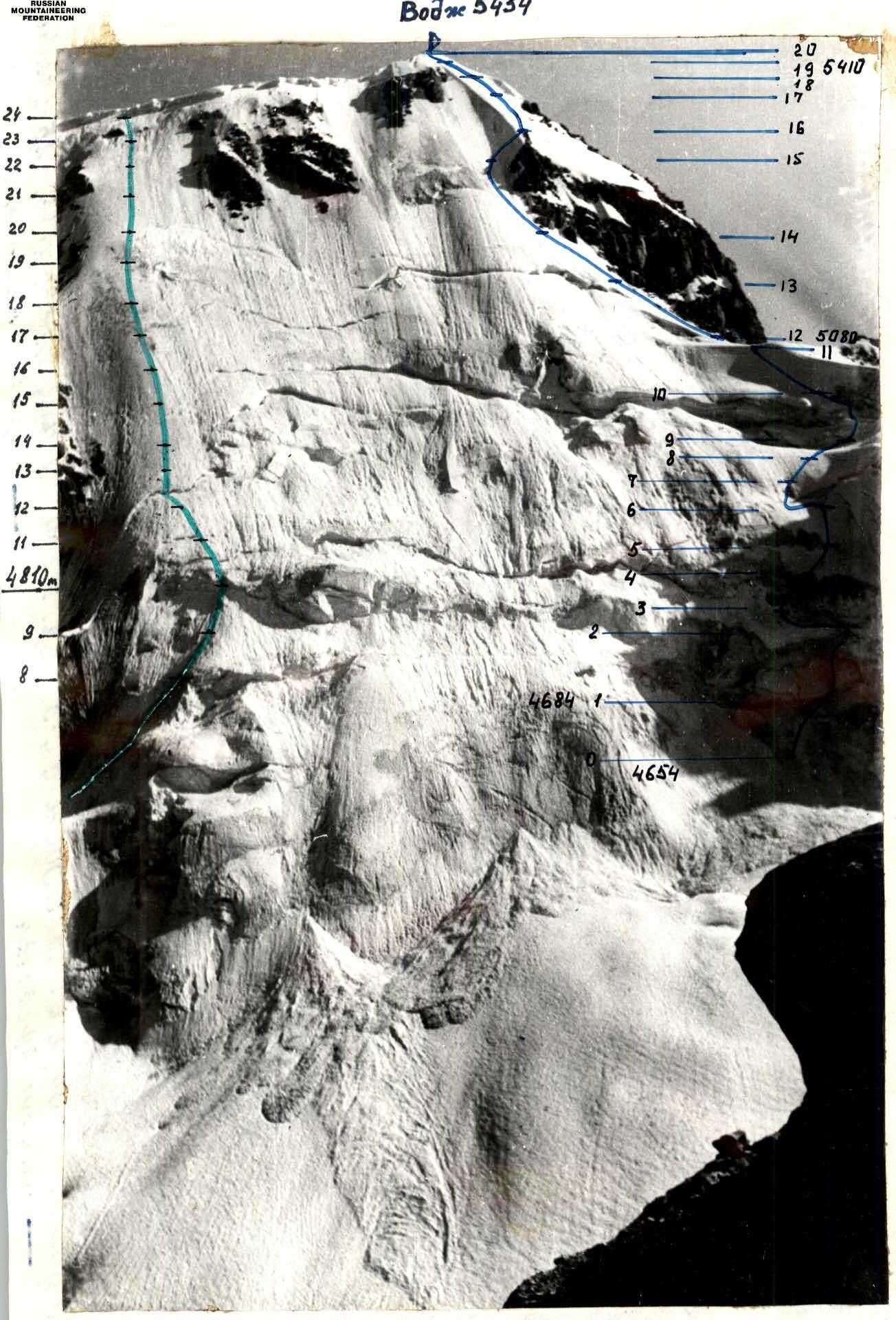
Photo #3. View of Mt. Vodzh from N. August 18, 1983, 16:30, "Helios-44-2"
— A. Fedyaev's route
~1.5 km 4500 m
— Yu. Kocherga's route
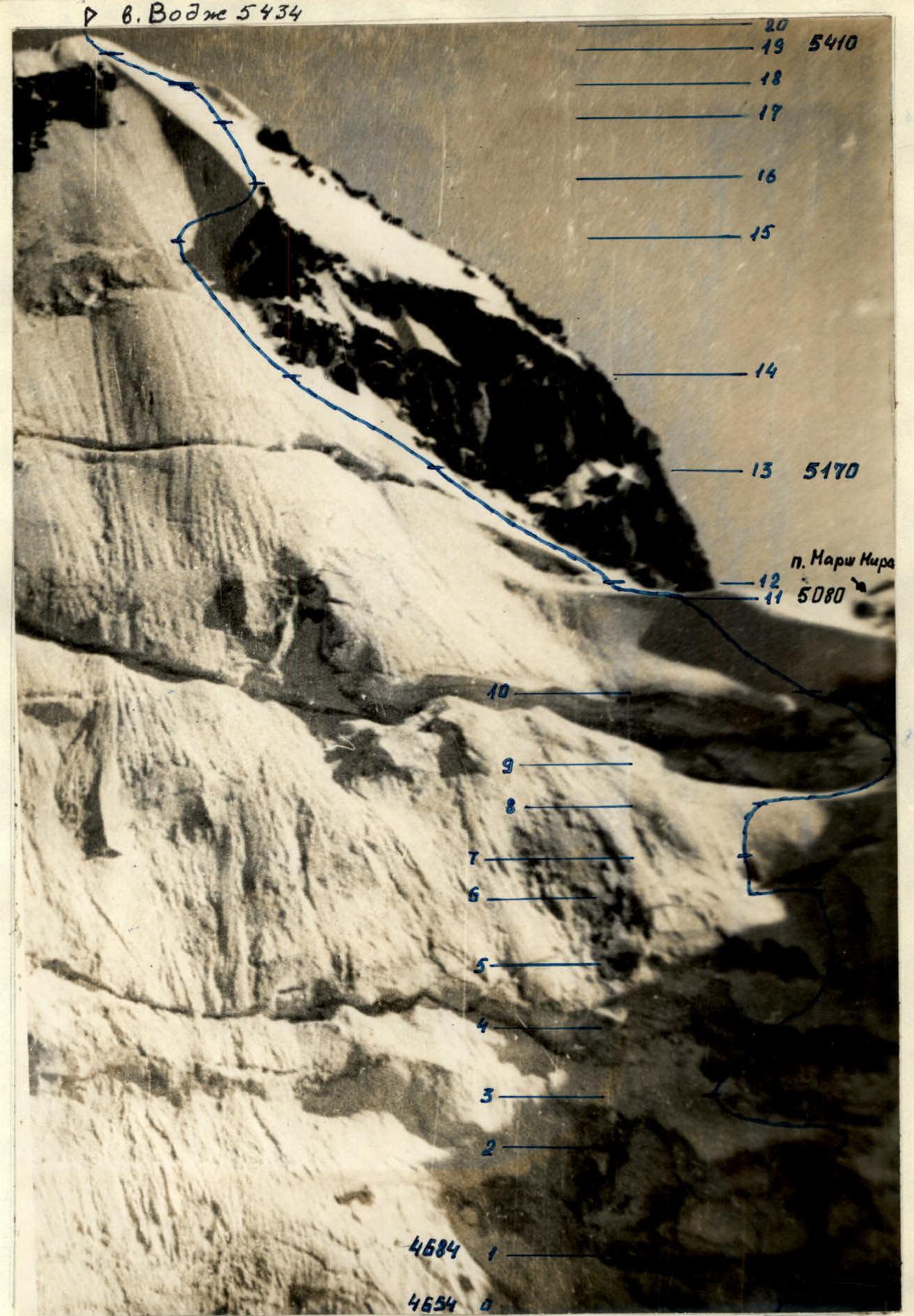
Photo #4. Technical photograph. August 18, 1983, 16:30
lens "Helios-44-2" (F=56 mm)
~1.5 km 4500 m
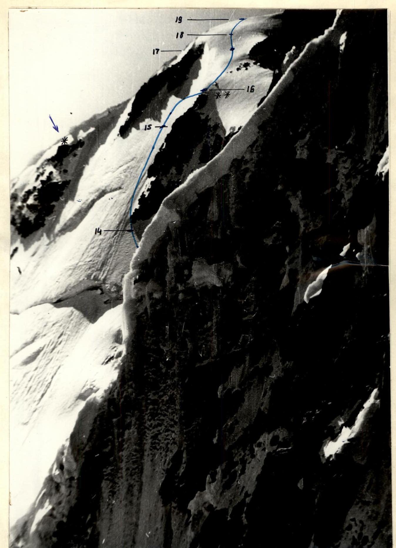
Photo #7. Upper part of the route from NW right profile August 22, 1983, 12:00, "Helios-44-2"
~1 km 4500 m
* — see photo #15.
** — see photo #16.
 www.alp-federation.ru↗
Mt. Vodzh (5434)
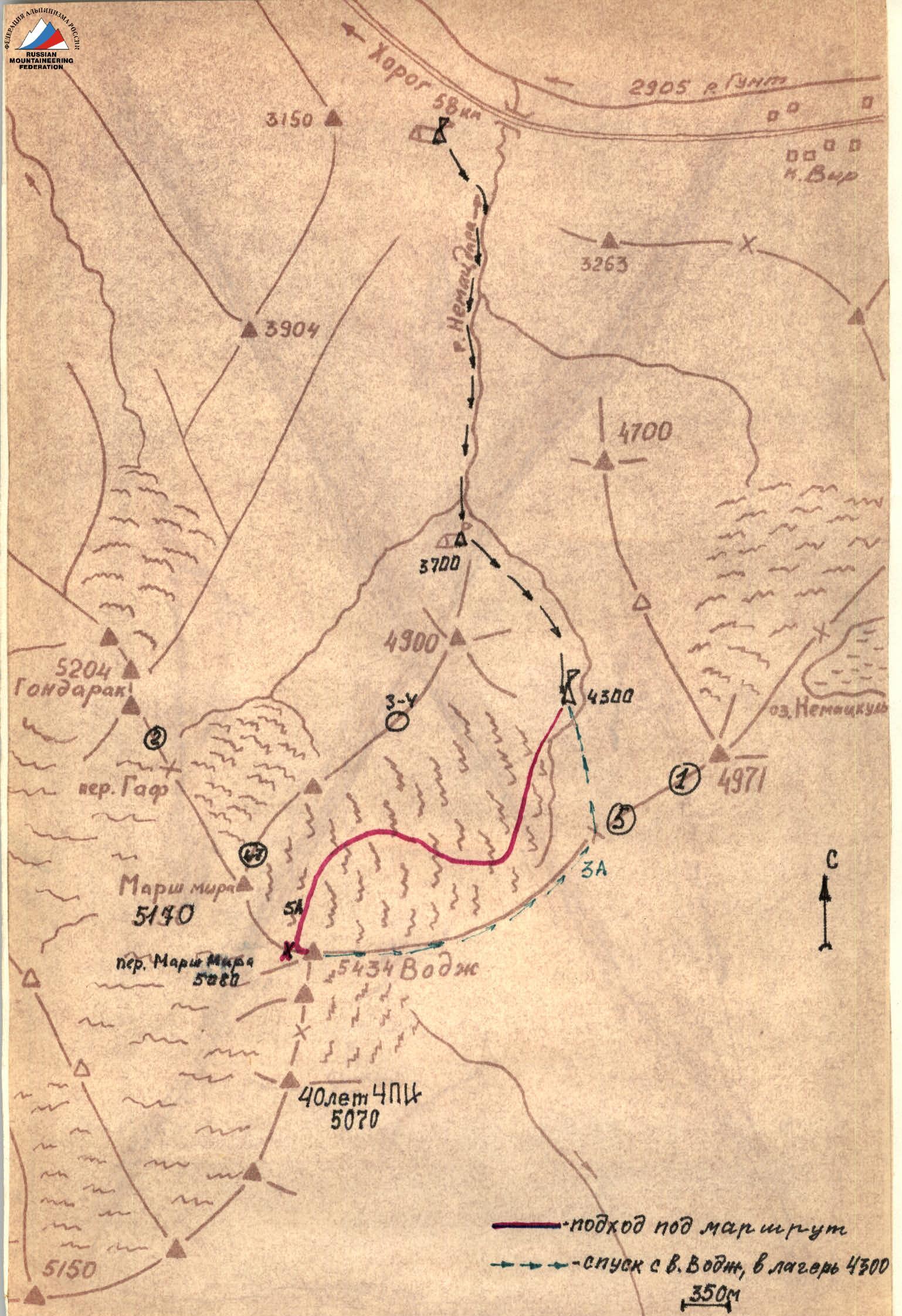
Approach Description
By car from Osh city along the Pamir highway, pass Vir settlement, and at 58 km, counting from Khorog city, on the left side along the way in a willow grove is the base camp. The assault camp is located on the right (orographically) side of the Vodzh-North glacier, under the pass between peak "4971" and peak Vodzh. The approach from the base camp to camp "4300" takes 4 hours. From camp "4300" the approach to the route takes 1.5 hours. From camp "4300" move along the right (orographically) side of the Vodzh-North glacier. In the central part of the glacier, cross to the left (orographically) side and exit to the plateau under Mt. Vodzh, where the route begins.
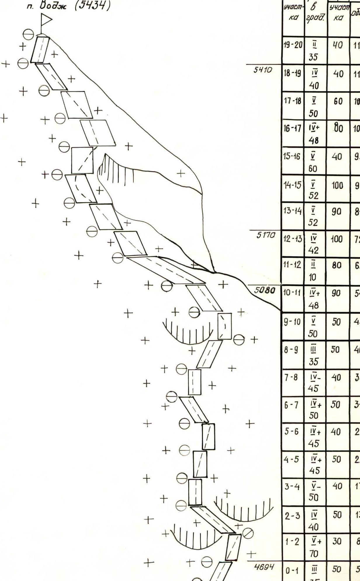
Form #12. Table of main characteristics of the ascent route to Mt. Vodzh via N face through Marsh Mira pass, 5A cat. diff., snow-ice Descent via 3A cat. ridge, 2 hours

| Date, time | Section designation | Average steepness, degrees | Length, m | Terrain character | Difficulty | Condition | Weather conditions | Rock pitons protection/ITO | Ice pitons protection/ITO | Bolt pitons protection/ITO |
|---|---|---|---|---|---|---|---|---|---|---|
| 19.08.1983 | ||||||||||
| 9:00–9:15 | R0–R1 | 35 | 50 | Firn slope | III | Hard firn | Good, cloudless | — / — | — / — | — / — |
| 10:05 | R1–R2 (4694) | 70 | 30 | Ice wall | IV+ | Accretion ice, in places overhangs, icicles | -"- | 2 / 0 | 6 / 0 | 2 / 0 |
| 10:30 | R2–R3 | 40 | 50 | Ice slope | IV | Ice covered with snow 5–10 cm | -"- | 4 / 0 | 6 / 0 | 0 / 0 |
| 11:15 | R3–R4 | 50 | 40 | Ice wall | V- | In places accretion ice | -"- | 5 / 0 | 0 / 0 | 0 / 0 |
| 11:35 | R4–R5 | 45 | 50 | Steep ice slope | IV+ | Accretion ice in places covered with thawed snow | -"- | 5 / 0 | 6 / 0 | 0 / 0 |
| 12:00 | R5–R6 | 45 | 40 | Ice slope | IV+ | Thawed porous snow, accretion ice | -"- | 5 / 0 | 0 / 0 | 0 / 0 |
| 12:30 | R6–R7 | 50 | 50 | Ice wall, transition through bergschrund | IV+ | Porous ice with cavities | -"- | 6 / 0 | 1 / 0 | 0 / 0 |
| 12:55 | R7–R8 | 45 | 40 | Steep ice slope | IV- | Porous ice in places firn | -"- | 5 / 0 | 0 / 0 | 0 / 0 |
| 13:10 | R8–R9 | 35 | 50 | Firn slope | III | Hard firn | -"- | 7 / 0 | 2 / 0 | 0 / 0 |
| 13:55 | R9–R10 | 50 | 50 | Ice wall, transition to "bergschrund" | V | Upon exiting to "bergschrund" accretion ice | -"- | 10 / 0 | 0 / 0 | 0 / 0 |
| 14:45 | R10–R11 | 48 | 90 | Steep ice slope, flattening before the saddle | IV+ | In places porous snow 5–7 cm | -"- | 12 / 0 | 1 / 0 | 0 / 0 |
| 15:15 | R11–R12 (5010) | — | 80 | Snow saddle | II | Loose snow | -"- | 8 / 0 | 0 / 0 | 0 / 0 |
| 15:55 | R12–R13 | 42 | 100 | Ice slope, gradually becoming steeper | IV | Ice covered with porous dry snow 7–10 cm | -"- | 12 / 0 | 1 / 0 | 0 / 0 |
| 16:45 | R13–R14 (5170) | 52 | 90 | Ice wall | V | Porous ice, in places thawed snow | -"- | 14 / 0 | 1 / 0 | 0 / 0 |
| 17:55 | R14–R15 | 52 | 100 | -"- | V | -"- | -"- | 14 / 0 | 1 / 0 | 0 / 0 |
| 18:45 | R15–R16 | 60 | 40 | Traverse of ice gully | V | Accretion ice | -"- | 12 / 0 | 1 / 0 | 0 / 0 |
| 19:40 | R16–R17 | 48 | 80 | Ice slope | IV+ | Accretion ice | -"- | 12 / 0 | 0 / 0 | 0 / 0 |
| 20:05 | R17–R18 | 50 | 60 | Ice wall | V | Hard ice | -"- | 6 / 0 | 2 / 0 | 0 / 0 |
| 20:25 | R18–R19 (5410) | 40 | 40 | Steep ice slope | IV | Ice covered with crust of thawed snow 5–10 cm | -"- | 2 / 0 | 0 / 0 | 0 / 0 |
| 20:40 | R19–R20 | 35 | 40 | Firn slope, exit to the summit | III | Hard firn, dry snow | -"- | 5 / 0 | 0 / 0 | 0 / 0 |
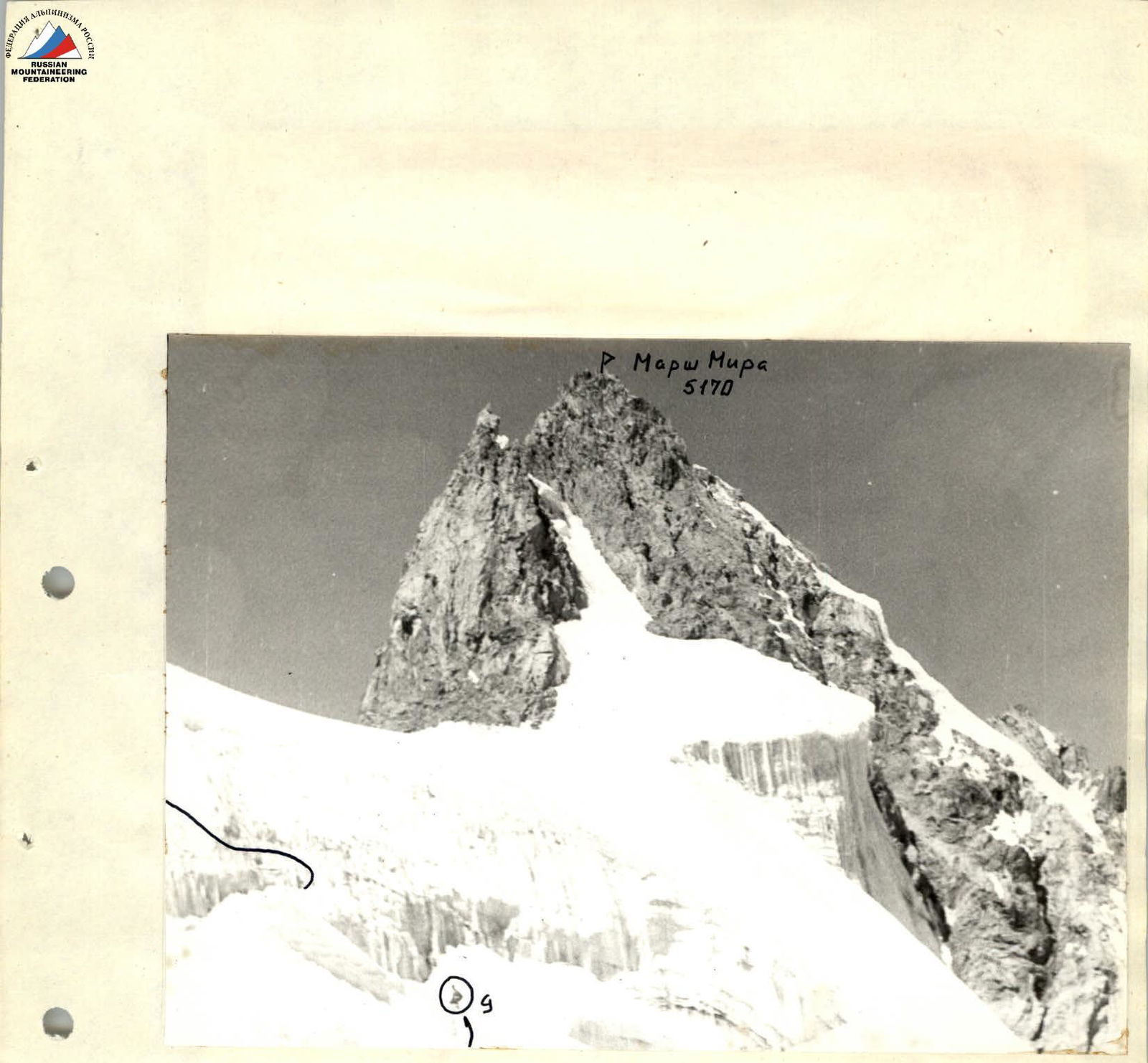
 Photo #12. Marsh Mira 5170
Photo #13. Section R13–R14