Moscow Regional Council of the Zenith Voluntary Sports Society
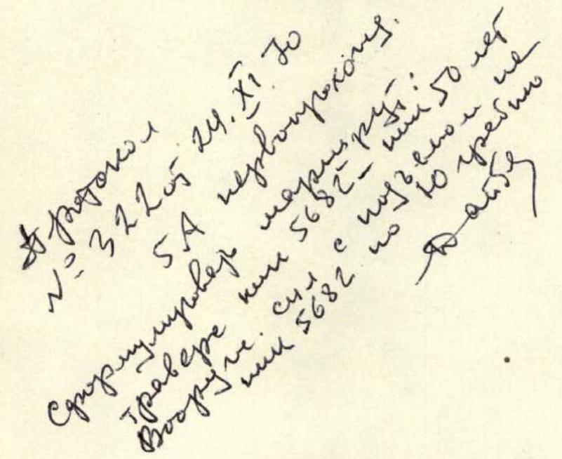
Traverse
- Peak 5600
- Peak 5682
- Peak 50 Years of the Armed Forces (Central Pamir)
Team Composition
- Pugachev V.A. — II sports category — team leader
- Kuzmin A.S. — I sports category — team member
- Makhnovich L.A. — II sports category — team member
- Vorobyov L.F. — II sports category — team member
- Balakin A.V. — II sports category — team member
Senior coach — P.I. Povarnin, Master of Sports of the USSR
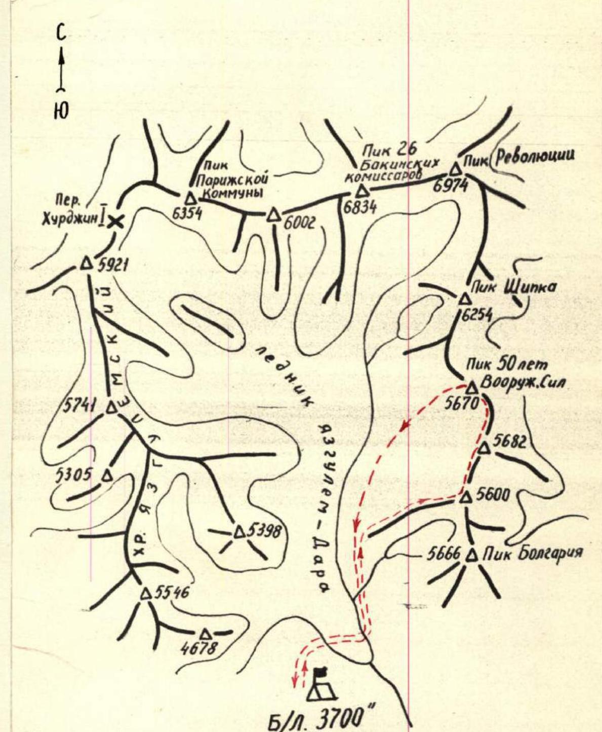
Map of the Area
Geographical Location
The gathering place for the Zenith Voluntary Sports Society (DSS "Zenith") climbers in 1970 was the area around Peak Revolyutsii in the Central Pamir, with the base camp located in the upper reaches of the Yazgulem-Dara valley.
The peaks — Peak 5600, Peak 5682, and Peak 50 Years of the Armed Forces (5670), which the team planned to traverse, belong to work on a mountain chain extending southward from the highest peak in the area, Peak Revolyutsii (6974).
On the opposite, western side of the valley, the peaks of the Yazgulem Range stretch from north to south, with most exceeding 5000 m in height.
The entire area is dominated by six-thousanders located in the northern part of the valley:
- Peak Revolyutsii,
- Peak 26 Baku Commissars,
- Peak Paris Commune,
from whose southern slopes originates the Yazgulem-Dara glacier, and from the northern slopes, one of the world's largest glaciers, the Fedchenko Glacier.
Climbing Conditions
The remoteness (over 100 km) from major settlements and roads significantly complicates the organization of expeditions to this area.
Only in 1967 did the first mountaineering expedition of the ЦСКА (Central Sports Club of the Army) athletes arrive here, with the goal of studying the area and identifying the most interesting routes for ascents for the USSR championship.
The expedition gathered a wealth of interesting data — photographs, aerial photographs; accomplished first ascents of Peak Shipka via the western ridge, Peak Bulgaria, and others. The significant altitude difference, up to 3 km or more, the steepness of the slopes, and the possibility of choosing unexplored complex ridge and wall routes on such peaks as Peak Revolyutsii, Peak 26 Baku Commissars, and others — all this promised great prospects for climbers.
Climatic conditions in this area are relatively favorable. In the summer months — July and August — fairly stable, clear weather is observed. However, at an altitude of around 6000 m, the wind almost never subsides, reaching 10–15 m/s, and temperatures drop to −20 °C at night.
The army athletes' expedition marked the beginning of the development of this high-altitude area by climbers. In the following two years — 1968–1969 — routes of the highest category of difficulty were first laid:
- on Peak Revolyutsii via its southwest wall,
- on Peak 26 Baku Commissars from the south,
- the traverse Peak Revolyutsii — Peak 26 Baku Commissars was completed.
These ascents were awarded prize places in the USSR mountaineering championship.
Pre-Climb Preparation
The Zenith DSS "Zenith" mountaineering team, along with the combined team of the Central Council of the Zenith DSS, arrived in the district center Rushan on July 4. The delivery of cargo and personnel to the base camp location was carried out from the Rushan airfield by helicopter, which eliminated the need to organize a slow and cumbersome caravan. By July 7, all work on organizing the base camp on a large, flat green area near the tongue of the Yazgulem-Dara glacier at an altitude of 3700 m was completed.
Reconnaissance and training ascents were planned to study a larger area and choose the most interesting routes for ascents.
Additionally, training ascents provided an opportunity for athletes to acclimatize at high altitudes.
On July 9, the entire expedition made a reconnaissance sortie to study the path through the glacier and approaches to peaks in the area of:
- Peak Paris Commune,
- Peak Revolyutsii,
- Peak Shipka.
Two days later, a group of 5 people, including team members Kuzmin and Makhnovich, embarked on an ascent of Peak 4678. Besides training purposes, the group was tasked with:
- Conducting preliminary reconnaissance of the area around Peak Lyap-Nazar (5988) — one of the notable peaks in this valley.
Simultaneously, another group of 6 people, including team members Pugachev and Vorobyov, ascended a rocky massif ("Grebёнka") on the ridge of Peak 5600 on the opposite side of the valley from the camp. From here, from Grebёнka (5100 m), they surveyed the further path to Peak 5600, located between Peak 5682 and Peak Bulgaria, as well as the unexplored southwest ridge of Peak Shipka.
On July 14, a group of 4 people ascended Peak Bulgaria (5666) via Peak 5600. The next day, July 15, a second group of 6 people followed the same route. Team members Vorobyov, Pugachev, Kuzmin, and Makhnovich were part of these groups. The ascent lasted 5 days. From Peak 5600, they surveyed the saddle leading to the base of the wall of Peak 5682 — a peak characterized by its sharp outlines and yet unconquered by climbers.
From July 22–24, Pugachev (team leader), Kuzmin, and Vorobyov, as part of a group of 4, accomplished a first ascent of Peak 5398 m in a spur of the Yazgulem Range, while another group of 4, with Makhnovich (team leader) and Balakin, was the first to ascend Peak 4816 m, conducting reconnaissance of the path to Peak Lyap-Nazar.
Based on the results of the ascents and reconnaissance sorties, the objects for the ascent in the Zenith DSS Central Council championship and the Moscow city championship were finalized.
For the high-altitude technical ascent category, the route to Peak Shipka (6254 m) via the southwest ridge was chosen. For the traverse category, it was decided to follow the route developed by the team:
- Peak 5600
- Peak 5682
- Peak 50 Years of the Armed Forces
This traverse route was sufficiently well-studied during previous ascents.
The traverse was planned to be carried out after the ascent of Peak Shipka, which was accomplished from July 28–31 by a group including Kuzmin (team leader), Makhnovich, Vorobyov, Pugachev, and Ivanov (coach).
During the same period, another group of 4, led by Balakin, ascended Peak 50 Years of the Armed Forces.
The following team composition was approved for the traverse:
- Pugachev V.A. — II sports category, team leader
- Kuzmin A.S. — I sports category, team member
- Makhnovich L.A. — II sports category, team member
- Vorobyov L.F. — II sports category, team member
- Balakin A.V. — II sports category, team member
Based on the reconnaissance results of the route during previous ascents, organizational and tactical plans for the ascent were developed.
Ascent Organization
Considering the route's characteristics — the presence of snow-ice sections as well as rocky ridge and wall sections — in addition to standard equipment, the team selected:
- titanium rock pitons (30 pcs.);
- ice pitons (6 tubular and 10 screw);
- three-step ladders (4 pcs.);
- titanium crampons (2 pairs);
- drill (3 pcs.);
- drill pitons (15 pcs.).
The group was equipped with one high-altitude tent that had proven itself in adverse weather conditions and strong winds. The amount of food was calculated based on 750 g of dry rations per person per day for 5 days on the route. For communication with the base camp, a portable radio set was taken, and communication sessions were scheduled for 9:00 and 19:00; emergency communication times were set for 12:00 and 21:00. The deadline for returning to the camp was set for August 15 at 18:00. The ascent was monitored directly from the camp. The entire route was divided into main sections, and bivouac locations were identified. It was assumed that the wall of Peak 5682 would be the key section of the route.
Route Progression
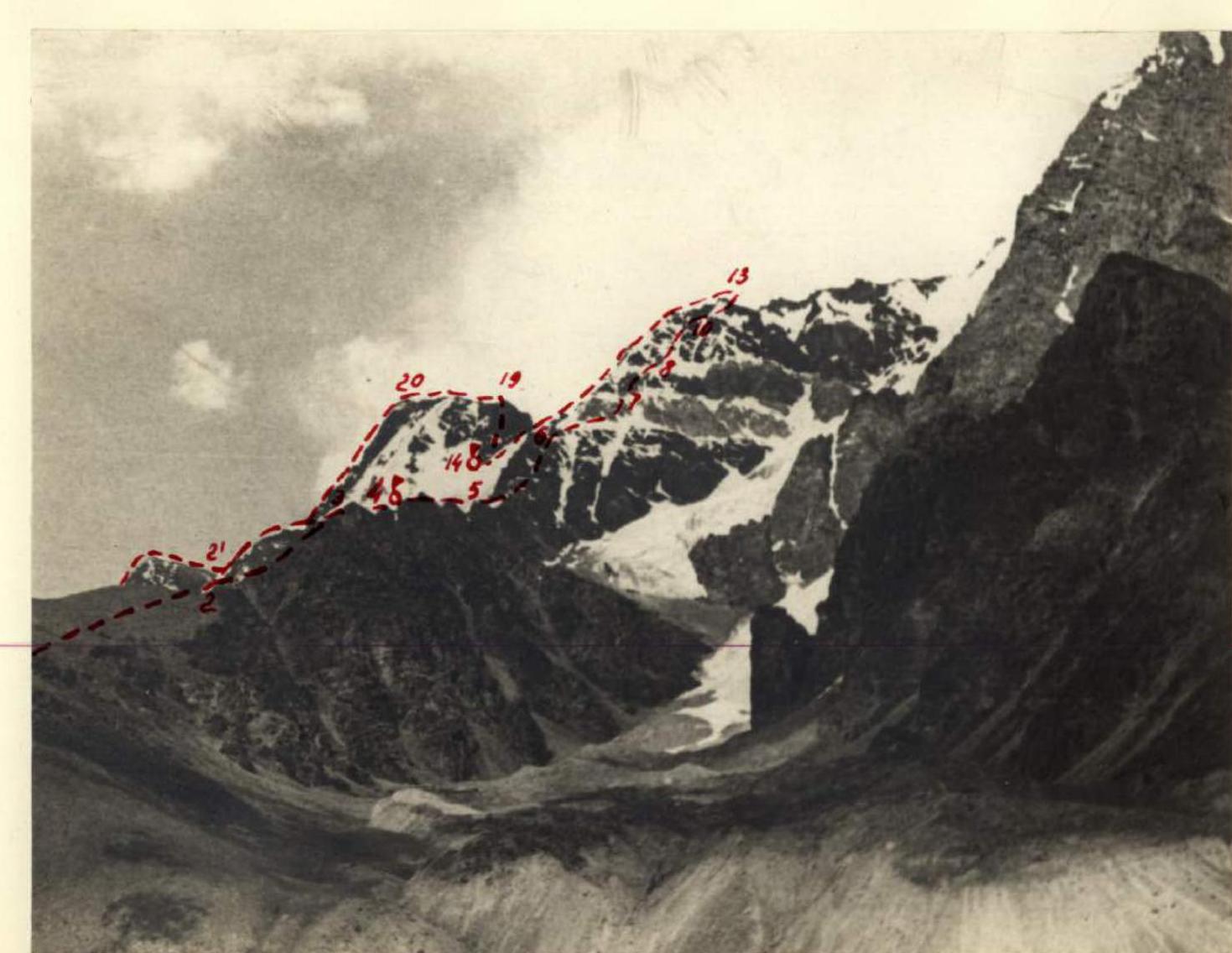
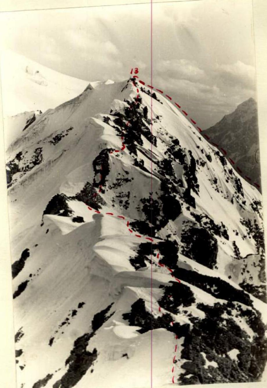
Day 1. On August 9 at 2:00, the group departed from the "3700" base camp, crossed the Yazgulem-Dara glacier in its lower part, ascended to the left-bank moraine, and continued upwards, initially along a grassy slope and then along medium and large scree towards the rocks on the western ridge of Peak 5600. After a short rest on a wide, flat area covered with large stone slabs, the two ropes — Kuzmin-Makhnovich and Vorobyov-Balakin-Pugachev — proceeded to the heavily weathered rocks. The upper part of the rocks is a series of rocky outcrops — "Grebёнka". They moved simultaneously, placing ropes through ledges and trying not to dislodge stones. At the top, the rocks are less weathered and steeper. They entered a saddle between the 1st and 2nd outcrops. The second outcrop was traversed via ledges on the right with alternating protection through ledges. They found a small platform before the next rocky ascent and settled in for the night at 17:00. Nearby, on a small rocky shoulder, they built a control cairn.
Day 2. On August 10 at 7:00, they continued on the route. They progressed with alternating protection through outcrops along rocks of medium difficulty, bypassing "genuine" obstacles mainly on the right via ledges or climbing (R4–R5). The last "genuine" obstacle was overcome with piton protection (2 pitons). After passing a small snow couloir, they reached a black rocky wall representing the ascent of the ridge, 120 m long with an average steepness of 60° (R5–R6). Via snow and rock ledges (1 piton), they reached a chimney (60°, 60 m) covered with rimed ice with stones frozen into it (2 pitons) (R6–R7). The chimney led to a wall (50°, 60 m, 2 pitons) (R7–R8). Then, along a small snowfield, they approached a steep (80°), almost smooth slab, which they traversed with complex climbing on the right (1 piton) (R8–R9). The final ascent of the wall (60°, 100 m) was made "head-on" (R9–R10). They emerged onto a snow-ice couloir (R10–R11). Its upper slope was steep. They moved with alternating protection through an ice axe. The couloir led them to a snow ridge (160 m) (R11–R12), so sharp that both feet couldn't fit, requiring careful treading by the leader. In the middle part, the ridge turned into a thin, overhanging cornice, which they carefully bypassed on the right, descending 2–3 meters along a steep (60°) snow slope. Movement was alternating with protection through an ice axe. The ridge led to the summit rocks 8–10 m high (1 piton) (R12–R13). At 15:00, the group reached the summit of Peak 5600. They found a note from a Zenith DSS "Zenith" group dated July 16 of the same year, heading to Peak Bulgaria. Strong winds made it difficult to stay; they left their own note and began descending to the saddle leading to the wall of Peak 5682 (R13–R14).
The saddle had several rocky and snowy ascents. The maximum height difference from Peak 5600 to the saddle was 250–300 m. Under a thin layer of snow lay ice. Ice cracks, covered with snow, were encountered. To the right, there were cornices. Rocks were of medium difficulty.
They organized three consecutive rappels using pitons (4 rock and 1 ice).
They tried to move along the boundary between rocks and snow, avoiding cornices. In some places, ice was exposed, requiring step-cutting.
Rocky sections were overcome using pitons (3 pitons) and ledges for protection.
The wind strengthened. Hands froze. They frequently warmed their hands in down gloves.
Finally, the last rocky ascent led them to a couloir before the wall of Peak 5682.
The wall appeared very imposing up close — a sheer monolithic rock. In the middle, there was a chimney closed at the top by rock plugs. It was impossible to bypass it. To the left, there was a steep (60°) rocky slope covered with snow and ice, with falling rocks (dangerous); to the right, the couloir descended, and the wall grew larger, becoming even more inaccessible. The route was clear: reach the chimney and exit onto a small platform, from which the further path to the upper part of the wall could be surveyed. At 17:30, Kuzmin and Vorobyov proceeded to process the wall while the others prepared a platform for the tent. Kuzmin reached the chimney. The chimney's walls were sheer with no holds. In the lower part, there were no cracks to place a piton. They had to climb onto each other's shoulders. Finally, Kuzmin managed to reach the first narrow crack, placed a petal piton, and hung the first ladder. They avoided using a drill. After ascending 80 m and placing two ropes (16 pitons), Kuzmin and Vorobyov descended. Processing this part of the wall took about 4 hours. A strong gusty wind blew throughout the night, shaking the tent. Fatigue from a day of continuous work was evident, and they fell asleep in their down sleeping bags under the howling wind.
Day 3. On August 11 at 9:00, they resumed their ascent. The lower section of the wall (80°, 40 m) (R14–R15) was traversed with complex climbing and piton protection (5 pitons) to a ledge under the chimney. On a round niche to the right of the chimney, they built a control cairn and left a note. The chimney, 15–20 m high, was closed at the top by rock plugs with a narrow slit between them (R15–R16). To the second plug (10 m), they climbed using ladders hung the previous day (5 pitons). They squeezed through the narrow slit between the plugs. The chimney turned into a wall (70°, 40 m). Very complex climbing was required, with a piton every 5 meters (R16–R17). The weather seemed to be holding, but during the work in the upper part of the wall, they were unexpectedly enveloped in dense fog. Strong, unrelenting wind couldn't disperse it. Visibility was 40–50 meters. Snow began to fall, driven by the wind, and settled on the rocks. Occasionally, the fog momentarily cleared, only to close in again. Hoping for an improvement in weather was futile, so they decided to find a place to bivouac. Along a rocky-ice couloir (60°, 60 m) (R17–R18), they climbed onto a rocky rib. Here, at 14:30, they discovered a gap in the ridge — a "stone bag" — with an inclined base. Within 2 hours, they leveled the area and set up the tent. The site was reliably protected from the wind. The day's achievement: they overcame the 150-meter wall — the key section of the route. The camp radioed that the wind speed at 20 m/s and predicted worsening weather for the next day, but this forecast did not materialize.
Day 4. By the morning of August 12, the weather had significantly improved, and at 7:00, they continued their ascent. The final section before the summit ridge (60 m) was traversed via a couloir (45°) (R18–R19) covered with rimed ice under a thin layer of snow (1 tubular ice piton). Then, they moved along the summit ridge (R19–R20) with an average steepness of 15°. They progressed along the boundary between rocks and snow, carefully crossing cracks and avoiding large cornices hanging over the eastern slopes of Peak 5682. Three snow-ice couloirs with a height difference of 20 m each were traversed in crampons with step-cutting and piton protection (3 ice pitons). The final snowy ascent led them to the summit at 9:00. No one had been here before. They built a cairn and left a note, suggesting the name "Peak SOYUZ" for the peak. The view was magnificent, with Peak Lyap-Nazar in front, followed by unnamed peaks they dubbed "Sugar Head" and "Tent". After enjoying the panorama, they began descending along the ridge to the saddle between Peak 5682 and Peak 50 Years of the Armed Forces (R20–R21). The height difference between Peak 5682 and the saddle was 200–250 meters. The eastern side of the ridge presented a series of snow-ice couloirs with height differences up to 40 m, ending in overhanging snow cornices and alternating with sharp ridge rocks. The average steepness was about 40°. They moved mainly on snow, near rocks, with protection through an ice axe. Steep slopes with exposed ice were traversed using sports climbing techniques (3 rock pitons and 1 ice piton). At 12:00, they reached the saddle before Peak 50 Years of the Armed Forces. After a short rest, they began ascending from the saddle along the southern snow-ice slope of Peak 50 Years of the Armed Forces (R21–R22). The steepness was 40°. Rocky scree was encountered in places. They moved simultaneously until they reached the pre-summit rocky outcrops. A short rocky section was also traversed simultaneously, placing ropes through ledges.
Day 5. At 13:30, they approached the cairn on the summit. They retrieved a note from climbers of the Zenith DSS "Zenith" who had ascended this peak on July 29, 1970, from the saddle between Peak Shipka and Peak 50 Years of the Armed Forces, and left their own note. This was the final peak of the traverse. They descended along steep, unstable rocks (R22–R23) with piton protection and through ledges on a route rated by previous climbers as category III technical difficulty. On steep, virtually sheer rocky sections and at the bottom on a snow-ice slope with a steepness of over 50°, they organized four sports descents, two rappels. At 17:00, they reached the saddle. Further descent along the snowy couloir was not very complicated but was avalanche-prone at this time of day. Here, on the saddle, they made their final overnight stay. On August 13 at 7:00, they began descending the couloir, protecting themselves with an ice axe. Twice during the descent, they used tubular ice pitons. At 8:00, they completed the descent (R23–R24) and returned to the "3700" base camp.
Overall Assessment of the Team's Actions
All team members were physically well-prepared. Their actions on the route were characterized by high reliability, tactical and technical maturity, and the ability to use the entire arsenal of mountaineering techniques, especially evident on the most challenging section — the 150-meter wall of Peak 5682. The cohesive team composition allowed for an even and rational distribution of forces among participants on the route.
Both ropes alternated in leading, maintaining a good pace on the route. The successful first traverse was also facilitated by the team's inherent sense of collectivism and camaraderie.
Conclusion
The traverse represents a combined rock-snow-ice route, passing at altitudes between 4800 and 5682 m. Its length is 4.1 km. The total ascent is 2500 m, with the most challenging sections being 400 m. The route corresponds to category 5B complexity.
Team leader: Pugachev V.A. Team members:
- Kuzmin A.S.
- Makhnovich L.A.
- Vorobyov L.F.
- Balakin A.V.

Peak 5600 — Peak 5682
Peak 5600 (descent to the saddle towards the wall of Peak 5682)
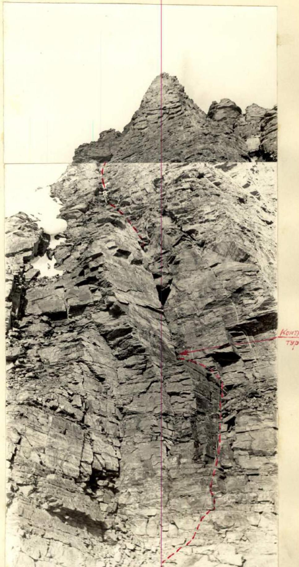
Wall of Peak 5682
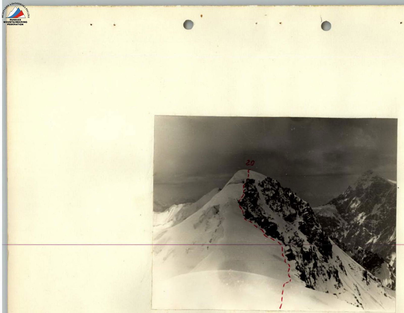
Peak 5682 (from the saddle before Peak 50 Years of the Armed Forces)

Ascent Route
Traverse of Peaks: Peak 5600 — Peak 5682 — Peak 50 Years of the Armed Forces
Height difference on the route: 2470 m, including the most challenging sections: 400 m.
Steepness of the route: 0° + 90°, including the most challenging sections: 60° + 90°
| Date | Sections Covered | Avg. Steepness of Section/deg | Section Length (m) | Terrain Character | Technical Difficulty | Method of Overcoming and Protection | Weather Conditions | Departure Time | Bivouac Time | Walking Hours (h) | Pitons Driven: Rock (pcs) | Pitons Driven: Ice (pcs) | Pitons Driven: Drill (pcs) | Bivouac Conditions | Daily Ration Weight (g) |
|---|---|---|---|---|---|---|---|---|---|---|---|---|---|---|---|
| August 9 | R0–R1 | 0° | 3000 | from camp, left-bank moraine, glacier | simple | simultaneous, no protection | clear | 11:00 | |||||||
| R1–R2 | 30° | 1500 | moraine, grassy slope | -"- | -"- | -"- | 6:00 | 600 | |||||||
| R2–R3 | 50° | 200 | heavily weathered rocks | simple | free climbing with simultaneous protection | -"- | 17:00 | platform on rocky ridge | |||||||
| R3–R4 | 20° | 80 | unstable rocks, average slope steepness 50° | simple | traverse with alternating protection through ledges | -"- | |||||||||
| August 10 | R4–R5 | 20° | 250 | unstable rocky outcrops («grebёнka») «slope steepness 50°» | medium difficulty | traverse with alternating protection through pitons and ledges | -"- | 7:00 | |||||||
| R5–R6 | 60° | 120 | rocky wall — ridge ascent | complex | alternating climbing, protection through pitons and ledges | -"- | 4:00 | ||||||||
| R6–R7 | 60° | 60 | chimney with rimed ice | complex | climbing | -"- | 3:00 | ||||||||
| R7–R8 | 50° | 60 | rocky wall — ascent | complex climbing | -"- | -"- | 2 | ||||||||
| R8–R9 | 30° | 20 | rocky slab, steepness, inclination 80° | complex climbing, traverse | -"- | -"- | 1 | ||||||||
| R9–R10 | 60° | 100 | rocky wall — ridge ascent | complex climbing | -"- | -"- | 2 | ||||||||
| R10–R11 | 50° | 60 | snow-ice couloir with steep ascent | medium difficulty | alternating, protection through ice axe and piton | clear, windy | 1 | ||||||||
| R11–R12 | 15° | 160 | sharp (60°) snow ridge, mid-section cornice | medium difficulty, increased danger | alternating, protection through ice axe | light cloud cover, windy | |||||||||
| R12–R13 | 60° | 10 | unstable summit rocks | medium difficulty | alternating, protection through piton | cloudy, strong wind | 8:00 | 1 | |||||||
| R13–R14 | -40° | 500 | saddle, descent along ridge with rocky and snow-ice ascents, cornices, cracks | medium difficulty | alternating, protection through ledges, pitons, and ice axe, step-cutting, 3 sports descents | cloudy, very strong wind | 17:30 | 2:30 | 4 | 1 | snow couloir before Peak 5682 wall | 600 | |||
| August 11 | R14–R15 | 80° | 40 | monolithic wall, firm rocks, few holds | complex climbing | alternating, piton protection | cloudy, light wind | 9:00 | 5:00 | ||||||
| R15–R16 | 90° | 20 | chimney with plugs, no holds | very complex climbing | ladders, alternating, piton protection | -"- | |||||||||
| R16–R17 | 70° | 40 | wall, rocks with sections of rimed ice | very complex climbing | alternating, piton protection | fog, visibility 40–50 m, snowfall, strong wind | 8:00 | 8 | |||||||
| R17–R18 | 60° | 60 | rocky couloir with snow and rimed ice | complex climbing | alternating, protection through pitons and ledges | -"- | 14:30 | 5:30 (without 2:00 for preliminary wall processing (4:00)) | platform in rocky ridge | 600 | |||||
| August 12 | R18–R19 | 45° | 60 | couloir with rimed ice and rocky sections | medium difficulty | -"- | variable cloud cover | 7:00 | 1 | ||||||
| R19–R20 | 15° | 320 | summit ridge, cornices, and snow-ice couloirs leading to the summit | simple, some medium difficulty | crampons, alternating, protection through pitons and ice axe | -"- | 2:00 | ||||||||
| R20–R21 | -40° | 400 | ridge with rocky and snow-ice ascents, cornices, cracks | medium difficulty | alternating, protection through pitons, ledges, and ice axe | -"- | 3:00 | 3 | 1 | ||||||
| August 13 | R21–R22 | 40° | 300 | snow-ice slope and rocky scree | simple section | simultaneous, protection | -"- | 1:30 | |||||||
| R22–R23 | -60° | 300 | unstable rocks, lower part snow-ice slope | medium difficulty | alternating, protection through pitons, ledges | -"- | 3:30 | 4 | 1 | snowy couloir | 600 | ||||
| R23–R24 | -45° | 1000 | snowy couloir, some ice | medium difficulty | alternating, protection through piton and ice axe | -"- | 7:00 | 1:00 | 2 | ||||||
| R24–R25 | -10° | 6000 | moraine, further along the approach path | without protection | -"- | 3:00 | |||||||||
| Total: | 40:00 | 49 | 10 |