
SPARTAK SPORTS SOCIETY CENTRAL COUNCIL CHAMPIONSHIP IN ALPINISM 1984 TECHNICAL CLIMB CLASS
Report
ON THE FIRST ASCENT TO THE SUMMIT 5156 m VIA THE CENTER OF THE EAST FACE BY THE LGS SPARTAK TEAM
Team Leader — ISAchenko G.I. Team Coach — ISAchenko G.I.
Participants:
- A. Malinovsky
- A. Nardov
- V. Podgursky
Contact Information:
- Phone: 8-10/III-84
- Address: Leningrad, Vyazovaya Alley, 8
Additional Data:
- 630, 740, γ-V/I 64° γI, /30 k, 2 zap./
- 25 hours
- 3 days
Organization: LGS Spartak Sports Society Responsible Person: NOVGORODTSEVA GALINA PETROVNA
Team Leader and Coach: ISACHENKO GENNADIY IVANOVICH
Contact Information:
- Address: Leningrad, Krasnoy Svyazi St., 9, apt. 4
- Phone: 272-39-65
The heights mentioned in the report were determined:
- from the map — summit, base camp;
- using an altimeter — start of the route, height of the summit cirque;
- other heights — visually.
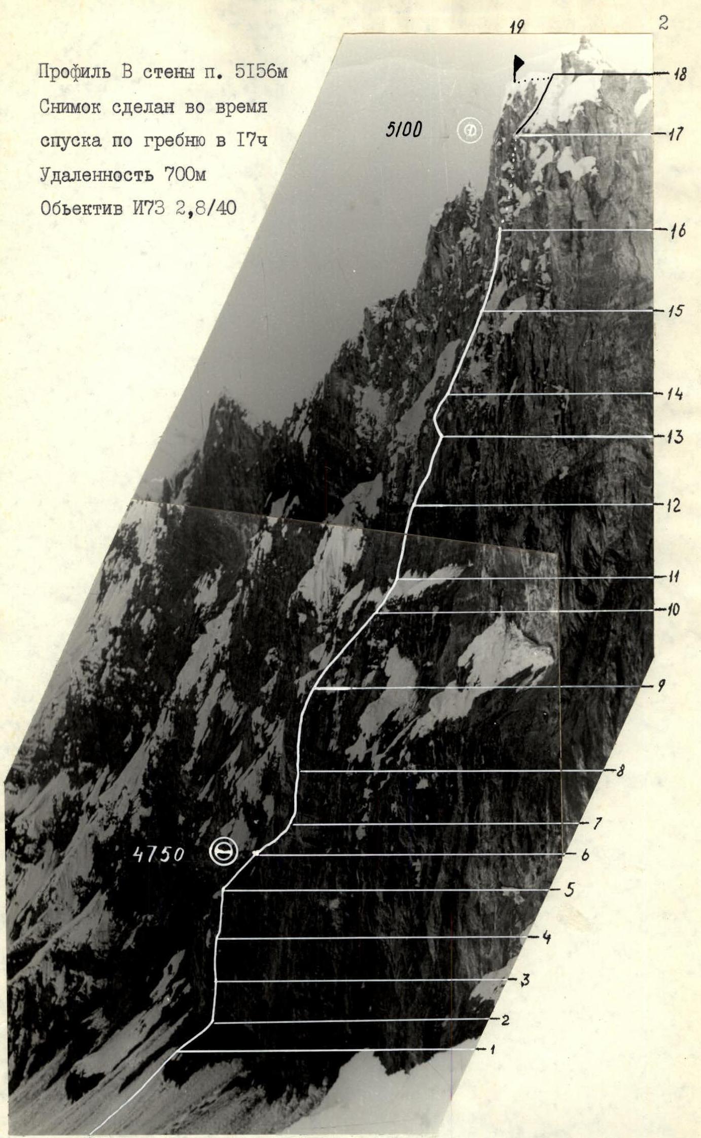
Profile of the East face of peak 5156 m. Photo taken during the descent along the ridge at 17:00.
Distance 700 m. Lens I73 2.8/40
 M 1:100000
Brief Overview of the Climbing Area
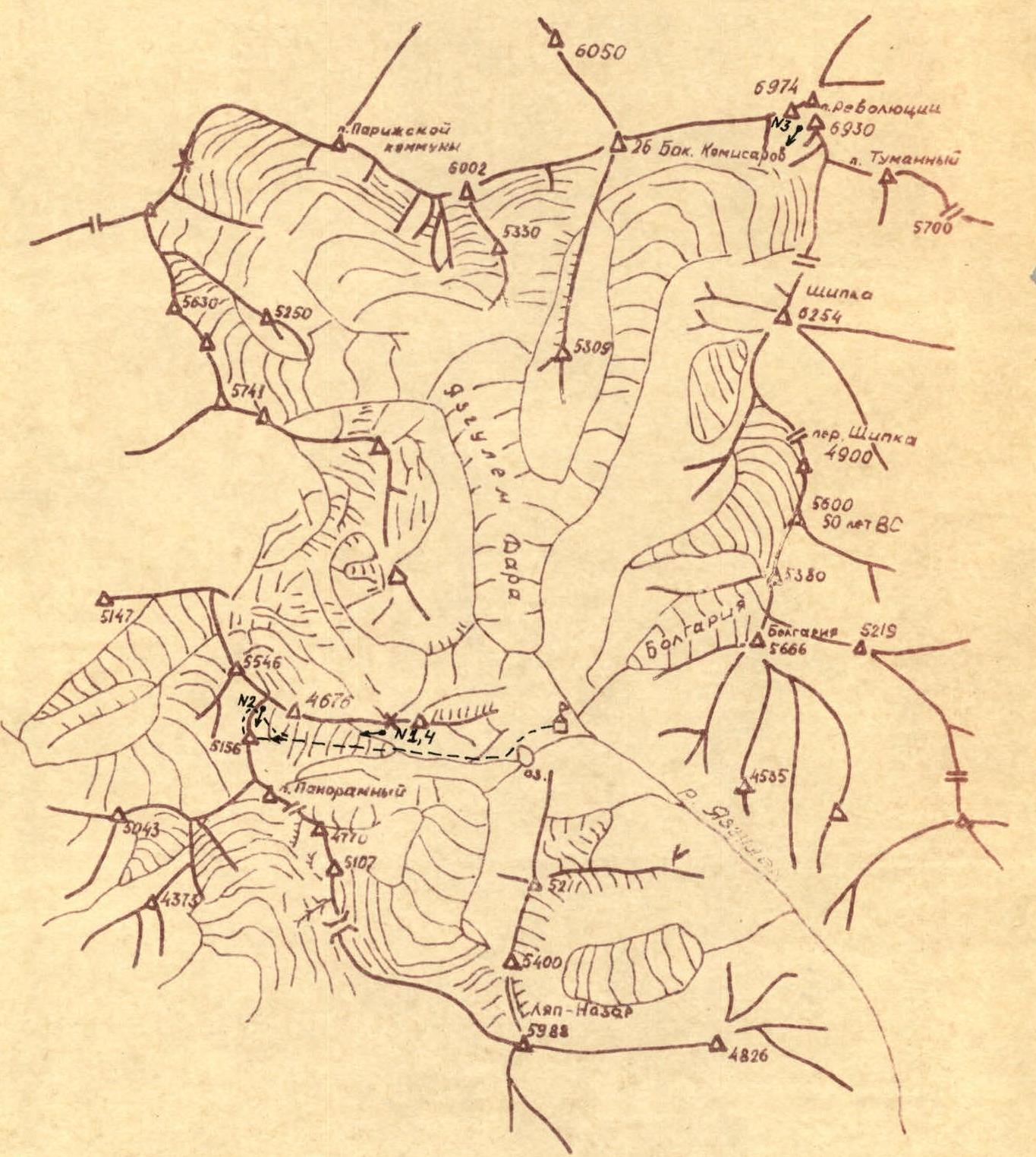
The object of the ascent, peak 5156, is located in the spurs of the Yazglem Ridge to the southwest of Peak Revolyutsii, in a cirque formed by the northwest and north ridges of Lyap-Nazar Peak.
The stream formed by the melting glacier of this cirque flows into the Yazglem River, slightly below the tongue of the Yazglem-Dara glacier, which descends from the southern slopes of Peak Revolyutsii and 26 Baku Commissars. At the confluence of the stream and the Yazglem River, there is a large clearing — a traditional and most convenient location for a base camp and helicopter landing for all expeditions to this area.
The path to the base camp area may start in Dushanbe, from where a plane or car can be taken to the settlement of Rushan, GBAO, and then a helicopter (45 minutes) to the base camp.
The second option: from Osh, along the Pamir Highway, and from Lake Karakum, through the gorges of the Kokuybelsu and Kudara rivers to the village of Sovnob, from where there is a shepherd's trail to the base camp.
Due to the relative inaccessibility of the area, there have been a limited number of expeditions, mainly targeting the highest peaks in the area:
- Peak Revolyutsii from the south;
- 26 Baku Commissars;
- Peak Paris Commune;
- several unclimbed peaks with heights between 5000–6000 m remain.
One of these peaks, in the northwest ridge of Lyap-Nazar Peak, was chosen as the main competitive climbing object.
The approach from the base camp to the route takes 4 hours. The preparation of team members before entering the competition area was based on year-round training — special and general physical.
Special training was conducted:
- in a hall;
- on a stand;
- on the rocks of the Karelian Isthmus;
- on ice walls in Vyborg and Sabllino.
General physical training included:
- cross-country running;
- skiing;
- participation in competitions.
Before entering the mountains, physical standards were met, and competition results were summarized for:
- skiing;
- cross-country running;
- sport rock climbing.
Throughout this period, the material base for the ascent was being prepared.
In the climbing area, the main tasks were: final selection of the object, observation and photography of the object, and acclimatization of team members.
Reconnaissance was carried out by double teams in the area of the objects, as well as during a training ascent to Panoramny Peak. As a result:
- Peak 5156 m was chosen as the main object;
- A route through the center of the East face was selected.
The ascent to Panoramny Peak, located in the same ridge, allowed:
- obtaining additional information about the route;
- choosing the main and alternate descent paths;
- testing communication with the base camp from various points in the cirque.
The chosen route follows a not clearly defined counterfort to the right of a wide couloir-wall descending from the summit to the glacier. The couloir, being a stone collector, is potentially hazardous.
The chosen route, running parallel to the couloir, is considered:
- logical;
- technically interesting;
- and, with the solution to certain problems, relatively safe.
One of these problems was a thorough study of the route and the nearby couloir to determine the expected trajectory of falling stones and choosing a safe ascent path. A day before the ascent was dedicated to studying this path by the entire team.
Additionally, in the lower, quite steep part of the route, there was an expectation to encounter loose, unreliable rock based on its color. To pass this section, a wide range of equipment was selected:
- pitons;
- wedges;
- chocks.
In the upper part of the route, upon reaching the ridge, the wall is closed by an ice-firn overhang, and ice equipment was chosen considering its passage.
The reconnaissance identified:
- potential bivouac sites;
- approximate duration of the ascent;
- the nature of the change in route difficulty in case of bad weather;
- necessary equipment.
As a result, a tactical plan was drawn up.

Tactical Actions of the Team
The tactical plan for the ascent provided for the solution to a number of tasks and was largely adhered to.
The planned bivouac sites were used, meaning the planned sections of the route were practically completed in a day. On the first day, the start on the route was delayed by two hours due to a nighttime snowfall that heavily covered the rocks on the route. Thanks to the eastern orientation of the wall and good weather that day, the fresh snow had mostly melted by the time work began on the rocks.
The movement on the route was organized according to the principle of a constant lead rope team, with the leader working with a light backpack, removing it in the most difficult places. On the first day, the Podgursky—Malinovsky team worked ahead, and on the second day, it was Malinovsky—IsaChenko.
After arriving at the site of the first bivouac:
- the Podgursky—Malinovsky team began building a platform;
- the IsaChenko—Nardov team processed the further route.
In 1.5 hours, the team passed 60 m and set up fixed ropes (R6–R7, R7–R8). Photo 7.
The tactics of movement on the route were chosen based on the complexity of the section and belay conditions. The following were applied:
- independent movement of teams using pitons ahead of the leading team (R0–R1, R1–R2, R5–R6, R9–R10, R10–R11, R11–R12, R12–R13);
- movement with interaction between teams, when the first, having passed the section, organizes top-rope belay for their partner and the first from the second team (R2–R3, R4–R5, R8–R9, R13–R14, R14–R15, R15–R16).
Fixed ropes were organized, apart from the section being processed, on three more sections (R3–R4, R16–R17, R17–R18), including key ones.
A wide range of rock and ice pitons and chocks allowed for reliable belay throughout the route, and a thorough study and choice of route minimized the likelihood of rockfall on the route.
The first bivouac, located at the bend of the lower steep wall in the protruding part of the counterfort, was not only safe but also convenient.
The second bivouac on the route, under an overhanging rock wall, was inconvenient but safe.
For belay on bivouacs, fixed ropes were organized.
Photo 11.
Thanks to careful belay during movement and high individual technique, there were no falls or injuries on the route.
Radio communication via the "Lastochka" radio station with the base camp, where the support rescue team was located, was stable throughout the ascent.
Descent to the north, to the saddle with peak 4676.
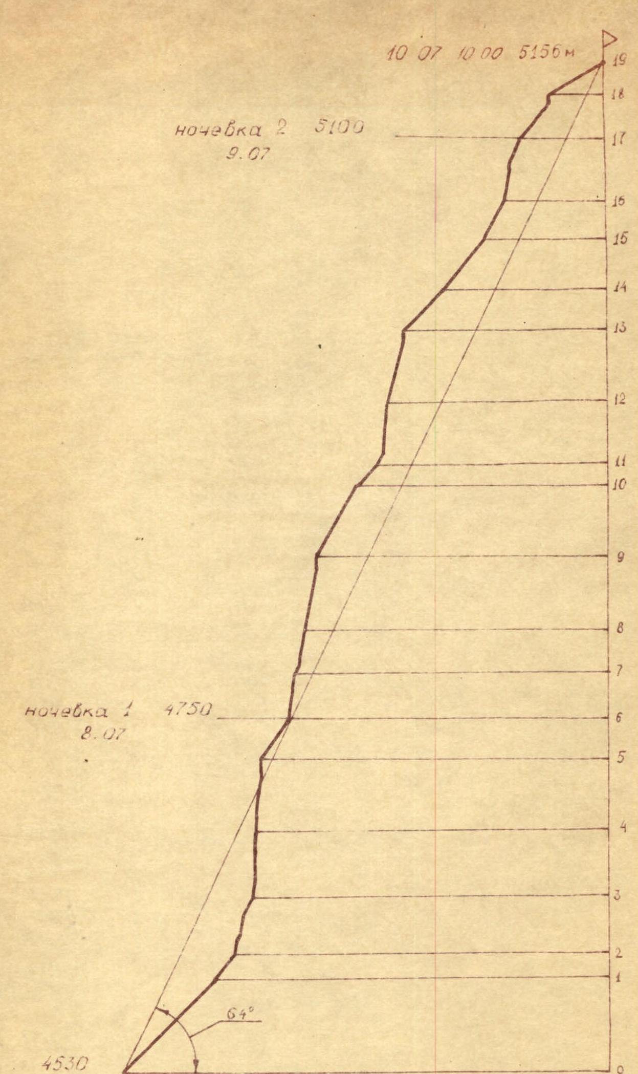
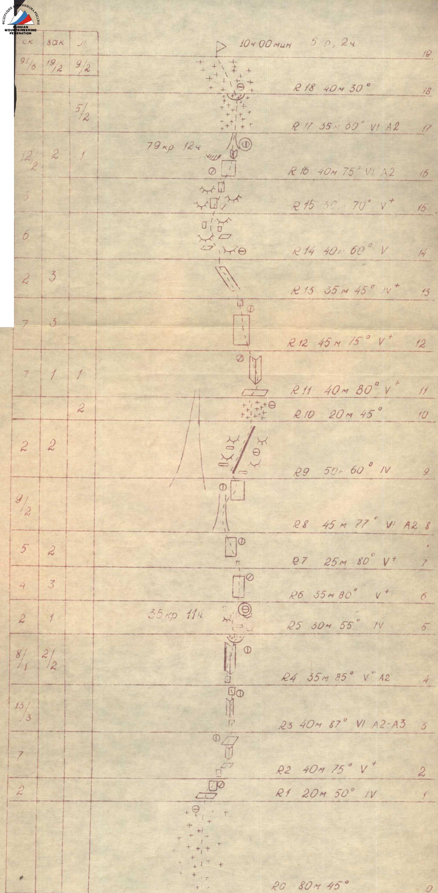
Description of the Route by Sections
From the bivouac across the glacier with a gradual increase in steepness and further:
R0–R1 Through snow and firn with a steepness of 45–50° to the base of a not clearly defined rock outcrop in the center of the East face. Movement hindered by fresh nighttime snow.
R1–R2 20 m of heavily destroyed, crumbly rocks. Rockfall hazard.
R2–R3 Wall 8 m, steepness 80°. Easily crumbling soft rocks. All holds are clogged with dirt and sand. Places for pitons are hard to find. Further along a 60° shelf 5 m to a steep (85°) internal corner (12 m) and along a 60° shelf to the right 15 m. Photo 5. Inconvenient belay spot. The leader, after organizing belay, provides top-rope belay for their partner and the first from the second team.
R3–R4 Up a steep 80° wall 10 m to the left, towards rocks eroded by water. Further up a 90° internal corner with very soft, brittle rocks 20 m. Very difficult climbing. Use of artificial technical aids (ITOs). The first passes the section without a backpack. Photo 6. 10 m wall with more solid rocks, steepness 85°. Driving pitons throughout the section is difficult due to soft rocks. Fixed ropes are organized on the section.
R4–R5 Wall 10 m, 85°. Movement from left to right from a sharp outer corner along its left wall into a deep, ice-covered 25-meter internal corner. Steepness of the section is 85–90°. Above the internal corner hangs a firn cornice! Between the firn and rocks, there is an exit to a simple, destroyed ridge. Ice pitons are used on the section. The organization of movement on the section is similar to section R2–R3.
R5–R6
 Route diagram in UIAA symbols.
30 m along the ridge to the bivouac site. The platform was built from ice and stones in 1.5 hours. The pronounced ridge character of the relief at the bivouac site ensured the necessary safety for the night. In parallel with building the platform, the IsaChenko—Nardov team processed sections R6–R7 and R7–R8.
Route diagram in UIAA symbols.
30 m along the ridge to the bivouac site. The platform was built from ice and stones in 1.5 hours. The pronounced ridge character of the relief at the bivouac site ensured the necessary safety for the night. In parallel with building the platform, the IsaChenko—Nardov team processed sections R6–R7 and R7–R8.
R6–R7; R7–R8 Wall 35 m. Movement up to the right along steep, solid limestone slabs to the base of a not clearly defined steep internal corner. Difficult climbing. Inconvenient but protected belay spot. 25 m up the wall of a wide internal corner to a niche to the right of a couloir with a waterfall. Rockfall hazard! Photo 7. The section is passed the next day via fixed ropes.
R8–R9 To the left of the couloir, up and to the right 40 m. Photo 8. In the upper part of the couloir, ITOs are used. Very difficult climbing. Poor belay spot. Photo 9. Tactics of movement similar to section R2–R3. Further, another 7 m of extreme climbing using ITOs and exit to a simple, destroyed ridge.
R9–R10; R10–R11 50 m along the ridge to a snow patch and 20 m along the snow patch (ice in the upper part) under a wall with a black streak. Teams move independently. Under the wall, there is a rockfall hazard!
R11–R12 Along the wall, traverse to the right 10 m across smooth, wet rocks and up 30 m along a not clearly defined internal corner filled with ice. Photo 10. Difficult climbing. Ice pitons were used during the passage. Teams moved independently, using left-behind pitons.
R12–R13 Wall 40 m, steepness 75°. Chocks go in well. Inconvenient belay spot. Teams move independently of each other. Further, a 5-meter overhanging wall before exiting onto an inclined shelf. Passage from right to left with a lift and hang on a loop.
R13–R14; R14–R15; R15–R16 Further to the left 35 m along a 50° shelf and 30 m across blackened "ram's foreheads". Very few places for driving pitons. Passed on friction. Steepness increases to 75°. Another 40 m across blackened "ram's foreheads". Difficult climbing on micro-holds and friction. Movement of teams with interaction.
R16–R17 Along a 20 m wall of solid limestone with good cracks for pitons — under an overhanging cornice. From under the cornice, traverse to the right under an overhanging internal corner. Up it 5 m of very difficult climbing. Further 15 m along a couloir filled with ice to a small snow ridge. The section is passed without a backpack, and then fixed ropes are organized. On the ridge, a small platform is carved out in the ice. Night's stay is sitting. Photo 11.
R17–R18 From the night's stay 30 m of 50° ice slope under a cornice. Photo 12. Passage of a 4-meter snow-ice cornice with the help of ITOs, using ice axes and ice screws without a backpack. Extremely difficult section. Photo 13.
Through 40 m of simple snow slope — the summit. Photo 14. Descent to the north from the summit along the ridge to the lowest point of the saddle with peak 4676 m and into the cirque under the East face.
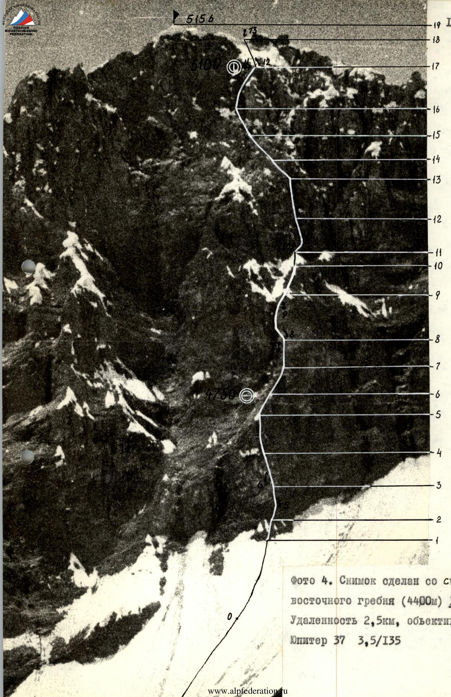
Photo 4. Taken from the slope of the East ridge (4400 m), August 3. Distance 2.5 km, lens Jupiter 37 3.5/135.